This is one of my favorite bits of writing from Geotripper. I didn't actually write it until 2016-17, but I actually sketched it out way back in 2009 while sitting in a Mexican Restaurant in Bakersfield on a 112 degree day. On that day we were in no hurry to leave, so I was reading about the presence of the Gardner Pinnacles, a seven acre island that is the oldest bit of exposed volcanic rock in the Hawaiian Island chain. As I worked my way through a delicious three-entrée plate of tacos and enchiladas, I was imagining how many species of animals and plants might have existed there, including many that would have disappeared along with most of the island itself. My musings ended up as several handwritten pages of text that would eventually become the first post of the series. I lost the pages somewhere within a few days, but I never forgot the desire to write a series of posts on this incredible place. An extended visit and field class in the summer of 2016 finally gave me the inspiration to get the whole project off the ground. Instead of describing the beaches and tourist hotels, I was seeking to understand the ancient Hawai'i, the one that existed before European contact, and the one that existed before Polynesian contact.
This has been a continuing series of my personal celebration of ten years of blogging. The compilation below appeared on May 5, 2017.
Since last summer I've been working on a blog series based on the geology, natural history, and anthropology of the Hawaiian Islands, loosely based on our field studies class last summer. There are a lot of stories told by these isolated islands in the middle of the Pacific Ocean. I finally reached the (possible) end of the series yesterday, and so today I'm putting together a compilation of the posts (click on the titles to get to each blog).
The Hawai'i That Was: A New Blog Series
This was the opening post that described what I hoped to do with the series. It included a picture of the Gardiner Pinnacles, the last bit of volcanic rock in the Hawaiian chain of islands. This bit of rock is the final remnant of an island that may have rivaled Kaua'i or Maui in size.
The Hawai'i That Was: To know what was we need to know Hawai'i today
I remember that the location and relative size of the islands meant little to me until I actually visited. In this post I laid out the geography of the main islands of the chain.
The Hawai'i That Was: Why Should We Care?
We are often far too ignorant of our dependence on the land and resources, and forget that they can be abused and wasted. All human societies alter the landscapes that they occupy to increase their chances for survival, and some are more successful than others. Hawai'i is a microcosm of the human experience on Earth.
The Hawai'i That Was: The Beginning of All Things, (Ba)salt of the Earth
Hawai'i begins and ends with basalt, the product of the partial melting in the mantle of the Earth. Basalt is the foundation on which the entire story of Hawai'i is written.
The Hawai'i That Was: The Abode of the Gods and Creation at Kilauea
Kilauea is the site of Hawaii's ongoing eruptive active, 33 years and counting. We saw some spectacular spattering when we visited at night. The video is in this post.
 |
| The lava lake in Kilauea Iki in 1959. We walked across it last summer |
The Hawai'i That Was: Walking a Lake of Fire in "the Little Source of Great Spewing"
In 1959, a huge eruption produced gigantic columns of spewing lava and filled a depression creating a lake of fire. It's still hot today nearly 60 years later. We walked across the abyss.
The Hawai'i That Was: Pu'u O'o, the Volcano We Couldn't See
The present day lava flows at Kilauea originate at a vent called Pu'u O'o a few miles east of the summit. We didn't get to see it on this trip, but I flew right over it in 2009. Here are the pictures!
The Hawai'i That Was: Living on Uncertain Ground - The First Human Wave Arrives
Hawai'i was one of the last uninhabited places on planet Earth. We get a first look at what life was like for the earliest colonizers, and begin to understand how they changed the islands.
The Hawai'i That Was: How Can the Biggest Mountain in the World Stay So Hidden?
It was a bit strange that we were on Mauna Loa, the world's biggest mountain, and barely ever saw it. The weather on the Big Island can be fickle! No worries though, I found a lot of images in the archives.
The Hawai'i That Was: Mauna O Wakea, the Opening to the Heavens, and the Realm of Ice
There is a second gigantic volcano on the Big Island that is taller than Mauna Loa, but of somewhat less bulk. Mauna Kea is considered the realm of the gods, and in a sense modern technology reflects this as some of the world's most powerful observatories on the summit search the Universe for understanding.
The Hawai'i That Was: A Tale of Two Kipukas, and Thoughts on the Rarest Plants in the World
Ever wondered about the world's rarest plant? How about one that existed as a single specimen? That died? Someone preserved just a few seeds, so it may come back (there are about 200 planted in the kipuka today). The role of kipukas in preserving the Hawai'i that was is described in this post.
The Hawai'i That Had Never Been: A Mountain That is Younger Than Me, Mauna Ulu
An exploration of a mountain that didn't exist when I was in grade school, along with another of Hawai'i's fascinating kipukas. Mauna Ulu is a fascinating place to explore.
The Hawai'i That Was: There was a Monster in the Water at Laupahoehoe
The tragedy of the 1946 tsunami at Laupahoehoe, and how it saved hundreds of thousands in the Pacific Ocean later on, but didn't in the Indian Ocean in 2004.
The Hawai'i That Was: Where are the Rivers? Waterfalls on the Big Island
Many parts of the Big Island have no rivers despite near constant rainfall. In other places, there are some really nice waterfalls! We explore some of them in this post.
The Hawai'i That Was: A Veritable Rainbow of Sand (and cute gratuitous sea turtles)
Did you know that there are beaches in Hawai'i that are made of gemstones? Or that beaches range in color from black to white with a whole rainbow in-between? Lets explore a few.
The Hawai'i That Was: Look at the Cute Squirrel! (NOT a squirrel)
You will no doubt see a squirrel-like creature on some the Hawaiian Islands. It's not, it's a mongoose, which is an important control on pests in other lands. In Hawai'i it IS the pest. It's had a devastating affect on the native birds of the islands.
The Hawai'i That Was: Exploring Pololu Valley on an Unstable "Dead" Volcano
The Big Island is not noted for having huge coastal cliffs, but there are some nice ones on the northeast coastline. The origin of the cliff is a notable story as well, that of a gigantic prehistoric landslide.
The Hawai'i That Was: What Happened to the Stones of Pololu? A Look at Pu'ukohala Heiau
This is the story of the Pu'ukohala Heiau, one of the most intriguing archaeological sites in the Hawaiian Islands. It was built by King Kamehameha I prior to his uniting of the islands under single rule. The stones they used to build it came from the other side of the island.
The Hawai'i That Was: Lapakahi, the Kind of Place Where the Rest of Them Lived
History seems to always be about the kings and presidents. We usually hear little about what life was like for the "commoners". Lapakahi is an archaeological site that protects a commoner's village on the northeast coast of the Big Island.
The Hawai'i That Was: Have We Got Some Real Estate for You! Exploring Kaloko-Honokohau National Historical Park
Hawai'i has a number of national parks, and one of them seems a strange choice, backed up against a Costo store near Kona. It's a barren lava flow, but treasures are hidden within its boundaries.
The Hawai'i That Was: Pu'uhonua o Honaunau, the Place of Sanctuary That Might Not Be So Safe (Geologically)
Can you ever feel safe? There are different kinds of 'safe' in Hawai'i. A few hundred years ago, small infractions could get you killed, but you could find safety and forgiveness if you could make it to a place like Pu'uhonua o Honaunau. Geologically though? Maybe not so much.
The Hawai'i That Was: Watching the Destruction of the Islands in Real Time
Flying from the Big Island to Kaua'i is like riding a time machine both backwards and forwards. We see the progression of the erosion and subsidence of the islands over the last 5 million years, but we are also seeing the future of the Big Island, five million years into the future.
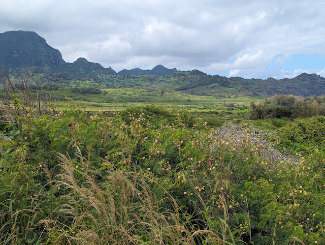
The Hawai'i That Was: We Arrive on Kaua'i and Find the Beauty of Age
The Big Island and Kaua'i are separated by only a few hundred miles, but they might as well be worlds apart. They are different from each other in many ways. We begin an exploration of the oldest of the main Hawaiian Islands.
The Hawai'i That Was: History and Beauty at Ke'e Beach and the Na Pali Coast.
On the north side of Hawai'i is a spectacular coast of some of the highest beach cliffs in the world, and the remains of a hula school that operated for perhaps 800 years. Not many universities in the world can make such a claim.
The Hawai'i That Was: An Idyllic Paradise on the North Shore of Kaua'i. Sort of.
Hanalei Bay is one of the most beautiful places on planet Earth. But even paradise can be a place of danger. Why are all the houses built on stilts?
The Hawai'i That Was: Hanalei, Where the Waterfalls Seem to Stream From the Clouds
The north side of Kaua'i captures the warm moist tropical trade winds, and collects prodigious amounts of rainfall. The mountains here are the wettest places on Earth, with one spot that gets nearly 500 inches of rain per year.
The Hawai'i That Was: Rising Out of Depression on Kaua'i, and Sleeping Giants
Have you ever wondered where that unique mountain in the opening of "Raiders of the Lost Ark" was located? Actually dozens of movies have been filmed on Kaua'i somewhere. We also climb the Sleeping Giant, a slumbering hero of the native Hawaiians.
The Hawai'i That Was: Into the Last Stand of Wilderness in Kaua'i, the Alaka'i Swamp
We take a hike into the last refuge of many of the native species of the Hawaiian Islands, a high-altitude "swamp" on the Alaka'i Plateau. It is an absolutely unique environment, unlike any on Earth.
The Hawai'i That Was: What the Worst Disaster You Can Think of? The Terror of Na Pali...
The cliffs of the Na Pali is one of the most incredible shorelines in the world, and are stunningly beautiful. On the other hand, they are evidence of one of the most violent of disasters, one that was so intense that it sent waves crashing against the other islands more than a thousand feet high.
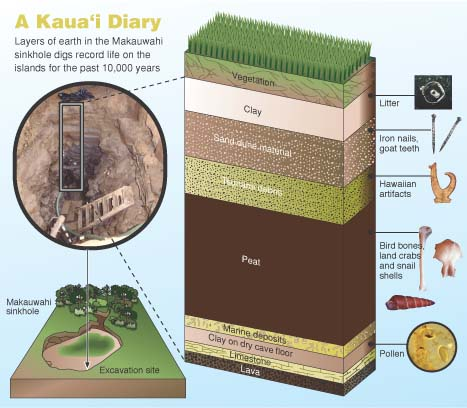
The Hawai'i That Was: The Lost Wetlands of the Mana Plain on Kaua'i
A portion of the west coast of Kaua'i exemplifies the conflict between the modern world and the natural environment that existed before. Volunteers are attempting to rebuild some of the wetlands that once existed on the Mana Plain.
The Hawai'i That Was: Waimea Canyon, the View You "Have" to Earn...
Our trip was near an end, and we took one last hike, one that end at the brink of a place so spectacular that it's been called the "Grand Canyon of the Pacific". We learned about the need to "earn" a view.
The Hawai'i That Was: The Final Refuge
For the our final blog in the series (for now at least), we have a look at Waimea Canyon, a deep gorge produced when half the island threatened to collapse and sink into the sea. We end with the realization that the natural environment that once existed in Hawai'i still survives in isolated corners here and there. These are the last refuge for many species, and many of us.