Showing posts with label Paleontology. Show all posts

Monday, August 5, 2024

Part 2: The Limestone Caves of Hawai'i - The Catastrophes at Makauwahi Cave


Makauwahi Cave and Sinkhole as it is today
I learned to my great surprise that Hawai'i has a few (very few, really) limestone caves. In part one I talked about the odd origin of Makauwahi Cave on the island of Kauai. In that post we learned that the limestone formed from limestone sand dunes that formed near Poipo Beach. The sand was lithified (glued together), and fresh water dissolved the limestone, forming the cavern, which has around 500 feet of passageways. At the end of the post I alluded to the fact that the cave was witness to three catastrophes that I'll look at today. On reflection, though, I think it's fair to say there were actually four catastrophes, one local, and the others island-wide.

Makauwahi Cave as it might have appeared 1000 B.C. Painting by Dr. Julian Hume
How did these catastrophes transpire? The rock formed around 400,000 years ago, and the passageways grew larger over time. By 7,000 years ago, wave action broke through and for perhaps a few centuries the cave was both a limestone cavern and a sea cave. Marine fossils formed a layer on the cave floor. But the waves may have contributed to the first catastrophe, because a short time later the roof of the cavern collapsed and formed a sinkhole. This is the bowl-shaped pit that is visible in the photo and painting above. The debris plugged the access to the sea, and the cavern and sinkhole filled with fresh water.

But is the collapse of a sinkhole a catastrophe? I guess it depends on your perspective. Some of the rarest of species on an island system with thousands of rare species would be those lifeforms adapted to living in total darkness. There are three blind species living in the darkness of Makauwahi Cave today, an amphipod, an isopod, and a blind spider (below) that feeds on the other two. These creatures have one of the most restricted environments possible on the islands, and the collapse severely restricted their living space. 

Blind cave wolf spider (descended from a surface-dwelling big-eyed spider, so it's sometimes called the no-eyed big-eyed Spider). Photo by Michelle Clark, USFWS.

The real "catastrophe" is what followed the formation of the pond in the bottom of the sinkhole. Animals found their way into the pit, but no way out. The pit became a death trap. Over the next few thousand years huge numbers of fossils, both animals and plants, accumulated in the sinkhole. The organic rich mud (peat) grew to be one of the thickest layers within the pit (see below). Excavations since the 1990s have revealed thousands of specimens that have revealed more about the pre-human environment on Kauai than any other site on the island.
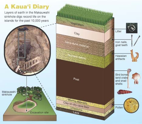
10,000 years of sediment, 33 feet thick, excavated at Makauwahi Cave Source: https://www.hawaii.edu/malamalama/2002/01/LostWorld.html
The primeval world of Kauai and the other Hawaiian Islands was unique. The islands are so isolated that no reptiles, amphibians, or mammals ever reached the islands (aside from seals and bats). The only vertebrate creatures that found their way to the islands were the birds. As a consequence, the environmental niches in the island ecosystem were filled by avian species, and over time they adapted and evolved to fully utilize the resources available to them. Species of hawk and owl filled the role of predator, especially of smaller birds. Ducks and geese grew to immense size and lost the ability to fly, given the lack of larger predators (see below). They took over the niche of plant-eaters and grazers. The honeycreepers were the most astounding example of evolutionary adaptation. From a single Asian finch-like ancestor, more than 50 distinct species evolved, filling the niches occupied elsewhere by parrots, hummingbirds, woodpeckers, and insectivores. Sadly, most of them are extinct and most of the survivors are critically endangered.

Every Hawaiian duck or goose here is now extinct, except for the Nene, on the right. The Nene almost went extinct in modern times. Source: http://www.cavereserve.org/resources/documents/slideshow.pdf
How unique is the Makauwahi fossil record? Of 107 bird species known to have been endemic to the Hawaiian Islands, nearly half (50 species) have been found in and near the sinkhole. Several species were found here and nowhere else on the islands. Some of the unique birds include a flightless goose, a turtle-jawed moa-nalo bird, a long-legged owl that probably fed on other birds, and a little duck with tiny eyes, a flat skull and tiny wings that probably fed on forest insects at night. Several of the birds like the hawk and Laysan duck no longer survive on Kauai, but are still found on other islands. 


Another catastrophe happened about 300-400 years ago. Excavators digging in the sinkhole found their way barred by a layer of boulders weighing as much as 200 pounds. These rocks were a mixture of basalt, lithified dune sands, and coral. The only process that could pile such debris in a sinkhole like this would be a huge tsunami. There must have been a village nearby because the deposit also contains some human artifacts like pieces of canoes, ropes, and ornamental objects. These rocks and other objects were carried over a ridge 27 feet above sea level, meaning the wave must have been much taller.

Humans in Hawai'i have always had to deal with the threat of tsunamis. The location of the islands near the center of the Pacific Ocean means that they can be hit by waves from all directions, generated by earthquakes in places as far-flung as Japan, Alaska, Washington, and Peru-Chile. Strangely, the largest tsunamis of all have been generated by the Hawaiian Islands themselves. Gigantic mega-slides from the flanks of the islands flowing onto the adjacent deep ocean floor have generated waves in excess of a thousand feet high! Thankfully, no such waves have occurred in historic time.
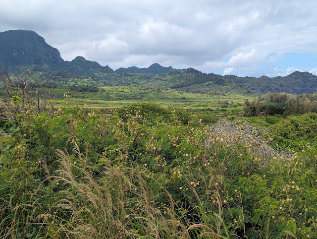

The biggest change at Makauwahi Cave was that the pond had been filled in and it was no longer a fossil trap. But the third and fourth catastrophes become visible in the sediment record of the cave: the arrival of human beings on the islands. 

The landscape surrounding the sinkhole (above) is far, far different than the one that existed prior to a thousand years ago when the first Polynesians reached Kauai, the third catastrophe. Hardly any native vegetation remains. Humans have been successful at geo-engineering their environments to provide the food and resources they need to survive and flourish. The colonizers brought taro plants, coconuts, kukui nuts, and gourds, as well as dogs, pigs, chickens, and whether on purpose or not, the Pacific rat. These invasive plants and animals overwhelmed the native flora and fauna, driving many species to extinction, or to much more limited ranges.

Source: http://www.cavereserve.org/resources/documents/slideshow.pdf

The effect on the birds was truly catastrophic. Evolving in isolation, they had no defense against the mammal invaders. The flightless birds quickly disappeared, and many other species suffered huge declines (above).

Still, from a human point of view, a certain equilibrium had been achieved, even if the native species went into a steep decline. Humans had been expanding across the Pacific islands for centuries, and knew what resources they would need to bring with them when they found new islands to colonize. They also had a social structure that was rather efficient and strict (however unjust to our present sensibilities) that allowed the native Hawaiians to thrive in their new environment, largely operating within the carrying capacity of the lands they were occupying.

The fourth catastrophe began unfolding in 1778 when Captain James Cook and his crew arrived. The full extent of this event is also revealed in the sediments of Makauwahi Cave, but we'll take that up in part 3.

The authoritative source of information on Makauwahi Cave is the book Back to the Future in the Caves of Kaua`i: A Scientist’s Adventures in the Dark; David A. Burney, Yale University Press, 2010.


Thursday, July 25, 2024

Visiting Hawai'i...for the Limestone Caverns? (Part one)

People visit Hawai'i for a great many reasons. There are the stereotypical reasons: beautiful beaches, surfing, palm trees, luaus and so on. There are other reasons: a wish to learn about the culture of the many people groups who call the island home, some of them for upwards of a thousand years. There are others who find fascination with volcanoes and lava flows. And the biology! The isolation of the islands has resulted in the evolution of hundreds, even thousands of species that exist nowhere else in the world.

I'm willing to bet that very few people come to the islands to tour the limestone caverns...

Limestone? Caverns? On the Hawaiian Islands?

Outcrop of limestone (!?) on the Mahaulepu Coast of Kauai.

There are actually a great many caves on the islands, but they are not the kind of caves that most people find familiar. They are called lava tubes, and they form when a lava river forms a ceiling of congealed basalt. When the lava flow ends, it drains out the tube leaving behind a long cylindrical cave. Hawaii has one of the longest such caves in the world, Kazimura, with a total length of 40 miles. The much shorter Nahuku Cave (formerly Thurston Cave) in Hawai'i Volcanoes National Park is well-known to park visitors.

Nahuku Lava Tube in Hawaii Volcanoes National Park

But limestone caverns are not a familiar sight on the islands. Before my last trip I didn't know that there were any such caves in Hawai'i. For one, a limestone cavern requires limestone and the islands are composed largely of volcanic basalt. There are coral reefs around the islands in many places and they are composed of calcium carbonate (calcite), the mineral that makes up limestone. But coral forms at sea level, and caverns form from the dissolving action of fresh water, usually above sea level. And the islands are sinking, not rising, so on the face of it there seems to be no opportunity for the development of large bodies of limestone, much less caverns in Hawaii. 

Photo courtesy of Allie Brown

And yet it happened here, on the island of Kauai (and also, upon researching the subject, in downtown Honolulu; check out Moiliili underground caverns if you dare). It was a unique situation, a cavern formed in a sand dune environment. The cavern has been known as Warrior's Cave, Grove Farm Cave, Limestone Quarry Cave and others, but some extensive research revealed the ancient name (from an 1885 student essay) to be Makauwahi, or "source of the smoke".

Sand dunes hardly seem like a place for cavern formation because most of the time sand is composed of quartz and other silicate minerals. Hawai'i's sands are not. They are composed sometimes of basalt fragments (the black sand beaches), but the white or yellow sandy beaches of the islands are mostly composed of bits and pieces of coral reefs, in other words, calcite, the ingredient making up limestone. On the south side of Kauai near the extensive resort complexes of Poipo Beach there are some extensive coral sand beaches. Over the millennia the constant trade winds have blown sand off the beach inland, forming sand dunes above the shoreline. This happened in stages starting about 435,000 years ago during an interglacial period when sea level was higher than today.

Cliff of eolian limestone showing the tilted layers of cross-bedded dune sands at Makauwahi.

When the dunes were stabilized by vegetation, thick layers of soil developed on the surface. Beneath the surface the sand was lithified (glued together) by dissolved calcite and silica derived from the overlying soil. Then the climate changed and dunes moved in again. Over time thick layers of solid limestone resulted from the petrified dunes.

Makauwahi Cave, courtesy of Tylor Ghaffari

The soil layers provide the last part of the process, carbonic acid. Mixed with groundwater, the acid ate away at the lower layers eventually producing the caverns themselves. Later on, dripping and flowing water produced a variety of cavern formations (speleothems) like stalactites, stalagmites, and flowstone. Makauwahi Cave has around 500 feet of passageways, accessed through a small passageway. And so we paid a visit during our field studies exploration of Kauai.

The thing is, if Makauwahi were simply a cave it would merit some attention, but that is not what makes it extraordinary. Makauwahi was the site of three catastrophes, one of which was local, and two others that were island-wide. And from these catastrophes, an amazing story unfolds about life on Kauai, past, present and future. That will be the subject of part two, coming soon (I hope)!

Thursday, January 31, 2019

Is it a Fossil Smuggling Conspiracy?? (Answer: No, it's something fun)


There's this suspicious storage container on our campus. It's been there for months, all through the construction of our much-anticipated Great Valley Outdoor Nature Lab. It's always closed and locked up and I've never seen what's inside. It's makes one wonder what could be stored there...
The other day though, workers were inside moving things around when I walked by. It was time to do some detective work, so I nonchalantly walked up and acted like a supervisor and looked inside. I was SHOCKED! There were fossils! Lots and lots of fossils! There was what seemed to be a Mosasaur, a T-rex skull, some ammonites, and many others. Had I stumbled upon some kind of fossil smuggling operation? Were we being used to hide ill-gotten paleontological discoveries?
Oh, for heaven's sake. It's not that at all. Can you see that pair of cement enclosures above? Those pits will eventually be mock paleontology dig sites where our children visitors can experience the thrill of discovery. The kids will be using shovels and brushes to uncover these treasures of the past while they learn of the natural history of the Great Valley here in California.
We've been waiting for thirty years for our Great Valley Museum to have an outdoor component that will bring alive the fascinating history of the natural ecosystems of our unique valley. Before it became the premier agricultural center for the continent, the Great Valley was an extensive prairie environment with Tule Elk, Wolves, Grizzly Bears and other interesting creatures. In the geologic past, the valley was an ocean environment that hosted sharks and swimming reptiles like Mosasaurs, Ichthyosaurs, and Plesiosaurs. The Outdoor Nature Lab will be a wonderful learning environment for our local children. There are just a few more weeks to go before it is "complete" (the newly planted trees and shrubs will take years to mature, of course).

Wednesday, February 21, 2018

Former Seas and Oceans: Searching for the Past in the Great Valley

The world changes. It changes minute by minute as events happen in human society, the disasters, the eruptions (such as Sinabung this last weekend), the wildfires, the earthquakes. Other changes are more incremental, such as the rise of mountain ranges and their removal by the relentless forces of erosion. Given enough time, huge changes take place, but no one in the midst of these processes would ever notice a difference over the course of their lives.

Teaching geology and the earth sciences is often a challenge, especially when we talk about the history of planet Earth. The rocks on the slopes before us may look barren and innocuous, but huge events reveal themselves when we start observing them carefully. As a professor at a community college, my students are usually neophytes in the geological sciences. They are seeing the earth from a new never-before considered viewpoint.

I was on the road this last holiday weekend, introducing my students to the geology of Death Valley National Park. Some are currently in geology classes, some already had taken my courses, and some were entirely new to the science. Death Valley is a long drive from our campus, so we left on Thursday night to cover the 200 miles of the flat Great Valley, and to get a head start towards the desert. We camped at Kern River County Park outside of the town of Bakersfield, and at the foot of the southern Sierra Nevada.

After a cold night, we awoke to a panorama of barren grass covered hills with no rocks in sight. A layer of soil covers them all, except where roadcuts expose a small part. We talked in camp before leaving about how geologists see landscapes. Where a politician might see only city and county boundaries, geologists see provinces, regions with a unique geological history that contrasts with the areas around them. The Great Valley of California, for instance, is a vast 400 mile long trough that has been collecting eroded sediments from the Sierra Nevada and Coast Ranges. It's been going on for at least 140 million years, and the sediments have accumulated to depths as great as 50,000 feet. More recently, perhaps during only the last one or two million years, the land was uplifted and gently tilted, causing the sediments to start eroding again.

We further talked about how geologists organize the rocks they see into formations, members, and groups. We recognize that in specific environments (ocean bottom, river floodplain, delta, sand dune) specific kinds of rocks will accumulate, and we can recognize by a change in the rock that the environment changed at some time in the past. In other words, as one looks at a cliff, different layers with different rocks and different colors show how the depositional environment changed, such as a river flood plain being inundated by rising sea level, or becoming drier and changing to a desert with dunes and the like. These unique layers are called formations. Formations are distinguished by being mappable and by having precise definable contacts with other layers above and below. Thinner distinctive layers within a formation may be defined as members, while several closely related formations (such as desert dry lake salt layers and desert sand dune deposits formed adjacent to each other at about the same time) may be classed as a group.

At our locality along the Kern River, a shallow seaway once existed. Maybe that's not such a stretch, since a rise of sea level of only 300 feet would inundate the area again. The presence of the sea is indicated by silt and sandstone layers, and the presence of numerous fossils. 15-16 million years ago, in the Miocene epoch, this was an ocean teeming with life. The shoreline must have been relatively close by because the fossil assemblage includes an occasional bone of a horse or camel, indicating a carcass that floated out to sea after a flooded river overtook the animal. The animals preserved as fossils are whales, dolphins, seals, walrus relatives, manatee relatives, and more than two dozen species of shark. Sharks have rarely-preserved cartilage skeletons, but their teeth are species distinctive. The size of the teeth range from barely visible to monstrous daggers almost a foot long (from the gigantic Great White relative Megalodon).
The rock layer is called the Round Mountain Silt, a formation within the Temblor Group. The incredible accumulation of fossils at the locality has been something of a mystery; suggestions include a volcanic ash disaster (no evidence of volcanism nearby, though), red tide poisoning (perhaps, but no clear evidence), or a feeding ground of large sharks (but large sharks were among the dead as well). A more recent suggestion is that the bones and teeth accumulated over a long period of time (perhaps 700,000 years) at the bottom of a sediment-starved basin (a deep trough a little farther offshore; such basins exist today in Southern California around the Channel Islands). Whatever the reason, the idea of finding fossils for the first time in their lives held great appeal for the students!

They shot off up the hill and although finds weren't abundant, almost everyone found a fragment of bone or a small tooth. The strange rectangular tooth in the picture above was that of a manta-type ray.

It's clear that some people spend a great deal of time digging and collecting at the site (the hillside has a prominent ledge where the digging takes place. Two years ago, one of the "serious" diggers was there, and showed us one of his really excellent finds, seen below.

The largest tooth ever found by any of my students was probably this one from 2011 (below). The variety in shape and size is apparent from the selection seen in the photo.

One warning about hunting for fossils in the region. The south end of the Great Valley is prime habitat for the fungal spores that cause Valley Fever. It's a nasty disease that is caused when the spores (which are in the dusty soils) get into your lungs and reproduce. If you ever give it a shot, take precautions...it's not a disease to be trifled with.

We got in the vans and started over the hill (Tehachapi Pass) on our way to the Mojave Desert, and then onwards to Death Valley, where our explorations would really begin.

Thursday, February 27, 2014

Out of the Valley of Death: Explorations in Red Rock Canyon

The next stop on our way to Death Valley National Park was one of the most ideal locations for learning the basics of stratigraphy to be found anywhere: Red Rock Canyon State Park in the El Paso Mountains along the Garlock Fault. The park protects exposures of the Miocene deposits of the Dove Springs formation (formerly the Ricardo formation), aged at about 8-12 million years. The formation of conglomerate, sandstone and claystone was laid down in alluvial fans, floodplains, and lakes in a semi-arid savanna environment. The region was home to a vast array of grazing mammals and predators, including extinct elephants, rhinos, three-toed horses, giraffe-like camels, saber-toothed cats, and bone-crushing dogs as well as smaller animals like ancestral skunks, martens, alligator lizards, rodents, and shrews. (follow the links to descriptions of each type of animal on the Los Angeles Natural History Museum website).
The park has stunning exposures of the sedimentary and volcanic rocks that illustrate many of the basic principles of stratigraphy (superposition, original horizontality, lateral continuity, and cross-cutting relationships). I worked with the students to observe and identify the rocks, and to work out a sequence of events that led to the formation of the exposures. And then I turned them loose to produce a rudimentary map of the geology of the area around the beautiful red cliffs.
It was February, and the sun was blazing! The temperature topped out at about 90 degrees. In a sense it was quite pleasant, especially compared to the frigid conditions back in the eastern United States, but it was also a reminder that we never had winter this year. There has been so little rain that there are parts of the Central Valley that have received less precipitation than Death Valley. It was a bit disturbing to realize how dry conditions are across the state.
Red Rock Canyon State Park has been the setting for numerous movies over the years, including old-time westerns, but my favorite movie scene was the opening sequence of Jurassic Park, where the protagonists were excavating velociraptors from Snakewater Creek or some such place in Montana. I sometimes find myself thinking "your cute little velociraptors wouldn't stand a chance against our bone-crushing dogs and sabertooth cats!".

Saturday, February 23, 2013

Hunting for Fossils in the Sierra Nevada...Wait a Minute, What Fossils are there in Granite?

Photo by Mrs. Geotripper
Last night I attended a great presentation on the dinosaurs and other (more interesting) Mesozoic reptiles found in California. It was given by Dick Hilton, a former prof at my school, who is currently teaching at Sierra College in Rocklin. I was invited to head up to the Sierra Nevada to look for fossils with Dick and fellow prof Noah Hughes, and I jumped at the chance.

But...fossils? In the Sierra Nevada? Isn't the Sierra Nevada composed of granitic rock? Granite and other plutonic rocks develop from cooling magma deep in the Earth's crust, an environment that is neither conducive to life, nor to the preservation of fossils. A quick look at a geologic map reveals that the Sierra is only about three-quarters exposed granitic rock. Most of the remainder is composed of metamorphic slate and metavolcanic greenstone, with a fair amount of serpentinite (California's state rock).
Metamorphic rock is the product of taking pre-existing rock and subjecting it to extreme heat and pressure. The resulting rocks, with names like slate, phyllite, schist, marble and quartzite, often bear little resemblance to their previous form, their protoliths. Any fossils that might have been part of the original rock are often destroyed in the process. There is a rich record of tectonic events leading to the formation of the Western Metamorphic Belt, a story too complex to even summarize in a short blog post. Long story short, fossils shouldn't be found in the Sierra Nevada. The rocks have been too distorted and altered. For the most part...

The Mariposa formation is a deposit that formed on the bottom of a deep sea off the coast of California in Jurassic time. The shoreline lay east of where it is today, and the Sierra Nevada was a different place: a series of active volcanoes led to a coastal forest. Dinosaurs, pterosaurs, and primitive mammals roamed the forests and floodplains. In the sea, large swimming reptiles including plesiosaurs and ichthyosaurs were to be found. The Mariposa is somewhat less altered than many other rocks of the metamorphic belt, and because of this, a few fossils have been found, fossils that enabled geologist to figure out the age of the rocks, an important step in unraveling the complex geologic history of the region.

The Mariposa formation is exposed along Highway 49, and we were searching for fossils in the vicinity of Don Pedro Reservoir. To my great delight, after a bit of sweating and slipping down wet grassy slopes we found some interesting specimens.
The most common fossils include the bivalve Buchia, an important diagnostic fossil indicating a Jurassic age for the unit.
I almost missed a small belemnite, which looks a bit like a fossilized cigar. The cylindrical fossil is the internal shell of a squid-like creature.
The prize find for me on this day was a small ammonite. Ammonites are relatives to the pearly nautilus which lives in today's seas. They can be thought of as an octopi with a shell. I have a spotty history with ammonites in the sense that for the last quarter century, I haven't been able to find any, and it hasn't been for lack of trying. I once stood in front of a productive outcrop with a noted paleontologist, and I watched him walk up and pull an ammonite out of the cliff face. I've been back to that spot many times over the last twenty years, and I have yet to find another. But today, I flipped a rock over, and there it was, a little tiny ammonite.
I didn't make that best find of the day, though. That honor belonged to Noah, my fellow prof at Modesto Junior College. The sample below shows a sprig of a species of redwood tree. This is an astounding find to me. Redwoods survive today in just three places in the world, on the northern California coast, in the Sierra Nevada, and in a small grove in China. But the trees once ranged across the northern hemisphere, and as Noah's find shows, they have been around for more than 160 million years. Think of it this way: dinosaurs once roamed through forests of redwood trees. And here in the rock was a distant ancestor to the Sequoia trees that grow just a few miles up the hill from our fossil site.
We were reminded of dinosaurs one more time today as we were driving home. We passed a large herd of modern dinosaurs who were displaying the kind of herd behavior that we think the large plant-eating dinosaurs displayed during the Mesozoic Era. Luckily they didn't attack!
Dick Hilton wrote the guide about the history of Mesozoic reptiles in the California region, and the book remains the best source of info about mosasaurs, ichthyosaurs, plesiosaurs, and the handful of dinosaur species found in the state. You can get the book at http://www.ucpress.edu/book.php?isbn=9780520233157 or any other online seller. I give it my highest recommendation!

Sunday, July 29, 2012

The Abandoned Lands...A Journey Through the Colorado Plateau: There is at least one forest in the Southwest that won't burn this year...

We continue our journey through the Abandoned Lands, the empty landscapes of the Colorado Plateau. We arrived at the national park the next morning and got a look at one of finest places to study Triassic history anywhere...the Chinle formation (or Group) is a complex sedimentary sequence that preserves a record of river floodplains and lakes that spread across Arizona, Utah, and several other states at the dawn of the age of the dinosaurs. Some of the earliest dinosaurs ever discovered have been found here.

But the neat thing about the Triassic is not the little dinosaurs. They had not really reached their dominance of the terrestrial ecosystem at this point in time. There were other creatures, some of them absolutely terrifying...like the phytosaurs.
Can you imagine wandering lost through a swamp and running into one of these? Phytosaurs resembled crocodiles, but were different in a number of ways. Some of them were also big...like 35 foot long in some instances.

There are lots of other creatures found in the sediments of the Chinle. The odd looking creature below is a Placerias hesternus, one of the therapsid reptiles, sometimes called the mammal-like reptiles. Huh? Since when is a reptile anything like a reptile? Well...when they have a more upright stance than reptiles, when they have differentiated teeth including fangs, and when they may even have been endothermic, i.e. warm-blooded. The therapsids were in fact the ancestors to the mammals, who appeared in latest Triassic time (they then presumably provided the dinosaurs with protein for the next 100 million years before an asteroid wiped out the reptilian overlords).

All told, the park is one of the richest Triassic fossil beds in world, with 200 kinds of plants, and dozens of therapsids, phytosaurs, amphibians, and early dinosaurs. But wait (as they say in late-night TV ads), there's more!
The floodplain and channel deposits make for some incredibly colorful badlands scenery. The bright colors result from the oxidation of metals in the clays, especially of iron. The clays are so easily eroded that soils don't develop easily, leaving behind a maze of gullies and channels.
There is a whole section of the park devoted to wilderness. No trails to speak of, but lots of interesting places to wander.
The park's riches extend to the human history as well. Abandoned lands? Yes. Few people live in the region today, but there is an 8,000 year history of human habitation. 600 archaeological sites are known within the park boundaries.
 There are some outstanding petroglyphs as well. Lots of them...
 Including this one. What do you see? Some think it is a dinosaur eating an unfortunate Puebloan, but others see a heron eating a frog. Of course, why would someone draw a bird eating a frog? Seems kind of ...ordinary to me.
Hmmm...I think I'm forgetting something. What is it? Oh yeah, I don't think I've mentioned what park we were exploring. It was actually originally established to protect some unique fossils: the petrified wood. I wonder how many parks have been missed because someone thought it was a sort of "one-note" place? Petrified Forest National Park? Why stop there? I see petrified wood in the curio shops all the time. Someone who thinks that is really missing out. The park is a fascinating place.

Most of the fossilized trees were carried from forests in surrounding highlands during floods. They were buried and the wood decayed away but was replaced by silica (quartz, in the form of agate and chalcedony). The wood is strikingly colorful; a lot of petrified wood from elsewhere occurs in pretty plain colors, but here there is a veritable rainbow in practically every sample. Entire trees, 100 feet long or more, are common in many parts of the park.

Petrified Forest is another place that suffered a lot of abuse before it became part of the national park system. Train passengers in the late 1800s stopped at the nearby station and walked off with tons of rock. A company once proposed to grind up the petrified wood to be used as an abrasive. Local citizens sought park protection as early as 1895, but it was 1906 before Teddy Roosevelt designated the site as a national monument. It became a national park in 1962.
Photo by Mrs. Geotripper
Theft is still a problem...apparently something like 12 tons of petrified wood get stolen every year. For what it is worth, stealing wood from the park carries a pretty serious curse. If you ask, the folks in the visitor center will show you the notebook filled with letters from people who had bad things happen to them while they possessed the stolen contraband. Legally collected wood can be purchased outside the park (they even give some away free; to get you inside the store, of course). If you are willing to do the legwork (mapwork?), you can find hundreds of square miles of Chinle formation on public lands (BLM) where non-commercial collecting is allowed.
In the meantime, if you are ever flying by on Interstate 40 and wonder if Petrified Forest is worth your time, well, I say yes, it is. And this is a forest that will never burn down, no matter how bad the droughts get...

Here is the explanation of my "abandonment" theme for this series: http://geotripper.blogspot.com/2012/06/abandoned-landsa-journey-through.html