Showing posts with label sand dunes. Show all posts

Saturday, November 28, 2015

The End of Fifty Miles of Sand: The Oregon Dunes

Or maybe, more properly, the beginning of fifty miles of sand. It's generally moving south from this point. The west coast of North America is mostly mountainous, with dramatic cliffs sloping almost directly into the sea. Where the east and south coasts of the United States might have strands of sand that run for hundreds of miles, sand is rare enough in the west to be a curiosity. If fifty miles of sand is found in one place, it is extraordinary. That's where I spent my Thanksgiving, next to Oregon Dunes National Recreation Area.
I've always made a point of resisting the orders of our superiors to go out and buy things the day after Thanksgiving, being a firm supporter of the the idea to "leave no child (or anyone else) inside" as a form of personal education. We went exploring the coastal area around Florence this weekend.
As I've noted in previous blogs, the so-called Coos Bay dune sheet extends for 56 miles (90 kms) from Coos Bay to Florence, and it is a strange and bizarre landscape that contains 85% of Oregon's active dunes. It's mostly protected as Oregon Dunes National Recreational Area. It isn't that there is simply a long expanse of sandy beach; the sand has been blowing and migrating inland, in some places nearly 3 miles, covering forests in some cases, and in other situations, stabilizing and becoming forest. This odd environment makes for unique ecosystem and geological landscape, mixing ocean, swamps, rivers, forests, and lakes.
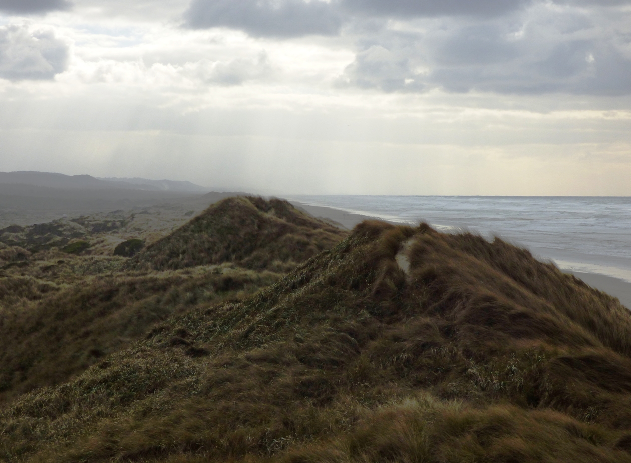
You can get a hint of the transition of dune to forest in the pictures here. I was quite literally standing above the very last dunes of the system, about eight miles north of Florence, where cliffs once again dominate the shoreline. The irregular hills are sand dunes that have been stabilized with European Beachgrass to augment the stabilization of migrating dunes. The native grasses have been pushed aside in many instances as the European non-native takes over. Because of the spread of grasses, 80 % of the dune sheet is covered by vegetation. In 1939 it was only 20% (US Forest Service data).
Only a few hundred yards inland, conifers have started to take root.  The rivers and streams that flow into the dune fields, along with a high groundwater table, have created a network of swamps, and more than two dozen ponds and lakes (before I began exploring this region I would have said that lakes form only from glaciers, sinkholes, landslides, or oxbows on floodplains; dune lakes were new to me). The complex provides a rich environment for wildlife.
The sand has several origins. The quartz rich sands have been eroded from distant sources in the Klamath Mountains and Idaho Batholith and carried to the shoreline environment by one of Oregon's many rivers. Other sand is locally derived, eroded directly from the sea cliffs, or carried onshore from offshore bars, sediment that may have originated during the ice ages when sea level was lower. Wave action produced the flat platforms on which the dunes accumulated.


It's a beautiful and dramatic landscape. If you ever get the chance...well, make the kind of choices that will get you chance to explore places like this!

Tuesday, August 4, 2015

Vagabonding on Dangerous Ground: Into the Land of Sand and Exploding Whales

The Cascadia Subduction Zone has raised mountains. The entire length of the convergent boundary, from California to British Columbia is marked by incredibly rugged cliffs and steep, forest-covered topography. There aren't a lot of sandy stretches of coast in southern Oregon, the kind that folks from Florida, south Texas, or the Atlantic seaboard would recognize. But in the central part of the state, there is one section of coast that is extraordinary.
The so-called Coos Bay dune sheet extends for 56 miles (90 kms) from Coos Bay to Florence, and it is a strange and bizarre landscape that contains 85% of Oregon's active dunes. It's mostly protected as Oregon Dunes National Recreational Area. It isn't that there is simply a long expanse of sandy beach; the sand has been blowing and migrating inland, in some places nearly 3 miles, covering forests in some cases, and in other situations, stabilizing and becoming forest. This odd environment makes for unique ecosystem and geological landscape, mixing ocean, swamps, rivers, forests, and lakes.

The sand has several origins. The quartz rich sands have been eroded from distant sources in the Klamath Mountains and Idaho Batholith and carried to the shoreline environment by one of Oregon's many rivers. Other sand is locally derived, eroded directly from the sea cliffs, or carried onshore from offshore bars, sediment that may have originated during the ice ages when sea level was lower. Wave action produced the flat platforms on which the dunes accumulated.

I've only just begun to explore this incredible landscape. I'm usually based out of Florence, so that's where these photos are coming from. Wave action is intense and unending. At times the waves are huge, and onshore winds can approach hurricane velocity. The first ridge of sand, the foredune, absorbs much of the impact of the wind and waves.


The dunes here have been altered extensively in the last century. Urbanization, where it's taken place has been secondary. The big changes resulted from the construction of jetties at the mouth of the Siuslaw and other rivers, which back up the sand along the coast as efficiently as a dam. The other has been the introduction of European beachgrass to augment the stabilization of migrating dunes. The native grasses have been pushed aside in many instances as the European non-native takes over. Because of the spread of grasses, 80 % of the dune sheet is covered by vegetation. In 1939 it was only 20% (US Forest Service data).

The rivers and streams that flow into the dune fields, along with a high groundwater table, have created a network of swamps, and more than two dozen ponds and lakes. Some of the larger lakes have been developed as recreational resorts.The complex provides a rich environment for wildlife, both local and migratory.

One very bizarre species in the area is the Darlingtonia californica, the carnivorous Pitcher Plant. I've written about the small park north of Florence previously. The plants can only grow in nitrogen poor environments like bogs or in serpentine soils. They get their nitrogen from the insects they consume.
One of the hazards of human colonization and development of the extensive dune field is the migration of the dunes over time, which could cover railroads and highways. That was one of the prime reason for efforts at dune stabilization in the early 1900s.

Another hazard, one not truly experienced in modern times, is the effect of large tsunamis in the event of a gigantic earthquake along the Cascadia Subduction Zone. Many of the lowland areas are expected to be inundated by tsunami surges that could reach depths of several tens of feet. Evacuation routes are prominently posted in developed areas.
There is one more hazard that Florence is rather famed for, although they probably wish it could be forgotten: exploding whales. If you haven't seen the video, you are in for a "treat". There is an extensive web presence if you want to learn more!

Thursday, March 19, 2015

The Incredible Dunes of Namibia: Geotripper becomes an Armchair Geologist for a day


Here at Geotripper I usually write about my travels, geological and otherwise. I feel inordinately lucky to have a job that allows me to travel a lot, introducing my students to the incredible world that lies beyond the borders of their town. But there are certainly a great many places I have never visited, and may never have the chance to.

I am also lucky to have a cadre of former students who also travel a lot, and some of them get to places I could not reach myself. For instance, one of my former students was on the logistical crew of an Everest expedition a year or two ago, and he brought back a few precious stones from high on the mountain. And then there are Noel and Art, a couple who are spending their time in Nepal and Africa. This week Art sent me a beautiful collection of photographs from their exploration of Namib-Naukluft National Park in Namibia. So today, I join you as an armchair geologist, enjoying the scenes of an incredible place in a far-flung location of our planet.
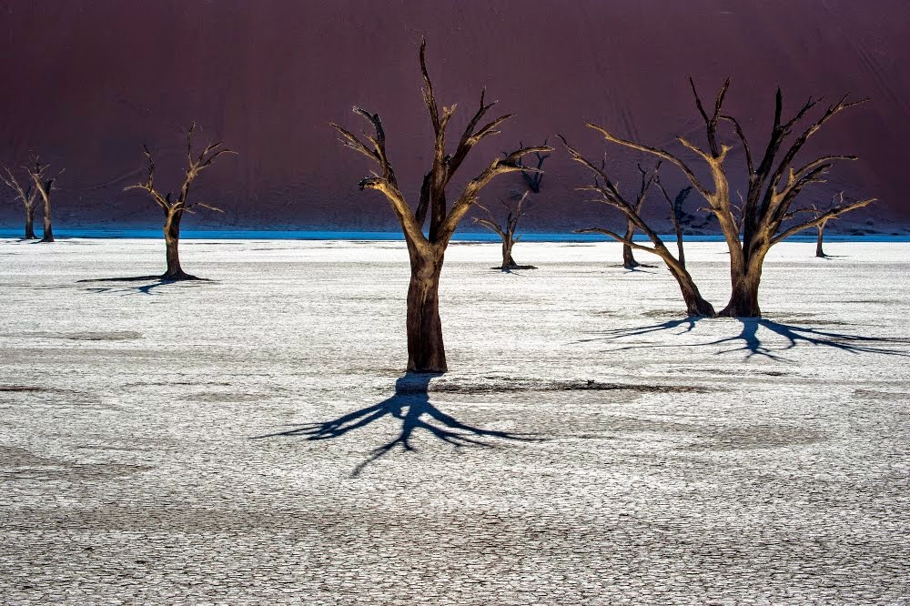
Deadvlei, a former oasis in Namib-Naukluft National Park. The dead trees are acacias.

Namib-Naukluft National Park encompasses just over 19,000 square miles, an area larger than Switzerland, or for you Californians, the area of about 18 Yosemite National Parks. It's the fourth largest national park in the world. It preserves the Naukluft Mountains and a vast region of sand dunes.
The main visitor destination in Namib-Naukluft National Park is Sossuslvei, a portion of the dune field that includes playas and an almost always dry river channel. In the Google Earth image above, on can see the light-colored playas (dry lakes), and the dry channel to the right. One of the world's tallest sand dune can be seen in the area. It's called (very imaginatively) Dune 7. It is 1,256 feet high (383 meters).
The second Google Earth provides a regional context (Sossusvlei is on the bottom of the image on the left side; it is the long narrow gray area). The north-south length of the map is around 150 miles. Namibia is on the west coast of South Africa, and it was part of South Africa until 1990, when the country became independent. The region has been a desert region for tens of million of years, which explains the wide distribution of the sand deposits. The sand is carried into the region along the coastline, and constant onshore winds blow the sand inland. The orange area on the left next to the coast is the vast north end of the dune field.

The Namibian desert is one of the driest in the world. It is dry because of a cold ocean current offshore that prevents the evaporation of water and causes the condensation of the atmospheric water offshore. Sometimes the fog will come onshore, providing a bit of moisture, but generally it is as dry as any place in the world except for some parts of the Atacama Desert in South America. Death Valley in California is practically humid in comparison.
The desert is described as one of the oldest in the world, dating back tens of millions of years. Contrast this with the Mojave Desert and Death Valley, which have existed as deserts for only 2-4 million years, with wet climates during the occasional ice ages.


The source of all the sand in the Namib is the coastline of the Atlantic Ocean. Rivers provide sand to  the coast and longshore currents and beach drift move the sand into the desert shoreline. The onshore breezes carry the sand inland.
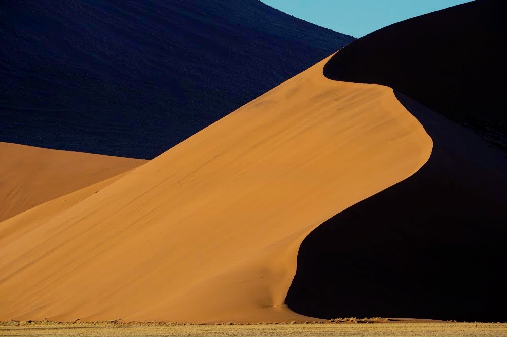
There are several kinds of dunes, based on the amount of available sand, and the variability of wind directions over the course of the year. Many of the dunes of the Namib desert are seif (or longitudinal) dunes, long parallel ridges of sand that extend for many tens of miles. When the dunes get backed up against a mountain range, they will have a much more irregular outline that sometimes resembles a starfish. They are called star dunes. Such dunes can accumulate vast amounts of sand and grow to great heights.


Deadvlei is one of the most popular photography spots in the park. The barren dead acacia trees were once watered by an ephemeral stream that changed course. Some of the dead trees may be hundreds of years old.

Dunes move when sand is carried from the base of the windward side and dropped down the lee slope, called the slipface. The dunes will migrate until they reach mountain ridges that interrupt the winds.

Many of the park visitors elect to do a flyover of the park. The vastness and loneliness of this landscape is overwhelming. I would not want to be lost here.

One section of the park contains exposures of a much older example of sand dunes. The billion year old rocks display the same kind of cross-bedding (diagonal layers representing the buried slip-face of dunes) that the modern day desert dunes possess. It's a marvelous example of uniformitarianism, the idea that processes that we can observe happening today also happened in the past (because the laws governing nature have not changed with time).
Many thanks to Art and Noel for sharing these wonderful photographs! Please regard them as copyrighted, however. I think they won't mind if the shots are used in school projects and the like, but if you want to use them in any formal publications, please notify me and I will forward their contact information.

Friday, July 12, 2013

Out in America's Never Never: Erg-onomics of a Desert Park

That's right, geologists can't help themselves. They like puns. This isn't a discussion of how to sit properly in a national park, or to hike without causing carpal tunnel syndrome in your toes. It's about sand, lots and lots of sand. Enough sand to cover as much as 625,000 square kilometers (about 240,000 square miles). My home state of California totals a little over 420,000 square kilometers, to give a bit of a comparison. Large "seas" of sand dunes are called ergs.

On our second day out in America's Never Never, we had reached Zion National Park in southern Utah. The park is justly famous for the sheer cliffs that tower over the valley floor, and for the beautiful scenery along the Virgin River. The scenery exists primarily because of one formation: the Jurassic aged Navajo Sandstone. The bold cliffs which sometimes have sheer drops of 2,000 feet (600 meters) are composed of cemented dune sands of an erg that once extended from southeastern California to Wyoming and Idaho. There are few if any places like it in the world today.
This vast amount of sand had to come from somewhere. Recent studies have demonstrated that it was probably eroded from the Appalachian Mountains and transported by rivers to the Midwest. The evidence is mineralogical, but it also makes sense because the eastern mountains were the only range in Jurassic time with enough elevation and extent to account for the approximately 60,000 to 140,000 cubic kilometers of sand (14,000-34,000 cubic miles). Some material may have come from the rising Sierra Nevada magmatic arc, but that range was small in comparison.
The Navajo Sandstone ranges in color from pure white to dark reddish-brown. Iron oxide minerals provide the color. Their presence may be related to petroleum that may have once existed in the unit (if it did, it would have been a resource to dwarf Saudi Arabia).

Zion National Park is just one of the spectacular exposures of the Navajo Sandstone to be found in the Colorado Plateau region (our stop in Valley of Fire also was in the same unit). It is in Zion that the greatest thickness of the unit is achieved, and the scenery is truly grand. A visit to the park should always include an exploration of the Narrows of the Virgin River, and if one is in good shape, a visit to Angels Landing or Observation Point is a great idea. If one is straining one's neck by looking up at the cliffs, a drive to Lava Point is in order. From the end of the gravel road, one can look down into the canyons from above.
Photo by Mrs. Geotripper
If you are having trouble imagining the sand dunes themselves, hop on over to nearby Coral Pink Sand Dunes State Park to the east of Zion National Park. We did, and had a great time looking at (and playing in) recycled Navajo Sandstone. The park has examples of several types of dunes, and has areas of active dune formation and migration as well as dunes that have been anchored by vegetation.
Photo by Mrs. Geotripper
Coral Pink Sand Dunes are far too limited in extent to be considered an erg (in the United States, only the Algodones Dunes of Southern California are considered to be of sufficient extent at 800 square kilometers). It is fascinating to think that the sand of which the dunes are composed once was carried in a Mississippian-sized river from a vast mountain range in the eastern United States, formed dunes in one of the largest sand seas ever to exist on the planet, was locked in solid rock for 200 million years, and only a few thousand years ago was released to bounce in the wind once again.
Photo by Mrs. Geotripper