Showing posts with label coastal dunes. Show all posts

Monday, June 10, 2019

Every Place Has a Story: Prichard, Oregon's Smallest State Park

I've been visiting Florence, Oregon for a number of years, and it is a beautiful place. The Siuslaw River reaches the sea near the town and at the northern edge of the Oregon Dunes National Recreation Area. Sea Lion Caves lie hidden in the coastal cliffs just north of town. But Florence holds one other distinction: it has Oregon's smallest state park. It's called Prichard State Wayside, and it totals an entire 0.5 acres. To be sure, Prichard is not the smallest park in Oregon. That distinction belongs to a city park in Portland called Mills End Park. It's located at in intersection in the city, and has a total area of 452 square inches.

A visit to Prichard State Park is not exactly a life-changing event. The half acre includes a grassy swale, a couple of trees, a small parking area, and no facilities at all. There's a single sign identifying the site. There's no interpretive signage, and little information on the internet about the history or genesis of the park. I'm guessing it was some land that was donated to the state, and the officials that be couldn't really decide what to do with it.

Looking at the park, I was reminded of something that I tell my students on the opening day of every class: geology is where you find it, and every place you find has a geological story. At first glance I was hard put to imagine an interesting geological story for this place. But a moment's reflection proved the opposite.

Let's take a look at the setting of the park. It is a grassy slope that is situated along the Siuslaw River, which from this angle looks like a huge body of water. But it isn't technically a river. It's a tidal estuary, and the wide body of water flows either downstream towards the sea or upstream in response to the daily tides. In a few hours the entire mudflat in these pictures will be covered with water. The area of tidal influence extends 26 miles inland, which is nearly 20% of the entire length of the river. Upstream of the tidal influence, the river is modest, with an average flow of about 2,000 cubic feet per second. That's less than a third of the more familiar Rogue River.


The story of any part of the Earth starts with the rocks that underlie the site. A quick look at the geological map of the park region shows that the "bedrock" is composed of "Qal", translated as 'Quaternary alluvium". Alluvium is our term for any of the loose sediment that covers the more solid rock underneath. "Quaternary" is the last little gasp of geologic time, encompassing the last 2 million years. The unit might include the mud of the estuary, river and or gravel, or dune sand. The Qal at Prichard is most likely slightly consolidated dune sands, which is a material that underlies most of the coastal areas in the vicinity of Florence. Sand carried along the coast by wave transport is blown inland by persistent onshore winds, forming the dunes for which Oregon Dunes National Recreation Area is justly famous.
The picture above shows the coastline just north of Florence. The region has undergone a significant change in the last hundred years or so. Migrating dunes can certainly be a problem in developed areas, so a European species of beach grass was introduced in the 1920s in an effort to stabilize the dunes. The grass worked too well, and sand has been trapped in the area adjacent to the shoreline, building into an ever higher ridge of grass-covered sand. The area inland has been starved of sand, so it has blown farther inland, leaving a low area called the deflation plain, a region now covered by small ponds and scrubby forests.

Sand is a famously unstable foundation for buildings (it's even in the Bible), but dunes that have been stable for centuries or millennia will sometimes be consolidated by calcium carbonate or other minerals in the groundwater. That is a much firmer surface to work with, and thus the development of the Florence area has been possible.

Going back in geological time often leads to strange changes in the appearance of the landscape. For instance, during the ice ages of the last 2 million years this little park would have looked far, far different than it does today. It's not because there was any ice; the glaciers that were present in Oregon were many miles away up in the Cascades. The big different was sea level. With so much ice locked up in the vast continental glaciers that covered almost all of Canada and northern Europe, sea level dropped to around 300-400 feet lower than today. Prichard State Park a few tens of thousands of years ago would have been perched on a terrace above a Siuslaw River ensconced in a deep river gorge hundreds of feet below. The outlet of the river would have been miles to the west of where it is today. 


One last aspect of the geology of any region is how it affects those who live there. Hazards present at Prichard would clearly include flooding and fires (especially in a time of global climate change). As noted earlier, the average flow of the Siuslaw River is about 2,000 cubic feet per second. The record flood on the river was around 45,000 cfs, and in that circumstance, the water would rise to inundate the little park.

The other very serious threat is that of tsunamis. These destructive surges of water could be developed by a massive earthquake on the Cascadia Subduction Zone that runs parallel to the coast. A quake has now been documented as having reached magnitude 9 in 1700. Such an earthquake is thirty times more powerful than the magnitude 8 quake that devastated San Francisco in 1906, and around a thousand times more powerful than the 1988 Loma Prieta earthquake (just short of magnitude 7). Tsunamis can also be generated thousands of miles away in places like Japan or Alaska. Whether local or distant, Prichard State Park would be a dangerous spot if a tsunami ever hit. There would be no "breaking wave" as is shown in many photoshopped images. The water instead arrives as a surge moving rapidly upstream at high speed. In moments, the park would be inundated to a depth of several tens of feet. The water would eventually recede, but then a second, third, and maybe fourth wave will follow.
Geology is everywhere, and everywhere has a geologic story, even Oregon's smallest state park. Check it out, if you can find it!

Sunday, July 29, 2018

The Carpeted Dunes of Oregon's Central Coast: The Principle of Unintended Consequences

So how about this plush carpeting on a sand dune? What? It doesn't look like a sand dune? Some people are such skeptics....let's find a trail...
There's the sand, with three or four feet of grassroots on either side.

We are at the north end of Oregon Dunes National Recreation Area near the estuary of the Siuslaw River in Florence. The grass growing on and covering these dunes is European Beachgrass (Ammophila arenaria), an invasive plant that was introduced in the 1920s. It was an excellent example of the principle of unintended consequences. The apparent solution of one problem resulted in a number of others.
There are some very specific problems associated with living along the Oregon coast between Florence and Coos Bay. The forty-mile stretch of sandy beaches and dunes ranges up to three miles inland and any roads or towns built there must contend with the instability of windblown sand and dune migration. The introduction of the European Beachgrass was seen as a way of stabilizing the dunes. In a sense, the grass did the job too well.
The grass has deep roots and spreads rapidly, overwhelming and replacing the native plant species. By anchoring the sand just above the shoreline, new sand blowing in from the beach is trapped in the grasses, causing the foredunes to grow higher and higher. Little of the new sand on the beach gets past the foredune system, and a form of stability is achieved.
Deflation basin in the south jetty area of the Siuslaw River

Without the infusion of new sand, the area inland of the foredune system becomes starved of sediment. The wind blows just as much and carries what sand there is farther inland, sometimes burying the forests growing there. What had been a dune complex with occasional islands of trees and vegetation becomes a deflation basin, a place where sand is removed to the local groundwater level. The wet ground and ponds found there become a stable surface where a thick forest can start growing. The dunes are stabilized to an extent, but much of the dune environment with all the native plants and animals is lost (see the comparison below).

Another problem with many invasive species is that they don't tend to stay where they are supposed to. The desired level of control was achieved in some places, but the grass continued to spread far beyond, invading areas like the Oregon Dunes where open dune environments were still desired. The beach grass is now found on coasts from Southern California to British Columbia. And it is extremely difficult to control or remove.

The grass can be pulled manually (by volunteers most of the time) but roots are always left deep in the sand and the grass soon sprouts again. The shoots have to be pulled seven or eight times before the grass is truly gone. It's hard work. Bulldozers and other mechanical means can be used, but the expenses are high. Some herbicides can be used as well, but the disruptions to the native species can be profound. All in all it is a sticky problem.
The coastal sand dune environment is a fascinating place to visit, and there are many recreational opportunities, but there are also opportunities to volunteer and help achieve a return to the natural conditions that existed before humans tried to mold the landscape to their liking. One place to start is the Oregon Dunes Restoration Collaborative which works to preserve and rehabilitate the dune system.

Saturday, November 28, 2015

The End of Fifty Miles of Sand: The Oregon Dunes

Or maybe, more properly, the beginning of fifty miles of sand. It's generally moving south from this point. The west coast of North America is mostly mountainous, with dramatic cliffs sloping almost directly into the sea. Where the east and south coasts of the United States might have strands of sand that run for hundreds of miles, sand is rare enough in the west to be a curiosity. If fifty miles of sand is found in one place, it is extraordinary. That's where I spent my Thanksgiving, next to Oregon Dunes National Recreation Area.
I've always made a point of resisting the orders of our superiors to go out and buy things the day after Thanksgiving, being a firm supporter of the the idea to "leave no child (or anyone else) inside" as a form of personal education. We went exploring the coastal area around Florence this weekend.
As I've noted in previous blogs, the so-called Coos Bay dune sheet extends for 56 miles (90 kms) from Coos Bay to Florence, and it is a strange and bizarre landscape that contains 85% of Oregon's active dunes. It's mostly protected as Oregon Dunes National Recreational Area. It isn't that there is simply a long expanse of sandy beach; the sand has been blowing and migrating inland, in some places nearly 3 miles, covering forests in some cases, and in other situations, stabilizing and becoming forest. This odd environment makes for unique ecosystem and geological landscape, mixing ocean, swamps, rivers, forests, and lakes.
You can get a hint of the transition of dune to forest in the pictures here. I was quite literally standing above the very last dunes of the system, about eight miles north of Florence, where cliffs once again dominate the shoreline. The irregular hills are sand dunes that have been stabilized with European Beachgrass to augment the stabilization of migrating dunes. The native grasses have been pushed aside in many instances as the European non-native takes over. Because of the spread of grasses, 80 % of the dune sheet is covered by vegetation. In 1939 it was only 20% (US Forest Service data).
Only a few hundred yards inland, conifers have started to take root.  The rivers and streams that flow into the dune fields, along with a high groundwater table, have created a network of swamps, and more than two dozen ponds and lakes (before I began exploring this region I would have said that lakes form only from glaciers, sinkholes, landslides, or oxbows on floodplains; dune lakes were new to me). The complex provides a rich environment for wildlife.
The sand has several origins. The quartz rich sands have been eroded from distant sources in the Klamath Mountains and Idaho Batholith and carried to the shoreline environment by one of Oregon's many rivers. Other sand is locally derived, eroded directly from the sea cliffs, or carried onshore from offshore bars, sediment that may have originated during the ice ages when sea level was lower. Wave action produced the flat platforms on which the dunes accumulated.


It's a beautiful and dramatic landscape. If you ever get the chance...well, make the kind of choices that will get you chance to explore places like this!

Tuesday, August 7, 2012

Sand...Lots of Sand

Wrapping up my mini-exploration of the coast of Oregon leads me to the plainest of all subjects: sand. Or maybe not the plainest. We use the grains of sand on the beaches of the world as some sort of analogy for infinity, suggesting that the diminutive grains are so common as to be hardly worth our notice. Sand is so uniform that it served as a time keeper (remember Dorothy and the witch in the castle...). Boring?
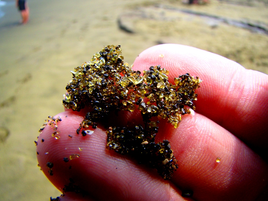
A sand composed entirely of the gemstone peridot; the green-sand beach in Hawaii
I was convinced otherwise a long time ago. What does it take? For one, a handlens or a microscope. Even the plainest looking sand can turn into a pirate's treasure when viewed up close. Garnet, peridot, and other gemstones can often be seen among the quartz grains, and a single grain can tell a complex story of erosion and deposition, of burial and lithification (turning to stone), and liberation once again by erosion. There is even an excellent geo-blog based on sand.

On the other, there is the big picture. Sand covers large parts of some deserts (although not as much as folks tend to think). And sand is a major component of our shoreline systems.

Traveling along the rocky shoreline of Oregon, I wasn't thinking much about sand, but that changed when I saw how much sand influenced the topography along the coast. It starts with the rivers: Oregon has a lot of rivers, in stark contrast to most of California, my home state. The rivers provide copious amounts of sediment to the coastal systems. In the first picture above, at Del Rey Beach, we were traveling across the vast beach formed by sediments from the Columbia River. Wide and flat. Featureless. But what happens when the wind picks up? And you can trust that the wind blows quite freely on the Pacific Northwest coast.

Some of the sand gets picked up and blown inland. That is when things start to get interesting...
At Pistol River Beach, we can see how the sand piles up in dunes and moves inland. The dunes start altering the arrangement of rivers, deltas and estuaries. And then life gets involved, as grasses and shrubs start stabilizing the dune surfaces.
When the grasses and other pioneer species build up the organic content of the sand, trees can get a roothold, and forests start to grow. At times the active sections of the dunes can shift and forests get buried. There are a lot of complex interactions going on in this environment.
I have often thought of lakes as being the result of either glaciers, landslides, or human dam-building (and the occasional volcanic crater filling). I hadn't given much thought to the possibility of lakes forming around dunes, primarily because I spend most of my time in deserts where there isn't enough water. But there are lots of lakes in the dune fields of Oregon, especially around Florence and the Oregon Dunes. Many of the lakes are fed by groundwater, while others are connected by rivers and streams.
I didn't take many shots of any of the big lakes on this trip, but you can see from these shots at Sutton Creek how dunes can conceivably form dams.
A fascinating region! I think I'll be back...