To a child who was raised along the beaches of Southern California, the Oregon coast comes as quite a shock. Beaches to me were places like Huntington or Balboa, where wall-to-wall people struggled to claim a few precious square feet where they could lay out a towel, and get sunburnt from head to toe (yes, the cultural habits of the sixties were terrifying; I'm lucky to not have skin cancer yet). Nature involved gulls trying to steal one's food, and getting stung by the occasional jellyfish.
My perceptions of ocean coasts were changed somewhat when I moved to Central California. The beaches we explore these days, Big Sur and the Marin Headlands, are more cliffs than sand. They are beautiful beyond measure, but they are not like Oregon. Few places are like Oregon.
My explorations of the Oregon Coast these days are centered around Florence at the north end of Oregon Dunes National Recreational Area. It is a truly alien place to a Californian! The strangest part is the sand wilderness. For a fifty-five mile stretch of coast, the shoreline is dominated by sand beaches. Constant onshore winds have blown vast amounts of sand inland, in places as much as three miles. In some localities the dunes buried mature forests. In others, forests have grown over the dunes. With the plentiful rainfall, the groundwater table is high, so many of the low places between dunes are occupied by lakes, ponds, and swamps. A fair number of them are large enough for boating and water sports. Others are more appropriate for hiking, wildlife observation, and contemplation. Our brief visit on Black Friday included a look at small Dune Lake adjacent to the national forest campground at Alder Dune (above).
Our other exploration was the short boardwalk at Holman Vista. The handicapped accessible trail provides access to Sutton Creek where it flows through a network of dunes and swamps, with a view of the distant mountain slopes as well. The dunes adjacent to the beach are anchored in place by European Beachgrass to augment
the stabilization of migrating dunes (the original plantings were in the early 1900s when people didn't worry too much about the possible adverse effects). The native grasses have been
pushed aside as the European non-native grass takes over.
Because of the spread of grasses, 80% of the dune sheet is covered by
vegetation. In 1939 it was only 20% (US Forest Service data).
The nature trail also offered what it termed "a view of the beach". That was true in the sense that an apartment might have a beach view if one leans out the window and cranes one's neck to see a bit of water in the distance between other buildings. In the picture above, note the beach view, a bit of white left of center. Look below for the zoomed view. We were in the midst of a series of powerful storms, so the surf was pounding the coast.
As I've pointed out in previous posts, the sand has several origins. The quartz rich sands were eroded
from distant sources in the Klamath Mountains and Idaho Batholith and
carried to the shoreline environment by one of Oregon's many rivers.
Other sand is locally derived, eroded directly from the sea cliffs, or
carried onshore from offshore bars. Some of the sediment that may have originated
during the ice ages when sea level was lower. Wave action produced the
flat platforms on which the dunes accumulated.
Although I call this a sand wilderness, it is not officially designated as one, but it is managed as a de facto wilderness. Vehicles are not allowed off the paved roads, so access is by trail only, or by beach walking. Access to parts of the beach is restricted during the spring because endangered Snowy Plovers nest in the area.
To this Californian, it is a true shock to look at an eight mile long stretch of beach and not see a single person. It was heavenly!
Showing posts with label Sutton Creek. Show all posts
Thursday, December 1, 2016
Tuesday, August 7, 2012
Sand...Lots of Sand
Wrapping up my mini-exploration of the coast of Oregon leads me to the plainest of all subjects: sand. Or maybe not the plainest. We use the grains of sand on the beaches of the world as some sort of analogy for infinity, suggesting that the diminutive grains are so common as to be hardly worth our notice. Sand is so uniform that it served as a time keeper (remember Dorothy and the witch in the castle...). Boring?
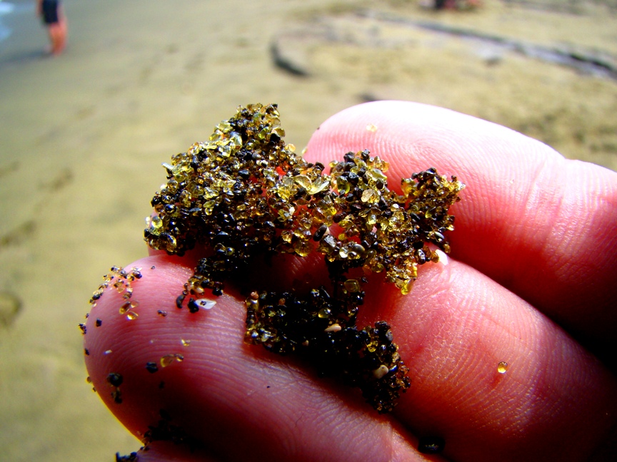
I was convinced otherwise a long time ago. What does it take? For one, a handlens or a microscope. Even the plainest looking sand can turn into a pirate's treasure when viewed up close. Garnet, peridot, and other gemstones can often be seen among the quartz grains, and a single grain can tell a complex story of erosion and deposition, of burial and lithification (turning to stone), and liberation once again by erosion. There is even an excellent geo-blog based on sand.
On the other, there is the big picture. Sand covers large parts of some deserts (although not as much as folks tend to think). And sand is a major component of our shoreline systems.
Traveling along the rocky shoreline of Oregon, I wasn't thinking much about sand, but that changed when I saw how much sand influenced the topography along the coast. It starts with the rivers: Oregon has a lot of rivers, in stark contrast to most of California, my home state. The rivers provide copious amounts of sediment to the coastal systems. In the first picture above, at Del Rey Beach, we were traveling across the vast beach formed by sediments from the Columbia River. Wide and flat. Featureless. But what happens when the wind picks up? And you can trust that the wind blows quite freely on the Pacific Northwest coast.
Some of the sand gets picked up and blown inland. That is when things start to get interesting...
At Pistol River Beach, we can see how the sand piles up in dunes and moves inland. The dunes start altering the arrangement of rivers, deltas and estuaries. And then life gets involved, as grasses and shrubs start stabilizing the dune surfaces.
When the grasses and other pioneer species build up the organic content of the sand, trees can get a roothold, and forests start to grow. At times the active sections of the dunes can shift and forests get buried. There are a lot of complex interactions going on in this environment.
I have often thought of lakes as being the result of either glaciers, landslides, or human dam-building (and the occasional volcanic crater filling). I hadn't given much thought to the possibility of lakes forming around dunes, primarily because I spend most of my time in deserts where there isn't enough water. But there are lots of lakes in the dune fields of Oregon, especially around Florence and the Oregon Dunes. Many of the lakes are fed by groundwater, while others are connected by rivers and streams.
I didn't take many shots of any of the big lakes on this trip, but you can see from these shots at Sutton Creek how dunes can conceivably form dams.
A fascinating region! I think I'll be back...
| A sand composed entirely of the gemstone peridot; the green-sand beach in Hawaii |
On the other, there is the big picture. Sand covers large parts of some deserts (although not as much as folks tend to think). And sand is a major component of our shoreline systems.
Traveling along the rocky shoreline of Oregon, I wasn't thinking much about sand, but that changed when I saw how much sand influenced the topography along the coast. It starts with the rivers: Oregon has a lot of rivers, in stark contrast to most of California, my home state. The rivers provide copious amounts of sediment to the coastal systems. In the first picture above, at Del Rey Beach, we were traveling across the vast beach formed by sediments from the Columbia River. Wide and flat. Featureless. But what happens when the wind picks up? And you can trust that the wind blows quite freely on the Pacific Northwest coast.
Some of the sand gets picked up and blown inland. That is when things start to get interesting...
At Pistol River Beach, we can see how the sand piles up in dunes and moves inland. The dunes start altering the arrangement of rivers, deltas and estuaries. And then life gets involved, as grasses and shrubs start stabilizing the dune surfaces.
When the grasses and other pioneer species build up the organic content of the sand, trees can get a roothold, and forests start to grow. At times the active sections of the dunes can shift and forests get buried. There are a lot of complex interactions going on in this environment.
I have often thought of lakes as being the result of either glaciers, landslides, or human dam-building (and the occasional volcanic crater filling). I hadn't given much thought to the possibility of lakes forming around dunes, primarily because I spend most of my time in deserts where there isn't enough water. But there are lots of lakes in the dune fields of Oregon, especially around Florence and the Oregon Dunes. Many of the lakes are fed by groundwater, while others are connected by rivers and streams.
I didn't take many shots of any of the big lakes on this trip, but you can see from these shots at Sutton Creek how dunes can conceivably form dams.
A fascinating region! I think I'll be back...
Subscribe to:
Posts (Atom)