Showing posts with label Great Valley Group. Show all posts

Tuesday, December 17, 2019

Damning Del Puerto Canyon, a Geological and Natural Treasure in our County

I awoke this morning mildly astonished to see my own words making up the headline of a Modesto Bee article about a proposed dam in Del Puerto Canyon, a deep gorge cutting into the heart of the Diablo Range in the western part of Stanislaus County. Del Puerto is one of the most unique landscapes of California's Coast Ranges, and as I noted, a geological and natural treasure. I was hugely dismayed to find that a proposal exists to build a large reservoir in the lower canyon, and my email to a colleague ended up being quoted in the Modesto Bee article linked above (hence my surprise at being quoted; I wasn't directly interviewed). The article accurately describes my concerns about the project. There are large landslides in the lower canyon that canyon that would almost surely be reactivated (or accelerated; they show evidence of recent motion) if the base is inundated by lake water. There are definite seismic concerns, as a probable active fault lies just east of the dam site. But my biggest concern is the effect the dam will have on the natural environment of the canyon.

The environmental impact report was published recently (read it here.). Comments on the Environmental Impact Report can be made at a public meeting from 4 p.m. to 6 p.m. Jan. 15 at the Hammon Senior Center, 1033 W. Las Palmas Ave., in Patterson. Written comments will be accepted until Jan. 27 at Del Puerto Water District, 17840 Ward Ave., Patterson 95363. If you appreciate the intrinsic value of our precious local canyon, I hope you will comment and make your voice heard.

I've written often about Del Puerto Canyon over the years (see many of the articles here), and to give you a feel for the unique nature of the canyon, I'm adapting an article from last May.
The strange and alien landscape in upper Del Puerto Canyon.
California has some really strange landscapes. A state that has beaches, mountains, volcanoes, forests, and deserts is going to offer many perspectives of the complex geological influences on the state. But for alien and otherworldly, few places in the state can compare to the journey you take when you follow Del Puerto Canyon from its mouth in the Great Valley to the headwaters in the Diablo Range. It's a journey into the middle of the world.
"Del Puerto" refers to "The Gate", the constriction of hard sandstone at the mouth of the canyon. This will be the site of the proposed dam. It will be more than 200 feet high.
I guess I should be a bit more specific. We journey to rocks that had once been part of the Earth's mantle, the 1,800 mile thick layer that lies just beneath the thin crust (3-50 miles thick). We can't reach the core of the planet, because no one can (despite sci-fi movies that say otherwise). Since mantle rock is very hot and is subject to convection, it is at least conceivable that the rocks we are exploring have once been close to the Earth's core.
This is an active landslide that will be partially inundated by the proposed reservoir. I am concerned about the effect of adding water to the slip plane. California's first discovery of dinosaur bones was at the top of this slope.
So how does one explore the Earth's mantle? Well, first one has to get through the crust, and the thinnest crust is that which makes up the ocean floors. It's nominally composed of basalt, but the details are more complex.

In Del Puerto Canyon, the ocean floor is covered by...a bit of sediment. About 25,000 feet of it! The sediments poured off the mountainous edge of the continent during the later part of the dinosaur era, the Cretaceous Period. There was a huge subduction zone that formed as oceanic crust plunged into the mantle beneath the edge of the North American continent. This so-called Cascadia Subduction Zone caused volcanoes to form where the Sierra Nevada is today, but the area offshore of the volcanic arc, the forearc basin, collected sediments. As the sediments accumulated, they pressed the crust downward and even more sediment piled on top. Eventually the layers reached a thickness of five miles.

The basin collected fossils as well. There were the usual shells of clams, snails and ammonites, a variety of shark teeth, and three groups of seagoing reptiles, the plesiosaurs (think Loch Ness), ichthyosaurs (think reptilian version of a dolphin), and 35-foot-long mosasaurs (think "swim for your life!"). Even dinosaur fossils have been found. The first dinosaur ever found in California, a Saurolophus, was discovered in the lower reaches of Del Puerto Canyon in 1935.

Eventually, one will reach the base of the oldest sediments, and encounter the ocean crust itself. Faulting obscures some of the relationships, and so in the picture below we see some of the oldest sediment on the right (somewhat brownish shale) and basaltic/andesitic volcanic rock on the left (greenish gray), separated by a fault. The volcanic rocks are harder, and the canyon takes on a more rugged aspect as we climb higher into the mountains.
The Coast Ranges of California are one of the youngest mountain systems in the world, having been uplifted mostly in the last 3 million years or so. The streams in this dry environment have not been able to downcut as fast as the mountains are rising, so they flow much of the way over bedrock. There are few floodplains in these mountains.
The water flows almost year-round and thus the canyon is a critical habitat for all kinds of wildlife. Dozens of mammals and reptile species are known, and nearly 200 bird species have been observed here.
Oceanic crust is basaltic in composition, but there are differences at depth. On the ocean floor, basalt flows form "pillows", globular masses of the volcanic rock. Beneath the pillow basalts, basaltic dikes fed the eruptions. Dikes occur when volcanic rock fills cracks and fissures in the surrounding rock. Since the surrounding rock is also dike material, the entire layer, a mile or two thick, is made of vertical sheet dikes. Feeding these dikes were magma chambers composed of...basalt! But some of the basalt was left at the base of the oceanic crust where it then cooled slowly to form a sparkling crystalline rock called gabbro. The entire suite of rocks is called an ophiolite sequence. The Coast Range Ophiolite sequence in Del Puerto Canyon is considered to be the second best exposed in the state, behind the Point Sal Ophiolite in southern California.

There is a spot in one of the most rugged parts of the canyon to investigate the gabbro where it was pierced by a vein of quartz (below). People have looked for gold here, but I doubt they found any.

Just a few more miles up the canyon we penetrate the uppermost part of the mantle. The rock originally consisted of ultramafic minerals like olivine and pyroxene, but here the rock has been metamorphosed into serpentine, California's state rock. The rock was sheared and faulted on its way to the surface, leaving shiny green and black polished surfaces (below).
And then we are there. In the uppermost part of the canyon, we reach the netherworld of mantle rock that was far less altered, so it retained some of its original appearance. In places we can see olivine and pyroxene crystals, as well as grains of chromite. These ultramafic rocks contain few nutrients needed by plant life, so only a few species can tolerate living on these slopes. Gray pines are among them, grasses generally are not. There are a number of wildflower species endemic to California that can be found here.
Looking at these shattered broken rocks from very deep in the Earth, one imagines hell freezing over. The forges of the demons and devils lie frozen in place, to be slowly removed by earthly weathering. They try to invade the surface realm, but they are defeated by the forces of the heavens, the water and ice falling from the sky.
It may have been a metaphorical battlefield, but in the end there is great beauty in the rarity of the flowers, plants and animals that thrive, or at least tolerate the conditions in the upper canyon.

Del Puerto Canyon is traversed (slowly) by Highway 130, originating in Patterson on the floor of the Great Valley. It can also be reached by way of Mines Road out of Livermore, a winding road out of the San Jose area over Mt. Hamilton and the Lick Observatory complex. It is not a fast way to go!


I know that there is a need for water in the Central Valley. But no matter how many dams get built, there will never be enough to meet the expressed needs and desire of agribusiness. But I feel that we need to keep some of the wild places, and Del Puerto is one of those especially unique places to learn about our planet. I hope you will make your voice heard about this project.

Sunday, May 26, 2019

What to do on a Saturday? Let's Go to the Middle of the Earth (via Del Puerto Canyon)!

The strange and alien landscape in upper Del Puerto Canyon.
California has some really strange landscapes. A state that has beaches, mountains, volcanoes, forests, and deserts is going to offer many perspectives of the complex geological influences on the state. But for alien and otherworldly, few places in the state can compare to the journey you take when you follow Del Puerto Canyon from its mouth in the Great Valley to the headwaters in the Diablo Range. It's a journey into the middle of the world. Our Geology Club made the trip a few weeks ago as an ending of the semester celebration. Odd way to celebrate? Did you simply party? We traveled half-way to the center of the planet!
"Del Puerto" refers to "The Gate", the constriction of hard sandstone at the mouth of the canyon.
I guess I should be a bit more specific. We journeyed to rocks that had once been part of the Earth's mantle, the 1,800 mile thick layer that lies just beneath the thin crust (3-50 miles thick). We couldn't reach the core of the planet, because no one can (despite sci-fi movies that say otherwise). Since mantle rock is very hot and is subject to convection, it is at least conceivable that the rocks we explored had once been close to the Earth's core.
So how does one explore the Earth's mantle? Well, first one has to get through the crust, and the thinnest crust is that which makes up the ocean floors. It's nominally composed of basalt, but the details are more complex.

In Del Puerto Canyon, the ocean floor is covered by...a bit of sediment. About 25,000 feet of it! The sediments poured off the mountainous edge of the continent during the later part of the dinosaur era, the Cretaceous Period. There was a huge subduction zone that formed as oceanic crust plunged into the mantle beneath the edge of the North American continent. This so-called Cascadia Subduction Zone caused volcanoes to form where the Sierra Nevada is today, but the area offshore of the volcanic arc, the forearc basin, collected sediments. As the sediments accumulated, they pressed the crust downward and even more sediment piled on top. Eventually the layers reached a thickness of five miles.

The basin collected fossils as well. There were the usual shells of clams, snails and ammonites, a variety of shark teeth, and three groups of seagoing reptiles, the plesiosaurs (think Loch Ness), ichthyosaurs (think reptilian version of a dolphin), and 35-foot-long mosasaurs (think "swim for your life!"). Even dinosaur fossils have been found. The first dinosaur ever found in California, a Saurolophus, was discovered in the lower reaches of Del Puerto Canyon in 1935.

Eventually, one will reach the base of the oldest sediments, and encounter the ocean crust itself. Faulting obscures some of the relationship, and so in the picture below we see some of the oldest sediment on the right (somewhat brownish shale) and basaltic/andesitic volcanic rock on the left (greenish gray), separated by a fault. The volcanic rocks are harder, and the canyon takes on a more rugged aspect as we climb higher into the mountains.
The Coast Ranges of California are one of the youngest mountain systems in the world, having been uplifted mostly in the last 3 million years or so. The streams in this dry environment have not been able to downcut as fast as the mountains are rising, so they flow much of the way over bedrock. There are few floodplains in these mountains.
The water flows almost year-round and thus the canyon is a critical habitat for all kinds of wildlife. Dozens of mammals and reptile species are known, and nearly 200 bird species have been observed here.
Oceanic crust is basaltic in composition, but there are differences at depth. On the ocean floor, basalt flows form "pillows", globular masses of the volcanic rock. Beneath the pillow basalts, basaltic dikes fed the eruptions. Dikes occur when volcanic rock fills cracks and fissures in the surrounding rock. Since the surrounding rock is also dike material, the entire layer, a mile or two thick, is made of vertical sheet dikes. Feeding these dikes were magma chambers composed of...basalt! But some of the basalt was left at the base of the oceanic crust where it then cooled slowly to form a sparkling crystalline rock called gabbro. The entire suite of rocks is called an ophiolite sequence. The Coast Range Ophiolite sequence in Del Puerto Canyon is considered to be the second best exposed in the state, behind the Point Sal Ophiolite in southern California.

We stopped in one of the most rugged parts of the canyon to investigate the gabbro where it was pierced by a vein of quartz (below). People have looked for gold here, but I doubt they found any.

Just a few more miles up the canyon and we penetrated the uppermost part of the mantle. The rock originally consisted of ultramafic minerals like olivine and pyroxene, but here the rock has been metamorphosed into serpentine, California's state rock. The rock was sheared and faulted on its way to the surface, leaving shiny green and black polished surfaces (below).
And then we were there. In the uppermost part of the canyon, we reached the netherworld of mantle rock that was far less altered, so that it retained some of its original appearance. In places we could see olivine and pyroxene crystals, as well as grains of chromite. These ultramafic rocks contain few nutrients needed by plant life, so only a few species can tolerate living on these slopes. Gray pines are among them, grasses generally are not. There are a number of wildflower species endemic to California that can be found here.
Looking at these shattered broken rocks from very deep in the Earth, one imagines hell freezing over. The forges of the demons and devils lie frozen in place, to be slowly removed by earthly weathering. They tried to invade the surface realm, but they were defeated by the forces of the heavens, the water and ice falling from the sky.
It may have been a metaphorical battlefield, but in the end there is great beauty in the rarity of the flowers, plants and animals that thrive, or at least tolerate the conditions in the upper canyon.

We turned around and headed back to more familiar habitats.

Del Puerto Canyon is traversed (slowly) by Highway 130, originating in Patterson on the floor of the
Great Valley. It can also be reached by way of Mines Road out of Livermore, or  a winding road out of the San Jose area over Mt. Hamilton and the Lick Observatory complex. It is not a fast way to go!

Monday, December 14, 2015

Driving to the Center of the Earth in Del Puerto Canyon...Sideways

Okay, not really to the center, but deeper than any drill or mine shaft ever went. Del Puerto Canyon in the California Coast Ranges provides a window into the Earth's mantle, while passing through more than ten miles of crustal material. Allow me to explain! We were there last weekend, a group of our students gathered together after finals to explore the canyon.

The Great Valley began as a forearc basin, a sequence of sedimentary layers lying on oceanic crust between a subducting trench and the edge of the North American continent. The sediments were derived from the erosion of the Ancestral Sierra Nevada, which at the time was a string of volcanoes not unlike the Andes or Cascades of today.
Source: https://commons.wikimedia.org/wiki/File:Franciscan_subduction_model.gif

What a fascinating time this was! Huge volcanoes were erupting every few decades, while large rivers were constantly eating away at the mountains. A diverse group of dinosaurs roamed the forests on the flanks of the volcanoes including hadrosaurs (duckbilled dinosaurs). Raptors and carnivores similar to T-rex and Deinonychus (the American version of the velociraptors) lurked in the trees and along the rivers. Various species of Pterosaurs flew overhead.
The first dinosaur found in California was discovered on this ridge above the landslide.
The very first dinosaur fossil ever discovered in California was found in this very canyon, by a teen named Al Bennison in 1936. The creature was a Saurolophus, a plant-eater that had been caught in a river flood. The carcass floated out to sea, and was eventually entombed in the sediments of the Great Valley forearc basin.
Fall colors in Del Puerto Canyon. Unlike the rest of the country, we believe in enjoying the fall until winter actually begins on the calendar.
Like the adjacent coastline, the sea teemed with life. There were creatures much like those of today, clams and snails (pelecypods and gastropods), fish, and sharks. And then there were the sea-going reptiles: the Plesiosaurs (the suspected "Loch Ness Monster" creature, unfortunately), the Ichthyosaurs (large dolphin-like reptiles), and Mosasaurs (35-foot-long swimming Komodo Dragon relatives). A new species of Mosasaur was discovered by Al Bennison just a few miles away from Del Puerto Canyon.


The sediments accumulated to an incredible thickness, more than 25,000 feet. The sediments were later twisted upwards to form the eastern flank of the Coast Ranges. The road in Del Puerto Canyon winds for more than 10 miles through the sandstone, siltstone, and shale that once formed the ocean floor. We were driving up canyon, but deeper down into the crust. We were looking for the Tesla-Ortigalita fault that marks the boundary between the so-called Great Valley Group, and the underlying Coast Range Ophiolite, a slice of oceanic crust.
We soon reached the rocks near the base of the Great Valley Group, and found the exposure of the fault zone (it cuts diagonally upwards to the left in the picture above). I visited this spot nearly twenty years ago with Al Bennison, who by then was long retired. He described the structural relationships to us, and pointed out that ammonite fossils (cephalopods related to the Pearly Nautilus and the Octopus) could sometimes be found in the shale on the right side of the fault. He walked over, glanced at the cliff for a moment and said "here's one", handing me the delicate fossil. I've been to that darned outcrop another twenty times or so over the years, and I've never found one for myself!
So of course, what happens when I take our Geology Club students to the outcrop last Saturday, students who have never seen this spot, some of whom haven't even learned about ammonites yet? Yes, they found one. Durn it all....
At this point we've driven 10 miles into the canyon, and passed through five miles of seafloor sediments. We've reached the top of the oceanic crust, known in this area as the Coast Range Ophiolite, one of the most complete such sequences in all of California. For the next part of the journey we sought to pierce the crust and travel into the Earth's mantle below. We continued up the canyon...

Tuesday, October 13, 2015

National Fossil Day is Tomorrow! Do You Know the Paleontological Heritage of Your Region?

A hadrosaur skull similar to Saurolophus, the first dinosaur ever found in California
Tomorrow is National Fossil Day, which if anything, is of far greater interest than a holiday concerning an Italian explorer discovering a Caribbean island a few hundred years ago. One of the really exciting changes in our region is that our fossil heritage is being celebrated, pretty much for the first time. We finally have a museum with the room to adequately showcase the incredible paleontological history of the Great Valley of California. If you've read my blog at all, you'll know it's the Great Valley Museum at Modesto Junior College.
Two fossils here, but one of them isn't quite dead yet. The other is a Mosasaur
The Great Valley of California has a rich history of fossil discovery. Sediments were accumulating here in Jurassic and Cretaceous time, so dinosaurs and other reptiles have been discovered here, although not in concentrations like those of the continental interior. The first dinosaur ever discovered in California was found in our county. It was a Saurolophus, a variety of duck-billed dinosaur (the hadrosaurs). It was found by a teenager exploring Del Puerto Canyon in the 1930s.
Even more interesting, especially in light of a certain dinosaur movie last summer, are the Mosasaurs, large marine reptiles that were the terrors of the Cretaceous seas. One of them, Plotosaurus bennisoni, was discovered by the same kid who found the Saurolophus. It may have been 35 feet or longer in length.
Some fossils are more mundane, but they're exciting because I found them. Those would include these Jurassic wood fragments from the Sierra Nevada foothills. They were carried into the ocean by turbidity currents in the vicinity of the subduction zone that was once active here.
The most diverse and plentiful fossils are those of the creatures that grazed and hunted up and down our valley in Pleistocene time. The Fossil Discovery Center in the Madera area a few miles south of us has the best collection on display of these animals. The animals include the sometimes terrifying Short-faced Bear, Saber-tooth Cat, American Lion, and Dire Wolf. The grazers included a number of species of horse, camel and antelope, as well as mammoths and giant ground sloths. Many other smaller animals have been found in the quarry at Madera (which doubles as the sanitary waste disposal pit).
Few people in our county and region have had a venue in which they could learn about this fascinating fossil history, which is why the newly opened Great Valley Museum is such a wonderful opportunity. We have a full-sized skeleton of a Saber-tooth Cat, and a life-sized Mosasaur skull.
The newest exhibit highlights the research being done in Miocene sediments of the Mehrten Formation near Turlock Lake by the faculty and students of California State University, Stanislaus. Former MJC student Jake Biewer designed the current exhibit. The students are investigating some of the fossil sites where six-foot long "saber-toothed" salmon remains were found, along with tortoises the size of those found on the Galapagos Islands. Other exhibits are currently in the planning stages.
It's hard to describe how exciting it is to finally have a place to tell the story of the fascinating animals that lived here before us. The response from the children of our valley has been infectious. They love finding out that their home was once the home of that terrifying creature from the dinosaur movie, but also that they themselves could be the one who makes the next great discovery.

Have a great fossil day tomorrow! Learn something new about the place that you live!

Tuesday, May 19, 2015

Driving Through the Most Dangerous Plate Boundary in the World: The Sea Floor that Became the Greatest Agricultural Region on Earth


Welcome to one of the strangest places on the planet! It's the size of West Virginia, but flatter than the Mississippi River Valley. It was once America's Serengeti, but 95% of the original landscape has been altered. It originated as the bottom of a sea, but now grows most of the nation's produce, and practically all of the nation's walnuts, almonds, and pistachios. It has been a major oil and natural gas producer. It is the Great Valley of California.
The Great Valley originated as a forearc basin, the seaway that is sometimes present between an oceanic trench/subduction zone and the margin of the continent. Tens of thousands of feet of sediment were deposited between the Jurassic Period and the mid-Cenozoic. As noted in the last post, the sediments have yielded up a fascinating collection of fossils over the years, including mosasaurs, plesiosaurs, ichthyosaurs, and even the fragmentary remains of a few dinosaurs. The valley was a seaway for the better part of 200 million years.

It is no longer a seaway. In the last few million years, California's tectonic framework underwent huge changes. The subduction zone was extinguished in the central and southern parts (subduction continues in the north state). A new plate boundary emerged: the San Andreas transform fault. Compressional forces along bends in the fault line raised the Coast Ranges, and the seaway of the Great Valley slowly gave way to river deltas, and then alluvial fans. In the last five million years, the Great Valley has been a terrestrial environment, with numerous river channels, gigantic lakes and vast grasslands. Large herds of grazing animals wandered the plains, pursued at times by terrifying predators (look for them in the next post of the series). Countless millions of birds made use of the wetlands during their long seasonal migrations.

The biggest and most far-ranging change in the Great Valley during the last five million years may have been that which took place only in the last 150: agricultural development. Millions of acres of grasslands, lakes and wetlands were drained and plowed. The rivers were dammed and diverted into artificial watercourses that took them hundreds of miles from their natural channels. Thousands of wells were drilled that brought prehistoric groundwater to the surface. Parts of the valley subsided thirty feet or more as the water was withdrawn. A mere 5% of the valley floor retains its natural character. Most of the animals are gone, shot to extinction (the California Grizzly Bear, for instance), or pushed to marginal environments in the Sierra Nevada or the Coast Ranges. The migratory birds are crowded into a few precious wildlife refuges up and down the valley.
I'm not really writing this to criticize the agricultural development of the valley. We have billions of people on the planet, and they insist on eating, so it would be foolish not to utilize some of the richest soils on the planet. I would even suggest to people who don't live in the valley that they might have a bit more respect for the people who work hard for low wages to plant and harvest the food that you eat. On the other hand, we do a lot of things wrong in our approach to agricultural development, and the waste of water is one of those things. The ongoing four-year drought has exacerbated the problem. There are problems with the overuse of pesticides and antibiotics, and with agricultural waste disposal. In many ways we are fouling (and paving over) our nest.

Still, living here does have some benefits. Given our journey through the most dangerous plate boundary on the planet, the Great Valley doesn't exactly look geologically menacing. It is relatively far away from the most active earthquake faults of the state, and is even farther away from the most dangerous of the state's volcanoes. We don't get hurricanes, violent thunderstorms or blizzards, and tornadoes are exceedingly rare. The idea of dangers from landslides is laughable (except that I know of at least one fatality in Modesto caused by a slide). But we do have two threats: droughts and flooding.We are in the midst of the worst drought in recorded history, but with the development of an El Nino weather pattern in the Pacific, we could have catastrophic floods in only a few months. We can never really predict what can happen. In 1861-62 the floods were widespread that the state capitol had to be removed to San Francisco for a few months. The valley was a gigantic lake twenty miles wide in places.
Flooding on the San Joaquin River in 2006.

The map below shows what could happen if we get a repeat of the 1861-62 floods, an event the meteorologists call an atmospheric river storm (ARKStorm). They also refer to this as the "other big one", because the potential for damage is greater than that of a major earthquake, at least in the Great Valley.
In the Great Valley, geology conspired to transform a sea floor into the richest agricultural region on the planet. For all the flat lands, it is an interesting place to study. In the next post we'll take a look at the strange things we've found just beneath the surface. In a garbage dump of all places.

Monday, May 18, 2015

Driving Through the Most Dangerous Plate Boundary in the World: Into the Realm of the Drowning Dinosaurs

The sediments of the Great Valley Group form the parallel ridges trending diagonally across the photograph.
California has a lot of potential for geological mayhem, with the San Andreas and many other faults, mountain-building, and volcanoes of many kinds. But it once was worse. During the Mesozoic era and the early part of the Cenozoic, the entire California coast was rimmed by a massive subduction zone. The huge earthquakes produced as the plate sank beneath the western edge of the continent would have produced horrific tsunamis. The sinking plate eventually produced bodies of molten rock that found their way to the surface, producing huge volcanoes, much like those found in the Andes Mountains today.

We've been making our way on a blog journey through this most dangerous plate boundary. The remains of the subduction zone have been lifted and exposed by erosion in the Coast Ranges. So far we have been observing the rocks of the accretionary wedge, the intensely deformed material that has been churned up within the trench of the subduction zone (see this post for an example). In our last post, we crossed through the oceanic crust of the Coast Range Ophiolite in Del Puerto Canyon in the Diablo Range. At the end of that post we crossed the Tesla-Ortigalita fault and entered into the exposures of the sediments of the Great Valley Group. We are now in the rain shadow of the Coast Ranges, and the slopes are barren of trees.
This large slump in the lower part of Del Puerto Canyon is the location of the discovery of the first dinosaur fossil ever found in California, in 1937.
The rocks of the Great Valley Group were deposited in a sea that lay between the trench and the western shoreline of the North American continent. The shallow ocean environment is called a forearc basin. The sediments consist of primarily of sandstone, siltstone, and shale that cascaded off the submerged edge of river deltas along the shoreline. The underwater landslides were called turbidity currents. The sediments pushed on the crust, and subsidence allowed vast thicknesses of sediment to accumulate. In the region around Del Puerto Canyon east of the Bay area, the layers total as much 25,000 feet. At the south end of the valley near Bakersfield, the rocks are around twice that.
All in all it doesn't sound like a good place to search for dinosaur fossils. The rocks are the right age, Cretaceous, but the dinosaurs were terrestrial creatures. They no doubt roamed the slopes of the the volcanoes and coastal plains of the continent, but few are known to have spent much time in the oceans. Finding a dinosaur fossil here seems about as likely as finding a cow or coyote skeleton at the bottom of the sea in the modern day. 
So, a hypothetical question: what if you did find a cow or a coyote skeleton on the sea floor? Could you explain it? It might take a moment, but one could imagine an intense flash flood along one of the rivers that flow off the Sierra Nevada and through the Great Valley, trapping and drowning a few cows or other creatures along the way. Their carcasses would have floated downstream, and eventually the bones could have sunk to the sea floor. I bring up this point because the sediments of the Great Valley Group have in fact yielded a few dinosaur fossils, and they probably did originate in a river flood.
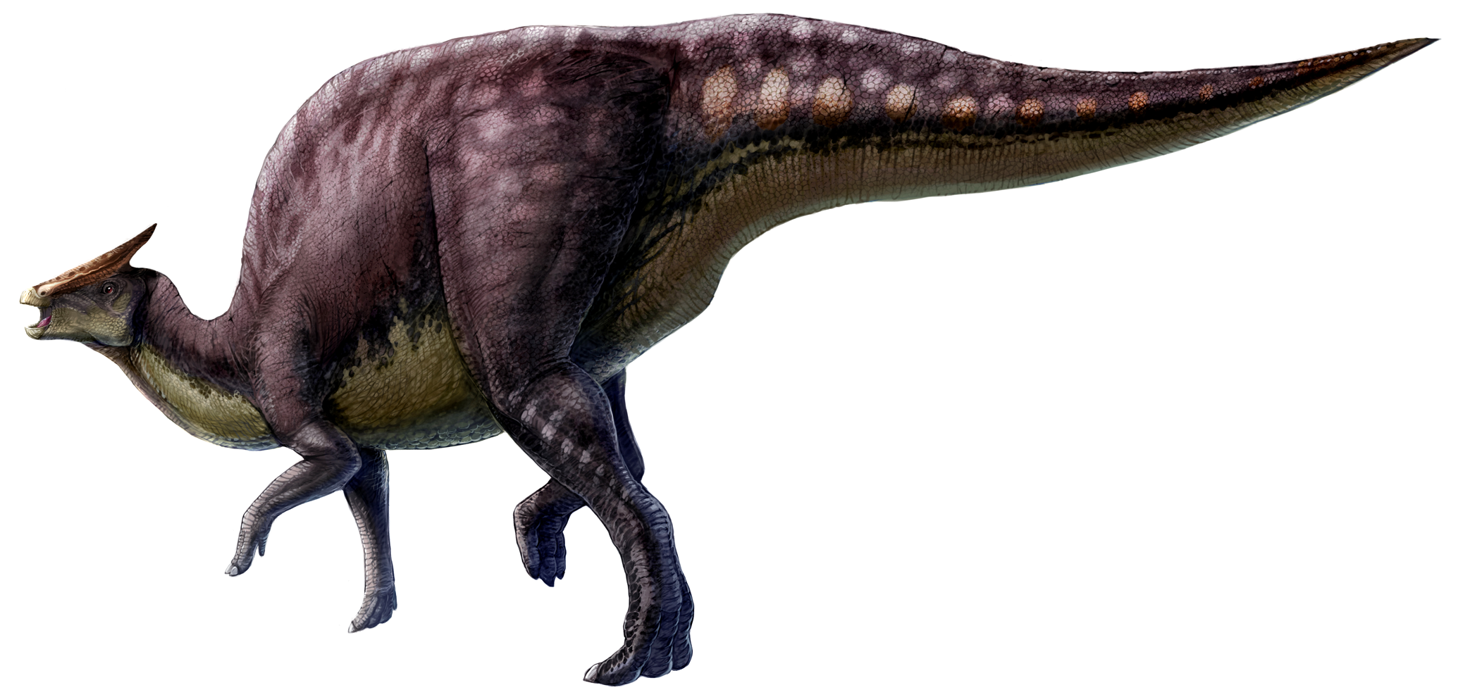
Source: http://upload.wikimedia.org/wikipedia/commons/4/4b/Saurolophus_scalation.png
The first dinosaur ever found in the state was found in 1936 in our own county, Stanislaus, by a 17 year old boy named Al Bennison. He was searching for shell fossils in Del Puerto Canyon near the landslide seen in the photo above when he found some bone fragments on the hillside. They proved to be the remains of a duck-billed dinosaur (or hadrosaur), possibly a creature called a Saurolophus.
These were big creatures, as much as 30 or 35 feet long. They were plant-eaters, and were among the last of the dinosaurs, along with Triceratops and the tyrannosaurs. Bennison's discovery made news at the time, but few people in our county are aware of the awesome paleontological heritage of our region today. I'm hoping that will be changing soon as we prepare a display for the new Great Valley Museum of Natural History at Modesto Junior College.
Source: http://en.wikipedia.org/wiki/Saurolophus
But Bennison wasn't done yet. A year later in another canyon nearby he found the remains of a fearsome marine reptile called a mosasaur. Mosasaurs were probably the top predators of the Late Cretaceous seas, possibly even consuming sharks (yeah, that's a mosasaur you are seeing in the Jurassic World movie trailers, acting like a Sea World Orca). They are descended from ancient terrestrial lizards similar to the Komodo Dragon.
Bennison's mosasaur was a new species and now bears his name: Plotosaurus bennisoni. Like the hadrosaur, few people are aware that they once lived in this region. We have a four-foot long skull of a mosasaur on display in the museum, and a more extensive display is in the planning stages.
Another species of mosasaur, Plotosaurus Tuckeri, was found a few years later a bit further to the south. As can be seen in the diagram below, these creatures approached the size of whales, and would be a terror if they lived in today's oceans.

There have been many other discoveries of Mesozoic dinosaurs and other reptiles like plesiosaurs and ichthyosaurs. The best resource for learning about these fascinating creatures is the book Dinosaurs and Other Mesozoic Reptiles of California by Richard Hilton of Sierra College. Check it out!
From Dinosaurs and other Mesozoic Reptiles of California, by Richard Hilton
I reached the mouth of Del Puerto Canyon and was met with a disturbing sight that was emblematic of the conflict between humans and the natural landscape that we inhabit. More on that in the next post.