Showing posts sorted by relevance for query The Sierra Beyond Yosemite. Sort by date Show all posts

Monday, January 26, 2015

The Sierra Beyond Yosemite: Where the Sierra Ends (maybe), and Gold


In some places it is pretty clear where the Sierra Nevada ends. For a hundred miles or more there is a solid rock wall that reaches a height of two miles in the Owens Valley. There is no mistaking that the mountains end at the cliffs above Lone Pine. Likewise, it's an unmistakeable demarcation between the flat Great Valley and the Sierra Nevada foothills. But in the central and northern Sierra Nevada, the division between "Sierra" and "not Sierra" is a line not so easily drawn.

From Mono Lake to the north, there are fault lines that mark the edge of the Sierra Nevada structural block, but they diverge from the watershed crest of the range, forming a series of north-trending ranges and valleys. These ranges, the Bodie Hills, the Sweetwater Mountains, the Pine Nut Mountains, and the Carson Range, are connected directly to the Sierra Nevada, are composed of rocks related to the Sierra Nevada, but are often considered "not" the Sierra Nevada. Geologically, the Sierra Nevada block is moving northwest from the adjacent Basin and Range province, making it a so-called "microplate", a much smaller version of the North American or Pacific tectonic plates. The mountains mentioned above are the jagged edge of the incipient plate boundary that has not yet completely separated from the rest of North America. If you are patient enough, buy up some desert scrublands  in the Great Basin of Nevada. In a few million years they may be oceanfront property!

Our journeys last fall through the "Sierra Beyond Yosemite" took us over Sonora Pass and into the lands east of the Sierra Nevada crest, a land that is both "Sierra" and "not Sierra". Our first destination was the ghost town of Bodie, between Mono Lake and Bridgeport Valley in the Bodie Hills.

"Hills" in this instance is a deceiving term. In any other setting, the Bodie Hills would be considered mountains, reaching elevations of more than 9,000 feet, and rising steeply above the Mono Basin. Still, the hills around the ghost town are more gently rolling, having not been glaciated, or deeply eroded by rivers. They lie in the rain shadow of the main Sierra crest, receiving only 12 inches of precipitation a year, making the region technically a desert (in climate terms, a dry-summer subarctic environment). Bodie competes with Barrow, Alaska as the place in America with the most freezing days per year: 308 of them on average. I just can't help thinking that this was a miserable place to live. Why would anyone...oh yeah, gold.

As I've described before, Bodie was a gold mining town. In the decades following the fabled Gold Rush, hungry miners started to explore the region east of the Mother Lode, and over the crest of the Sierra, and a lucky few found the elusive metal. W. S. Bodey was one of these; his exploration party found gold in 1859 in what later came to be known as the Bodie Hills (apparently the spelling was changed to help with the pronunciation). He may have found the gold, but he wasn't lucky. He froze to death the following year while making a supply run near Mono Lake.
The mines took some time to take off. The discovery of a rich lode in 1876 led to the development of the Standard Mine, and thousands of people came to the town of Bodie. The population peaked at 10,000 in 1880. The town developed a fearsome reputation for lawlessness, and one legend declared that a young girl, finding that Bodie would be her new home, said "Goodbye God, I'm going to Bodie". The town had its pride, too: an editor of the town newspaper insisted the punctuation was wrong; she had really said "Good, by God, I'm going to Bodie".

The mines were active for years, producing $34 million in gold (at a mixture of prices, $20/ounce in the 1800's and early 1900's, and $36/ounce in the 1930's). The gold is worth a great deal more at today's prices, perhaps $1 or 2 billion. As time went on, gold production waned, and the town began to die away. The Standard Mine shut down in 1913, although sporadic efforts at mining continued through 1942. A disastrous fire in 1932 destroyed most of the buildings in the town (only 110 of the original 2,000 buildings remain).


The gold at Bodie resulted from hydrothermal activity in the heart of a volcanic center that was active between about 14.7 and 8.0 million years ago. The field included at least 20 vents, including four trachyandesite stratovolcanoes. The town lies along the boundary between the deeply eroded Silver Hill and the Potato Peak cones, while the access road to Highway 395 meanders between the Willow Spring and Mt. Biedeman complexes. The sage covered hills reveal little of the volcanic violence that formed this landscape, but they do provide an analog for the appearance of the pre-glacial Sierra Nevada crest. The alpine topography of the present-day Sierra Nevada crest is a very recent geologic event. Without the glaciers, the Sierra Nevada would have been a different place entirely.

Today the town is a popular state park, and it has been declared California's official Gold Rush Ghost Town (as opposed to California's official Silver Rush Ghost Town in Southern California). I have a hard time envisioning a life here. I imagine that it was a relief on the coldest winter days to get out of the house or tent and get underground in the mines where it was warmer. Today, during a visit in the warm summer months, it is a photographer's playground, and an interesting place to learn about ancient Sierra Nevada geography.

Wednesday, January 28, 2015

The Sierra Beyond Yosemite: A Stunning Impenetrable Wall of Solid Rock

Mount Whitney from the Alabama Hills in the Owens Valley
Impenetrable. The imaginary mountain barrier surrounding Mordor in the Lord of the Rings has nothing on this real-life wall of solid granite. For more than one hundred miles, from Mono Lake south to Owens Lake and beyond, there is a 10,000+ foot high crest that divides California from the rest of the country, which stops almost all precipitation from Pacific storms, and which denied immigrants an easy path to the gold-fields of the Mother Lode.
The Wheeler Crest from Bishop in the Owens Valley
The Sierra Nevada is a barrier to travel of all kinds: paths, wagon trails, roads, and railways cross the mountains in only a few places, and those few places present serious engineering challenges. No paved roads cross the mountains for well over 150 miles between Tioga Pass in Yosemite National Park, and Walker Pass south of Sequoia National Park (The only minor exceptions: Sherman Pass, a paved former logging road is inappropriate for heavy traffic, and a dead-end road that travels to Devils Postpile). The only freeways exist at Donner Summit and Tehachapi Pass.
The Sierra beyond Yosemite provides some of the most stunning scenery on the planet. On the previous day of our fall trip we had crossed the Sierra Nevada at Sonora Pass, and explored the ghost town of Bodie, but the sun was disappearing in the west by the time we arrived at our campsite in the little town of Bishop in the Owens Valley. For those on our trip who were seeing these lands for the first time, it was a revelation to wake up to the high remote ridges of granite and metamorphic rock that towered over the flat valley floor.
Mt. Humphreys (13,996 feet) above Bishop, California in the Owens Valley
Many would say that Death Valley is the ultimate expression of basin and range style geography, and in many ways it is extraordinary, but few valleys in the world can match Owens for pure grandeur. One one flank, the Sierra Nevada rise to elevations exceeding 14,000 feet. On the other, the White Mountains average 11,000 feet, culminating in White Mountain Peak at 14,252 feet. Given the roughly 4,000 foot elevation of the floor of Owens Valley, the declivity is twice as deep as the Grand Canyon. Comparisons are unfair, of course, since the Grand Canyon is water-carved, and the Owens is of fault origin, but the scale of the landscape is grand in any case.

The origin of the wonderful scenery is a two-edged sword, of course. The faults that formed the Owens Valley are still very active. In 1872, the Owens Valley fault was responsible for one of the biggest earthquakes in the state's recorded history. The magnitude 7.8 event killed 27 people (out of a total population of around 300), and shifted the ground dozens of feet along a scarp more than eighty miles long.
The Palisades Group of peaks on the Sierra Crest from Sierra View in the White Mountains

One of the most spectacular ways to see the mountain wall is to climb into the White Mountains and see most of the Sierra escarpment from one view point. It's called (by incredible coincidence) Sierra View, which is a pullout on the equally spectacular road to the Ancient Bristlecone Pine Forest. From the one view, one can see the Sierra Crest from the Tioga Pass area to south of Mt. Whitney, a distance of over 100 miles. We were blessed with a clear morning despite the fires raging throughout the region.


Later in the day we drove south to Lone Pine, which lies on the floor of the Owens Valley beneath Mt. Whitney, which at 14,505 feet is the highest point in the lower 48 states. After a number of stops, we ended up at an old mine, the Reward, and watched the sun sink over the high ridges.
Sunsets for the people of the Owens Valley are different. There is no horizon over which the sun emerges or sets. There are only high ridges. When the conditions are right, the light show is wonderful.


Saturday, January 24, 2015

The Sierra Beyond Yosemite: Donnell Vista and Sonora Pass

It's gloomy and foggy, and I haven't seen the sun for days. It's a few more weeks before field season (Death Valley!), but I can't help exploring the sunnier places from warmer times. I'm looking back at the pics from our fall semester where we explored a lot of places in the Sierra Nevada that aren't Yosemite.

That's the thing. Say "Sierra Nevada", and a lot of people will immediately think of the beautiful valley of the Ah-wah-nee, John Muir's favorite place on the planet, and in many ways mine as well. But the floor of Yosemite Valley is about 7 square miles. The national park covers 1,190 square miles (3,081 square kilometers). But the Sierra Nevada? It covers 39,612 sq miles (102,594 km²).  You could hide more than 30 Yosemite parks in the rest of the range. It is in fact the largest single range in the lower 48 states (large mountain systems like the Rockies and Appalachians are made up of numerous smaller sub-ranges).
So we are off onto a short exploration of some of the wonderful corners of the Sierra Nevada that aren't Yosemite Valley. We are following a week's worth of our trips last fall that took us over the range at Sonora Pass and down the east side of the range as far as Lone Pine and Mt. Whitney. We'll also explore the other national parks of the range, Sequoia and Kings Canyon, which we visited on a second trip.
We began our journey in some serious smoke from a series of fires burning through the western slopes of the Sierra Nevada. The drought and the fires have been catastrophic. We made a stop at the Twain Harte Lake exfoliation site. I wrote about it back then, and it was picked up on Reddit and IFLS, links that led to the post being the most read ever on Geotripper (12,400 hits and counting). We emerged from the smoke and climbed the upper reaches of the Stanislaus River, approaching Sonora Pass, which after Tioga is the highest paved highway over the Sierra Nevada at 9,624 feet (2,933 meters). Tioga Pass in Yosemite is 9,943 ft. (3,031 m.).

In a series of ice ages, glaciers covered about 30% of the range, reaching as low as 3,000 feet or so in some of the deeper canyons. Yosemite is simply the most famous of the glacially carved gorges, and many others are of incredible and spectacular beauty. This was not always fully appreciated, and some of these wonderful wild canyons were dammed for irrigation storage and domestic use. Hetch Hetchy is the most familiar, but the canyon below Donnell Vista on Highway 108 has also been inundated. Still, the glacial heritage of Middle Fork of the Stanislaus is evident from the viewpoint. The steep canyon walls of granitic rock and the overall U-shape of the valleys are the result first of ancient river erosion and then modification by thick rivers of ice.

If you look at the second picture above, you can see some unusual looking mountain peaks. Their blocky flat aspect indicates they are composed of something different than the "expected" granitic rock. They are the remains of lava flows, ash flows and volcanic cones that once covered this part of the Sierra Nevada. Indeed, until 9 or 10 million years ago, the Sierra looked far more like today's Cascades Range than the lofty glacial peaks we see today. There were a number of snow-covered stratovolcanoes, but much of the remainder of the range was composed of lower hills. The upper reaches of Highway 108 where it crosses Sonora Pass cut through some of the volcanic rocks.
We stopped a mile or two short of the pass to get a detailed look at the granitic rocks. Depending on the relative proportions of plagioclase and orthoclase feldspar and quartz, rocks may be identified as granite, granodiorite, tonalite, diorite, or monzonite. The rock exposed just below the pass is called the granodiorite of Topaz Lake, dated about 89 to 83 million years ago, during the Cretaceous era. It was intruded in the deep crust about 4 or 5 miles down where it cooled slowly, forming visible crystals of feldspar, quartz and dark minerals like biotite mica and hornblende.

Glaciers scoured the surface of the granodiorite, polishing it and providing a nice view of the structure of the rocks. Some of the orthoclase (potassium feldspar) has formed huge blocky crystals easily visible in the shot below. Even better, during the intrusion process, blocks of the surrounding rock broke off and sank into the magma. Composed of minerals that had higher melting points, it didn't melt, but instead persisted as an alien mass in the granitic rock. Such inclusions are called xenoliths. They provide a peek at what existed here before the intrusion of the magmas.

We drove over Sonora Pass and headed into the barren lands beyond. Our destination was the site of a gold rush, but not the one that Californians are familiar with.

Thursday, January 29, 2015

The Sierra Beyond Yosemite: Wait! Is that...a Glacier?

People who visit Yosemite Valley often think about glaciers. Even those with no geologic background quickly become aware of the role of glaciers in forming the valley, but the thoughts are often of the past. It's been 11,000 or 12,000 years since any glaciers have been in the bottom of the valley, and it's been around 800,000 years since glaciers filled Yosemite Valley. The glaciers seem a part of the distant past.
When we reached the crest of the White Mountains on our fall field trip, we could see across the Owens Valley to the highest ridges of the Sierra Nevada. It was late September in one of the driest years ever recorded in California. And yet...there was still ice in the high country. How could any snow still be left after one of the hottest summers on record?

A closer look through the zoom lens told the story. The isolated patches weren't snow at all, they were ice, and the cracks and fractures tell us that the ice has been moving. In other words, these are glaciers!

Glaciers would not seem to be a California phenomenon. Too much sunshine, too many droughts, it just doesn't seem to be the kind of place where snow could accumulate and compress year after year, decade after decade, until the frozen mass starts to slip under the weight of 100-200 feet of ice. Indeed, the permanent snowline would be in excess of 15,000 feet or more, and no peaks in California are that high. But given certain areas with cold "microclimates", glaciers have persisted in the ranges, in the shaded hollows of the highest mountains where the sun almost never shines.

According to the U.S. Geological Survey, there are nearly 500 glaciers in the Sierra Nevada, but none of them is very large, the biggest being only a mile (1.6 km) wide and half a mile (0.8 km) long. The total area covered by glacial ice in the Sierra is only about 19 square miles (50 square km). We were looking at some of the largest remaining glaciers, those that persist beneath the peaks of the Palisades Crest, a group of 14,000 foot mountains on the east boundary of Kings Canyon National Park.

It is known that there was a much warmer period several thousand years ago following the last major ice age, so these are not remnants of those Tioga stage glaciers. Small glaciers like these would have melted completely away. There was a general worldwide cooling event in the 1700s, the so-called Little Ice Age, and it was in those decades that these glaciers accumulated.

If you want to see the remaining glaciers of the Sierra Nevada, make your plans now. Since the early 1900s, the glaciers have been shrinking, and they have already lost 50-80% of the volume that existed at the time of their discovery. Glaciers are one of the most sensitive indicators of global temperature, and most of them are shrinking worldwide (a precious few are expanding, but because of increased precipitation in some areas; their climate is still warming). Many or most of the Sierra glaciers will be gone in a matter of decades. That will lead to some serious changes to the alpine climates of the Sierra, especially as they will no longer be there to provide streamflow during the driest times of the year.

It's been a long time since I was able to visit a glacier in the Sierra (it was back in 1982. It was the biggest of the Palisades glaciers, the one in the picture above, and as I stood at the base of the ice, I was able to see the Sierra's youngest natural lake, a tarn produced as the glacier receded. The lake didn't exist in 1950. It's sad that these small reminders of the awesome power of ice will soon be gone. I hope I have at least one more chance to see them up close.

Tuesday, December 31, 2019

A Resolution Recommendation: See the World. See as Much of the World as You Can

Grapevine Mountains in Death Valley National Park
When I first began to think about what I wanted to do with my life sometime in my teens, I knew I wanted a job that would take me outdoors for much of the time. When I was in high school, "earth science" or "geology" didn't exist as a course choice. So far as I knew, the "outdoor" major was to be a wildlife biologist, and I started heading that way. But in my first semester at community college, all the classes were full, so I took some course called "earth materials". The next semester I took "earth history", and a field course to the Grand Canyon. And by then I was hooked. I wanted to teach geology (many thanks to my first teachers, Marlin Dickey and Rod Parcel).
Death Valley National Park
My journey to a degree in geology was not an easy one. I did okay in my community college courses, achieving a pretty good GPA, enough to get me into a quality program at Pomona College, where I found the limitations of lazy study skills. I spent three years getting my act together, and another two working for the department before I started the graduate program at the University of Nevada, Reno. Once again I was challenged to the limits of my abilities, especially with a young family to support. But I made it through, holding a crying baby at two in the morning while typing my thesis on a Commodore 64 computer with a daisy wheel printer.
The Trona Pinnacles in the California Desert at Searles Lake
Somehow, I made the cut for a position as a laboratory teaching assistant, and later adjunct faculty at Santa Barbara City College. I worked there for four wonderful years before I was fortunate enough to be chosen as an instructor of geology at Modesto Junior College, where I've been teaching for 31 years and counting.
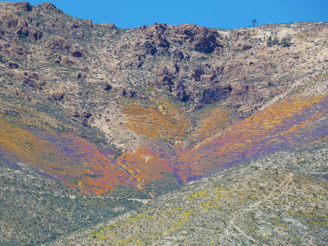
The 2019 "Super-bloom" in the Mojave Desert of California
Geology provided my one of the greatest gifts of my life. A doctor explores the human body. A computer programmer explores the circuitry of processors. A chemical engineer explores atoms and compounds. But a geologist explores the earth. And I can't imagine a greater privilege. The greater privilege though has been that I have spent a third of a century introducing students to a world outside the confines of their home cities. There is nothing quite like seeing the response of a student seeing the Grand Canyon or Yosemite Valley for the first time in their life.
Mesquite Dunes in Death Valley National Park
Our world, despite our horrible abuses, is a wonderous place, still full of beauty and adventures. Seeing it is a marvelous journey, but having some understanding of how it came to be gives the adventure deeper meaning. Even the plainest of landscapes, say the Central Valley (to us the Great Valley) has a fascinating story, one filled with oceans full of mosasaurs and plesiosaurs, gigantic sharks, and savannas full of mammoths, giant sloths and sabertooth cats.
A Five-spot in Death Valley National Park
Not everyone can travel and explore the planet, for lots and lots of reasons. When digital cameras became widespread, and this thing called the blogosphere appeared some time back in the cyber-early Pleistocene, I finally realized I had another tool with which to share the world. In 2008 I started this blog, with the idea of posting lots of pictures of the beautiful places of the planet. It became a way of introducing the wonders of the planet with people far beyond the confines of my college. I never dreamed I would still be doing it twelve years (and more than 2,100 posts) later. I have always appreciated those who have read and responded over the years.
Yosemite Falls, the 5th or 7th highest waterfall in the world.
In any case, this post is sort of a year-end gift of images from the journeys this year of myself, Mrs. Geotripper, and my wonderful students. If you live in California, a lot of these places are within a day's drive. I took students to Death Valley National Park in February, and Mrs. Geotripper and I made another trip there in March to seek out flowers.
"Mirror" Lake, a seasonal pond on Tenaya Creek in Yosemite Valley. Mt. Washburn in the distance.
Yosemite is close enough to Modesto for a day trip, and I managed to get there on four different occasions this year, mainly in the fall and in the spring. It's a different place with every visit, with new discoveries to be made every time.
The Gateway in Yosemite Valley, with El Capitan on the left and the Cathedral Rocks on the right.
We had the occasion of my grandmother's 100th birthday as a reason to spend a few days camping in the Coast Redwoods of Northern California
Humboldt Redwoods State Park in Northern California
Our summer field studies class gave us the chance to explore the Pacific Northwest and British Columbia. Use the search engine at the top left to check out "Travels in Cascadia" for the detailed stories of the places in the pictures that follow.
Mt. Shasta, the largest (but only second highest) stratovolcano in the lower 48 states.

Cape Flattery, the northwesternmost point of the lower 48 states, near Neah Bay, Washington

The Olympic Mountains from Hurricane Ridge in Olympic National Park

Lupines in Hurricane Ridge in Olympic National Park, Washington

The upper end of Howe Sound, the southernmost glacial fjord on the west coast of North America, British Columbia from near the summit of Stawamus Chief near Squamish

Black Bear in Whistler, British Columbia in Canada

Rainy Lake near North Cascades National Park in Washington

North Cascades National Park in Washington
In September, we carried on an exploration of the eastern Sierra Nevada, traveling over Sonora Pass. We base-camped in Bishop for three days while we explored the High Sierra near Mammoth and June Lake, Mono Lake, and the White Mountains.
Sunrise out of Bishop, California, east of the Sierra Nevada
The White Mountains are an immense range reaching more than 14,000 feet, and containing one of the most unusual forests on the planet: the Bristlecone Pines. The trees live where almost nothing else can thrive, and they live for incredible lengths of time, as much as 5,000 years. From the Bristlecone Forest, one can take in more than a hundred miles of the Sierra Nevada crest, from Mt. Whitney to the Mammoth Lakes area.
The Sierra Nevada crest as seen from the White Mountains
The eastern Sierra Nevada is also a land of volcanism. We explored Devils Postpile, the Long Valley Caldera, the Bishop Tuff, and other features of recent volcanic activity.
Devils Postpile in the central Sierra Nevada
The Sierra Nevada is also one of the finest places in the world to study the effects of the Pleistocene glaciations. The June Lake Loop is an awesome valley that also serves as a gateway to the higher alpine parts of the Sierra.
Silver Lake on the June Lake Loop of the Eastern Sierra Nevada
Mono Lake is an enclosed basin filled by a saline inland sea. It is one of the most important stops on the migratory bird flyway, and the story of its preservation from the schemes of the LA Department of Water and Power is a rare (but still ongoing) environmental victory.
Mono Lake, near Lee Vining, California, east of the Sierra Nevada
Our journey home took us over Tioga Pass and through the high country of Yosemite National Park including Tuolumne Meadows and Tenaya Lake.
Tenaya Lake in Yosemite National Park
Our journeys weren't always on the surface. An October field studies class took us underground at Black Chasm Caves in the Sierra Nevada Mother Lode. There are more than a thousand limestone and marble caverns in California!
Black Chasm Cavern near Jackson, California in the Sierra Nevada Mother Lode
Our last journey of the year took us north to visit family in Oregon and Washington. The weather was not optimal, but I had a brief view of Mt. Rainier from the shores of Lake Washington one morning. The mountain looms over the Pacific Northwest in more than one way. The volcano is close enough to threaten urban areas on the Puget Sound.
Mt. Rainier from Lake Washington, near Seattle.
But in the end, don't forget about the most important place of all: home. There is a bit of nature hanging on anywhere you might live, even in the midst of the biggest cities on Earth. Find that place you can get to without too much trouble and expense, and get to know it well, maybe know it better than anyone else. Learn the birds, the mammals, the bugs, the reptiles. Get to know the rocks and plants. Watch them change over the course of the year. Your life will be richer for it.
The Tuolumne River in Waterford California, my home place
I wish for you the most wonderful of new years and new beginnings, even with the challenges that face us all. Thanks for reading!
The Tuolumne River in Waterford, California.