Monday, January 4, 2016

Dreams of Summer: If there's a Little Colorado River, is there a Little Grand Canyon?

In the last post, I noted that there is a lot more to the Colorado Plateau than the Grand Canyon. The Canyon (it just has to be capitalized) is more than 200 miles long, but it cuts through just a part of the Colorado Plateau Province, a vast region encompassing 130,000 square miles (337,000 sq km), and containing 27 national parks and monuments. The Grand Canyon is a starting point, a jumping-off place so to speak, for learning the complex geological story of the American West. Our field studies course would eventually include five states beyond California.

As we left Grand Canyon National Park, we followed Highway 64 east onto Navajo Reservation lands near Cameron. The geographic region is known as the Navajo Section, and is generally lower than the high plateau that contains the Grand Canyon. For the most part the section contains flat barren badlands, although parts are very colorful (this area is sometimes called the Painted Desert). There is an exception to the flatness, where the Little Colorado River approaches the Grand Canyon. That was our next stop.

The Little Colorado River is by watershed area one of the most important tributaries of the Colorado River, but the area it drains is so arid that the river contributes little overall to the discharge of the main river. The smaller river is actually dry along most sections for most of the year. The exceptions are during the spring runoff, and during the summer monsoons. Flash floods on the small river can be monstrous. Our local river back home, the Tuolumne, is considered a fair-sized river (by California standards). It reaches flood stage at a discharge of 9,000 cubic feet per second (cfs). The highest flow ever recorded on the Tuolumne was around 70,000 cfs. During a flood in 1923, the Little Colorado River recorded 120,000 cubic feet per second!

So, as I asked in the title, if there is a Little Colorado River, is there a little Grand Canyon? In a manner of speaking, the answer is certainly yes. The lower part of the Little Colorado where it approaches the main river is a stupendous gorge 3,000 feet deep. If the Grand Canyon didn't exist, the canyon of the Little Colorado River would probably be a national park all its own. That said, the gorge of the Little Colorado River wouldn't exist without the Grand Canyon nearby. It was the rapid downcutting of the Grand Canyon that caused the gradient of the Little Colorado River to increase and carve downwards. The nature of the river canyon tells us it once flowed over a relatively flat floodplain. The evidence lies in the presence of entrenched river meanders.
Goosenecks of the San Juan River in southern Utah
Meanders are the characteristic loops and bends of a river flowing over a relatively flat surface. They are very common on rivers like the Mississippi. If the land rises, the river speeds up and starts to erode the channel downward while maintaining the shape of the meander. Eventually the river erodes a deep canyon that has intricate loops. The lower reaches of the Little Colorado has a lot of them. The San Juan River in southern Utah has also done the same thing, and a spot called the Goosenecks provides a bird's-eye view. I've included a shot of the Goosenecks above.
A distant view of the canyon of the Little Colorado River from Highway 64
If the Grand Canyon is awesome by virtual of distance and open space (a yawning chasm a mile deep and 10-15 miles wide), the canyon of the Little Colorado River is awesome by intimacy, in an odd way. The canyon where we visited had vertical walls a thousand feet (~300 meters) high, but was almost narrow enough to fling a pebble across (it least it looks that way). When you stand at certain points, you are looking straight down on the the river, as can be seen in the picture below. There aren't a lot of places where one can do this sort of thing.
It had been years since I had seen water flowing in the Little Colorado River, but last summer was remarkable in terms of the monsoons. They began early and produced a number of flash floods throughout the region. When we arrived, the river was flowing, although the term "river" barely applied to the viscous mixture of mud and silt in the canyon below.
Mouth of the Little Colorado River in Grand Canyon

The mud certainly influences the Colorado River. The Little Colorado River may not provide prodigious amounts of water to the system, but it is one of only two major sources of sediment to the river now that Glen Canyon Dam prevents mud from flowing downstream of the reservoir. When we rafted to the mouth of the Little Colorado in 2013, the main river was almost clear, but silt was pouring from the tributary. For a short distance, the river was bi-colored, but within a mile or so the water and silt were thoroughly mixed and remained that way for the remainder of our trip, another nine days!
Two rivers in one, the green Colorado, and the brown Little Colorado

The Little Colorado River is a fascinating part of the plateau country. It gets lost in the broader scenery at times, but is well worth the bit of effort to explore a few of its secrets.

Sunday, January 3, 2016

Dreams of Summer and Southwest Travels: Grand Stories Exposed in a Canyon

No one place on Earth can ever tell the whole story of the Earth. But there are lots of places that tell part of the story. That's the fact that makes geology one of the most fascinating sciences there is. It's an incredible detective story that must be pieced together from disparate bits and fragments that must be correlated and organized into a coherent narrative. Some places tell more of the story than others, and some places do it in a fashion that is awe-inspiring. Grand Canyon is one of those places. It is one of the greatest places on the entire planet to teach the basic principles of geology. The geology is in your face, exposed perfectly, largely free of soil and vegetation, and yet the canyon is still a place of mystery and unsolved questions.
We are in the depths of winter this week, so I've been traveling back through the photo archives for a look at warmer times, our field studies trip to the Colorado Plateau last summer. We spent two days on the South Rim of Grand Canyon, which barely gave us time to scratch the surface of the fascinating place.

For me, a nice moment came while staring into the depths of the canyon from Lipan Point. The view, seen in the first picture, reveals a labyrinth of tributary canyons, but the Colorado River is visible in the center of the photo. I zoomed in (photo two). What's remarkable about this one spot is that it is one of very few flat open areas on the floor of the Grand Canyon. It's called the Unkar Delta, and I have wonderful memories of an exploration there two years ago.
The "delta" (really kind of an alluvial fan) formed as debris poured onto the canyon floor from Unkar Creek. It is one of the few arable spots in the depths of the canyon, and the Ancestral Puebloan people utilized the soils to grow food there for more than three hundred years, from about 850 to 1200 AD. We stopped there during my one and only rafting trip down the Colorado River 813 years later in 2013. I wrote about the spot in my blog series "Into the Great Unknown". It was around 112 degrees as I explored the ruins that dot the delta, while the rafters scouted Unkar Rapid. The rapid is one of the first of the big rapids one encounters in the canyon, rated as high as 7 out of 10 on the difficulty scale (we made it through without incident other than getting wet, which was a relief in the sweltering heat).

The deep maroon color of the canyon walls at Unkar Delta reveals an interesting period of the Earth's history. The rock is part of a layer called the Dox Formation, which was deposited in estuaries, tidal flats, and deltas during the Mesoproterozoic era, just over 1.1 billion years ago. The rock is mostly composed of easily eroded shale and siltstone, which explains the open aspect of this part of the canyon. The Dox also contains fossils.

Life existed on Earth a billion years ago, but it was only of the simplest forms, algae and bacteria. The algae grew on pebbles in tidal flats, and as the tides ebbed and flowed, mud stuck to the algae-covered surfaces eventually forming layered structures called stromatolites. The stromatolites seen in parts of the Dox formation are among the oldest fossils found in the American west.

The Dox is part of a larger sequence of tilted layers in the Grand Canyon called the Grand Canyon Supergroup. The Supergroup is upwards of 12,000 feet thick, more than twice the depth of the canyon itself. How do the rocks fit in the canyon? They've been tilted and subsequently eroded. The exposures can be followed for a number of miles along the river in the depths of the canyon, but they have otherwise been covered by 4,000 feet of later (Paleozoic) sediments deposited between 540 and 250 million years ago. The rocks are fascinating to study, but the only way to do it is to hike to the bottom of the canyon, or raft the river (I've had the privilege of doing both). They can easily be seen from viewpoints in the eastern part of the canyon on both the north and south rims.
The Grand Canyon region exposes more than sedimentary rocks. There are numerous faults and folds throughout, including the unique monoclines, folds that are draped over step faults. One can be seen as the dark ridge in the middle of the photograph below.  Volcanism is a part of the story of the Grand Canyon as well. The peaks on the skyline in the same picture are the San Francisco Peaks, a group of cinder cones and a very large stratovolcano. Humphreys Peak, the high point on the rim, is the highest mountain in Arizona at 12,633 feet (3,851 meters). Prior to extensive erosion, the peaks may have exceeded 16,000 feet. The origin of the this massive volcano is somewhat enigmatic. The volcanic field is youngest on the eastern side, suggesting a possible origin as a hot spot in the mantle.
The volcanoes are more easily explained in the western Grand Canyon, far away from the tourist haunts. Crustal stretching has caused extensional faults to form (normal faults), allowing magma to rise from the underlying magma. Some of the lava flows spilled over the rim into the canyon, forming gigantic lava dams that produced giant lakes that extended hundreds of miles upstream.
The Paleozoic rocks (541-251 million years) of the Grand Canyon are mostly horizontal layers, and include limestone, sandstone, siltstone, and shale recording the transgression and regression of shallow seas across the region. A mountain-building episode took place in the region around 300 million years ago. The bright red and brown sediments of the Supai Group record the erosion of the Ancestral Rocky Mountains, and deposition in floodplains and deltas in the Grand Canyon region.
The origin of the canyon itself, and the carving of the rocks by the Colorado River perhaps are the biggest mystery for those who study the geology of the region. The river carved the canyon, but it's not entirely clear which Colorado River did the work! Different parts of the river system formed at different times, some many tens of millions of years ago, and other parts only 4 million years ago. It's a complex story, far beyond the scope of this short post, but I highly recommend the book by Wayne Ranney on the subject, available here: https://www.grandcanyon.org/shop/online-store/geology/carving-grand-canyon-evidence-theories-and-mystery-2nd-edition-wayne.

We took a break at Desert View at the east end of the canyon, and headed down the highway. There was a lot more to the Colorado Plateau than the Grand Canyon, as spectacular as it is.

Thursday, December 31, 2015

Dreams of Summer and Southwest Travels: A Canyon Grander than All

It's winter, and it's cold outside. I won't be in the field for another six weeks, so for now I'm reveling in the memories of this last summer, a journey through the Southwest states. We started our field studies trip at Hole in the Wall in the Mojave National Preserve, and after spending the morning hiking in Banshee Canyon, we hit the road and moved on to the state border with Arizona. We were on our way to the grandest of all canyons: Grand Canyon.
The canyon is more than 200 miles long, and averages a mile (1.6 km) in depth. It cuts through 1.7 billion years of Earth history. There really is no place in the world like it. It's a spectacle, but it's also one of the world's greatest outdoor laboratories. We arrived late in the day, and strangely enough we had to drive through ice to get there. A fierce hailstorm had dumped inches of ice granules along the highway. We reached the rim as the storm cleared.
As the sun reached the horizon, it peeked out from under the clouds, and the upper canyon walls lit up with soft warm orange light. This wasn't a moment for learning, it was a moment for awe. Most of our students had never been to the Grand Canyon, and they seemed stunned. It's one of the times I love as a teacher, because after the awe comes the questions, and with questions comes true learning. But the learning could wait until tomorrow.


Monday, December 28, 2015

Dreams of Summer and Southwest Travels: Hole in the Wall, Mojave National Preserve

Christmas is over and suddenly the snow and blizzards aren't so fun any more. I find myself dreaming of warmer places and times, including a great journey we took last summer across the southwest with my students. Since my current travels are over until February, I'm going to travel through the archives to check out some marvelous geology along our southwestern tier of states: Arizona, New Mexico, Colorado, Utah, and Nevada. But really, no place is more southwestern than California, where we will start this journey.
The Mojave National Preserve is one of our nation's newest parks (established in 1994). It was carved out from Bureau of Land Management lands in the eastern Mojave Desert, preserving one of the most awesome sand dune complexes in the country, the Kelso Dunes, a barren landscape of geologically recent volcanic cinder cones, one of the largest Joshua Tree forests in existence, and some of the highest mountain ranges in the Mojave Desert, with rocks as old as 1.7 billion years old, as ancient as those in the bottom of the Grand Canyon. The preserve also encompasses a California State Recreation Area, the Providence Mountains, and Mitchell Caverns, a unique limestone cave system. The caverns were closed during the recession, and then severely vandalized, but there are hopes that they will reopen in 2016 (see this Facebook page for updates).
One of the most interesting corners of the park is called Hole in the Wall, along with Banshee Canyon. We stayed at the nearby campground our first night on the road. It is a wonderfully isolated spot, 25 miles off the main highway, and even farther from developments of any kind. It has some of the darkest night skies I've ever seen, and it is serenely quiet (except for crickets and coyote yowls).
The region is quite unlike other parts of the Mojave. Instead of deeply eroded mountain ranges and wide flat valleys, the area around Hole in the Wall is composed of mesas and plateaus that seem to share more in common with the Colorado Plateau province just to the east. But these mesas aren't like Arizona's either. They are composed not of sedimentary layers, but of volcanic tuff, rock derived from unimaginably huge volcanic explosions the likes of which modern humans have never experienced.
Twenty million years ago, the region was one of low relief, the result of tens of millions of years of erosion and relative stability. But conditions were changing as the crust was stretched and broken up into a series of tilted fault blocks. The release of pressure on the underlying mantle allowed partial melting to take place, and volcanic activity exploded across the region.
The first eruptions took place about 18.5 million years ago when the Peach Springs tuff coated the entire region from an eruption center near Oatman, Arizona. The eruption involved as much as 150 cubic miles (640 km3) of powdery white ash that was so hot that in many places it welded into solid rock as it landed.
Shortly afterward (in geologic terms, anyway, as it was 700,000 years later), a second caldera developed. It was located even closer, in the adjacent Woods Mountains. The eruptive "crater", actually a collapse pit, was about 5-6 miles across, roughly similar in size to Crater Lake. Once again, all life was obliterated for hundreds of square miles as hot ash blanketed the landscape. The Wild Horse Mesa Tuff makes up most of the rock found at Hole in the Wall.
The strange holes that gave Hole in the Wall its name are called tafoni. Small differences in the degree of solidification or cementation cause depressions to form which end up staying wet longer, and the minerals decay into small fragments that can easily wash or blow away.
A short trail (1.5 miles) loops around Banshee Mountain and explores the best of the eroded tuff. Starting at the small visitor center, the trail drops through a rugged narrow canyon. There are some drop-offs, but rings have been attached to the canyon wall, making it a lot easier to climb up or down. Once past the narrows, the trail has a gentle gradient, and provides interesting views in all directions. There is a nice collection of petroglyphs on some of the boulders around the south end of the mountain.
If you want to visit this fascinating corner of the desert, you'll have to search it out. It's not a quick roadside stop, but is instead a place to take a bit of time to explore. The time is well worth it!

Thursday, December 24, 2015

A Merry Christmas and Happy Holidays from a Winter Wonderland!

Merry Christmas and Happy Holidays to all! As is my tradition, I offer up once again a very big Christmas tree, the General Grant Tree in Kings Canyon National Park. The tree is so large (268 feet high, 40 feet across at the base) that it took three pictures for me to capture it.
The tree was declared by Calvin Coolidge in 1926 to be the nation's Christmas Tree. At an early ceremony, park superintendent Colonel John White said ""We are gathered here around a tree that is worthy of representing the spirit of America on Christmas Day. That spirit is best expressed in the plain things of life, the love of the family circle, the simple life of the out-of-doors. The tree is a pillar that is a testimony that things of the spirit transcend those of the flesh." I don't have a shot of the General Grant all dressed in snow, so here is another Sequoia after a surprise storm during an April trip.
In the spirit of full disclosure, I'm not actually there, and there's no snow where I'm at, but it could happen. Temps in Seattle are in the thirties, and there is precipitation coming down. Instead, I'm offering up some scenes of some of my favorite holiday haunts, Yosemite Valley. Mrs. Geotripper and I try to get up there every year about this time, and it may yet happen this year too. Snow is a magical thing in California, a source of wonderment and beauty. We aren't really all that familiar with it, especially over the last five years!
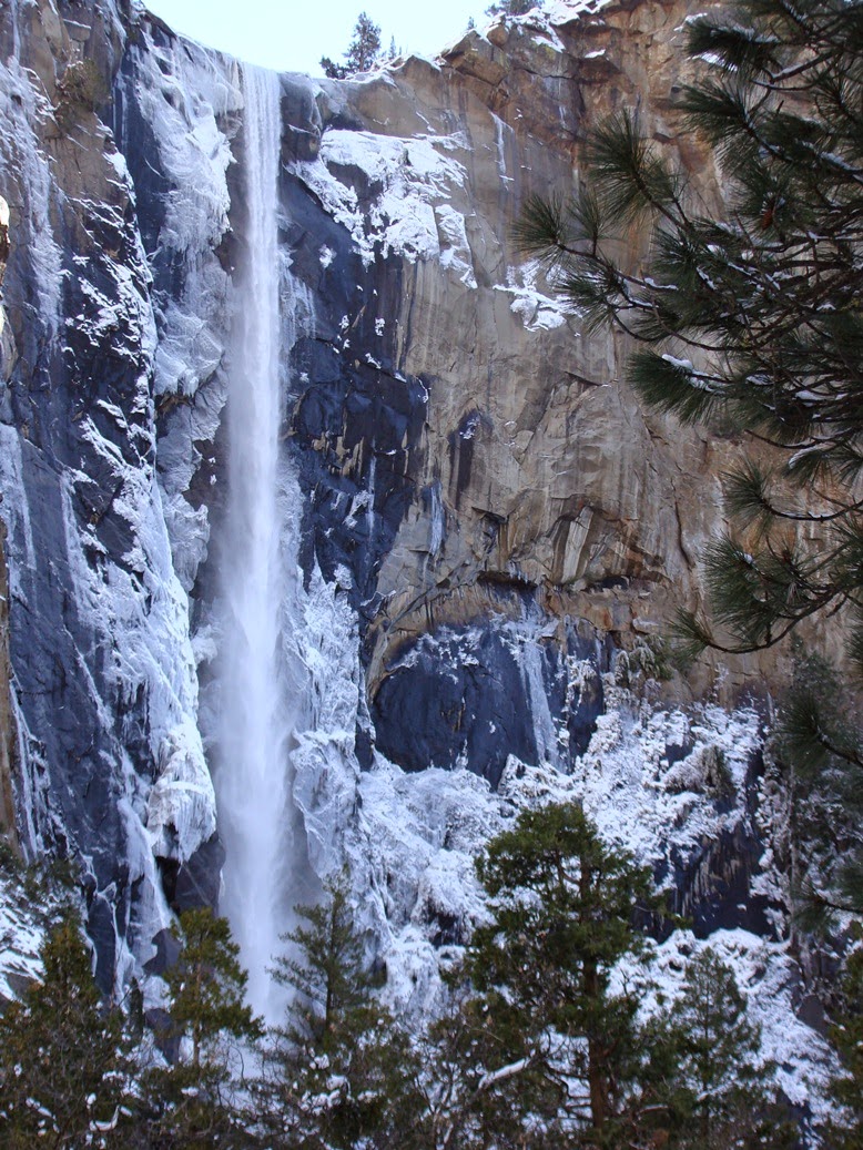
Bridalveil Falls under ice
This is turning out to be a season of hope, as the Sierra snowpack has reached 100% of normal for the first time in years. The El Niño weather pattern, the strongest ever recorded, has not yet exerted itself, but the warm waters of the Pacific Ocean have already added some oomph to the storms we've already. In 1997, we were hit with a series of incredibly warm storms that caused record flooding. We find ourselves hoping for a more measured series of storms that could fill our reservoirs without flooding.
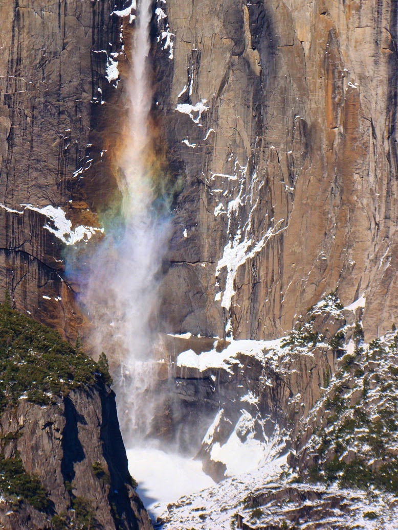
Upper Yosemite Falls with a rainbow
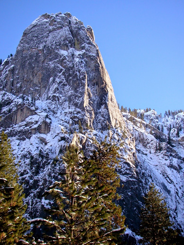
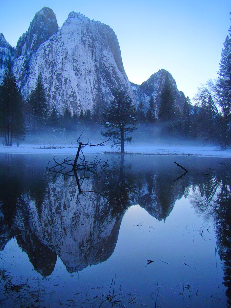
In the meantime, please enjoy these wintertime scenes from my treasured spot on the planet. Yosemite Valley is a place born of fire and ice, the "fire" from below that melted the crust into magmas that eventually became the granitic rocks, and the ice that helped to shape the stunning valley (the Merced River did most of the deepening of the canyon, while the ice sculpted the walls into their unique shapes and patterns).
Sentinel Rock in icy conditions
Yosemite Valley is just seven square miles (seven very famous square miles) in a park that has more than a thousand square miles. The park provides protection for the headwaters of the Tuolumne and Merced Rivers, both of which have carved spectacular gorges out of the granitic rock. Much of the park is roadless wilderness, but paved highways explore the Tuolumne Meadows and Glacier Point regions.
The Cathedral Rocks
Yosemite Valley, though, is a true treasure, with a striking combination of vertical cliffs, high waterfalls, quiet meadows (if you catch the right moment), and flowing rivers. I visit whenever I can, never once taking this incredible place for granted. It's one of the greatest gifts that nature has provided us.
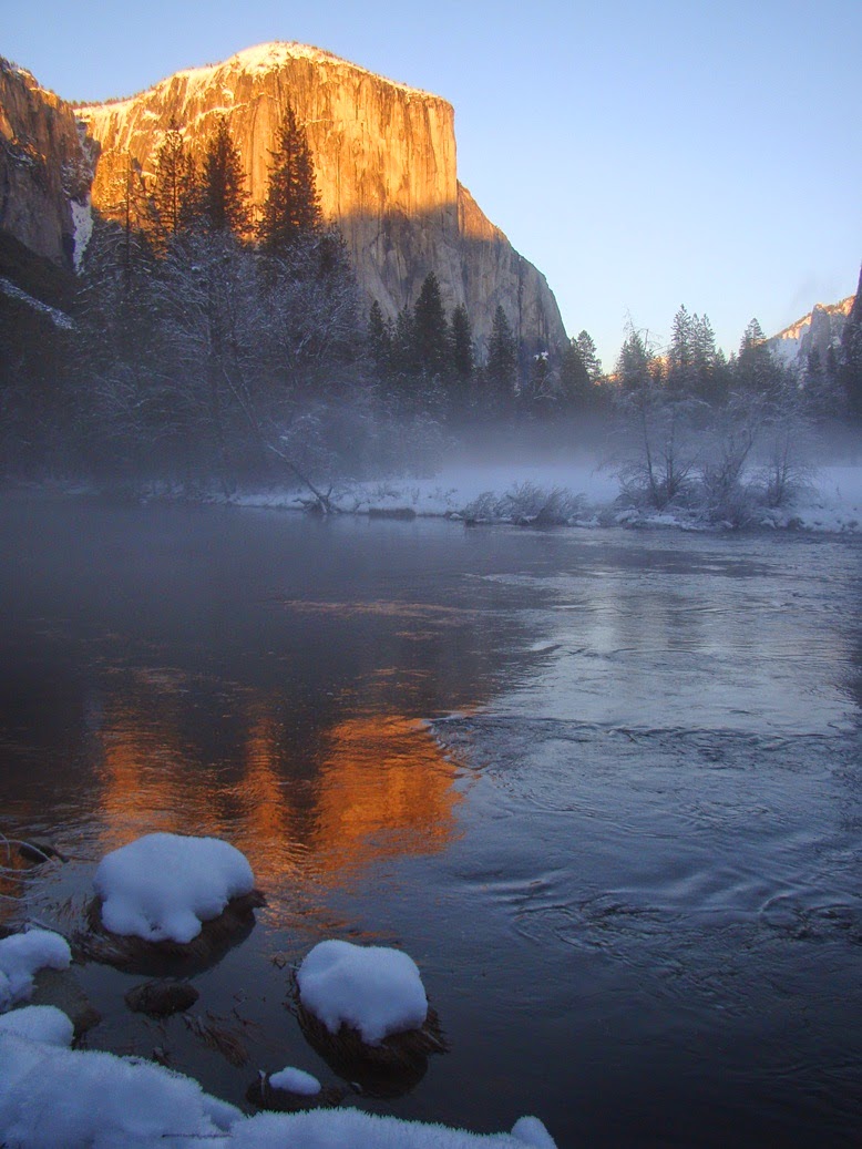
El Capitan
I want to thank all of my readers, new and old, for your attention and kind comments over the last seven years that I've been blogging. I've always enjoyed hearing from you, and appreciate getting to know my new friends from all over the world. I wish a wondrous season to you all!

Wednesday, December 23, 2015

The Airline Chronicles Briefly Return! Pacific Northwest Sights

Do you know what I like about flying? I admit that there is much not to like about flying, starting with navigating airports while dragging luggage, standing in security lines, paying $4 for a bottle of water, sitting in airplane seats designed for thin 12-year-olds, and waiting for baggage and rides at crowded airports. On the other hand, when one is at 36,000 feet, at that moment one is seeing a part of the world that no one else is seeing. And from rarely seen angles.
I don't fly as often as I would like, so I always keep my camera handy, since one never knows what might come up. A big storm had just hit the entire west coast, and clouds were everywhere as we flew towards the Pacific Northwest, so there wasn't much to see at first. But we were among the first people in California to the see the sunrise.
My phone GPS works in airplane mode, so I knew the very moment that I flew past Lassen Peak (covered by clouds), Mt. Shasta (under the plane), Crater Lake (under the clouds), and all the Cascades volcanoes of Oregon (under the clouds). A volcano finally rose above the clouds off in the distance. I thought it could be Hood, but I realized the only volcano tall enough that day was going to be Mt. Rainier, at over 14,000 feet in elevation. That's it in the first picture, after our descent towards Seattle, and in the picture above when we were still at a high elevation.
The biggest treat came when we approached SeaTac. I was on the right side of the plane, and a series of snow-covered peaks came into view through the windows on the left. Yes, I was silly enough to try to snap a zoomed shot through the window on the other side of the plane! The Olympic Mountains were shining bright in the morning sunshine, a sight no one on the ground could see that day. I didn't want to miss.
The planed banked to make its approach to the runway, and for a moment I could see the Olympics from my side of the plane as well. And then we descended through the clouds and the Seattle town center appeared through the mist. The Space Needle is hard to miss!

The Airline Chronicles was one of my first blog series, and I've returned to it on those rare occasions that I get to fly somewhere. The flight home is a nighttime flight, so it's going to be some time before we see another post in the series. Enjoy!

Sunday, December 20, 2015

Remembrance of the Past: A Great Valley Love Story, in Poetry


So it turns out I wasn't the only person writing words of love for my adopted homeland, the Great Valley of California. I write geology and environment words, and not poetry. But my home town of Modesto has a Poet Laureate. Her name is Gillian Wegener, and she recently penned a beautiful sonnet work about the valley that has been enshrined in our Great Valley Museum of Natural History at Modesto Junior College. The museum is a wonderful introduction to the natural world that lies hidden beneath millions of acres of agricultural fields and cities. There's a little bit left of the world from before, as those of you who've followed my blog would well know by now. So, please enjoy some poetry, as well as some scenes from my last few trips to the old world of our valley (the Merced and Sacramento National Wildlife Refuges)

Home


There is so much we will forget

And most of it doesn’t matter-

The grocery lists and the Tuesdays-

But we can’t forget that first

Our Valley was grassland,

Was riparian woodlands, was marsh,


Was peopled by those who knew

The places where the fish gathered,

Who knew the seasons of oaks,

Who knew the stories the stars told.

We cannot forget the way the wind,

Given its unimpeded way, ripples

The needle grass and the waters,

Moves them in the same rhythms.

And let’s not forget the calls of the cranes

Filling the air with a sound so dense

There’s almost no room for breath.


And we must remember too what’s already lost:

The grizzly, so much of the quiet marshlands…

Our world is poorer without them.

But the rivers still converge and

The beavers build their dams

And the hawks, ferruginous and red tail, drift

On the thermals, and all of this was happening,

Was here, before we were, before

Our grocery lists and our Tuesdays.


So we can’t forget the vernal pools

With their sudden flowers, and

Their patient species, buried and waiting,

Earthbound constellations of life mirroring

The constellations that shine above us


With stories we can’t forget, just as we can’t forget

That an earthquake in far off ocean makes waves

That flow, that propagate to our nearer shores,

That the moon’s gravity tugs at our wild oceans,

That our galaxy has wrapped its spiraling arms

Around our sun, that our sun is just one bright star

In a universe filled with bright stars,


The space between them expanding

Faster than we’d even imagined, and

We can’t forget, even as we’re learning,

Even as we are amazed at finding ourselves here

In this universe, in this galaxy, on this planet,

In this broad valley, with these creature, in this place

With its pockets of grasslands and woods

Which we won’t forget, which we will care for,

Because this is where we live, one of many species.

This is our shared and wondrous home.


A poem for the Great Valley Museum

January 17, 2015
 For more information about the Great Valley Museum, follow this link: http://www.mjc.edu/instruction/sme/gvm.