Wednesday, October 16, 2024

Why did the Road Cross the San Andreas Fault? 22 Years of Geologic Change (a new Update)

2002
I've been leading geology field studies trips to lots of places in the American West for 36 years and started to take digital pictures in 2001. I sometimes struggle to find new things to photograph when I visit a place for the 34th time, but in some cases it is not a problem. There are geologic changes that happen on a yearly basis, and with twenty-two years of photos (minus two due to Covid), the changes become obvious. This is a continuing update from a post in 2013, and I'll probably continue updating for the foreseeable future.
2004
Highway 25 in the California Coast Ranges connects the town of Hollister with the access road to Pinnacles National Park (formerly Pinnacles National Monument). Along the way the highway crosses the San Andreas fault in a section where the fault creeps an inch or so each year (36°35'54.27"N, 121°11'40.19"W). Most years we've stopped to have a look at the effect the movement has on the pavement. In 2002 and 2004, the damage was obvious.
2008
By 2008 someone had patched the road, and no fault motion was evident.
2009
Little damage was evident in 2009 either. But by 2010 cracks had begun to appear as the fault stressed the pavement.
2010
The fact that the fault creeps in this region is a good thing. It means that stress is not building along the fault surface, but instead is being released gradually. The sections of the fault to the north and south of the creeping section are locked by friction, and are building up the ominous stress that will eventually produce quakes with magnitudes in the range of 7.5 to 8.0. The quakes are coming and we need to be as prepared as possible.
2012
By 2012, the road had been completely repaved, and  yet the shearing was already evident.
2013
It became even more pronounced by 2013 and in 2014. Just by chance, the person working as a scale was the same individual as in 2004.
2014

In 2015 the fractures were moderately larger. They'll need to start thinking of road repairs before long.
2015
In 2016 Laura once again provided scale, as she did in 2014 and 2004.
2016
Here in 2017, long-time trip volunteer Mary provides scale. The cracks in the road are just a bit larger, but they didn't look appreciably different than the previous year except for a twist (pun intended).

2017
On Dec. 2, 2018, the break to my eye seems more continuous. It's now been six years since the road was completely repaved.
2018

Last year the paint was deformed (twisted), but not split (below).
2017
The offset paint strip reminds me of illustrations of elastic rebound theory, the idea that stress builds up on a fault line over time. In that model, the land on either side of the fault is distorted over time until the frictional resistance is overcome and the rock snaps back to its original shape. That won't be happening with the paint. Last year in 2017 I said "if they don't repair the road (as they often do; see above), it will probably show a clear break by next year." Here's what transpired:

First, a close-up on 2017's center stripe...
2017
And here's how it looked on Sunday, Dec. 2, 2018:
2018
As predicted, the break in the paint is complete...

In 2019 (those last few halcyon days before Covid) long-time volunteer Paul provided scale (he has been assisting MJC with field trips for 25 years!). The crack continues to grow, and I wouldn't have been surprised if it was patched by next year.
 The paint on the center strip is split even more.
November 2019
And then Covid happened and for a few years we were not able to conduct our field studies classes. In 2022 we made a return visit with our students and here is the then-current condition of the highway. It didn't appear that any repairs have been conducted yet. Our host is once again Laura, who was with us back in 2004 and subsequent years!
November 2022
Fault creep is not a constant. I didn't see a whole lot of change over the last three years, although I didn't get as many close-up shots. Here's a closer look with Paul, our other long-time volunteer. What do you see that is different?
November 2022
In 2023 the road continued to become more deformed, and the passing traffic produced an audible thump as it passed over the fault. Our host since 2004, Laura, was not able to join us, so her husband Ryan stood in her place.
Oct. 28, 2023
And now it's 2024, October 12 to be specific. Once again our guide is Laura, who has assisted on these trips since at least 2004. The crack continues with minor changes, and it may be overdue for another repaving job.
October 12, 2024
They may not have repaved the highway, but they did in fact repaint the center line, which obscures about two inches of right lateral offset.


These little changes that happen at a rate visible in human lifetimes add up to huge changes when multiplied by thousands or millions of years. The nearby eroded volcano of Pinnacles National Park has been displaced 195 miles (315 kilometers) in the last 20 million years or so by movement along the San Andreas.

Monday, October 14, 2024

A Second Look at Comet C/2023 A3 (Tsuchinshan-ATLAS)!

I had my first look at Comet C/2023 A3 (Tsuchinshan-ATLAS) last night, but my timing sucked, as I didn't locate it until it was close to the horizon and practically lost in the afterglow of the sunset. Tonight I was a bit better prepared, and the comet itself was higher in the sky. It was a beautiful sight, and the finest I've seen since 1997.
My phone is new and I've had little time to learn what it is capable of, but I was pleased with what I got tonight. I was focusing between 1x to as high as 6x magnification. I was also just able to see the comet with the naked eye, but it wasn't obvious.
Comet C/2023 A3 (Tsuchinshan-ATLAS) is getting higher in the western sky each night for the next few weeks, but it will also be growing dimmer as it gets farther from the sun. Get out and see it this week if you can, but if you can't, enjoy these pictures!


Sunday, October 13, 2024

Visible now! Comet C/2023 A3 (Tsuchinshan-ATLAS)


It's not often that I get to see two rare astronomical phenomena in the same week, but that's what has happened. The other night was an extraordinary display of the aurora borealis in my part of Central California (and most of the rest of the lower 48 states and Alaska). And tonight was my first look at a comet since 2020. Comet C/2023 A3 (Tsuchinshan-ATLAS) is now visible in the west shortly after sunset. It will be rising higher in the sky each night during the remainder of October, but it will be dimmer each night.
I couldn't see it with the naked eye, but the night-shot setting on my smart phone did a decent job of capturing the tail. A short internet search will reveal many spectacular photographs by people with better technology than me. A helpful providing the details of the discovery and location of the comet can be found here.
I've had a spotty relationship with comets over the years. Comet Neowise showed up in 2020, but my photos were not great. The two greatest comets I ever saw appeared in 1996 and 1997, about five years before I got any kind of digital photography equipment. I have great memories of comets Hiyakutake (1996) and Hale-Bopp (1997). They were truly spectacular, and Hale-Bopp was especially bright in the sky when I was crossing the deep dark skies of the Basin and Range province in the middle of the night on a long trip.

If you get a chance over the next few days, take a look west after sunset and see if you can't catch a glimpse of one of the fair treats of the cosmos.

Source: https://www.dailykos.com/stories/2024/10/13/2276491/-Comet-C-2023-A3-Tsuchinshan-ATLAS-is-now-visible-after-sunset?pm_campaign=front_page&pm_source=trending&pm_medium=web


Friday, October 11, 2024

Twice in 2024! Auroras in Central California

Back in May of this year, I saw something I had never seen before: the aurora borealis gracing the night sky over the prairie of the Sierra Nevada foothills. It was an astounding once-in-a-life event. Except it wasn't. The sun has been particularly active this year, and a coronal mass ejection occurred a few days ago that sent charged particles racing towards the Earth. For the second time in my life, I saw the aurora borealis from my home area.
I was teaching an online geology lab and happened across a report that auroras were being sighted in unusual places, and anxiously awaited for my students to finish their work. I checked out my front door and took a shot of the sky in the heavily light-polluted environment, and my phone camera caught the characteristic magenta-pink light. I talked Mrs. Geotripper into taking a late-night drive to the prairie-lands near Willms Road outside of Knight's Ferry on the Stanislaus River.
The lights were immediately evident in my phone camera pictures. They were very dim to the naked eye, but the night shot setting on my phone captured the detailed spires and structures in the lights quite well.
The intensity, color, and pattern of the light changed from moment to moment. It was a nice way to spend an evening!
The lights faded after about an hour and we went home. I hope you got a chance to see them, but if you didn't, please enjoy what we got to see!


The lights were not better or worse than those of last May. They were just different. It was a privilege to be able to view this gift of the cosmos.


Monday, August 5, 2024

Part 2: The Limestone Caves of Hawai'i - The Catastrophes at Makauwahi Cave


Makauwahi Cave and Sinkhole as it is today
I learned to my great surprise that Hawai'i has a few (very few, really) limestone caves. In part one I talked about the odd origin of Makauwahi Cave on the island of Kauai. In that post we learned that the limestone formed from limestone sand dunes that formed near Poipo Beach. The sand was lithified (glued together), and fresh water dissolved the limestone, forming the cavern, which has around 500 feet of passageways. At the end of the post I alluded to the fact that the cave was witness to three catastrophes that I'll look at today. On reflection, though, I think it's fair to say there were actually four catastrophes, one local, and the others island-wide.

Makauwahi Cave as it might have appeared 1000 B.C. Painting by Dr. Julian Hume
How did these catastrophes transpire? The rock formed around 400,000 years ago, and the passageways grew larger over time. By 7,000 years ago, wave action broke through and for perhaps a few centuries the cave was both a limestone cavern and a sea cave. Marine fossils formed a layer on the cave floor. But the waves may have contributed to the first catastrophe, because a short time later the roof of the cavern collapsed and formed a sinkhole. This is the bowl-shaped pit that is visible in the photo and painting above. The debris plugged the access to the sea, and the cavern and sinkhole filled with fresh water.

But is the collapse of a sinkhole a catastrophe? I guess it depends on your perspective. Some of the rarest of species on an island system with thousands of rare species would be those lifeforms adapted to living in total darkness. There are three blind species living in the darkness of Makauwahi Cave today, an amphipod, an isopod, and a blind spider (below) that feeds on the other two. These creatures have one of the most restricted environments possible on the islands, and the collapse severely restricted their living space. 

Blind cave wolf spider (descended from a surface-dwelling big-eyed spider, so it's sometimes called the no-eyed big-eyed Spider). Photo by Michelle Clark, USFWS.

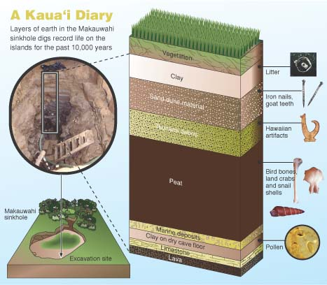
The real "catastrophe" is what followed the formation of the pond in the bottom of the sinkhole. Animals found their way into the pit, but no way out. The pit became a death trap. Over the next few thousand years huge numbers of fossils, both animals and plants, accumulated in the sinkhole. The organic rich mud (peat) grew to be one of the thickest layers within the pit (see below). Excavations since the 1990s have revealed thousands of specimens that have revealed more about the pre-human environment on Kauai than any other site on the island.

10,000 years of sediment, 33 feet thick, excavated at Makauwahi Cave Source: https://www.hawaii.edu/malamalama/2002/01/LostWorld.html
The primeval world of Kauai and the other Hawaiian Islands was unique. The islands are so isolated that no reptiles, amphibians, or mammals ever reached the islands (aside from seals and bats). The only vertebrate creatures that found their way to the islands were the birds. As a consequence, the environmental niches in the island ecosystem were filled by avian species, and over time they adapted and evolved to fully utilize the resources available to them. Species of hawk and owl filled the role of predator, especially of smaller birds. Ducks and geese grew to immense size and lost the ability to fly, given the lack of larger predators (see below). They took over the niche of plant-eaters and grazers. The honeycreepers were the most astounding example of evolutionary adaptation. From a single Asian finch-like ancestor, more than 50 distinct species evolved, filling the niches occupied elsewhere by parrots, hummingbirds, woodpeckers, and insectivores. Sadly, most of them are extinct and most of the survivors are critically endangered.

Every Hawaiian duck or goose here is now extinct, except for the Nene, on the right. The Nene almost went extinct in modern times. Source: http://www.cavereserve.org/resources/documents/slideshow.pdf
How unique is the Makauwahi fossil record? Of 107 bird species known to have been endemic to the Hawaiian Islands, nearly half (50 species) have been found in and near the sinkhole. Several species were found here and nowhere else on the islands. Some of the unique birds include a flightless goose, a turtle-jawed moa-nalo bird, a long-legged owl that probably fed on other birds, and a little duck with tiny eyes, a flat skull and tiny wings that probably fed on forest insects at night. Several of the birds like the hawk and Laysan duck no longer survive on Kauai, but are still found on other islands. 


Another catastrophe happened about 300-400 years ago. Excavators digging in the sinkhole found their way barred by a layer of boulders weighing as much as 200 pounds. These rocks were a mixture of basalt, lithified dune sands, and coral. The only process that could pile such debris in a sinkhole like this would be a huge tsunami. There must have been a village nearby because the deposit also contains some human artifacts like pieces of canoes, ropes, and ornamental objects. These rocks and other objects were carried over a ridge 27 feet above sea level, meaning the wave must have been much taller.

Humans in Hawai'i have always had to deal with the threat of tsunamis. The location of the islands near the center of the Pacific Ocean means that they can be hit by waves from all directions, generated by earthquakes in places as far-flung as Japan, Alaska, Washington, and Peru-Chile. Strangely, the largest tsunamis of all have been generated by the Hawaiian Islands themselves. Gigantic mega-slides from the flanks of the islands flowing onto the adjacent deep ocean floor have generated waves in excess of a thousand feet high! Thankfully, no such waves have occurred in historic time.


The biggest change at Makauwahi Cave was that the pond had been filled in and it was no longer a fossil trap. But the third and fourth catastrophes become visible in the sediment record of the cave: the arrival of human beings on the islands. 

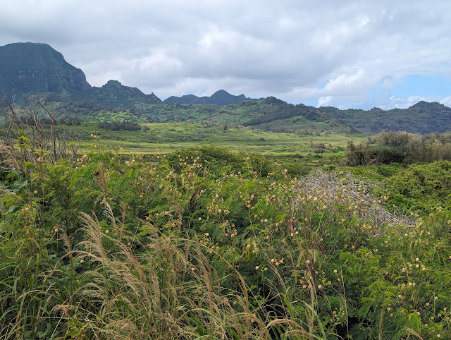
The landscape surrounding the sinkhole (above) is far, far different than the one that existed prior to a thousand years ago when the first Polynesians reached Kauai, the third catastrophe. Hardly any native vegetation remains. Humans have been successful at geo-engineering their environments to provide the food and resources they need to survive and flourish. The colonizers brought taro plants, coconuts, kukui nuts, and gourds, as well as dogs, pigs, chickens, and whether on purpose or not, the Pacific rat. These invasive plants and animals overwhelmed the native flora and fauna, driving many species to extinction, or to much more limited ranges.

Source: http://www.cavereserve.org/resources/documents/slideshow.pdf

The effect on the birds was truly catastrophic. Evolving in isolation, they had no defense against the mammal invaders. The flightless birds quickly disappeared, and many other species suffered huge declines (above).

Still, from a human point of view, a certain equilibrium had been achieved, even if the native species went into a steep decline. Humans had been expanding across the Pacific islands for centuries, and knew what resources they would need to bring with them when they found new islands to colonize. They also had a social structure that was rather efficient and strict (however unjust to our present sensibilities) that allowed the native Hawaiians to thrive in their new environment, largely operating within the carrying capacity of the lands they were occupying.

The fourth catastrophe began unfolding in 1778 when Captain James Cook and his crew arrived. The full extent of this event is also revealed in the sediments of Makauwahi Cave, but we'll take that up in part 3.

The authoritative source of information on Makauwahi Cave is the book Back to the Future in the Caves of Kaua`i: A Scientist’s Adventures in the Dark; David A. Burney, Yale University Press, 2010.