Saturday, November 19, 2022

Why did the Road Cross the San Andreas Fault? 20 Years of Geologic Change (a new Update)

2002
I've been leading geology field studies trips to lots of places in the American West for 30 years and started to take digital pictures in 2001. I sometimes struggle to find new things to photograph when I visit a place for the 30th time, but in some cases it is not a problem. There are geologic changes that happen on a yearly basis, and with twenty years of photos (minus two due to Covid), the changes become obvious. This is a continuing update from a post in 2013, and I'll probably continue updating for the foreseeable future.
2004
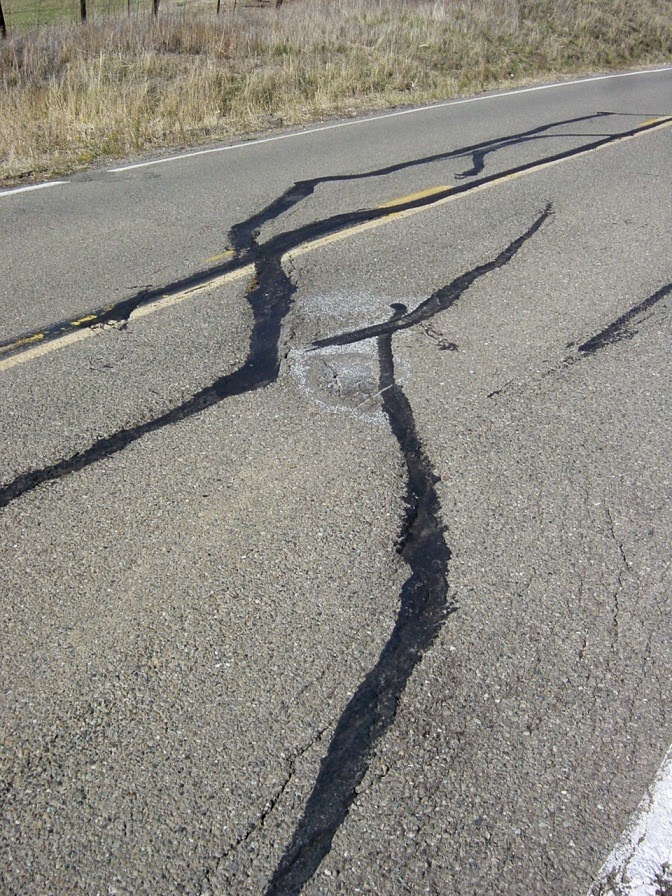
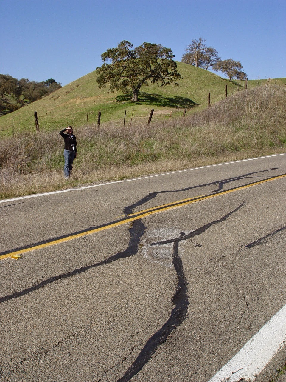
Highway 25 in the California Coast Ranges connects the town of Hollister with the access road to Pinnacles National Park (formerly Pinnacles National Monument). Along the way the highway crosses the San Andreas fault in a section where the fault creeps an inch or so each year (36°35'54.27"N, 121°11'40.19"W). Most years we've stopped to have a look at the effect the movement has on the pavement. In 2002 and 2004, the damage was obvious.
2008
By 2008 someone had patched the road, and no fault motion was evident.
2009
Little damage was evident in 2009 either. But by 2010 cracks had begun to appear as the fault stressed the pavement.
2010
The fact that the fault creeps in this region is a good thing. It means that stress is not building along the fault surface, but instead is being released gradually. The sections of the fault to the north and south of the creeping section are locked by friction, and are building up the ominous stress that will eventually produce quakes with magnitudes in the range of 7.5 to 8.0. The quakes are coming and we need to be as prepared as possible.
2012
By 2012, the road had been completely repaved, and  yet the shearing was already evident.
2013
It became even more pronounced by 2013 and in 2014. Just by chance, the person working as a scale was the same individual as in 2004.
2014

In 2015 the fractures were moderately larger. They'll need to start thinking of road repairs before long.
2015
In 2016 Laura once again provided scale, as she did in 2014 and 2004.
2016
Here in 2017, long-time trip volunteer Mary provides scale. The cracks in the road are just a bit larger, but they didn't look appreciably different than the previous year except for a twist (pun intended).

2017
On Dec. 2, 2018, the break to my eye seems more continuous. It's now been six years since the road was completely repaved.
2018

Last year the paint was deformed (twisted), but not split (below).
2017
The offset paint strip reminds me of illustrations of elastic rebound theory, the idea that stress builds up on a fault line over time. In that model, the land on either side of the fault is distorted over time until the frictional resistance is overcome and the rock snaps back to its original shape. That won't be happening with the paint. Last year in 2017 I said "if they don't repair the road (as they often do; see above), it will probably show a clear break by next year." Here's what transpired:

First, a close-up on 2017's center stripe...
2017
And here's how it looked on Sunday, Dec. 2, 2018:
2018
As predicted, the break in the paint is complete...

In 2019 (those last few halcyon days before Covid) long-time volunteer Paul provided scale (he has been assisting MJC with field trips for 25 years!). The crack continues to grow, and I wouldn't have been surprised if it was patched by next year.
 The paint on the center strip is split even more.
November 2019
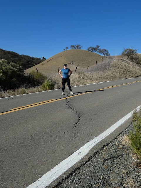
And then Covid happened and for a few years we were not able to conduct our field studies classes. Today we made a return visit with our students and here is the current condition of the highway. It doesn't appear that any repairs have been conducted yet. Our host is once again Laura, who was with us back in 2004 and subsequent years!
November 2022
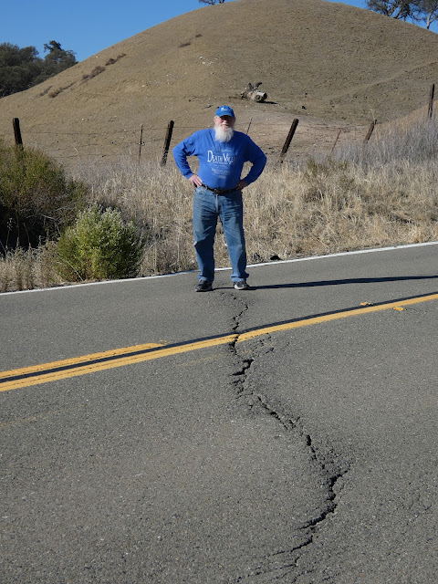
Fault creep is not a constant. I didn't see a whole lot of change over the last three years, although I didn't get as many close-up shots. Here's a closer look with Paul, our other long-time volunteer. What do you see that is different?
November 2022

These little changes that happen at a rate visible in human lifetimes add up to huge changes when multiplied by thousands or millions of years. The nearby eroded volcano of Pinnacles National Park has been displaced 195 miles (315 kilometers) in the last 20 million years or so by movement along the San Andreas.

Sunday, October 30, 2022

How It Was Today: Fall in Yosemite Valley

How it ended...

How it began...
I woke up late this morning. Mrs. Geotripper was finishing breakfast and asked if I'd like "to go up the river a little ways and find some fall colors". I had lots of grading to get through, so obviously I said yes, and around 11 or so we jumped in the car and headed up the Tuolumne River to see what we would find. There wasn't much, at least not in terms of fall color. So we went a little farther...
We followed Highway 132 up past Coulterville and on to Greeley Hill at a bit above 3,000 feet. Still not much in the way of fall color. So we went a bit farther up the hill and found ourselves at the Yosemite National Park entrance station at Big Oak Flat at 4,000 feet. We finally found a bit of color, although not at the intensity that a few more days of cold weather might bring. 
And we had made it this far, and Yosemite Valley was only 15 miles away. How could we pass it up? 
So on we went into the awesome gorge of the Merced River and into the valley itself. There was the first look at the distant cliffs of El Capitan (left), Half Dome (center), and Sentinel Rock and Dome (right).
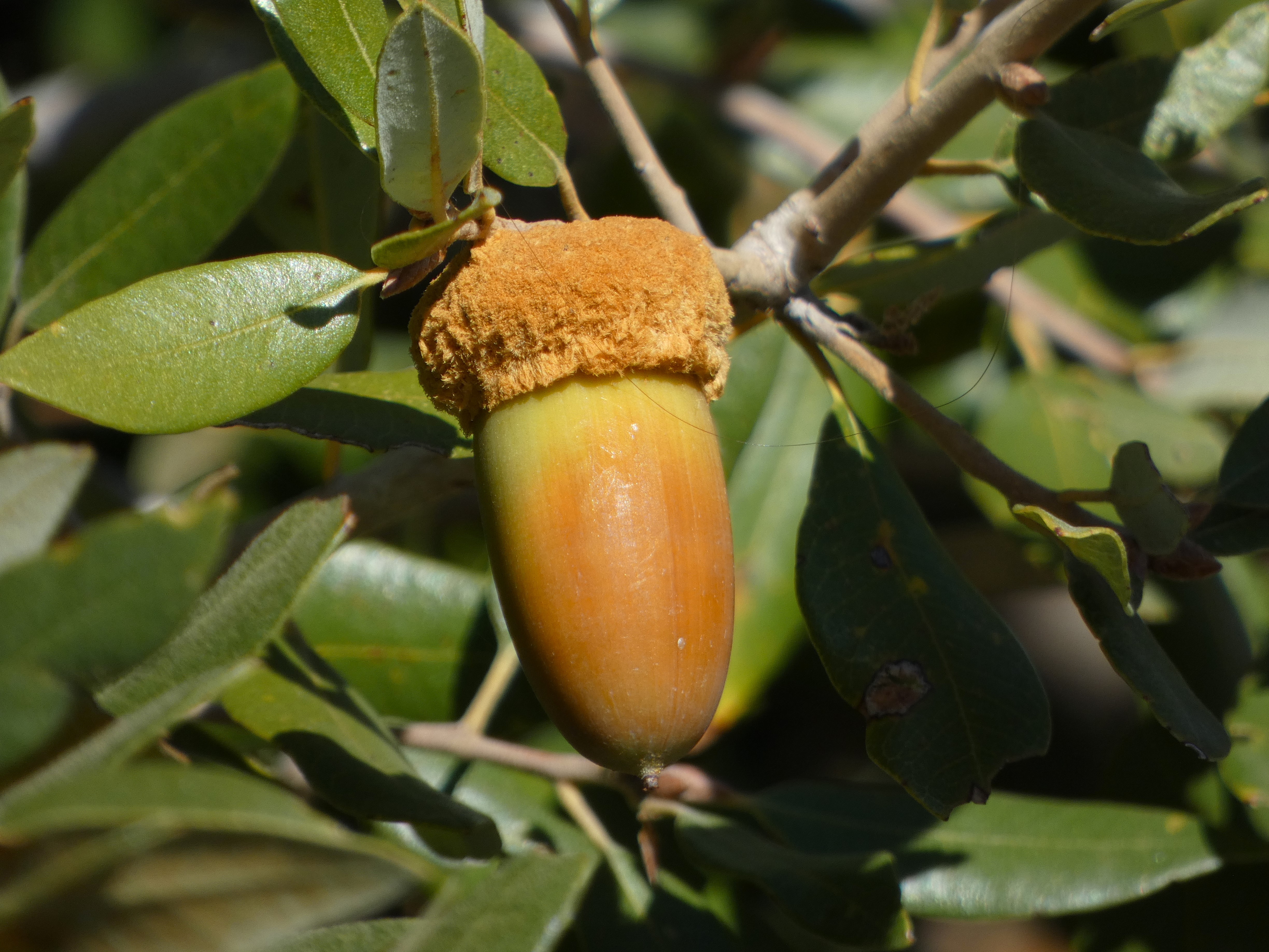
Closer at hand were a lot of ripening acorns. The bears and woodpeckers will be happy.
We reached the valley floor and started our tour of Yosemite's greatest hits. We were surprised to find some wispy curtains of water flowing over Bridalveil Falls. The 620 foot-high waterfall is a classic example of a glacial hanging valley. The main trunk glacier flowing through Yosemite Valley was able to erode a much deeper trough than the small glacier in Bridalveil Creek, so the floor of the creek was left hanging high above the main valley floor.
It was not a cold day, mostly in the sixties, but the sun was intense. It brought out what colors there were in the oaks and dogwood trees.
We didn't see a great many varieties of birds, but there were some Acorn Woodpeckers busy collecting acorns and hiding them in tree "granaries". Such trees can have tens of thousands of drilled holes that can hold a single acorn each. The birds live in loose family groups who search for and guard their food supplies.
Yosemite Valley is not a 'typical' glacially-carved valley. Most such valleys have a U-shaped profile, and are relatively straight. Yosemite Valley is characterized instead by bold cliffs that extend out into the valley with dark recesses in-between. This is the result of having eight distinct intrusions of granitic rock, ranging in composition from 'true' granite to granodiorite, tonalite, and diorite. They differ from each other in the proportions of the minerals quartz, potassium feldspar, and plagioclase. They also vary in the amount of dark minerals they contain including biotite mica, hornblende, and a little augite. They also vary in their pattern of fracturing (jointing), and this is expressed in differing vulnerability to erosion by ice, water, and mass wasting (landsliding and rock falls).
Sentinel Dome (above) is a good example. It is composed of fairly resistant Sentinel granodiorite, but it is jointed and thus forms a somewhat narrow high cliff that looms over the valley.
Yosemite Point on the other hand is composed mostly of unjointed El Capitan granite and forms a wide bold cliff. Sometimes people sort of 'miss' this incredible cliff because much of the time there is a stunning waterfall pouring off the west flank of the precipice (the dark mark on the left side in the picture below). That waterfall is only fifth or seventh highest waterfall in the world, and is known by the moniker of Yosemite Falls, measuring in at 2,425 feet. It wasn't actually dry today, but one needed binoculars to see the small trickle at the top of the cliff.
The autumn season is one of the best times to view Half Dome from the middle of Sentinel Bridge. The Merced River is flowing at a low ebb and the still waters make for memorable reflections. Half Dome is another example of an unjointed monolith of granitic rock called the Half Dome granodiorite. It is the youngest of the igneous intrusions exposed in the valley, with an age of about 84 million years. The Sentinel granodiorite is about 88 million years, and the El Capitan granite around 103 million years. These dates fall within the Cretaceous period, which means that when these molten masses were intruding the crust, there were dinosaurs wandering the surface four or five miles above. The dinosaurs would have experienced occasional volcanic eruptions when some of the intruding magma escaped to the surface.

In the years since, erosion has removed the miles of overlying rock and dumped it into the Central Valley or the waters off the coast of ancient California. The region seems to have been eroded to a low elevation landscape that was later uplifted to form the modern Sierra Nevada.
We wandered around Cook's Meadow and stopped into the store at Curry Village to replenish my t-shirt collection. The sun was starting to get low, so we made our way west to our favorite evening viewpoint, Valley View.
Valley View is almost a secret to Yosemite visitors because it has a small parking lot (maybe room for ten cars) at a blind curve so that if you are in the right-hand lane you might miss it. Since the road is one-way at that point, you would have to repeat a five mile loop to get back. The small parking lot is a blessing because it limits the size of the crowd. It's a quiet spot to enjoy the fading light on the cliffs of El Capitan and the Cathedral Rocks. The river usually flows slowly here making for memorable reflections of the cliffs above. We enjoyed the few moments of peace, and then headed home.
And that's the way it was today...
 

Monday, September 19, 2022

The Other Yosemites: The Treasured Valleys of the Sierra Nevada

"Yosemite is so wonderful that we are apt to regard it as an exceptional creation, the only valley of its kind in the world; but Nature is not so poor as to have only one of anything. Several other yosemites have been discovered in the Sierra that occupy the same relative positions on the Range and were formed by the same forces in the same kind of granite." John Muir, The Yosemite, 1912 
It may very well be that there is no place on Earth quite like Yosemite Valley. Few places can combine such dramatic cliffs and peaks with impossibly high waterfalls and deep forest glens. It remains one of my favorite places to visit, and it is one of life's great pieces of luck that I live only a 90 minute drive away. I go whenever I can. 


There is, however, an unfortunate truth of Yosemite Valley: here, like at Arches, Zion, Glacier, Yellowstone, and Grand Canyon, we are loving our national parks to death. The crowding in Yosemite Valley can be abysmal, only relieved to some small extent by the rationing of entrance reservations. I remember the nightmare of visiting the park on a Labor Day weekend (the family members who were seeing it for the first time could only get away at that time). We spent nearly the whole time in a traffic jam, finally scoring a parking spot at Curry Village for a while. And then a long traffic jam getting back out of the valley. The family with us treasured the experience of at least seeing the soaring cliffs, but really, this is no way to enjoy our national treasures.  


When it comes down to it, we have a choice. We can continue to ration these precious places more and more, or we can expand the idea of what is spectacular and convince people that there are places of awe that can also be places of serenity and wonder. Without the crowds. John Muir, one of Yosemite's greatest fans, understood this well. In his writings, he was constantly reminding us that the Sierra Nevada is full of spectacular canyons, which he called the "other yosemites".

Source: Herbert Gleason (1920s), in Wikipedia
One of those places is so remote that I expect that I will never have the chance to see it personally. I'm a bit too old I think to make the long trek of 10-plus miles followed by a precipitous plunge down thousands of feet of switchbacks into Tehipite Valley on the Middle Fork of the Kings River. And it doesn't have just a half a dome; it has a whole one, Tehipite Dome, which towers 3,500 feet above the forested valley floor.

Amazingly, the valley was proposed as a site for a reservoir despite its remote location. When Kings Canyon was made a national park in 1940, Tehipite Valley was purposely left out of the park boundaries on the expectation that the dam would be built. It wasn't until 1965 that the valley was incorporated into the park.

Source: Grand Canyon of the Tuolumne, by Matt Hoffman through Wikipedia

I have stood at the portal of one of the other yosemites, the Grand Canyon of the Tuolumne River. When I was a teenager, my family backpacked to Glen Aulin Camp at the upstream end of the gorge, but we didn't go any further downstream. I still have hopes of hiking out to the rim of the canyon from White Wolf in Yosemite.

The canyon is as deep as the Arizona version of the Grand, but could hardly look more different. The canyon has been shaped by the longest most extensive glacier that ever existed in the Sierra Nevada. While Yosemite is famous for high waterfalls that leap from the canyon rim, the Tuolumne is noted for the large waterfalls on the Tuolumne River itself, especially Waterwheel Falls, where the river leaps upward into the air during periods of high flow.


One of the most famous "other yosemites" was Muir's most treasured valley, Hetch Hetchy, which is downstream of the Grand Canyon of the Tuolumne. Parts of Hetch Hetchy bear a startling resemblance to Yosemite, with a rectangular cliff that resembles El Capitan, and a pair of stunning waterfalls, Wapama Falls, at 1,080 ft (330 m), and Tueeulala Falls, at 840 ft (260 m).
Unfortunately, Hetch Hetchy was deemed an ideal spot for water storage, and after a protracted political battle in 1914, O'Shaughnessy Dam was built and flooded the entire valley floor under 300 feet of water. It was at the time within the boundaries of Yosemite National Park. Muir's heartache over the loss was said to have contributed to his death. 
Access is much easier at Hetch Hetchy, as a paved road reaches the valley and dam from the Big Oak Flat Entrance to Yosemite National Park. There are trails that reach the base of the waterfalls and on into the backcountry, but Hetch Hetchy receives a very small fraction of the visitation that Yosemite gets. It should have been different. There are constant calls for the dismantling of the dam, but it would be decades before the valley could become what it should be. When I photograph the valley, I tend to crop out the lake...
John Muir wrote of another yosemite in a magazine article in 1891:
In the vast Sierra wilderness far to the southward of the famous Yosemite Valley, there is a yet grander valley of the same kind. It is situated on the south fork of King's River, above the most extensive groves and forests of the giant sequoia, and beneath the shadows the highest mountains in the range, where the cañons are deepest and the snow-laden peaks are crowded most closely together. It is called the Big King's River Cañon.
Today we call it the South Fork of the Kings River, and the valley floor Cedar Grove. It is more accessible than all the others, with a paved highway, four or five campgrounds, and a small resort and store. But most importantly, it offers a quiet experience in a spectacular setting. I've rarely seen crowds here, although I'm sure it happens. But never on the scale of what goes on in Yosemite Valley.
There is a network of trails throughout the valley, and trailheads lead into the alpine country above (some of them insanely steep). But most of all, it offers high granite cliffs that tower over the valley floor. They aren't the same as Yosemite's cliffs, nor should they be. But they are just as high and are truly awesome in their own right.
It's a sad commentary on human values that this incredible valley was also slated to become another reservoir, and like Tehipite Valley it was left out of the boundaries of the new Kings Canyon National Park in 1940, and was not added to the park until 1965. Because of this wise decision, we have a beautiful alternative to the crowded madness of a summer day in Yosemite Valley.
Come and see Yosemite Valley, of course. It is the experience of a lifetime. But give yourself some time to see the other less famous yosemites. If you can, walk to the remote valleys. Take lots of pictures for the benefit of those who can't (I would love to post an entire blog entry of anyone's journey into Tehipite Valley). You won't be disappointed, and all you'll miss is the traffic and the unruly masses of humanity.


Sunday, August 21, 2022

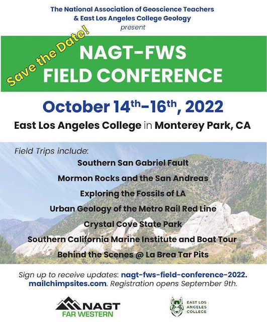
The National Association of Geoscience Teachers, Far West Section holds first post-pandemic field conference in Southern California, Oct. 14-16, 2022

The Far West Section of the National Association of Geoscience Teachers is offering the first field conference since the beginning of the pandemic! It is open to non-members and friends of geology. It looks like a great line-up of field trips in Southern California!

The NAGT and the Far Western Section exist to help teachers of the earth-related sciences. Part of our mission is to increase the expertise of our members (and friends) in the geology of their home regions, and our past meetings have been held all over California, Nevada and Hawaii. The conferences usually include the field trips, a field guide, and featured speakers. It's a great way to meet other teachers as well. My personal journey as a teacher has been deeply impacted by my participation in these events over the last 25 years. 

Check it out! We would like to get many new faces as we renovate the organization in a post-pandemic world. We hope to see you there! For announcements and updates, sign up at the link above.

Monday, July 18, 2022

What Makes a Canyon Grand? And How Deep is Deep? Exploring Kings Canyon, One of the Deepest Canyons in North America

Well, let's jump right into it. The picture above is Spanish Peak in the Sierra Nevada, which looms above the canyon of the Kings River. The peak tops out at 10,051 feet (3,064 meters). The drainage on the left is Rough Creek, and it enters the Kings River at an elevation of about 1,800 feet. The drainage on the right is Deer Creek, and it enters the Kings at about 2,300 feet. This seems to indicate a depth of Kings Canyon as between 8,200 and 7,700 feet, depending on where you choose to define it. 

So, what of it? 

If you search for "the deepest canyon in North America", the honor seems more often to be given to Hells Canyon on the Snake River on the border between Oregon and Idaho. The depth often given is the difference between He-Devil Mountain and the river at 7,993 feet (2,436 meters). Or 8,043 feet (2,452 meters). Or 7,913 feet (2,411 meters).  

So, the designation of "deepest canyon" seems to be somewhat in conflict. The argument can be muddied by pointing out the canyons are asymmetric, and that the other sides of the canyons are less dramatic in height. There is some truth to this, as the south slope at Kings Canyon tops out at just over 7,000 feet, meaning that the canyon is only a little over 5,000 feet deep. But the problem is similar for Hells Canyon, where the ridges across the river are just over 5,000 feet above the river. 

Which is deepest? I don't know, and I don't particularly care. If Idaho needs to have the 'deepest' or 'biggest' of something, they can have it. After all California has lots of superlatives, like biggest living things, tallest trees, oldest living things, tallest mountain in the lower 48, and so on. I've not been to Hells Canyon. But I have been to Kings Canyon, and what I do know is that it is one of the most spectacular places on Earth.

The upper reaches of Kings Canyon include some of the highest and most rugged parts of the Sierra Nevada crest. Parts of the Middle Fork are too precipitous for roads or even foot trails. These parts of the canyon are protected as Kings Canyon National Park, established in 1940. a full fifty years after the designation of Yosemite as a national park. One of the most pleasant parts of the canyon, Cedar Grove, was left out of the park because of plans to inundate the valley under the waters of a reservoir. Better angels prevailed and Cedar Grove was added to the park in 1965. The downstream (and deepest) part of the canyon is administered by the U.S. Forest Service.
As rugged as the canyon is, a paved highway (Highway 180) provides access to Cedar Grove, and it is pretty incredible to drive. I marvel at the engineering decisions that went into the design of the present-day highway. The terrain is literally impassable, but someone decided where the road would go, and laborers blasted away at the rocks. Most of the construction crews were prisoners. The road was planned as early as 1905, and construction took place during the 1920s and 1930s. At one time it was envisioned that the road would continue up and over Kearsarge Pass to connect with Onion Valley. Thankfully that plan didn't come to fruition. 

The highway passes through some astounding geology. Granitic rocks may make up most of the Sierra Nevada, but Kings Canyon contains exposures of some large metamorphic roof pendants of Paleozoic and Mesozoic age. A stunning cliff of gray marble forms one wall of the South Fork, and contains a number of caverns, including the developed tourist attraction of Boyden Cavern. Quartzite, slate and spectacularly folded calc-silicate rocks are also exposed along the highway.

The viewpoints along the highway just north of Grant Grove are simply beyond compare, giving a full-on perspective of the deepest part of the gorge as well as vistas towards the high country near the Sierra Crest. And...it is a LOT less crowded than Yosemite Valley!

In case you were wondering about other deep canyons, the Sierra Nevada hosts numerous awesome gorges. The Grand Canyon of the Tuolumne River is a roadless part of Yosemite National Park which in places is fully as deep as the Grand Canyon at 5,000 feet. I would love to offer pictures, but I haven't traveled through it in many decades. Another canyon, that of the Kern River in Sequoia National Park, is 7,000 feet deep in places. Yosemite Valley is a mere 3,000 feet deep, but with those vertical walls it truly stands apart as one of the unique places of the planet.

Farther afield, Mexico has the Barranca del Cobre (Chihuahua, Mexico). The canyon system has six major gorges, of which Urique Canyon is the deepest and largest, measuring at one point 6,236 feet deep.

The deepest canyon I know of in Polynesia is Waimea Canyon on the Hawaiian Island of Kauai. It is sometimes called the "Grand Canyon of the Pacific", but I think it stands pretty well by itself without having to compare it to others. It is a favorite destination of mine when I visit the islands. It is nearly 3,000 feet deep in places.

Waimea Canyon on the island of Kauai in Hawaii

In South America, the deepest canyon I could find info on was Colca Canyon in Peru. At one point it is 13,600 feet deep. 

The ultimate canyons would pretty much have to be where the mountains are the highest, so the deepest canyon in the world is found in the Himalayas. Some of the canyons that pass through the range (the Kali Gandaki or Yarlung Tsangpo Gorges for example) are said to reach depths of 17,000-19,000 feet.

And finally, since it was part of the title, there is the Grand Canyon of Arizona. It's not the deepest canyon overall, but it does maintain a consistent depth of over 5,000 feet for several hundred miles, and there is no canyon like it in the world. I can't even describe how spectacular it is in a few sentences, so I offer the blog series I wrote after a memorable river trip in 2013 in which I almost died, twice, but also had the greatest adventure of my life. Check out Into the Great Unknown