Showing posts with label gneiss. Show all posts

Saturday, September 6, 2014

Northern Convergence: A Different Kind of Convergence More Than a Century Ago in Craigellachie


There was a time in this fair land when the railroad did not run
When the wild majestic mountains stood alone against the sun
Long before the white man and long before the wheel
When the green dark forest was too silent to be real
Canadian Railroad Trilogy - Gordon Lightfoot

As we crossed the mountains of British Columbia on our geological journey through western Canada, I was becoming aware that whenever we stopped I seem to hear trains in the distance. It makes sense; in mountainous country, highways tend to follow railways, which were sometimes constructed along ancient trails, which followed the gentlest passes. Railways had a somewhat special role in the settlement and development of North America. Completion of the railway across the United States, culminating in the ceremony of the golden spike at Promontory Summit, Utah in 1869 transformed travel across the country. It turned overnight from an arduous dangerous journey of months by horse, oxen, and foot, to a comfortable ride of several days.

The construction of the transcontinental railroad was a huge accomplishment, crossing the prairies, the Rocky Mountains, and Great Basin, and the Sierra Nevada. It was one of the more significant events in U.S. history. But on our journey through Canada, I began to wonder if there hadn't been an even more impressive event north of the border.
We pulled into Craigellachie at the border of the Shuswap Highlands and Monashee Mountains. We were visiting the small park commemorating the driving of the last spike of the Canadian Pacific Railroad in 1885. Having just come through hundreds of kilometers of rugged mountainous terrain, we could understand why the "last spike" was so far to the west. The explorations and route planning of the architects of the railway must have been challenging to say the least.  For one, there was the winter. Many of the high passes presented special challenges from avalanches, or spring flooding in the river canyons. Farther to the east, the railroad had to pass through kilometer after kilometer of muskeg, the soft spongy swamplands of near-Arctic landscapes.
A monument to the last spike was erected at the centennial in 1985. We noticed that there is no lack of activity on the rail line, as at least five trains barreled through during our short visit (including the one above; the picture doesn't give the sense of motion, but it was moving fast).
I couldn't help but notice in the commemorative painting of the driving of the last spike that the person driving the spike was a dignitary who I suspect had rarely lifted a hammer in his life. It's not that I bear any animosity towards him (his name was Douglas Smith, a main financial backer of the railway), and in fact he was quite a philanthropist. But why is it that the dignitaries always get to shovel the first bit of dirt on a major project, and then let thousands of hard-working and hard-living workers (the "navvies") struggle for years to complete the project? Then, when the job is done, they come back and pretend to do a hard thing like driving the last stake? I guess it would be too much trouble to remember the names of the navvies, especially the ones who gave their lives in the service of the railways.
The centennial monument had something interesting on the flanks: representative rock samples from each of the Canadian Provinces. Above is a piece of anorthosite from Newfoundland. Anorthosite, a plutonic rock containing a large proportion of plagioclase feldspar and a few dark minerals, is known mostly from very ancient rocks, generally a billion years or older. It was also found on the Moon, making up the lunar highlands.
The Saint George granite out of New Brunswick is another plutonic rock that apparently is an excellent construction stone that has been quarried for years. It is Devonian in age, about 380 million years old.
The granitic gneiss from Wollaston Lake in Saskatchewan is an ancient rock, around two billion years old. The region has produced uranium.
British Columbia provided a chunk of jade from Mount Ogden. The jade is representative of rocks that formed in a convergent plate setting under great compressive stresses. Jade is of course valuable as a semi-precious gemstone. The outcrops are associated with exposures of serpentinite, a rock we are familiar with back home in California.
The visitor center offered up a chance to pound stakes into a railway, though I had more fun using their equipment as a rock hammer...

One of my favorite songwriters of all time, Gordon Lightfoot, wrote a song commemorating the centennial of the building of the railway, the Canadian Railroad Trilogy (the first stanza is quoted above). I like how he honored the navvies, those who did the actual work (the song was the first place I ever came across the word). Here is a YouTube of his performance of the song in Reno in 2000. Enjoy!


We are the navvies who work upon the railway
Swingin' our hammers in the bright blazin' sun
Livin' on stew and drinkin' bad whiskey
Bendin' our old backs 'til the long days are done

Thursday, March 20, 2014

Out of the Valley of Death: Mountains Hidden Within Mountains

I don't think there's anything nicer for a teacher of the earth sciences than to have a classroom in the outdoors. The planet is always around us and to step outside a classroom is to step outside of book learning and theoretical constructs, and into the actual chemical and physical reactions that affect every aspect of our lives. Yes, there is always gravity, and we are always respirating whether we are indoors or out, but there is nothing quite like being right on top of the volcanoes or the faults that can cause geological mayhem. We can tell the story of how rocks and mountains and continents came into being, but it is something else entirely to stand on the rocks that actually tell us the story step by step. There is just no substitute for field experience in a geology class.

So here is our class sitting in the midst of one of the greatest geological parks in the world, Death Valley. Rocks from nearly all the periods and eras of the geological time scale can be found within the boundaries of the park, and the park includes some of the oldest rocks in western North America (one has to get to Montana and Wyoming to find rocks that are older). They are quite literally sitting on the trace of a major fault line, and the darker slope on the left is a small volcanic cone that erupted along the fault. It's all the geological mayhem in one spot than anyone could ask for!
We had spent the day working our way through geological time, with a stop at a roadcut containing Miocene tuff and examples of faulting, a stop on the alluvial fan below a mountain of Paleozoic-aged fossil bearing limestone, and an exploration of a former rift valley containing late Proterozoic sediments. We had now reached the base of the Black Mountains of Death Valley, the deepest crustal rocks exposed anywhere in the park. They are exposed here because extreme extensional forces have  ripped the crust apart, and the deep trough of Death Valley gives us a peek into the deeper parts of the continent. These are rocks from the early Proterozoic around 1.7 billion years ago. The radiometric age date of 1.7 billion years records the time that these rocks were metamorphosed, so the actual age of the protoliths (the original rock before metamorphism) is millions of years older still. There are hints of rocks and detrital grains (the Mojave Block) that may be as old 2.3 billion years, more than half the age of the Earth.
A look at the rocks where they spilled out onto the valley floor offers a hint of the massive changes these rocks have experienced. They are composed of gneiss and schist, rocks that normally develop in regions of extreme temperature and pressure deep in the crust. About the only geological circumstance in which such conditions occur are in places where continents or exotic terranes are colliding with each other, in the way that India is colliding with Asia today to form the Himalaya Mountains. Such a mountain range once existed right here. And it eroded away, almost completely. Then, the continent split, and a portion of the ancient mountain range rifted away to become part of Australia and/or Antarctica. The remainder of the rocks were buried under tens of thousands of feet of younger sediments during the Paleozoic era. And there they remained for several hundred million years.

It wasn't until intense extensional forces ripped the crust apart, causing the graben of Death Valley to sink and form the imposing western face of the Black Mountains. As the mass of the overlying rocks slid off the deeper crustal rocks, the deep rocks domed upwards to form the curving footwall of the strange "turtlebacks" of Death Valley. In other words, the roots of an ancient mountain range rose to form the core of a modern day range, the Black Mountains: mountains hidden with mountains.
And the drama was visible within the rocks we were sitting on. It was a most amazing classroom!

Wednesday, December 28, 2011

Dispatches from the Road: Feeling Detached in Saguaro National Park

Had a few spare moments from family matters while in Tucson, Arizona today, so we headed out to Saguaro National Park and Tucson Mountain Park, which are both on the outskirts of the city. I'm not overly familiar with the area's geology, so it was a real learning experience. I really wish I had more time here!

The first thing that happened is that this mockingbird got in the way of my picture of the far mountain ridge. There was a beautiful bright red cardinal, too, but I couldn't convince it to block the scenery for me...
The Saguaro cacti kept getting in the way of the shots of the rocks, too, but I guess they provide some sense of proportion. The mountain ridges in the Rincon District of Saguaro National Park looked vaguely familiar to me, forming a roughly domal shape.
A convenient pull-out confirmed my suspicions...these rocks were reminding me of Death Valley...specifically the Black Mountains on the east side where several detachment faults are prominently exposed. Detachments are evidence of extreme extensional forces in the crust of the Earth. As the younger overlying rocks slip off the underlying ancient rocks, the rocks bow upwards forming the dome-like outlines. Deeply deformed rocks called mylonite are found along the fault contacts
The younger overlying rocks actually ended up on the other side of the Tucson valley. They make up the rocks exposed in Tucson Mountain Park, which we visited briefly while looking for a place to watch the sunset. Much of the rock is volcanic rhyolite, formed during intense caldera eruptions similar to those that produced Yellowstone and Long Valley (in California). The sharply jointed rocks form prominent peaks that do a nice job of catching the last rays of the sun.
 I am almost never disappointed by an Arizona sunset...
The Saguaros always provide a nice frame for pictures of the sky and horizon...almost a cliche that you've seen a thousand times in calendars, but there is nothing like being there. I couldn't stop snapping pictures, and if I didn't have a camera, I would have sketched. And if I didn't have a sketch pad, I would have scratched images on the rock, much as the original inhabitants of this country did thousands of years ago. It's that pretty.
From Gates Pass, the view was stupendous. We watched until darkness, and headed back down into Tucson for dinner. Gotta get some sleep, because tomorrow we are headed to the Grand Canyon! To research the summer field trip, of course....
For some information on the geology of Saguaro National Park and the adjacent Tucson Mountain Park, check out this pdf file.

Wednesday, November 9, 2011

Vagabonding across the 39th Parallel: A Canyon Where Cameras Stand Sideways

You walk to the edge of the precipice, and you lose all sense of proportion. The rocks at your feet drop off in vertical cliffs into the darkness nearly 2,000 feet below. The opposite rim seems close enough that you are tempted to try and throw a rock across (but it is more than a thousand feet away).  You have never seen a canyon quite like Black Canyon of the Gunnison.
It didn't take some of you very long to figure out where we were in the last vagabonding post; I was describing a place that could have been the much more familiar Grand Canyon National Park, a place with a less visited North Rim, and a heavily trafficked South Rim, but we were in Colorado instead. Black Canyon of the Gunnison National Park preserves one of the most unique canyons in the world, a canyon so deep that cameras start standing sideways in the hands of photographers leaning over the rim. The canyon just doesn't fit in the picture any other way.
The canyon seems impossibly steep. The walls are made of extremely tough metamorphic gneiss and schist, intruded by dikes and sills of equally tough granite pegmatite (an extremely coarse-grained variety of granite; many of the crystals of quartz, feldspar and mica are more than an inch across). The rocks are some of the oldest to be found anywhere in the western United States; they date to Proterozoic time, around 1.7 billion years ago.
 A canyon that in many places is deeper than it is wide. It defies belief.
The Painted Wall is the highest unbroken cliff in Colorado with a drop of more than 2,000 feet. The gneiss and schist exposures are dark, while the pegmatite dikes are lighter in color. The rocks record a complex story of continent-terrane collisions, intrusions and mountain-building episodes. The rocks on the rim preserve a relatively flat surface representing a profound amount of erosion...many vertical miles of rock are missing, having been converted into an unimaginable mix of pebbles, sand and mud distributed by rivers that long ago ceased to exist.
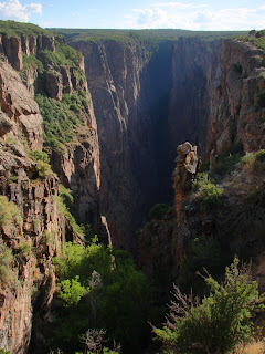
The very existence of the canyon is a handy mystery. It carves through what is essentially the top of a mountain ridge, and looking at maps, it looks like the river should be flowing someplace else. One has to drive a long way uphill to reach the south rim. The canyon is an example of a superimposed drainage, one whose pathway was established by external factors (lava flows from adjacent mountains) until it was trapped into flowing across a place that seems to make no sense.
I've been to Black Canyon of the Gunnison many times over the years, but always via the paved roads on the South Rim out of Montrose, Colorado. The park could never be mistaken for a place like Grand Canyon, as it lacks stores, gift shops, hotels, and hordes of tourists. But the North Rim was always mysterious to me.
I could see a single gravel road, and on rare occasions, a car traveling slowly along the edge. The rim was so close and yet incredibly remote, impossible to reach without setting aside a good portion of a day. I wondered what it was like over there, with no pavement, no tourists, just the wind and silence.
My chance to visit the North Rim of Black Canyon happened in July while we slowly made our way home while vagabonding across Colorado and Utah, roughly following the 39th parallel. We had left the Rocky Mountains behind, and when we crossed McClure Pass, we entered into the Colorado Plateau, the high uplifted region extending across the entire Four Corners region. When we paused in Paonia, an old coal mining town, I glanced at the map and realized we were only a few miles from the remote part of the park. The road was gravel, but not at all difficult to negotiate, and after an hour or so we arrived at the only developed spot, a ranger station. The ranger seemed gratified to have a couple of visitors.
We passed a small primitive campground (mostly empty), and walked out the edge of the abyss. We were alone on the trail. It was a calm day, and the canyon swallowed up any noises. We stared at the cliff faces and marveled at the vertical walls. The patterns of the rock were complex and almost hypnotic.
 I loved this place.
We finished our walk and jumped in the Subaru to traverse the rim drive for a few miles. We saw one other car. We couldn't help but stop every few feet to snap another picture. One thing I found amazing was the persistence of life. Mature trees were clinging to life on vertical ridge lines that could barely have enough surfaces to develop soils.
The shadows were getting longer, and we still had quite a few miles to go. We headed out the access road to the north, and found our way back on to the highway to Ouray. We had a nice view north to the Elk Mountains and an interesting looking volcanic neck. It was a nice visit.
The next day we would be heading into Utah...

Sunday, May 22, 2011

Taking Granite for Granted? Looking at Gneiss Rocks in Joshua Tree

Where can one find the oldest rocks in California? And for that matter, any place west of Utah and Wyoming? Some well-seasoned geological travelers would point to the bottom of the Grand Canyon, where dark metamorphic gness and schist lie exposed below the Great Unconformity. Others might point to the Black Mountains in Death Valley National Park, where similar rocks are exposed along the unique turtleback faults of the deep graben that forms the main axis of the park. These beautiful rocks formed during a collisional event (really two) between 1.65-1.75 billion years ago that formed a huge mountain range that extended across the southern part of the North American continent for an unknown distance westward. At the time, most of the continents of the world were combined into a supercontinent called Rodinia (which existed prior to the better-known Pangea).
If one takes granite for granted, as I did once at Joshua Tree National Park, one might miss one of the unexpected pleasures of exploring the park. The giant granite boulders in the Wonderland of Rocks may catch most of the attention, but there are secrets in the somewhat bland looking hills in the south and central parts of the park: the oldest rocks in the state! The Pinto gneiss and related rocks in Joshua Tree are related to those seen at Grand Canyon and Death Valley. These are the ancient metamorphic rocks that the granitic magmas invaded. These rocks once may have been sands on a beach some 2 billion years ago, or muds on a sea floor. Some may have been volcanic flows. All have been baked by the molten rock and squeezed into their present shape.
South of Cottonwood Springs at the less-used park entrance near Chiriaco Summit out of Indio, a desert gully along the park road exposes the contact zone between the granite and the gneiss (pronounced 'nice'). The contact is marked by an intrusion breccia, bits and pieces of the metamorphic rocks enveloped in the granitic rock. The isolated chunks of metamorphic rock are called xenoliths ('alien rock').
A hike to the Mastodon Mine out of Cottonwood Springs reveals one of the most unique exposures of xenoliths (or enclaves, see comments below) that I have ever come across. The metamorphic rocks are weathering differently than the granitic rock, and end up protruding like chocolate chips in cookie dough!
Joshua Tree National Park is a fascinating treasure. The story shall continue....

Saturday, January 15, 2011

The Other California: A Canyon as Deep as the Grand, and a Road for no Reason

OK, not quite as deep as the Grand, but who's to quibble over a few hundred feet? That's what I love about California: it has a lot of famous places that everyone has heard about, places like Yosemite, Death Valley, and Big Sur, but it also has many corners that are known locally perhaps, but are not all that prominent in the public consciousness. They are parts of state parks or national forests, sometimes private lands, and they offer geologic treasures that would be national landmarks in any other setting. That is the theme of my sporadic posts on the Other California, a description of these unheralded places.

The beautiful skyline in the photo above comes from the high point on the Glendora Ridge Road, a paved highway with no picnic areas, no campgrounds, no signed overlooks, and no particular destination or purpose that is obvious. The road connects Baldy Village at the east end of the San Gabriel Mountains with roads rising out of the San Gabriel River and the urban sprawl of the Los Angeles Basin around Glendora and San Dimas.
For such an unpublicized road, the Glendora Ridge Road is spectacular. It winds across the top of a high ridge, a fault block caught between the now inactive San Gabriel fault and the highly active Sierra Madre-Cucamonga fault system along the steep mountain front. The rocks include beautiful exposures of Proterozoic gneiss and schist, some of the oldest rocks in California, along with Mesozoic or early Cenozoic granitic rocks (some gneiss is shown in the photo at the end of this post). To the north, the road provides a bird's-eye view of one of Southern California's more dramatic wild areas, the Sheep Mountain Wilderness. It always seemed inconceivable to me that such a place could exist just 10 miles as the crow flies from the urban sprawl of the Los Angeles basin. The wilderness encompasses nearly 8,000 feet of vertical relief from the bottom of the East Fork of the San Gabriel River to the summit of Mt. San Antonio (Mt. Baldy). The canyons are immense, with depths exceeding 4,000 feet in a few places. The rivers (another SoCal rarity) are so rugged that few trails reach them, and at least one of them is a natural trout fishery (Upper Fish Fork). The wilderness is an ideal habitat for the rare Nelson's Bighorn Sheep. I was lucky one year while hiking on the boundary of the wilderness; I chanced upon a herd of a dozen or more. Being who I am, I fumbled in my pack for a camera (one of the old-fashioned kind with this stuff inside called 'film'). They heard the noise and skittered away. I got a great picture of a dust cloud...

Mount San Antonio (10,064 feet) is the highest point in the wilderness. The summit is hidden by clouds in the pictures below, but the mountain is one of the most familiar sights on the Southern California skyline. Thousands of people hike to the summit every year along a trail that starts at the Mt. Baldy ski area. There are two other approaches to the summit, but the number of hikers every year on those routes probably numbers in the dozens. A long and rugged trail approaches from the north part of the wilderness over Dawson Peak and Pine Mountain. Perhaps one of these days my brother will guest-blog about the time we, uh, "misplaced" him on this trail during an Explorer Scout backpack trip...


The other trail to the summit starts at Baldy Village and climbs almost 6,000 feet to the summit. To call this a difficult trail is nearly an understatement, but climbing it was one of the great adventures of my youthful days. Hot and dusty in the lower reaches, and spectacular views the whole way up. It's a good place to catch sight of the bighorn sheep.

There is no official Sheep Peak, by the way. It is the informal name of the prominent peak in the center of the wilderness area, 8,007 foot Iron Mountain (the prominent peak on the right in the picture below). I've never had the privilege, but the climb to the summit is said to be one of the toughest hikes in the south state, with great views and a chance to explore some old gold mines along the way.
Glendora Ridge is paved and well-maintained. That it exists is kind of a mystery to me, and I welcome any explanations as to why it was built. According to Russ Leadabrand (a travel author and Sunset Magazine contributor in the 1960s and 70s), the road was constructed in the early 1930s. I have thought of one possible reason. After my comments a few weeks back about the hazards of living in Southern California, especially adjacent to the high mountain ridges, it occurs to me that Baldy Village would have but a single access road if Glendora Ridge Road wasn't there. A single way out in the event of a major earthquake, a major flood, a major fire, or big landslide. The same problem applies to the developments in San Gabriel Canyon off to the west, a highway that also connects with Glendora Ridge. It looks to me like Glendora Ridge Road is the evacuation route... Whether it is or is not the escape route, it is a great road to drive. Unfortunately the local kids with their newly minted driver licenses know about it too, and a Google search on the subject of the road is likely to turn up stories of tragic car crashes as much as anything else (one of my high school buddies survived a 400 foot plunge off the highway). But for us last month it was uncrowded, and with the clear December skies, a beautiful excursion looking towards the high mountains, and the crowded valleys below.

There are some great rocks exposed along the highway...

Friday, July 4, 2008

Time Beyond Imagining - The Oldest Rocks on the Colorado Plateau


Looking at the oldest rocks of any region requires that we free ourselves of the present-day geography. In the case of the Colorado Plateau, the landscape that existed 1.7 billion years ago was very far removed from the relatively stable arrangement of horizontal sedimentary rocks and gently faulted and folded monoclines and upwarps that exist today. It was not at the same latitude and longitude, possibly not even in the same hemisphere. The land we now know as the Plateau was connected to a large landmass that today is Australia, Antarctica or Siberia. How could everything be so completely different? Amazingly enough, movements of 2-3 inches a year, added up over millions and billions of years, are more than enough to account for the huge changes we see in the rocks. Entire continents move laterally, collide, split up, and reconfigure the world's geography on a constant basis.

The oldest rocks of the Colorado Plateau are much changed from their time of origin. The original sandstone, shale and volcanic rocks have been contorted by heat and pressure brought on by burial deep in the crust, as much as five miles or more. They may date from hundreds of millions of years before the time they became metamorphic, perhaps 2.0-2.2 billion years before the present time. Very little of the original textures can be detected in these metamorphic rocks. Still, we can make some reasonably accurate conjectures about how these rocks formed.

As a rule, the conditions that form schist or gneiss require a major mountain-building event, such as the collision of major continents (like India and Asia today), or by the collision of a terrane with the edge of a continent (such events have happened in Alaska and Indonesia). The best evidence, illustrated very nicely in the Blakey reconstructions linked below, shows a regional continental arrangement somewhat similar to the situation that exists today in southeast Asia. North America was a smaller continent, and only a small corner of California existed as dry land. Two island masses, the Yavapai and Mazatzal islands were moving north towards the continent. They made contact, one after the other, about 1,700 million years ago, causing an extensive mountain range to rise. The range extended through New Mexico, Arizona, California, and an unknown distance west. We can't say for sure how tall the mountains were, perhaps 10-20 thousand feet, but we can say that they were absolutely barren of life: only rock, gravel and maybe snow. Even in the seas, nothing above the level of single-celled life existed.

The mountains rose to the sky, the mountains eroded. And eroded. Over several hundred million years, rock was removed until nothing remained but a nearly flat plain near sea level. Whatever else happened in this interval is lost to us forever, for erosion, by definition, removes information. But the roots of the mountains still exist for us to study, in the Inner Gorge of the Grand Canyon, at Frenchman's Mountain outside Las Vegas, in the Black Mountains of Death Valley, on the Uncompahgre Uplift in Colorado (and Unaweep Canyon), at Colorado National Monument and Black Canyon of the Gunnison National Park, and at other sites scattered in the deepest canyons on the Plateau and around the Basin and Range, especially in southern Arizona.

The rocks, in my humble opinion, are some of the most beautiful one can find. The biotite and muscovite mica shines like glitter, the black and white layers form incredible folds and crinkles (crinkles, there's a geological term for you), and the occasionally there are the bright greens of epidote and the red-browns of garnet. It is humbling to hold rocks from a different time and place far changed from the world we know today.