Monday, June 23, 2025

Journeys in the Back of Beyond: Simply Driving to the Bottom of the Grand Canyon (!?)


Running a geology field studies course is nothing if not stressful. Right on the heels of the most intense storm I've experienced on one of these trips, it was morning and we were on the road to the next thing. A simple thing really, just driving down to the bottom of the Grand Canyon. But I had no way of knowing it would happen, given the storms of the previous night. Had the storm affected the road into the canyon?
 
The Grand Canyon is one of the great spectacles of the Earth. Millions of people every year stand on the edge of the abyss and peer in, taking in the vivid colors and hidden depths. Tens of thousands venture down some of the few trails that reach into the incredible gorge, and several thousand raft the river. But how many drive the canyon? Did you even know you could?
And no, I'm not talking about visiting the canyon "Thelma and Louise" style...

For more than two hundred river miles, no road crosses the Grand Canyon (plus another hundred miles along the shores of Lake Mead). Navajo Bridge near Lee's Ferry is at one end, and Pat Tilman Bridge near Hoover Dam is at the other. In between in the depths of Grand Canyon there is a single road that reaches the river. It's called Diamond Creek Road, and it starts on Hualapai Nation land at Peach Springs, Arizona. It's a marvelous adventure.
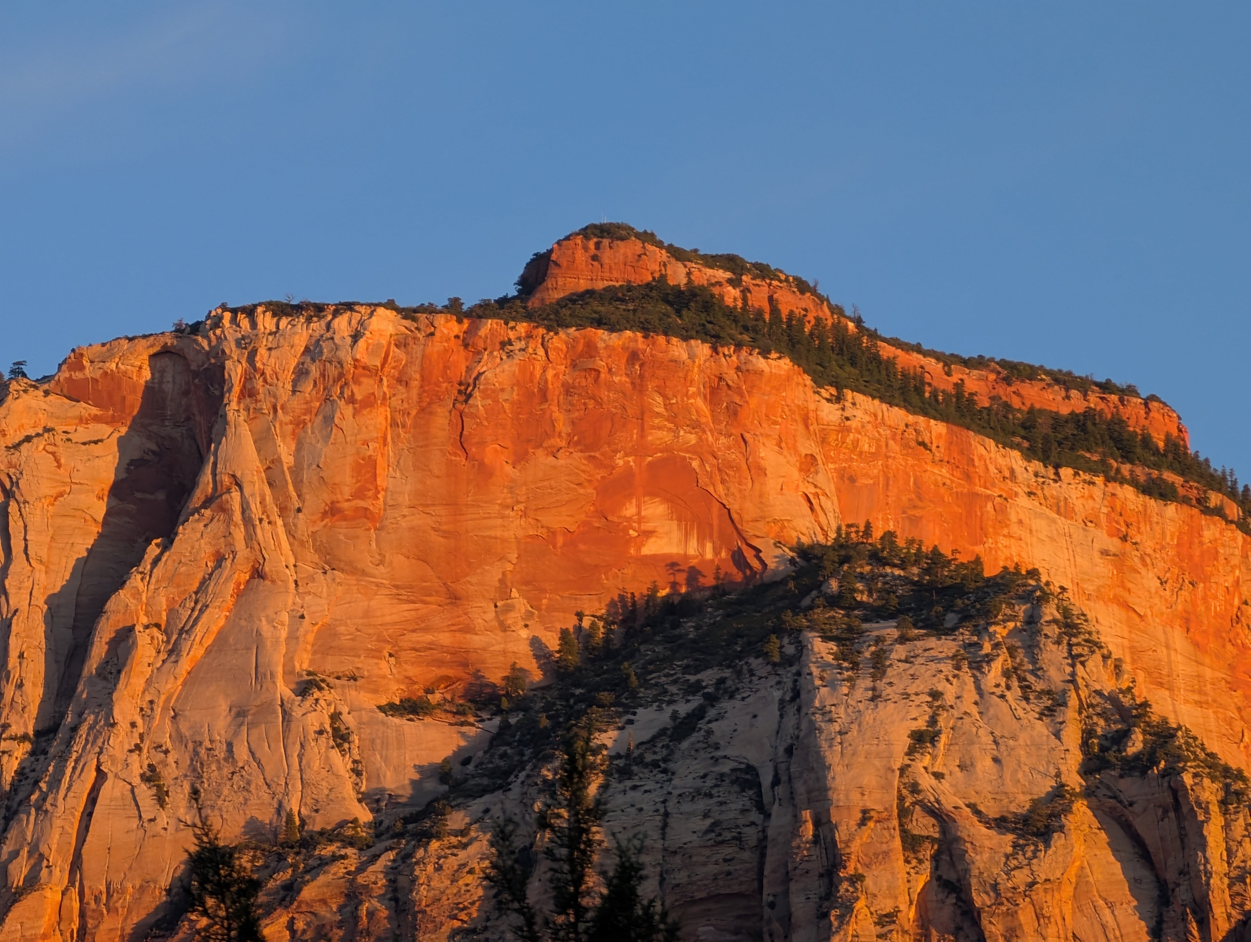
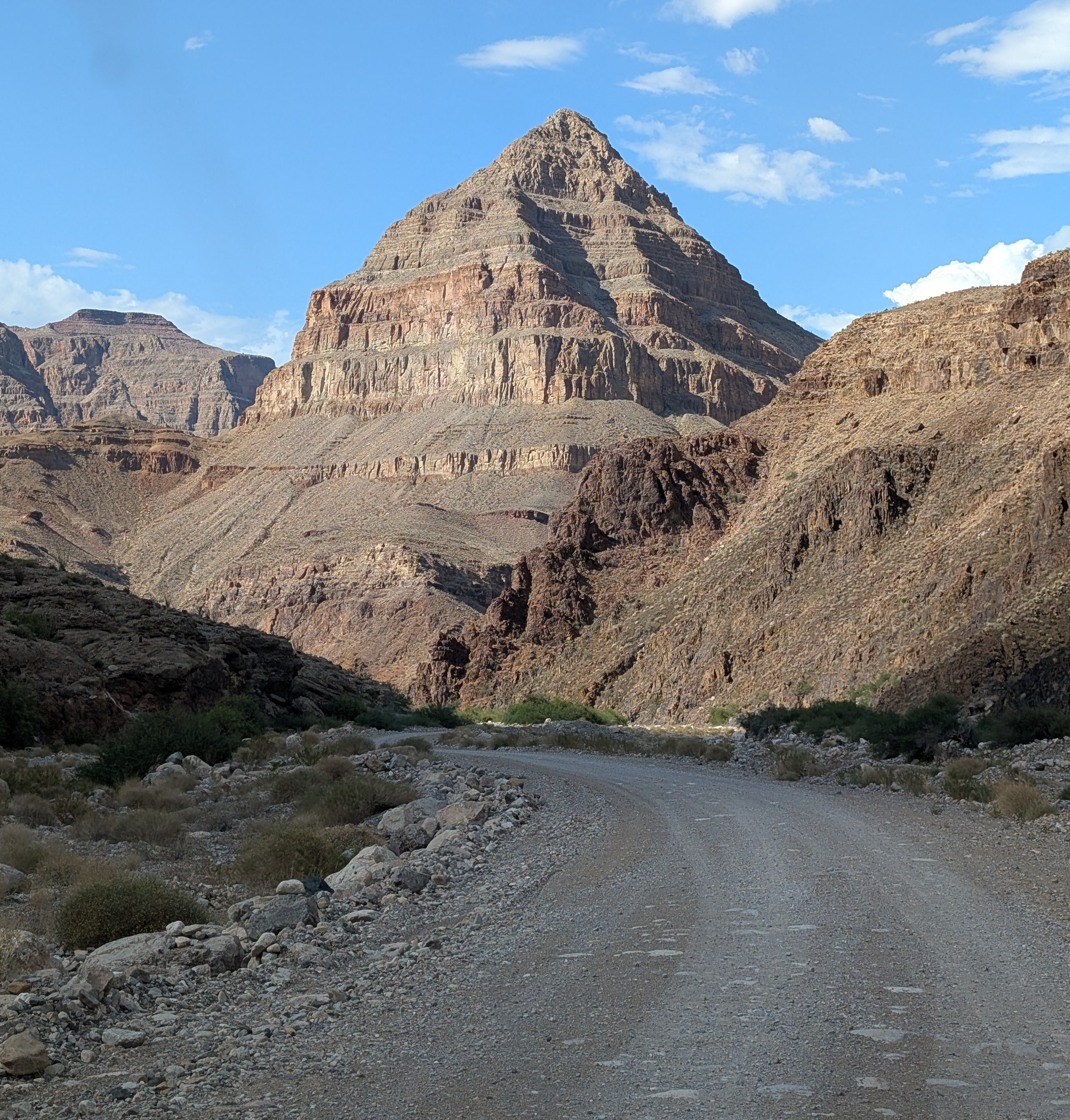
The "diamond" that gives the road its name: Diamond Peak

Without even considering the philosophical objections to building roads through the wilderness world of the Grand Canyon (objections I completely agree with), there are staggering engineering barriers. There are a series of formations, including the Redwall Limestone and the Coconino Sandstone that form sheer cliffs. The locations of trails in the Grand Canyon are controlled almost entirely by the few locations where they can surmount the cliffs of these two layers.

At Diamond Creek, the Hurricane Fault has offset the formations in just such a way that the cliffs can be avoided entirely. For the entire twenty mile length of the road, there is nary a cliff to worry about, as the road follows the bottoms of desert arroyos and washes. The biggest worry is flash floods and mudflows, which can easily shut down the road in July and August during the monsoons (and badly inconvenience river rafters who plan to take out at Diamond Creek). Unfortunately, our storm had all the hallmarks of an intense monsoon storm, and for all we knew, the road would be closed, and the whole endeavor moot. We were running late anyway, and I couldn't know the status of the road until we reached the Peach Springs office of the Game and Fish Service of the Hualapai Nation. We got there, and the sign on the door told me the worst...

All my plans dashed. But what can you do but barge your way into the office and see if the road was really closed? And it turned out that their closure was cautionary, the sign left from earlier in the day when no one had checked the road conditions. The road was okay, and I was given the permit to take our group into the canyon (the form interestingly was a permit to trespass on Hualapai land). It was the only permit given that day, and we would have the Grand Canyon to ourselves! We started down the gravel road, the Colorado River twenty miles away.

One can certainly debate the idea that it's "cheating" to drive to the bottom of the canyon, and there is a certain validity that scenery that hasn't been "earned" by completing a stiff hike might end up being less appreciated. But many people can't handle the very strenuous hiking and many simply don't have the time. Driving down into the canyon is a unique opportunity to study the oldest rocks of the canyon, the ones that are the very hardest to access in any other situation.

Diamond Creek cuts through to the Granite Gorge Metamorphic Suite, which is the oldest group of rocks found in the American Southwest, dating to as early as 1.8 billion years ago. At roadside there are marvelous exposures of schist, gneiss, and pegmatite granite with bright shiny crystals of muscovite mica and quartz.
Outcrops of schist intruded by pink pegmatite granite
A bit farther up the canyon one can see the layers of the Tonto Group, a series of three formations called the Tapeats Sandstone, the Bright Angel Shale, and the Muav Limestone. The three layers formed as the Pacific Ocean transgressed and covered much of the western North American continent in Cambrian time, just over 500 million years ago. The Tapeats Sandstone sits atop the rocks of the Granite Gorge Metamorphic Suite.
The Great Unconformity: the vertically oriented rocks in the lower half of the photo are the ancient metamorphic schist and gneiss. Above the metamorphic rocks are horizontal layers of the Tonto Group.
That last sentence needs a bit more explanation. The boundary between the Tapeats and the Granite Gorge rocks is a profound unconformity representing a gap of more than a billion years. This unconformity is actually called the "Great Unconformity", and is an erosional surface that was witness to not one, but two major mountain-building events. The metamorphic rocks were once the core of a vast mountain range that formed 1.7 billion years ago when the North American continent collided with a set of two exotic terranes, the Yavapai block and the Mazatzal block. Imagine an island the size of California or New Zealand grinding into the edge of a continent along a subduction zone and you will get the picture. This massive mountain range eroded to a flat low-relief surface over the next few hundred million years.
The Great Unconformity up close. Dark brown conglomerate of the Tonto Group rests unconformably atop the ancient metamorphic rocks.
Later on, about a billion years ago, the continent stretched and broke apart, forming a series of fault-block mountain ranges that reached heights similar to the mountains in and around Death Valley National Park today. The rocks of these mountains are exposed in the easternmost part of the Grand Canyon, but they too were eventually eroded down to a low-relief surface as well, although small  ridges a few hundred feet high persisted. Along the lower reaches of Diamond Creek Road, you can lay your hand on a boundary between two rock sequences with a gap of more than a billion years between them. The unconformity can be seen in the photo above where a conglomerate rests on contorted metamorphic rocks in the bit of shadowed ledge. The "Diamond" of Diamond Creek is the uniquely shaped peak on the left side of the photograph. It is actually a sliver of rock caught between two branches of the Hurricane fault system.

Another layer that is prominently exposed along Diamond Creek Road is the Devonian-aged Temple Butte Limestone. Most park visitors never see it because in the eastern section of Grand Canyon National Park the Temple Butte is a discontinuous thin layer that is pretty well invisible from the rim. In western Grand Canyon it is more than 700 feet thick. It formed as a tidal estuary and tidal flats along the edge of the continent about 385 million years ago.
Temple Butte cliffs in Diamond Creek
We reached the end of the road where Diamond Creek flows into the Colorado River, the watercourse responsible for carving the Grand Canyon. It was a moment for the students to cavort in the river for a few minutes, and to wonder at the work the river has done. This spot is where many of those who've rafted the river through the Grand Canyon take out, a usually raucous process, but no one was about on this particular day.
The most "mysterious" aspect of Diamond Creek and Peach Springs Canyon is that the tributary canyons to this creek follow illogical pathways, and are actually older than the Grand Canyon itself! It's an odd problem. Along the upper reaches of Peach Springs Canyon, there are a series of Paleocene to Miocene-aged rocks clinging to the canyon walls. They once filled the canyon, meaning the canyon was carved prior to sixty million years ago, and the rivers that carved it flowed northeast, opposite of the Colorado River today. Apparently the land subsided so that the canyons were filled with sediment, and then they were exhumed when the modern Grand Canyon was carved, most likely within the last four or five million years. There has been more than one Grand Canyon carved through the Colorado Plateau!
Peach Springs Canyon  (red) and the odd channels (blue) that were carved millions of years prior to the Grand Canyon itself (they were buried and exhumed when the modern canyon was carved).
Near the bottom of the road we happened upon a Bighorn Sheep. They were once more common and figured prominently in the Ancestral Pueblo petroglyphs found throughout the region. 
Diamond Creek is a fascinating excursion. It is entirely on Hualapai lands, and they charge a fee of around $17 per person for permission to drive the road. I never mind paying the fee, because the tribe doesn't have many sources of income or all that many jobs on the reservation. The town of Peach Springs where the road starts has a very nice motel and restaurant (and not much else), and if you are a train lover, you'll be able to listen to them all night long. The rails are amongst the busiest you'll ever see. The town is on one of the last remaining stretches of the original Route 66.

Our crew was ready to get to camp, so we drove an hour or so to my brother's cabin where we would spend the next three nights.
Wait a minute. Showers, kitchen, hot tub? You call this roughing it?

Sunday, June 22, 2025

Journeys in the Back of Beyond: Starting Off With a Bang


The Granite Mountains adjacent to the Mojave National Preserve

Actually it was a great many bangs. I shall explain...

Let's start with some basic statements. It's the Mojave Desert. It's almost summer. It doesn't rain in deserts, sort of by definition. I plan these excursions to avoid the monsoons of the Desert Southwest. And as the host at our first camp told us, "average June rainfall is 0.01 inches". We'll get back to this interesting meteorological situation shortly...

The first day of our trip was a traveling day, somewhere around 400 miles to get us out of the Central Valley and well into the Mojave Desert so we could reach the Grand Canyon the following day. My marvelous and courageous crew consisted of 17 students and several valued and faithful volunteers who have been making these trips possible for many years. We had a wonderfully diverse group, with some in their late teens, and others in their 60s, 70s, and one incredible traveler well into her 80s. 

All adventures devolve quickly into several basic questions: where is the nearest restroom? Where is the next mini-mart/gas station? How far do we have to camp? Sometimes, to my delight, there is a question about some geological feature visible in the distance: Is that a volcano out there? What's that weird white rock? Our expensive walkie-talkies ($9 each on Amazon) kept us in touch.

We made good time, and even had time to stop and have a look at the vast open pit mine at Boron (source of around half of the world's production of borax minerals). We pulled up to camp about 5 pm and started setting up.

The setting was dramatic. We were tucked in a small draw at the base of the Granite Mountains, which by incredible coincidence are composed almost entirely of granite. This granitic rock has the same origin as the famous granite batholiths of the Sierra Nevada, having been intruded into the continental crust as a result of subduction along the coast of western North America. The sinking slab of oceanic crust heated up and portions of it melted to form the granite magma that forced its way upwards through the crust where it eventually cooled. The subsequent history of the rock was different, however. Where the Sierra Nevada rose as a single massive block of crust sloping to the west, the Mojave twisted and deformed into a series of individual mountain ranges of more moderate elevation.
I guess I should have known what was coming. In my trained scientific experience, if there is a storm anywhere in sight, it will find a way to hit us. Despite the summer temperatures, skies were overcast, and there was a lot of energy in the clouds around us and rain was falling on the distant horizon. Camp was set up and we were preparing our dinner for the night when our phones simultaneously chirped, giving us a flash-flood warning. It was no spurious warning, either. Moments later, the sky opened up with the most intense hailstorm/rainstorm we've ever experienced in 40 years of field studies.


In mere moments the ground was covered with more than an inch of hail, some hailstones as large as quarters (the hood of my Subaru has dozens of small dings on it now). Every small gully and watercourse was filled with flowing water, including our entrance road. And the lightning was constant and terrifying (I didn't grow up in the Midwest, so these intense kinds of thunderstorms are new to me).

What had been dry sere desert moments previous was now coated in a covering of ice. There was enough hail left on the ground the next morning to use in my ice chest. It was a stunning storm.


The next morning as we left for Arizona, we realized we were lucky to be able to leave at all. Our access road had transformed into a river overnight, complete with braided stream channels, and some mud puddles remained that we carefully forced our way through.

Rivers had flowed over Kelbaker Road, but thankfully had not washed out the pavement.

Some nearby roads had been washed out and were closed to traffic, but we were able to reach the main highway and continue our journey east.

How did my students fare in such an incredible storm? 

I should backtrack a bit and explain what happened a few weeks earlier. In past trips we've always stayed at Black Canyon Campground in the Mojave National Preserve. It's a nice spot, and even has a shade structure that could have served as shelter from the downpour when it came. But I was poring over the maps and noticed the Sweeney Granite Mountains Desert Research Center. I remembered touring the place several decades ago, so I looked it up and discovered they had a cabin for use by students and researchers on the north slope of the Granite Mountains. On a whim I asked if they could accommodate our crew, and they were able to do so. 

During the worst of the storm, we were lounging in a nice dining/study area in a cabin!


The Granite Mountains Preserve is administered by the UC System, and covers around 9,000 acres of granite mountain slopes covered by pinon-juniper forests (and an uncomfortable amount of jumping cholla). They do research on all aspects of the desert/mountain ecosystems. There are several different kinds of accommodations for researchers, including the Norris Cabin where we stayed (below). It is a wonderful setting for field work in the desert!
And thus the first 24 hours of our two-week trip was done. The crew had been tested against the single worst storm our program had ever experienced and came out ready for more. Our next destination was the bottom of the Grand Canyon!

Saturday, June 21, 2025

Journeys in the Back of Beyond: Adventures on the Colorado Plateau


Devils Garden in Arches National Park
What is an adventure anymore? 

I ask my students to describe the meaning in one of my offbeat assignments in my geology courses and I get all kinds of answers. Many will describe a experience from our local educational camp in the Sierra Foothills, or an excursion they took to a local river or lake. Many of them have almost never left the city limits, and camping in the Sierra to them is terra incognita, far beyond their experience or expectation. 

I've always known I've had a blessed life in many ways, and what has made it especially rich is the privilege of leading my students on true adventures way out there in America's Back of Beyond, the Colorado Plateau and the Basin and Range country. I've just returned home from one of those journeys.

In Zion National Park

"Back of Beyond" is informally defined by Merriam-Webster as "a place that is very far from other places and people: a remote place". There are literary connections in the writings of Edward Abbey and C.J. Box, and a 1954 documentary from Australia. It is also the name of one of the finest bookstores in Utah. Outside of Alaska, some of the wildest and remote country in the United States is indeed the Colorado Plateau and the Great Basin, and to me it is some of the finest scenery in the world, and its geological story is fascinating. And...the land is endangered.

I'd like you to experience this country, if only through narrative and photography. I hope you will join me over these next few weeks as I describe our experience in a series of blog posts, and perhaps understand why we need to take action to protect the heritage of these fragile lands.

Mesa Arch in Canyonlands National Park

As usual, my ambitions often exceed my time allocation, so forgive me if delays occur in new postings!

Wednesday, May 28, 2025

The Coming Gigantic Crater in Arizona: The Supreme Court Fast-Tracks Destruction of Sacred Lands

Sometimes issues keep coming up. I hadn't heard of updates of the Oak Flat Controversy in a couple of years, but with the new administration, the issue has arisen again as the Supreme Court fast-tracks a controversial land swap to enable the opening of a massive copper mine (with a surprising dissent by Gorsuch). I have posted the following several times as the debates continued over the years. It was also one of the oddest geological issues I've ever come across. My brother took me to Oak Flat during a visit to the Phoenix area, and it wasn't until later that I found out the insidious actions taking place in Congress to destroy the area (for money, of course). How often do we hear of plans to produce a hole larger than Meteor Crater? This is at the expense of lands sacred to the San Carlos Apache Tribe, the Tonto Apache Tribe, the White Mountain Apache Tribe, the Yavapai-Apache Nation, the Yavapai-Prescott Indian Tribe, the Gila River Indian Community, the Salt River Pima-Maricopa Indian Community, the Hopi Tribe, and the Pueblo of Zuni. Please read on to find out what is being done to this sacred place.

When I see a representative insisting that a law must be followed ("Rep. Gosar is pressuring the Forest Service to enforce its rules that limit camping at Oak Flat to 14 consecutive days") when he helped subvert law to bring this situation about, I feel sick about our political system. In any case, like the title says, Arizona is going to get another Meteor Crater-sized hole, only bigger, and we know where and why it is going to happen...
This is NOT a killer asteroid entering the Earth's atmosphere. It is a sun dog over Oak Flat Campground near Superior, Arizona. Oak Flat is going to become a gigantic crater.

...because it won't be a meteor that causes it. It won't be an atomic bomb test. And it won't be because of aliens like those stupid ones in Indiana Jones and the Kingdom of the Crystal Skull. The giant crater will be entirely the work of human beings, and gravity. And it will destroy a place that is sacred to many, and was given protection by a Republican president 70 years ago.
Meteor Crater, Arizona is probably the most famous impact crater on the planet, and is about three-quarters of a mile across, and about 550 feet deep. The coming crater is expected to be about a mile across, and as much as 1,000 feet deep. How in the world is such a thing going to happen?
The town of Superior, Arizona is like many old mining towns of the west. It's depressed, it's poor, and few inhabitants really have a reason to stay. People made a good living out here at one time, mining and smelting copper from huge open pits nearby. But the mines closed decades ago.

But the copper wasn't all gone. With prices up, there is renewed interest, and Resolution Copper has outlined a huge ore body, one of the largest in the world. But there's a problem.
It's 7,000 feet beneath the surface.

The normal approach, open-pit mining, won't work. It's far too deep. Normal tunnel mining won't cut it either, because although the ore body is huge, it is low-grade, averaging around 1.5% copper, instead of the 5% or so that is required for profitable tunnel mining. So the company proposes to go after the ore using a process called panel caving (a type of block caving). They propose to start underneath the ore body, design a system of collection tunnels, and then fracture the rock above, allowing it to fall into the collection areas where the ore will be removed.
The process will allow the mining of vast amounts of ore, but what they will be doing will amount to removing an entire mountain from beneath the surface. Holes of such size cannot be maintained as open space underground, so the mine will collapse in a supposedly controlled manner. At the end of the mine's usable "life", the crater is expected to be about a mile wide and as much as 1,000 feet deep. Bigger than Meteor Crater.
There are huge social and political issues. Many people are fully supportive because money, but it's never entirely clear who will truly benefit, and who will actually get the jobs, and which political entities will get the tax revenue to support the regional infrastructure. And there is no guarantee that the mining company itself will maintain economic viability for the next sixty years. Such things are hard to predict, and the American West is littered with abandoned and depressed towns that were promised much and ultimately received little.
And then there is the matter of honor and history. Soldiers chose to die here, defending their homeland and families. When all was lost, more than four dozen of them chose to jump off the cliffs rather than be taken by the enemy. It was around 1870, and the deaths occurred only 1,500 feet from the edge of the proposed crater.

If the soldiers were U.S. military, I suspect there would be a cacophony of voices raised in righteous anger about the desecration of hallowed ground, and historical heritage and all that. But no, the warriors were Apache. The copper mining company insists that they respect the Native American heritage, and they make all kinds of public relations noise, but a great many local tribes and nations are deeply opposed to the operation.
I'm okay with weighing the pros and cons of a project like this, assuming that all parties are heard, and their concerns dealt with. But there has to be a willingness to say no, that some places should not be destroyed for the sake of profits over all other factors. I'm disturbed when those with the money are the only ones heard in the discussion and that there is an assumption that it will go forward no matter what. But ultimately politics requires a fair and open vote in Congress. And that's where the problem lies. The project will require a land swap that gives up federal land for "ecologically sensitive" lands elsewhere. And Congress has turned it down a number of times.
So in a bit of bipartisan corruption, the land swap was placed in a piece of legislation, the National Defense Authorization Act (NDAA) that had to be passed in 2014. It was a betrayal of trust on the part of people like Senators John McCain and Jeff Flake (speaking of corruption, Rep.Rick Renzi is in prison over crimes related to the land swap; and Senator Flake was once a lobbyist for Rio Tinto, one of the mine's corporate partners). This is the kind of political shenanigans that tells me that these plans need to be tabled for awhile. This isn't the way things should be done in our society.
How badly do we need this copper, really? And at what true cost? The entire situation has reeked of corruption and graft from day one. It's really strange that the Supreme Court Justice who has supported and enabled so much graft through the years was the one who dissented in this latest injustice. I keep hoping that the politicians will finally do the right thing, but my hope is fading as this situation continues to deteriorate. The current administration is only listening to the highest bidders from corporate America, and is unlikely to take any action. What faith I have is in those who are on the front lines protesting this invasion and rape of sacred land.

Sunday, May 18, 2025

The Eruption of Mt. St. Helens at 45 years: Why it Still Matters and Why Science Matters


It is the 45th anniversary of the eruption of the St. Helens volcano and as I think of those days, I realize that even though a majority of the population wasn't even alive at the time, the volcano still matters. Not because of the potential for future eruptions (although that remains a distinct possibility), but because of the way we process and deal with the natural hazards that we all face, no matter where we live.


When the volcano began rumbling and sending ash into the atmosphere, we had only a few avenues to get information, mainly television news, radio, and newspapers. I think now how limiting these sources were compared to the nearly instantaneous delivery of news over the internet in the present day. We can look up earthquakes just moments after they happen, and webcams allow us to monitor volcanoes around the world in real time. There is both good and bad in this profound change. There were terrible sources of news in those olden days, like the Weekly World News or the National Enquirer, but they pale in comparison to the sewage found on the internet today. Back then, national news outlets and newspapers in most instances practiced careful journalism, but it often seems today that the only reward for excellence and honesty in reporting is decreased ratings and falling revenues. To get attention in a crowded internet environment media outlets have to dress their stories as shiny objects and provide them with the worst possible clickbait titles. In the olden days we often had to wait impatiently for information about natural disasters, but the information that came through the media was more often vetted and checked for accuracy. The journalistic filters today are practically gone in many media sources, and it can be difficult to distinguish between the trash and the truth.


There are so many conspiracy theories floating around today about natural disasters and potential disasters. The eruptions of Steamboat Geyser in Yellowstone National Park a few years ago after years of quiescence caused a blizzard of posts on the internet pondering whether Yellowstone has been disturbed and may blow as a "supervolcano" eruption soon (and we'll all die). The same has happened after a number of recent small earthquakes. But a reading of the reality-based data says that Yellowstone caldera has not had a lava flow or eruption of any kind in 70,000 years, and no knowledgeable geologist sees any evidence of precursors to any new eruptions. A few years back, an earthquake and an internet video of a group of bison running "away" from Yellowstone caused the same kind of internet speculation (it turns out the bison were running towards the caldera).


Of course it is true that the Yellowstone caldera was born in one of the most colossal eruptions ever recorded. Learning the story of the eruption of the Huckleberry Tuff is fascinating. It brings an entirely new appreciation of the incredible scenery to be observed in a place that contains 70% of all the world's geysers. It should be enough. But there are so many individuals out there who would like to make a buck by scaring people needlessly. And there are too many gullible and ignorant people out there who can't pick rational accounts out of the confusing mix of conspiracy theories that exist on the internet.


And then there is the Big Island of Hawai'i. There were some serious and tragic things going in 2018 when the longest eruption in recorded history reached a climax. The activity endangered lives and destroyed homes as Kilauea underwent major changes from the "norm" of the eruptions that had been ongoing for the last 35 years. The U.S. Geological Survey and Hawaiian civil defense authorities did a pretty good job of providing up-to-date information about the latest activity, but that didn't stop all kinds of stories from popping up on the internet about the "Ring of Fire" which has nothing at all to do with Hawai'i. It was just too easy to pick up stories of eruptions in Alaska and Indonesia and think there was a pattern of increasing volcanism or earthquake activity (OMG, a magnitude 6 quake in the Kermadec Islands and an eruption at Mt. Cleveland in Alaska! It's a pattern and therefore Seattle will fall into the sea very soon!). The problem is one of perspective: if you had signed up for earthquake notifications and volcano advisories from the USGS or other geologic research institutions, you would have realized that these things happen all the time, and that a cluster of events is not unusual.


It's one thing to make up stories about normal volcanic activity to scare people. One can argue that they are ultimately harmless because the eruptions aren't actually taking place or hurting anyone. But there are real-world consequences of ignoring journalistic standards. Many of those who make their money with false headlines about such things also traffic in climate change denial. When science becomes a matter of believing whatever one wishes, the very real problem of global warming becomes just another "scare" story, and the alarm bells being sounded by climate scientists become just more noise in an internet full of noise. But the real-world consequences are happening now, and action is needed to counteract the changes or at least slow them down. But it has become too easy to ignore the problem because it is so incremental and slow-acting. It just can't compete with the shiny baubles and clickbait on the web.
People in Hawai'i mostly trusted the geologists who studied the volcanoes all their lives and thus made the correct decisions about evacuating homes and businesses. In the same way they trusted the seismologists when a tsunami threatened the islands in 2011 after the massive earthquake in Japan. No lives were lost when the tsunami hit because people had evacuated the low-lying areas. The wave surge was 8 feet deep in places and caused millions of dollars of damage. Many people could have been killed, but they accepted the authority of the scientists who predicted the timing and magnitude of the seismically induced waves.

There has been one characteristic about the natural disasters that I've described above. They were local events that profoundly changed lives, but in large yet limited regions. When earthquakes and volcanic eruptions strike, survivors can turn to other regional state and national governments for support, since those entities were not so badly affected. Now we face a different set of natural disasters: those that affect the entire planet. Climate change affects all of us. The rise of sea level is is global. Searing heat waves and intensified storms are affecting the entire planet. Extensive droughts and crop failures are rippling through the world economy. And it's getting worse even as the federal government denies climate change at the behest of the fossil fuel industry and eliminates the scientific expertise needed to deal with it.

And then there are the pandemics. The COVID-19 virus spread to literally every corner and every country of the planet in a matter of weeks. Scientific experts had long predicted the emergence of dangerous new strains of viruses, and previous administrations used the best scientific minds to prepare for their inevitable arrival. But those administrations were replaced by one that denigrated scientific expertise and fired the experts who could have crafted an appropriate national response to the COVID-19 virus. We saw the result: more than one million deaths in the U.S., lack of critical medical supplies and stockpiles, and a poorly coordinated federal response. Even worse was the propaganda campaign that convinced people that the disease was not as bad as it clearly was. Other countries listened to their scientists and saved countless lives. We are instead loosened critical restrictions even as the infection continued to spread. And now those who made the pandemic far worse are back in power.

That's why the Mt. St. Helens eruption of 1980 matters today. Scientific expertise matters. Pandemics will be a continuing problem in our interconnected world. Climate change is an even more profound danger to society than any virus, earthquake or volcanic eruption. We need people to give climate scientists the same kind of respect they give geologists when volcanoes are rumbling and smoking. They are the ones to listen to, not the hucksters on the internet who are out to make a buck, or trying to protect those industries that make their profits off of producing greenhouse gases. We seem to talk little these days about integrity and striving for excellence, but scientific researchers are among those who still have those traits. They are the ones to listen to, not the click-bait seekers and profiteers.


There was a sign that popped up at some of the March For Science protests that happened in the years before the Covid epidemic: "At the start of every disaster movie there's a scientist being ignored". Unfortunately, it is too true in real life as well.

This has been a highly abridged and updated version of a previous St. Helen eruption anniversary reflection.

Saturday, April 12, 2025

Do You Think You Know the Highest Waterfall in Yosemite Valley? You Could Be Wrong!


Quick quiz: What is the name of this waterfall?
What is the highest waterfall in Yosemite Valley? Depending on the parameters one can use to determine "height", your assumption may be wrong! Most "authorities" recognize Yosemite Falls (2,425 feet/739 meters) as the highest in Yosemite Valley and North America, and somewhere around the fifth or seventh highest in the world. But it depends on how you decide to measure waterfalls. By a different metric, Yosemite Falls isn't even the highest waterfall in Yosemite Valley. It's the word "falls", in the plural, that makes the difference.

I was in Yosemite Valley yesterday, and the falls were flowing strong. There is no doubt that Yosemite Falls is one of the most stunning sights on the planet. A chance movement of a glacier 13,000 years ago forced a middling stream from its old channel to the left of the current waterfall, forcing Yosemite Creek to drop right off the edge of the sheer cliff. You can see the old channel almost hidden in the shadows in the photo above.
The fall makes a sheer plunge of 1,430 feet (440 meters) at the Upper Fall and then cascades through a series of steep ledges called the Middle Cascades for 675 feet (206 meters). There is a final drop of 320 feet (98 meters) at Lower Yosemite Fall. The Middle Cascades are generally hidden from view unless you hike the steep trail up to the top of the falls (below).
Part of the Middle Cascades (April 2003)
But if one decides to be a purist about such things, one can define a waterfall's height on the basis of the greatest freefall. By that metric, Yosemite Falls still is an imposing 1,425 feet (739 meters) high. But it also means it's not even the tallest waterfall in Yosemite Valley.

Many first-time visitors to the valley are drawn to Bridalveil Falls (620 feet/189 meters) because it is the first major waterfall visible as one enters the valley. But when standing at the base of Bridalveil, they may see another high waterfall across the valley west of the sheer cliff of El Capitan and wonder if it is Yosemite Falls. It's not. It's called Ribbon Fall, and it has a single drop of 1,612 feet (491 meters). That's nearly 200 feet higher than Upper Yosemite Falls (it's the one in the picture at the top of the post). It is less familiar than many of the other waterfalls because it is usually dry by June when the majority of people visit the park. But if you get the privilege of seeing by visiting in the spring, you are in for a treat.
Ribbon Fall (1,612 feet) to the left with the 2,900 foot cliff of El Capitan to the right

Ribbon Falls is one of many treasures that make a spring visit to Yosemite Valley a worthwhile endeavor. If you want to see another springtime waterfall over a thousand feet high, check out Sentinel Falls.