Showing posts with label vitrophyre. Show all posts

Friday, March 13, 2015

A Roadcut as a Microcosm of a Province - The Charlie Brown Outcrop


A lot of geologic knowledge is gleaned from roadcuts. In less arid regions, vegetation and soil cover is so thick that roadcuts provide essentially the only information about the underlying geology. That isn't as much of a problem in the Basin and Range Province of Nevada, eastern California, and western Utah. It's a dry land, and the rocks stand out in bold relief. And with flat valley floors, roads don't need to be carved through solid rock all that often. But sometimes roads have to cross the mountain ranges, and there they are. A peek at the interior of a mountain range.
Some outcrops are more instructive than others, and once in a while, a road crew uncovers something spectacular. That's what happened when Highway 178, the Charles Brown Highway, was constructed over the Resting Springs Range from Shoshone, California to Pahrump, Nevada. It's about three or four miles east of Shoshone, and you can hardly miss it. There is a huge black "thing" climbing the slope that grabs your attention, and brings any geologist's foot down on the brakes. Caltrans has kindly provided a wide turnout, no doubt because of the congestion that occurs here during field studies season.
The view from the pullout takes in a broken land, as Professor Frank DeCourten has called it. The tan hills of the Resting Spring Range lie in foreground. Across the Amargosa "River" Valley is another ridge of twisted and broken rock, the Amargosa Range, then the Greenwaters, and on the skyline, the Black Mountains. Beyond lies the deep trough of Death Valley. This is a land with a violent history that has included dozens, if not hundreds of astoundingly huge volcanic eruptions, any one of which, if they happened today, could bring about the end of human civilization (through the disruption of agricultural production). The land was stretched until the crust snapped and huge fault systems developed, with deep fault valleys (grabens) and high mountain ranges (horsts). Whatever river systems existed were disrupted (one of them may have been the ancestral Colorado River). Today, even if there were water to flow, none would flow to the sea. The rivers would end in the adjacent valley, forming large lakes.

The Charlie Brown Outcrop, as it is informally known, encapsulates many elements of the story.
There are really three stories told in this exposure, that of distant ash eruptions, a violent eruption close by, and earthquakes with associated mountain-building.

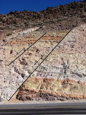
Distant ash explosions sent clouds of pulverized pumice shards that landed in lake beds and valley bottoms. The exposures took various hues due to oxidation of metals, mostly iron, in the ash beds. When major fault systems broke up the landscape, many smaller subsidiary faults shifted a few inches or feet. The ash beds and faults are nicely exposed on the right side of the outcrop. Pictures of this fault grace many geology textbooks.

The dark layer also tells of violent events. A nearby ash eruption produced very hot clouds of incandescent rock particles that landed in a thick layer, and remelted. Such rocks are called welded tuff or ignimbrite. The black layer is the most completely melted rock, and is called a vitrophyre. In essence it is obsidian, but not of a quality that one would want to make arrowheads with.
Photo by Mrs. Geotripper
It's all quite a puzzle for our field students who are seeing these kinds of features for the first time. We introduce the classification of faults, talk a bit about pyroclastic rocks, and then they sketch out the relationships that they can see. They give their best interpretation of what happened here, and the nice thing is, a lot of them find out that they can do a pretty fair job of discerning the story revealed by the rocks.

The idea of calling this the story of the Basin and Range in a roadcut was most assuredly not my idea. It comes from a short study of the rocks by Bennie Troxel and E. Heydari in 1982:

Troxel, B. W., and Heydari, E., 1982, Basin and Range geology in a road cut, in Cooper, J. D., Troxel, B. W., and Wright, L. A., eds., Geology of selected areas in the San Bernardino Mountains, western Mojave Desert and southern Great Basin, California: Geological Society of America, Guidebook, p. 91 – 96.

Tuesday, March 20, 2012

Strangers in a Strange Land: Tuff luck, it's all your fault, so don't be an ash about it.

So, what do you do first? You sketch it. Drawing forces you to recognize patterns that you might not otherwise see. Then you stick your nose on it. How many times have I dragged reluctant students on a field trip only to have them sit on the far side of the highway trying to text someone when there was no cell service? It wasn't the case with these students. This group was a bunch of go-getters.You do what you can to identify the rocks in the roadcut, at whatever skill levels you've reached. This trip to a Strange Land has brought together many strangers who have had no classes in geology and some who have had many.

We have to establish some possibilities. We sit down and talk it over. What in the world could that black stuff be? The whole outcrop is layered. Doesn't that make it a sedimentary exposure? Tilted, you think? An example of original horizontality? What if it were volcanic? That makes it basalt in the middle, but what is the red and brown stuff? Is it a flow or an intrusion? A book suggests that this is an intrusive sill. It that possible?

We start to organize our thoughts and questions. Look at the picture below...it was taken in an abandoned pit at the Black Mesa Coal Mine on the Navajo Reservation in Arizona. It is composed of light colored sedimentary layers. Although not visible in this image, there are coal seams between these layers. Could the mysterious black layer be a coal seam?
Or another serious possibility. At the other end of Death Valley I encountered an intrusive sill, a place where molten basalt forced its way between the layers of light-colored limestone. The basalt has weathered deeply to a brownish-red color, but a fresh exposure would be black. Could the Charlie Brown outcrop be a sill? How would the sill affect the color of the surrounding layers? Would it oxidize the iron in the sediments, turning the rocks reddish?
What about a buried lava flow? Maybe sediments were laid down, then a thin lava flow covered them. Then new layers of sediment buried the basalt flow. How would that look?

Armed with new information, the students take a second look. And they come back. "It's not coal, the rocks aren't right, and an intrusion shouldn't have holes and cavities in it. And the rocks on either side of the dark stuff don't look like normal sedimentary layers. We don't think any of your explanations work."

Their closer inspection of the rock reveals that the "layers" aren't really layers at all; all the contacts are gradational, one color slowly merging into another, getting progressively darker and darker until it turns black and shiny. It's obsidian! Or more properly, vitrophyre, a glass-rich volcanic rock. This outcrop is showing us something else entirely. The entire outcrop is a single volcanic deposit that formed in a single vigorous eruption.

A few million years ago a small rhyolite magma chamber broke through the crust and erupted violently, producing a small caldera and coating the surrounding landscape with seething hot ash. The first ash to hit the ground cooled quickly. But the interior of the ash deposit was still so hot that the portion about 10 feet above the base fused into the volcanic glass of the vitrophyre. The uppermost ash layers cooled quickly and did not darken like the rock in the interior. This exposure is an excellent example of a welded tuff.

I really love this outcrop...it encapsulates very well the concept of the scientific method. We see a phenomena that raises questions. We do a preliminary investigation that results in a number of possible explanations (hypotheses). We test each one, assuming that one of the hypotheses will be supported by the evidence, and that the other hypotheses will be shown to be wrong. Like many times in science, all the proposed explanations turn out to be incorrect, and we go back to square one, not yet at an answer, but far more knowledgeable about our mystery. In the end, if we are diligent, and sometimes lucky, we arrive at an answer that fits all the evidence.

At this outcrop we have the added benefit of being able to learn about the various kinds of faults, and use that knowledge to identify the faults found in the same roadcut. The left side of the fault (the headwall) is down relative to the right side (the footwall), making this a fine example of a normal fault, which is generated by extensional forces. The entire region, the basin and range province, has been stretched and broken, so the faults in this one outcrop are a microcosm of the faulting found throughout this strange landscape.
This is the kind of outcrop that shows that diagrams on a chalkboard can never be as powerful a learning tool as standing on the ground staring at and manipulating the rocks.

It was time for a bathroom and a cold drink...we headed down to the village of Shoshone and got ready to see the heart of Death Valley. In a coming post....

Wednesday, March 5, 2008

Picture of the Day - A Great Outcrop, Part 3


Apologies to Ron and Silver Fox for the delay revisiting last weekend's outcrop; all that death defying stuff distracted me. This is a well-known stop for many Death Valley field trippers at the south end of the Resting Springs Mountains just west of Shoshone. It is a marvelous site for teaching about faulting and aspects of volcanism. The prominent fault appears at first glance to be a classic reverse fault because of a tendency in one's mind to link the orange layers. The layer in the footwall (right) includes a dark lavender layer that is not present in the headwall, and thus the layers do not correlate. The smaller fault shows the correct offset.


The rocks in the outcrop are primarily air fall tuffs, although a megabreccia is exposed nearby. The rocks have clearly been tilted a bit.


Once my students finish looking at and sketching the faults, their attention is drawn to the dark layer to the left. It is a vitrophyre, a rhyolite ash flow that was so hot when it was erupted that it remelted to obsidian in the middle. A close inspection of the outcrop shows pumice pyroclasts that are progressively flattened towards the dark obsidian in the center of the flow. The upper part of the flow shows vesicularity as gases moved upwards during the cooling phase. Apparently the flow is in the original orientation; it was not tilted, but was instead plastered against a sloping hillside. The vugs contain interesting minerals, including zeolites and other silicates.


I wasn't so smart with this outcrop the first time I saw it. My instructor convinced us first that it was a reverse fault next to a coal seam, and then pointed out the inconsistency of the fault interpretation. Then it was hmmm? maybe not a coal seam, could it be a lava flow? Was it a dike? Oh dear, maybe we would have to figure out this whole thing ourselves.


Researchers much more talented then myself have published a tract about the outcrop that has been reprinted and is on sale at the Shoshone museum, which is also worth a stop if you are in the region. They have an excellent exhibit on the mammoths and other creatures that have been excavated in the region. Check it out!
  • Troxel, B.W., and Heydari, E., 1982, Basin and Range geology in a roadcut, in Cooper, John D., Troxel, Bennie W., and Wright, Lauren A., Editors, Geology of selected areas in the San Bernardino Mountains, Western Mojave Desert, and southern Great Basin, California: Volume and guidebook for field trip no. 9, 78th Anniversary Meeting of Cordilleran Section, Geological Society of America: Shoshone CA 92384, Death Valley Publishing Company, p. 91-96, 202 p.