Showing posts with label 6.9 magnitude earthquake. Show all posts

Tuesday, March 11, 2014

California's 6.9 Magnitude as Recorded at Modesto Junior College


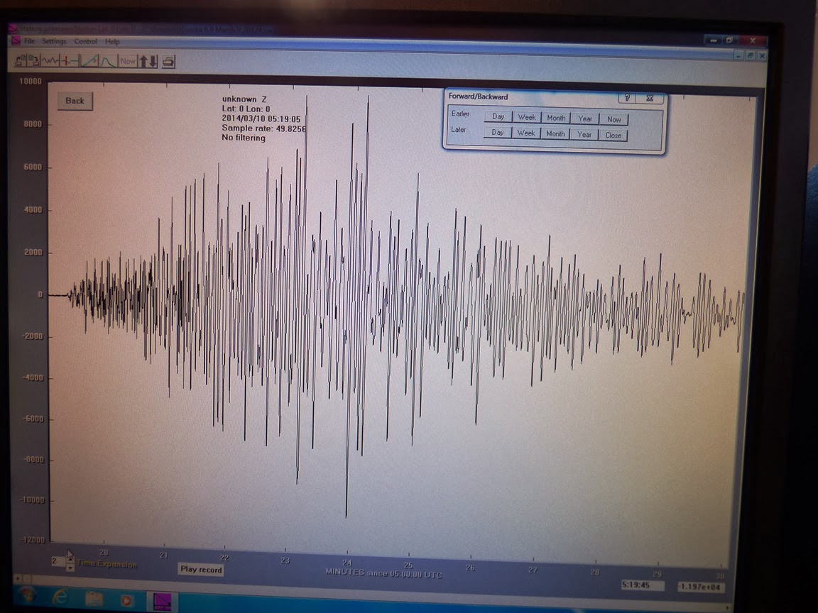
Here is California's 6.9 magnitude earthquake from last Sunday as recorded on our rather simple seismometer situated on the West Campus of Modesto Junior College. The unit is up on the third floor of the new Science Community Center, which is not ideal from a recording standpoint (the building is subject to all kinds of vibrations), but it's wonderful as an educational tool. We have one of the monitors up against a window where students can check for earthquake activity (and of course jump up and down to make their own earthquakes). The activity across the bottom of the record is the vibration of students walking by on Monday morning. This is the first major seismic event that we've recorded since installing the unit.

The horizontal lines on the monitor represent one hour increments, so the whole screen covers about 24 hours. The quake happened at 10:18 PM local time, and the shaking lasted for a good fifteen minutes. This doesn't mean that people were being shaken the whole time, because the actual humanly perceived shaking lasted only about 15 seconds. Instead, the ground continued to reverberate more slowly, so the movement was imperceptible. The waves would have continued all over the world and through the planet as well. They would have been detectable on a seismometer in India or Africa.

Here is the isolated and expanded version of the event. It covers about eleven minutes of the shaking:

Sunday, March 9, 2014

Magnitude 6.9 Earthquake Offshore of Northern California

A moderately large earthquake has been recorded offshore of Northern California, measuring 6.9 on the magnitude scale. It took place about fifty miles offshore of Ferndale, Eureka, and Arcata at 10:18 PM local time. It was apparently felt all over northern California, as far south as the Bay Area. There haven't been any reports of damage or injuries.

The quake took place in a complicated region where the San Andreas fault system intersects with the Cascadia subduction zone. It is close to the Mendocino Triple Junction where the Pacific, North American, and Gorda Plates are in contact with each other. Moderate quakes are not at all unusual in the region, with quakes measuring between 6.4 and 7.2 in 1923, 1932, 1954, 1980, 1992, and 2010. The Cascadia subduction zone generated a quake of around magnitude 9 in 1700, although it was farther north in Washington and Oregon.

A tsunami warning was not issued, presumably because the ocean floor was not lifted enough to cause one. Tsunamis are most commonly produced during compressional earthquakes in subduction zones, events that cause hundreds or thousands of square miles of seafloor to suddenly rise or subside. A quake the size of this one was either on a predominately strike-slip fault, or just didn't disrupt enough of the seafloor a sufficient distance.

As I write this, there have been half a dozen aftershocks recorded, mostly around magnitude 3, with one magnitude 4.6 event. There were also a few magnitude 3 events that could be considered foreshocks. Latest information from the U.S. Geological Survey can be found here: http://earthquake.usgs.gov/earthquakes/eventpage/nc72182046#summary, although I like the SCEC earthquake maps at http://www.data.scec.org/recenteqs/Maps/125-41.html as well.

I'll post updates if I get more information. I can hardly wait to see if the new seismograph at school was working this weekend!

UPDATE: A good synopsis of the geological circumstances of the quake has been posted at  http://seismo.berkeley.edu/blog/seismoblog.php/2014/03/10/the-strongest-california-earthquake-in