Showing posts with label plug dome. Show all posts

Saturday, October 26, 2013

The Volcano That Doesn't Exactly Look Like a Volcano: California's Lassen Peak

Lassen Peak is an odd one. Most people have a stereotypical view of what a volcano "should" look like, and to most people, Lassen doesn't fit the stereotype. Yes, it is an isolated peak from most angles, but where is the cone shape, and where is the crater on top?


We were on the last day of our late September field studies course through the Cascades of Northern California, and were having a look at the volcanic features of Lassen Volcanic National Park. In the previous post we took in a fascinating set of six plug domes, the Chaos Crags, and the debris avalanches that thundered down their flanks forming the Chaos Jumbles.

Like the Chaos Crags, Lassen Peak is a plug dome, a steep rubble-covered peak composed of dacite or rhyolite. It may be the largest plug dome in the world, rising about 2,000 feet above its base (most domes are half of that). It lacks the characteristic cone shape of stratovolcanoes because its lavas were so viscous upon emerging from the depths that they barely flowed at all, forming a steep pile of lava rather than relatively smooth slopes. As the lava cooled, it contracted and broke up, forming the talus slopes that coat most of the mountain.  A few rugged cliffs of solid dacite stick out here and there. The peak tops out at 10,457 feet, so it is often coated with snow.

Lassen Peak emerged during a series of eruptions about 28,000 years ago. The entire mountain probably developed in just a few years. Its shape was modified by latest episode of Pleistocene glaciations, but it was otherwise dormant for tens of thousands of years. Until 1914, that is...

In May of 1914 a steam explosion rocked the top of the mountain, producing a small crater on the summit. Over the next year at least 180 explosions blasted away at the summit, ultimately producing a 1,000 foot wide crater. The eruption made news across the country. Brave but foolhardy souls climbed to the summit to have a look, including several men who were standing at the summit on June 14th when B.F. Loomis made the famous images reproduced below (these are pictures I took of the displays in the Loomis Museum at Manzanita Lake).
One of the men, Lance Graham, was walloped by a rock in the shoulder and in the panicky moments that followed was left for dead near the top of the mountain. A rather lurid NY Times story described him as actually being dead, his arms cut off, a deep gash exposing his heart, and his body nearly torn in half; a later correction stated : "...he was reported to be dead, but the latest word is that he still is alive, although fatally injured". He apparently survived to live a long life (I recounted this story in one of my classes, and a surprised student piped up saying "Graham? He was my great grandfather!").

On May 19th of 1915, lava emerged from the volcano for the first time. The thick flow melted thick banks of snow and produced a major mudflow, or lahar, that traveled many miles down two valleys on the north flank of the mountain, destroying six ranch houses.

Source: National Park Service. Photograph by R.E. Stinson
The volcano was quiet for two days, and some may have thought the eruption was subsiding. It wasn't. On May 22nd, a huge explosion lifted ash 30,000 feet into the sky. A plume of hot ash swept down the north flank of the mountain, destroying the forest and all living things over an area of three square miles (these hot ash clouds are called pyroclastic flows or surges). This site is called the Devastated Area, and the demarcation between the old forest and the pyroclastic flow is still clear. The mountain has been quiet since 1917 (except for a puff or two of activity in 1921)

The eruption of Lassen Peak was for sixty years the only volcanic activity to take place in the lower 48 states, and as such was often the main topic of discussion in the volcanoes chapter of geology text books. It was a "nice" eruption in that it displayed many diverse phenomena (steam explosions, ash flows, lava flows, and mudflows), and didn't kill anybody (despite Lance Graham's near miss with mortality). Even though Mt. St. Helens stole all the attention, Lassen Volcanic National Park remains one of the best places I know of to learn about volcanism. And it is a beautiful place to visit.

More in the next post!

An excellent description of the 1914-17 eruption can be seen here: http://www.nps.gov/lavo/naturescience/upload/eruptions_of_lassen_peak.pdf

Thursday, October 24, 2013

Chaos! The Jumbles and Crags of Lassen Volcanic National Park

Lassen Volcanic National Park is one of the lesser-known and less visited of the national parks in California. Many have heard of Lassen Peak, but the park is located in the northern reaches of the state relatively far from most population centers. It's a fascinating place, and if one is interested in volcanism, there are examples of practically every type of volcanic feature within the borders of the park. How many places in the world have shields, lava plateaus, stratovolcanoes, plug domes, cinder cones, and calderas, as well as active geothermal fields (fumaroles, boiling mudpots, and hot springs; everything except geysers, so Yellowstone can rest easy). The park is also noted for the recency of many of these features, with numerous cones and flows that are less than a few thousand years old (Lassen itself erupted from 1914-1917).

On our recent trip, we approached the park from the north, and the first sight we beheld was beautiful Reflection Lake. In the morning light it was serene and quiet, and it was strange to consider the violence that led to the lake's formation (along with nearby Manzanita Lake). The forest hides the hummocky surface of the landscape that surrounds the lake, but a short distance up the road, the origin of the lake becomes clear.
The Chaos Jumbles is the remains of a large debris avalanche that thundered down the slopes of  nearby Chaos Crags. The lack of soil and vegetation suggests that the avalanche deposits are not old (there are at least three of them), and indeed none of the trees on the slide date to more than three hundred years. The slide traveled on a cushion of compressed air, traveling for more than two miles and climbing some four hundred feet up the slope on the far side of the valley. It blocked several streams, ultimately forming the beautiful lakes.
The rocks that make up the slide are quite interesting as well. They are volcanic, but not the black basaltic rock that people associate with lava flows and volcanoes. It is a pinkish brown volcanic rock called dacite. Dacite is intermediate in composition between rhyolite and andesite, containing the minerals quartz, plagioclase, hornblende and biotite. The volcanic rock also contains enclaves of a darker volcanic rock, an andesitic basalt that shows that two different magma chambers were comingling and mixing. The mixing probably was a factor in the eruptions of the dacite.
An aerial shot of the Lassen vicinity shows the Chaos Crags in sharp outline. They are the barren snow-free peaks to the left of the main cone of Lassen Peak (the Crags lie north of Lassen; the picture is oriented towards the southeast). Given the dense thick forest that surrounds the volcanoes and the barren nature of the Crags, they have to be exceedingly young, and dating indeed places their age at about 1,100 years before the present. Six individual domes were erupted during a period of about 60 years.

The Chaos Crags are excellent examples of plug domes, short steep cones produced by highly viscous lava flows. The lava emerged like toothpaste from the ground, and as it cooled, the surface of the lava contracted, breaking up and forming huge debris piles on the margins of the cone.

The six domes have been creatively named A, B, C, D, E, and F. Domes E and F can be seen in the picture below, while Dome D dominates the bottom picture.

In any other setting, the Chaos Crags would be the central focus of a volcanic park, but the much taller peak of Lassen stands less than two miles away, so they tend to be somewhat ignored. That's too bad because there are few better examples of plug domes to be found anywhere, and the youthfulness of the Jumbles suggests continuing geologic activity. A stop among the chaos of the Crags and Jumbles is a great introduction to the geology of Lassen Volcanic National Park!

Friday, October 18, 2013

Scenes from a Shield: Isn't This Supposed to be Basalt?

Medicine Lake Highland (from an earlier trip when it wasn't covered with storm clouds).
Medicine Lake Highland at first glance sure looks like a classic version of a shield volcano. The gently sloping flanks indicate the presence of non-viscous basaltic lava, and the lava tubes we explored were certainly composed of basalt. As we moved further up the flanks of the mountain we encountered tree molds (those were the mystery holes in the previous post, as Lockwood correctly surmised) that also occur in basalt flows. By the time we reached the summit of the volcano and the caldera at Medicine Lake we were starting to see different kinds of lava. Some gray colored andesite could be seen on the north flank of the caldera.

The most striking kind of lava was what we saw at Glass Mountain, the most recent lava flow on the mountain, dating to only 900 years ago.

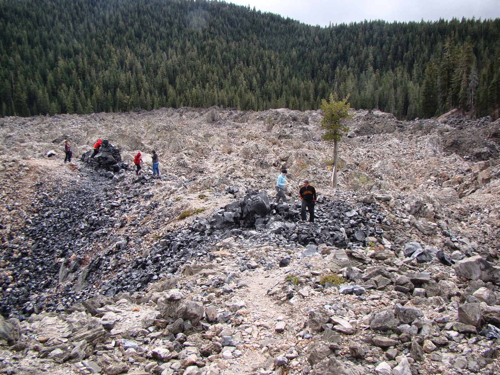
Everything about Glass Mountain is a complete contrast to basalt. The steep debris-covered flanks of Glass Mountain show that the lava flow was highly viscous and barely able to flow at all. The light color of the lava contrasts sharply with the black of basalt. The mountain is composed mostly of obsidian and pumice, glassy rocks that usually have a chemical composition equivalent to rhyolite.  
Glass Mountain is a typical example of a plug dome. Such volcanoes are small, usually no more than a thousand feet tall, with steep rubble-covered sides. The lava flows from the cone are rarely very long, and are thick and very rugged.

One might wonder what rhyolite is doing on the summit of a gigantic basaltic shield volcano. Such things are not usually seen on Hawaiian shields, for instance. A bit of information about the melting points of minerals and the composition of the crust can help us to understand what happened on Medicine Lake Highland.

The minerals found in basalt have high melting points. For basalt to be in a liquid state requires temperatures of 2,000 °F or more. Rhyolite on the other hand contains minerals that melt at lower temperatures, maybe in the range of 1,300 °F.

Oceanic crust is essentially composed of basaltic rock. Continental crust is more granitic in composition, and granite is what you get if rhyolite cools very slowly (granite and rhyolite are made of the same minerals, in other words).

Medicine Lake Highland is situated on the diffuse boundary between the Cascades Province and the Basin and Range, a region that is being stretched or extended in an east-west direction. The extension is causing faults to form in the crust, and the faults are allowing basalt to approach the surface from its source in the Earth's mantle. The basalt magma, as noted, is very hot.

As the basalt rises through the thick granitic crust, the intense heat causes melting of the granite, and magma chambers form that are composed of rhyolite. The basalt and rhyolite magmas don't play well together, and don't readily mix. As a result, some eruptions are basaltic, and others rhyolitic. This phenomenon is called bimodal volcanism.

Many people don't realize that pumice and obsidian are the same thing: volcanic glass. They are the same in the way that root beer and the foam on the root beer are the same. It's all root beer, but the foam is full of air bubbles. A bit of exploration on the flow at Glass Mountain revealed intriguing flow structures with interlayered pumice and obsidian.

We finished our exploration of Glass Mountain and headed down the heavily wooded south flank of Medicine Lake Highland. Brief views through the trees offered wonderful vistas of the surrounding terrain of the Modoc Plateau.

Medicine Lake is not a "typical" Cascades volcano like Rainier or Shasta but there is at least one other massive shield complex to the north in Oregon at Newberry Crater. Both are famous for their obsidian domes.

We had one more stop for the day, on the Giant Crater Flow, a basalt flow that is comparable to the Mammoth Crater flow that produced the lava tubes in Lava Beds National Monument. One tube system from Giant Crater extends for fourteen miles down the south flank of the Highland. At Jot Dean Cave, there was an extraordinary exposure of ice.

Jot Dean Cave doesn't seem to extend all that far, or at least none of us wanted to find out. The reason is the rather steep slope at the edge of darkness that is completely covered with very slick ice, even in late September. The strangest part is the huge mass of ice on the left side of the entrance that refracts light from the outside and seem to glow internally. It's actually kind of eerie; I imagined that the ice had formed around some poor spelunker and his light was still glowing...

We got back into the vehicles and headed towards our camp for the evening at one of California's most beautiful state parks.

Tuesday, September 23, 2008

Back from the Eastern Sierra Nevada


We are back from our journey to the east side of the Sierra Nevada, mostly in one piece, mostly not sore, and quite not thrilled to be back in a stuffy classroom! We spent four days touring the length of the Owens Valley, Mono Lake basin, the White Mountains, and the barren hills around the ghost town of Bodie.

The Sierra Nevada is a discrete block of continental crust that is considered to be sort of a micro-plate that is moving northwestward, stretching and breaking the crust in its wake, causing the formation of the deep fault valleys of the Basin and Range province. Owens Valley is one of the deepest of these, with a floor at 4,000 feet, and mountains on either side reaching 14,000 feet (a valley nearly twice as deep as the Grand Canyon, but not carved in any way by rivers). The Sierras include numerous granitic intrusions interspersed with roof pendants of older metamorphic rocks. The lesser-known White Mountains on the east side of Owens Valley are composed of some granite, but mostly of late Proterozoic and early Paleozoic sedimentary and metasedimentary rocks (the Cambrian sediments alone are around 3 miles thick).

Growing up, I thought the eastern face of the Sierra Nevada would be a great stand-in for the Mountains of Mordor in the Lord of the Rings by J.R.R. Tolkien. The rocks make a nearly impassable barrier for something like 100 miles with only an occasional pass at less than 10,000 feet. To say the mountains are scenic is a gross understatement...the first of today's photos is the range crest in the vicinity of Mt. Williamson near the village of Independence.

Farther north, the mountain front is only slightly less rugged, but other factors make for a fascinating geology field trip. In the center photo one can see the inland sea of Mono Lake in the foreground, some of the plug domes of the Mono Craters in the middle distance, and the high peaks just east of Mammoth Lakes on the skyline (the view is from the viewpoint near Conway Summit on Highway 395).

Mono Lake is an ice-age relic that has no outlet (a pluvial lake), so water leaves the region only by evaporating. There are no fish (it is three times saltier than sea water), but there are plenty of brine flies and their larva, and there are trillions of brine shrimp. This is a tasty mix for the millions of birds that use the lake as a stop-over on their seasonal migrations. The lake lost much of its volume when Los Angeles diverted many of the streams that fed the lake in 1942. Recent litigation has led to an agreement to bring the level of the lake to something approximating its original depth (not really, but at least enough to keep the shrimp and flies alive). Parts of the shoreline are decorated by the eerie looking tufa towers that form where fresh water springs flow into the brine.

The Mono Craters have very few actual craters. They are instead a curving line of rhyolite plug domes that began erupting around 35,000 years ago, and it is a safe bet to say they are not done yet; the last episodes of volcanic activity were only 600 years ago, at Panum Crater and Inyo Craters.

The last photo shows one of the oldest living things in existence: a bristlecone pine. Some of these trees have survived for 4,500 years in the harsh environment at 10,000 feet on the flanks of the White Mountains. The tree in the picture is not dead; a thin line of bark and a few needle-covered branches show that it still lives. It is one of the old ones, though. The fierce winter winds have abraded and polished the resin-rich wood where the bark is gone. Even the dead trees persist; a dendrochronology of the living and dead trees reaches back at least 7,000-8,000 years, giving us an accurate record of droughts and climate change over the time period.

Four days is not nearly enough time to see all the geologic wonders in this region...