Showing posts with label Rhyolite. Show all posts

Sunday, December 6, 2015

I've Been Under, Over, and On a Volcano. Now Let's Go Into a Volcano


Being on a volcano isn't too bad,at least if it isn't erupting. In Hawaii, I've even enjoyed being on an erupting volcano. "On" isn't too hard as a rule. You just drive or walk on it. Being over a volcano takes a little aerial technology, but flying to Seattle on a clear day does the trick. I've occasionally posted aerial shots of the Cascades volcanoes.
Getting under a volcano is a bit trickier. One needs to find a place where the magma chambers feeding a volcano have cooled and solidified, and then wait a few tens of millions of years while the crust rises and is stripped away by erosion. The exposed rocks would include granite, granodiorite, tonalite, and diorite. There are some very nice places to see such rocks, especially in my backyard, at Yosemite, Sequoia, and Kings Canyon National Parks in the Sierra Nevada. Needless to say, I've written just a little bit about these places...
Getting into a volcano is pretty much like getting underneath one. It takes less time, since only thousands of feet of erosion are needed, instead of miles. The trick is finding an accessible deeply eroded volcano. One of the most scenic of all eroded volcanoes has to be the half volcano of Pinnacles National Park in California's Coast Ranges. I don't mean "half" in the sense of half eroded away. Half of the volcano is missing for other reasons (read on...).

We took our last official field trip of the semester a few weeks back, and our destination was Pinnacles, being our nation's national park, and one of the most scenic and geologically interesting parts of the Coast Ranges (although there are many things that are geologically interesting about the Coast Ranges). Of course, as is my wont, I lectured and talked about the geology, but no lecture can ever compete with field experience. I sent the students up the trails to see the geology up close.

I headed up the Condor Gulch Trail. It connects after 1.7 miles with the High Peaks Trail, which is one of the finest short hikes in North America. My heart was there, but not the time. I made for the Condor Gulch Overlook, and continued another half mile to gain some wonderful views of the surrounding territory.
The volcano at Pinnacles National Park was a composite cone with at least five vents or domes composed of rhyolite lava and breccias. I imagine the closest analog to the volcano in California today wold be Mammoth Mountain in the eastern Sierra Nevada, although Pinnacles was situated much closer to the ocean, and may have been partly under water. Most of the rocks exposed along the trail began as mudflows on the flanks of the volcano, the summit of which was located a couple of miles south of the trail I was following.
From the Condor Gulch Overlook, one can look into a series of potholes where the intermittent stream flows over the volcanic bedrock. Boulders in the swirling currents have eroded the holes, which may hold water for weeks or months after major storms. The water is can be critical for wildlife in the area.

The Pinnacles volcano erupted near the newly forming San Andreas fault system, and the volcano was actually split in half by the fault motions. One part of it remained in southern California where the exposures are called the Neenach Volcanics. They can be seen in the Lancaster area quite close to the Antelope Valley Poppy Preserve. The rocks on the other side of the fault were carried north some 195 miles (314 kilometers) over 23 million years. It wasn't wasn't fast...maybe 2 inches per year, but the manner in which it happened was pretty violent. Every century or so there would be an earthquake in the range of magnitude 7.5-8.0 that moved the fault 10-20 feet all at once. The process continues today, with the San Francisco earthquake of 1906, the Fort Tejon earthquake of 1857, and the Loma Prieta earthquake of 1989. Enough stress is built up on various segments of the faults to produce large and damaging earthquakes, events that California needs to be prepared for.

From the ridgetop, the landscape appears gentle and serene. The thick brush and Gray Pines hide evidence of a violent past: volcanic eruptions, earthquakes, mudflows, and landslides. Today, the park is a delightful place to explore, with 30 miles of trails. I certainly enjoyed the three miles I traveled the other day.
If you are having trouble visualizing what 195 miles looks like, check out the fault map below that shows the location of the San Andreas, the Pinnacles volcano, and the Neenach volcanics.

Friday, October 18, 2013

Scenes from a Shield: Isn't This Supposed to be Basalt?

Medicine Lake Highland (from an earlier trip when it wasn't covered with storm clouds).
Medicine Lake Highland at first glance sure looks like a classic version of a shield volcano. The gently sloping flanks indicate the presence of non-viscous basaltic lava, and the lava tubes we explored were certainly composed of basalt. As we moved further up the flanks of the mountain we encountered tree molds (those were the mystery holes in the previous post, as Lockwood correctly surmised) that also occur in basalt flows. By the time we reached the summit of the volcano and the caldera at Medicine Lake we were starting to see different kinds of lava. Some gray colored andesite could be seen on the north flank of the caldera.

The most striking kind of lava was what we saw at Glass Mountain, the most recent lava flow on the mountain, dating to only 900 years ago.

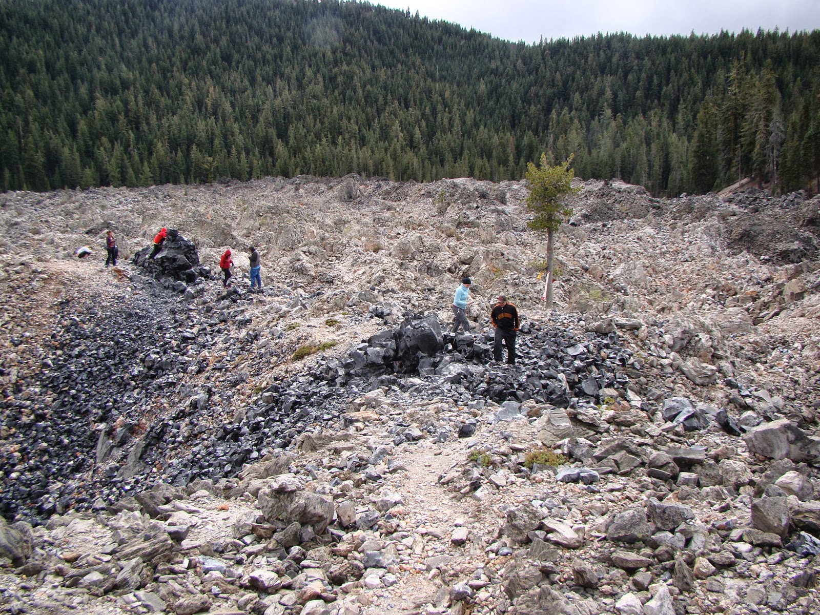
Everything about Glass Mountain is a complete contrast to basalt. The steep debris-covered flanks of Glass Mountain show that the lava flow was highly viscous and barely able to flow at all. The light color of the lava contrasts sharply with the black of basalt. The mountain is composed mostly of obsidian and pumice, glassy rocks that usually have a chemical composition equivalent to rhyolite.  
Glass Mountain is a typical example of a plug dome. Such volcanoes are small, usually no more than a thousand feet tall, with steep rubble-covered sides. The lava flows from the cone are rarely very long, and are thick and very rugged.

One might wonder what rhyolite is doing on the summit of a gigantic basaltic shield volcano. Such things are not usually seen on Hawaiian shields, for instance. A bit of information about the melting points of minerals and the composition of the crust can help us to understand what happened on Medicine Lake Highland.

The minerals found in basalt have high melting points. For basalt to be in a liquid state requires temperatures of 2,000 °F or more. Rhyolite on the other hand contains minerals that melt at lower temperatures, maybe in the range of 1,300 °F.

Oceanic crust is essentially composed of basaltic rock. Continental crust is more granitic in composition, and granite is what you get if rhyolite cools very slowly (granite and rhyolite are made of the same minerals, in other words).

Medicine Lake Highland is situated on the diffuse boundary between the Cascades Province and the Basin and Range, a region that is being stretched or extended in an east-west direction. The extension is causing faults to form in the crust, and the faults are allowing basalt to approach the surface from its source in the Earth's mantle. The basalt magma, as noted, is very hot.

As the basalt rises through the thick granitic crust, the intense heat causes melting of the granite, and magma chambers form that are composed of rhyolite. The basalt and rhyolite magmas don't play well together, and don't readily mix. As a result, some eruptions are basaltic, and others rhyolitic. This phenomenon is called bimodal volcanism.

Many people don't realize that pumice and obsidian are the same thing: volcanic glass. They are the same in the way that root beer and the foam on the root beer are the same. It's all root beer, but the foam is full of air bubbles. A bit of exploration on the flow at Glass Mountain revealed intriguing flow structures with interlayered pumice and obsidian.

We finished our exploration of Glass Mountain and headed down the heavily wooded south flank of Medicine Lake Highland. Brief views through the trees offered wonderful vistas of the surrounding terrain of the Modoc Plateau.

Medicine Lake is not a "typical" Cascades volcano like Rainier or Shasta but there is at least one other massive shield complex to the north in Oregon at Newberry Crater. Both are famous for their obsidian domes.

We had one more stop for the day, on the Giant Crater Flow, a basalt flow that is comparable to the Mammoth Crater flow that produced the lava tubes in Lava Beds National Monument. One tube system from Giant Crater extends for fourteen miles down the south flank of the Highland. At Jot Dean Cave, there was an extraordinary exposure of ice.

Jot Dean Cave doesn't seem to extend all that far, or at least none of us wanted to find out. The reason is the rather steep slope at the edge of darkness that is completely covered with very slick ice, even in late September. The strangest part is the huge mass of ice on the left side of the entrance that refracts light from the outside and seem to glow internally. It's actually kind of eerie; I imagined that the ice had formed around some poor spelunker and his light was still glowing...

We got back into the vehicles and headed towards our camp for the evening at one of California's most beautiful state parks.

Sunday, June 2, 2013

Picture of Peach Springs Tuff (with Big Bird Bonus)


The Internet connection at our hinterlands location is slow and undependable, so tonight is just a picture of the Peach Springs Tuff, an 18.5 million year old rhyolite tuff that covered a vast area between Peach Springs Arizona and the Mojave Desert near Barstow. It is nicely exposed along the old Route 66 in Kingman Arizona, which was one of our stops today. There also seems to be a large fledgling bird sitting on the rock and partly blocking the view, but I found it interesting. I am assuming it is a Red Tailed Hawk fledgling. Is there anyone who can confirm or correct?

Wednesday, December 28, 2011

Dispatches from the Road: Feeling Detached in Saguaro National Park

Had a few spare moments from family matters while in Tucson, Arizona today, so we headed out to Saguaro National Park and Tucson Mountain Park, which are both on the outskirts of the city. I'm not overly familiar with the area's geology, so it was a real learning experience. I really wish I had more time here!

The first thing that happened is that this mockingbird got in the way of my picture of the far mountain ridge. There was a beautiful bright red cardinal, too, but I couldn't convince it to block the scenery for me...
The Saguaro cacti kept getting in the way of the shots of the rocks, too, but I guess they provide some sense of proportion. The mountain ridges in the Rincon District of Saguaro National Park looked vaguely familiar to me, forming a roughly domal shape.
A convenient pull-out confirmed my suspicions...these rocks were reminding me of Death Valley...specifically the Black Mountains on the east side where several detachment faults are prominently exposed. Detachments are evidence of extreme extensional forces in the crust of the Earth. As the younger overlying rocks slip off the underlying ancient rocks, the rocks bow upwards forming the dome-like outlines. Deeply deformed rocks called mylonite are found along the fault contacts
The younger overlying rocks actually ended up on the other side of the Tucson valley. They make up the rocks exposed in Tucson Mountain Park, which we visited briefly while looking for a place to watch the sunset. Much of the rock is volcanic rhyolite, formed during intense caldera eruptions similar to those that produced Yellowstone and Long Valley (in California). The sharply jointed rocks form prominent peaks that do a nice job of catching the last rays of the sun.
 I am almost never disappointed by an Arizona sunset...
The Saguaros always provide a nice frame for pictures of the sky and horizon...almost a cliche that you've seen a thousand times in calendars, but there is nothing like being there. I couldn't stop snapping pictures, and if I didn't have a camera, I would have sketched. And if I didn't have a sketch pad, I would have scratched images on the rock, much as the original inhabitants of this country did thousands of years ago. It's that pretty.
From Gates Pass, the view was stupendous. We watched until darkness, and headed back down into Tucson for dinner. Gotta get some sleep, because tomorrow we are headed to the Grand Canyon! To research the summer field trip, of course....
For some information on the geology of Saguaro National Park and the adjacent Tucson Mountain Park, check out this pdf file.

Saturday, January 9, 2010

The Other California: Geologists Who Live on Glass Mountains Shouldn't...(fill in moral)

Oh, come on, who of you hasn't done the manly-man or womanly-woman thing when confronted with a mountain of pumice boulders? That's one of the cool things a person can do when visiting one of California's unknown corners, Medicine Lake Highland, the biggest volcano in the state.

In the previous post about the volcano, we were exploring the varieties of non-viscous basaltic lavas, the so-called a'a and pahoehoe flows. Basalt is a silica-poor volcanic rock that is usually derived from melting below the crust in the earth's mantle. In places like Hawaii, basalt is essentially all one will find. Medicine Lake Highland sits on silica-rich continental crust, and hot magmas rising from the mantle mix and melt the continental crust, forming a variety of more silica enriched lavas, such as andesite or rhyolite. These are the lavas that lead to the distinctive nature of the Medicine Lake Volcano. Several unique kinds of volcanic cones dot the summit region of the volcano, including Glass Mountain, shown in the pictures below (and above, for that matter). Glass Mountain is also the youngest volcano on the Highland, having erupted only 950 years ago. Note how few trees have gained a roothold on the new rock.

The silica molecules that make up much of rhyolite magmas tend to stick to each other, forming polymers, and making the lava very viscous (sticky). Atoms can't move readily and the cooling lava tends to form glass (disorganized atoms) instead of a crystalline rock. Natural volcanic glass, as many of you know, is called obsidian. This is the material used by early cultures to make spearpoints, arrowheads and other tools (it makes a sharper edge than metal and is used in surgical scalpels today). Glass can form from other lavas like basalt or andesite as a result of sudden quenching, as in water, but such glass tends to be only on the surface of the rock.

Is the foam on a mug full of root beer actually root beer or is it something else? Of course it is root beer, it just has a lot of airholes in it. Pumice has the same relationship to obsidian. It is also volcanic glass, only it has a lot of gas bubbles in it. As such the rock has very low density so that it can float for one, and out-of-shape middle-aged geologists can pretend to be really strong hefting it around for another. The two rocks are found in abundance at Glass Mountain.

The rhyolite lava is so viscous that it rarely flows at all, and instead builds steep rubble-covered cones called plug domes or silica domes. Glass Mountain is a prime example (on the right skyline in the photo above), but it includes some flows as well (below). In class, I describe the behaviour of the lava as being like toothpaste being squeezed straight up so that it just kind of flops over.

Glass Mountain is high on the east flank of Medicine Lake Highland, and nice views can be had of the Modoc Plateau in the far distance. Getting to the plug dome requires travel on some dirt roads with a few confusing junctions, but get a national forest map and follow the signs, and normal cars can get there with no problem (it is stop 4 on this sketch map). There is a rough access road that allows people to hike over the extremely rugged surface, but be forewarned: the glass is very sharp and unforgiving. Almost every field trip I take there results in a few bloody cuts. The pumice has been mined in the past, and the mine claims are current, so there are "no rock-collecting" signs here and there.

There are several plug domes in other parts of California, most notably in the Mammoth Lakes area and on the south shore of Salton Sea, but Medicine Lake Highland is one of the best places (in my opinion) to explore these fascinating landforms. Check it out!

Next: walking inside volcanoes!

Tuesday, November 25, 2008

Rhyolite in the California Coast Ranges? And Happy Thanksgiving...


I only provided one picture of Pinnacles National Monument in California's Coast Ranges in my previous post, and it showed none of the scenery that makes the park a special place. So here are two views of the 22 million-year-old rhyolite composite volcano that was erupted, sliced in half by the San Andreas fault, faulted into a graben structure, exhumed by uplift, and eroded by water and wind and mass-wasting into a beautiful parkland.


The first photo is a view from the High Peaks Trail, a marvelous 5 mile loop through the heart of the park. The walk across the ridgeline is just stunning. In many places, footholds had to be scooped out of the rock to provide access, although the exposure level is not too frightening (nothing like Angels Landing in Zion, for instance). On a clear day, the far ridges extend forever into the distance, while the giant monoliths of rhyolite dominate the foreground. This hike, along with the trail to Delicate Arch, and the climb of Angels Landing, is one of my favorite hikes in the world.


The second shot is a view of the previously mentioned high peaks from the perspective of the south end of the park on the trail to the Chalone Peaks. The High Peaks Trail winds along the spine of the ridge in the center of the photo, and has connecting points to trailheads on both sides of the park (no roads cross the park, so one must choose to visit from the west or the east side).


The third photo is one of the wild denizens of the park, an old Tom Turkey. I have a feeling this bird would have issues with a certain recent vice-presidential candidate. I have seen a lot of wildlife in the park, include a huge flock of wild turkeys, four or five California Condors, huge numbers of woodpeckers, the standard deer and various rodents, and my favorite, a huge bobcat. The cat was hanging out near the edge of the campground near the road, and as we approached on the highway, what I thought was a feral kitty-cat seemed to grow larger and larger until I finally realized what it was and grabbed for my camera. Too late of course. And I can't help but look for the cat at the same spot every time I pass by during subsequent trips, camera ready in hand.

I hope everyone in the geoblogosphere has a fine Thanksgiving, even if you are not in the particular country that celebrates the day. Times are toughening up for many of us, but here's wishing that we all weather the storm, and that the job situation brightens for those of you who are between jobs and searching for employment. Best wishes to all of you.