Monday, August 31, 2015

Oo'-tin (Bower Cave) in the Sierra Nevada: Caverns, Lost Pictures, Dances, and the Origin Place of Humans (maybe)


The middle parts of the Sierra Nevada are kind of the great unknown of the Sierra Nevada (at least to me, but I suspect many others, too). It's not that the region between the mostly alpine national parks and the highly touristy Mother Lode is a wilderness. It's quite the opposite, with an intense history of logging, mining, dam-building, and ranching. Oh, and the elimination of the First Nations people who used to live there, so other people could build their summer cabins and the like. It's just that region one passes through while rushing to Yosemite or Lake Tahoe.
It turns out that a great many interesting places in the middle reaches of the Sierra Nevada are worthy of investigation. Deep river canyons, waterfalls, fragrant rich forests, and caverns. Hundreds of caverns!
California is not famous for its caves, but it has some world-class examples, including Lilburn Cave in Kings Canyon National Park. Lilburn has just over 20 miles of passageways, making it the 28th longest in the United States (there are more than 1,100 caves in the U.S. over a mile in length).
There is an interesting cave uphill from the Mother Lode in the vicinity of Coulterville and Greeley Hill just west of Yosemite National Park, interesting not in the sense that it's fun to explore because one cannot explore it. Well, you could, but you would have to participate in one of the most dangerous sports possible, cavern scuba diving. That's a pursuit with few margins for error. The entire cave beyond the entrance is submerged in water. It's called Bower Cave.
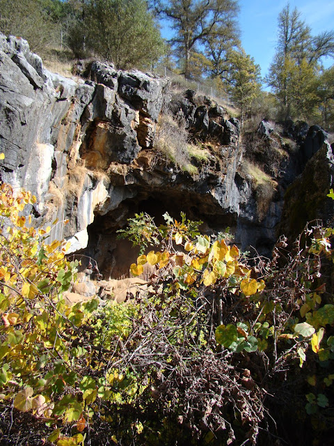
The interest of the cave is biological, historical, geological, and spiritual. That's a heavy load for any feature to live up to, but bear with me. The cavern opening is a large circular grotto about 100 feet (30 meters) wide, and about 35 to 62 feet deep (11-23 meters). The lake portal to the submerged caverns occupies about a quarter of the grotto floor. The overhanging walls cover about a third of the cavern floor. The cave provides a cool shelter and secure source of water during the hot dry part of the year. Animals, especially birds like swallows and owls live in the various folds of the rock. The water itself contains a few endemic arthropod species found nowhere else in the world. Fish were introduced at one time, but they didn't thrive and are gone now. Several large maple trees grow on the grotto floor. Their crowns provide the "bower" of the cave's name.
Source: http://www.karstportal.org/FileStorage/Caves_and_Karst/1969-v011-n003.pdf 

The cave was discovered early on during the Gold Rush, and when Yosemite Valley was discovered shortly after, one of the first access roads passed only a few yards from the grotto. It quickly grew popular as a cool rest stop during the long stage ride to Yosemite. John Muir paid a visit, and wrote admiringly of the cave:
Before noon we passed Bower Cave, a delightful marble palace, not dark and dripping, but filled with sunshine, which pours into it through its wide-open mouth facing the south. It has a fine, deep, clear little lake with mossy banks embowered with broad-leaved maples, all under ground, wholly unlike anything I have seen in the cave line even in Kentucky, where a large part of the State is honeycombed with caves. This curious specimen of  subterranean scenery is located on a belt of marble that is said to extend from the north end of the Range to the extreme south. Many other caves occur on the belt, but none like this, as far as I have learned, combining as it does sunny outdoor brightness and vegetation with the crystalline beauty of the underworld.
For a time a small hotel was operated nearby. The owners discovered the acoustics of the cave were excellent, so they constructed a bandstand and dance floor in the grotto. A windlass provided access at first, but a wood stairway was soon built. The party times continued into the 20th century. The property changed hands a number of times, eventually ending up in the Art Linkletter family (bonus points if you are old enough to remember him!). Someone was killed in a fall in the 1950s, so access to the cave ended over liability concerns.
Part of the bandstand still clings to the walls
A land exchange in 1991 brought the property under the administration of Stanislaus National Forest. Eventually access was restored through a permit system (one had to go to the closest forest service office for the combination to the lock on the gateway to the property). There were still worries about liability and danger from falls, so a newer gate has been constructing blocking access to the inner cave, but allowing views from the rim into the interior. Permits are no longer needed.
The cavern, as is true with most caves has developed in limestone, or more properly in this instance, marble. It is probably part of the Calaveras Complex, coral reefs and carbonate shelf deposits that were accreted to the western edge of the North American continent in late Mesozoic time (the age of the dinosaurs). Rocks within the Calaveras are late Paleozoic to early Mesozoic in age. The caverns formed when slightly acidic groundwater dissolved away the rock. The lake represents the level of groundwater in the region. In the long term, the lake will disappear as the nearby North Fork of the Merced River carves a deeper canyon and lowers the regional groundwater table. The grotto itself formed when the roof of the cave collapsed.
The cavern is unique enough that it was apparently part of the Miwok mythology. I say "apparently" because the sources date to anthropology studies in the late 1800s and early 1900s, and I haven't found any confirmation from current Miwok cultural sites on the web. I would love to hear if these stories are part of the Miwok tradition or not.

In any case, the story states that
A long time ago Too'-le the Evening Star lived at Oo'-tin [Bower Cave, on the Coulterville road to Yosemite]. He-le'-jah the Mountain Lion lived with him. They were chiefs and partners and had a room on the north side of the cave. There were other people here also To-lo'-mah the Wild Cat, Yu'-wel the Gray Fox, Kah'-kool the Raven, and many more.
The story continues with a legend of how the Raven and the early people learned to hunt deer. Some of the sources refer to the hole as a passageway by which humans entered the world. 
In any case, the cave is labeled on the AAA maps of the region, a few miles east of Greeley Hill. The trail is short, and the sights interesting. My sole visit was during the fall, and the trees were showing some nice colors.
The reference to "lost pictures" in the title of today's blog refers to the need to back up every picture file on multiple computers and external hard drives (no-brainer, right?). I took the pictures most of a decade ago, and replaced my laptop shortly afterward. I transferred all my files, but in the process, the pictures of Bower Cave disappeared somewhere. I've been through another three or four computers since then, and I've scoured the files on each of them, searching in vain for pictures I knew I had taken. That went on for years, but this week I tried one more time, and found them on a desktop that had fried her components, but I somehow managed to boot up, and there they were. And here they are. Enjoy, and if you get the chance, pay a visit to the cave on your way to Yosemite. And backup your files!
If you are interested in some of the research done at Bower Cave, check these sources:

http://www.karstportal.org/FileStorage/Caves_and_Karst/1969-v011-n003.pdf  Detailed study of the cave, part 1
http://www.karstportal.org/FileStorage/Caves_and_Karst/1969-v011-n004.pdf  Part 2, the vegetation
http://www.karstportal.org/FileStorage/Caves_and_Karst/1969-v011-n005.pdf  Part 3, the animals of the cave
Saturday, August 29, 2015

Vagabonding on Dangerous Ground: Our Tour of the Greatest National Park I Never Once Set Foot In

Photo by Mrs. Geotripper
The western slope of the Cascades Range is green. Very green. There are trees, shrubs, mosses, grasses, just about every kind photosynthesizing plant there is. This is due of course to the mountains themselves. They provide a barrier to incoming Pacific storms, causing the moist masses of air to rise and condense, with copious amounts of rain and snow falling to the ground. We were still in the realm of the rainforest.
Photo by Mrs. Geotripper
We were on the southbound road towards home following our exploration of the coastal belt of the Cascadia Subduction Zone. We were on vacation, but we happened to be in the region when the New Yorker article about the coming magnitude 9 earthquake hit the stands. All of the sudden, it was the talk of the town (if you were in Seattle or Portland, anyway). So our trip became a blog exploration of the fascinating geology and natural history of the region.
Photo by Mrs. Geotripper
We had spent nearly a week exploring the coastal belt of British Columbia, but now we were back over the border into northern Washington. We were inland now, following the chain of volcanoes that result from the melting of the rocks above the sinking slab in the subduction zone. We had already seen the Black Tusk and Mt. Garibaldi in Canada, and were now looking for the northernmost volcanoes in Washington. They were hard to find in the thick forest!
Photo by Mrs. Geotripper
We headed up the Skagit River to pay a visit to what I believe is the only remaining national park in the western contiguous states that I hadn't been to yet: North Cascades National Park. We found a space in the park campground, and moved on to the visitor center nearby. We weren't seeing many Cascades mountains or volcanoes. We also had not yet, and would not ever set foot in the national park during our visit.
Photo by Mrs. Geotripper
The thing is, North Cascades is a wilderness park. No roads reach the interior of the park, and the only road that crosses the range doesn't pass through park lands. The Skagit River has been dammed for power generation, and the valley between the north and south units of North Cascades is administered as the Ross Lake National Recreation Area. Our campground and the visitor center are both on Ross Lake lands. I wasn't sure how much of the park we would be able to see during our short visit. We didn't have time for long hikes, and the main road between the two units was ensconced in a steep gorge.

We could see a few peaks above the river, but they weren't the glacial alpine peaks I was expecting to see. It was deep forest everywhere. Where were the rocks?
Photo by Mrs. Geotripper
From the visitor center, a short nature trail promised a view. We walked over to take a look, and mountains appeared out of the greenery!
Photo by Mrs. Geotripper
The visitor center was on a bluff above the Skagit River, and the viewpoint provided a vista up Goodell Creek towards the Southern Picket Range. The Pickets rise to 8,000 feet, and expose granitic and metamorphic rocks that have been scoured by glaciation. Glaciers still cling to the highest ridges.
One peak really stood out from the others. It's called Pinnacle Peak, or "The Chopping Block", and has an elevation of 6,805 feet (2,704 meters). The summit area preserves a bit of the relatively flat pre-glacial topography. The ice age glaciers chipped around the edges, but didn't remove it all.
Having found some rocks at last, we started looking at the maps to see if we could find more. I had no idea what was about to come next! More next time...

Thursday, August 27, 2015

Vagabonding on Dangerous Ground: Seeing Volcanoes from the Inside Out at Siám' Smánit (Stawamus Chief)

It's one thing to talk about a subduction zone from the outside, where one might see an oceanic trench, or a chain of volcanoes. It's quite another to explore the convergent zone from the inside out, by, for instance, standing under the volcano. Miles below the volcano. That's what one gets to do along the lower stretches of the Sea to Sky Highway between Whistler and Vancouver in British Columbia.

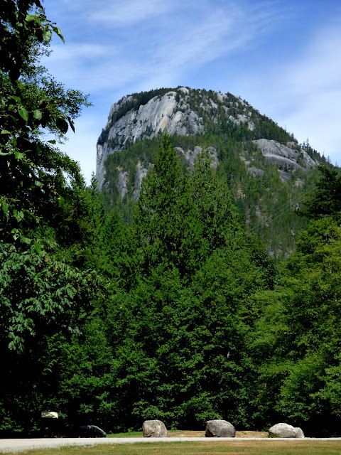
We were vagabonding our way through the landscapes of the Cascadia Subduction Zone between Northern California and the southern end of British Columbia. We were headed south towards home, but there were still some pretty intense sights ahead. As we drove down the Sea to Sky Highway back towards Vancouver, we had a chance to check out the awesome cliff of Siám' Smánit, Stawamus Chief at the head of Howe Sound. We got our first look of the immense cliff from several miles upstream at the Tantalus Overlook (below).
Stawamus Chief is a huge cliff and dome of granitic rock, specifically granodiorite (which chemically is a bit less rich in silica than actual granite). The chief has a height of 700 meters (2,297 feet), which is only a few hundred meters short of El Capitan in Yosemite National Park (900 meters, 3,000 feet). Interestingly, both names refer to "chiefs". The rock originated in magma chambers many kilometers below the surface of the Earth, underneath volcanoes that are presumed to have existed far above about 100 million years ago (the Cretaceous Period; dinosaurs would have wandered the slopes of these volcanoes). Tens of millions of years of erosion have removed the volcanoes and the many kilometers of intervening rock. We were quite literally standing within the internal plumbing of an ancient volcano!

One of the agents of erosion that has shaped Stawamus Chief was glaciation. We were at the head of Howe Sound, North America's southernmost glacial fjord, a spot where the ice stream was thousands of meters thick. The ice completely covered the "Chief" and eventually scoured and trimmed the edges of the huge rock.

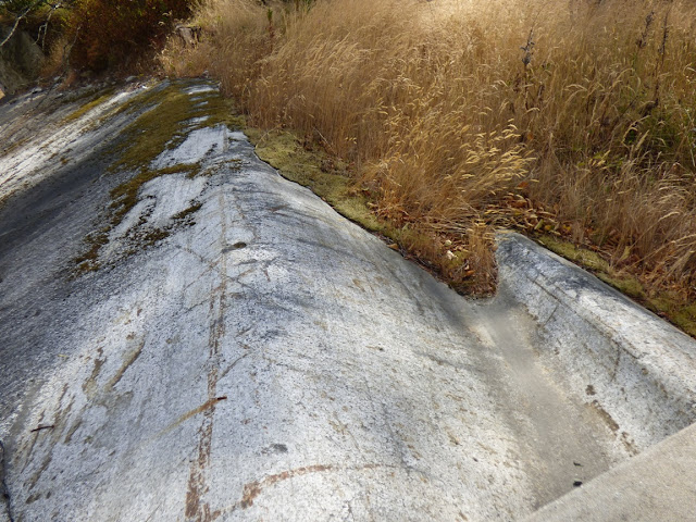
In the 12,000 years or so since the ice melted back, the scoured and polished surfaces of the rock were weathered away, or buried beneath rock debris. Fresh looking glacial surfaces can be hard to find at times, but the 2010 Winter Olympics provided some excellent exposures here at Stawamus. How? The organizers widened the highway, and constructed a pedestrian bridge that provided access to the provincial park for people parking to the north.
The slopes in the Stawamus area were covered with glacial till and outwash deposits that hid the scoured granite surfaces. Engineers cut a low pass through the till. but they realized that the loose debris would be a road hazard. They carted away the till, exposing the beautifully carved and polished surfaces underneath.

Some of the till was still visible on the south side of the highway (below).

From north of the bridge, even more of the immense cliff could be seen. The mountain attracts legions of rock climbers, and we could see several of them inching their way up the rock face.

It was getting late, and the vagabonders had made no plans for the night. We continued down the highway, eventually finding accommodations in North Vancouver. The next day we would be making the border crossing back into the United States, where new adventures awaited. More to come!

Sunday, August 23, 2015

Vagabonding on Dangerous Ground: Controversial Stone People, Fire and Ice, and an Olympic Legacy

A stone person stands on an outcrop up in Callaghan Creek a few kilometers west of Whistler in British Columbia. It has been called an inuksuk, although inunnguaq may be the more proper name (it's the difference between "something which acts for or performs the function of a person" and "imitation of a person"). The far north can be a featureless landscape with little in the way of landmarks, so the First Nation people like the Inuit used stone cairns for navigation and travel routes, and as signs for fishing sites, camps, hunting grounds, or places of spiritual importance. It is unclear if the human forms, the inunnguat (the plural form of the word), were used much prior to European colonization.
We were in Whistler, British Columbia, on our recent vagabonding adventure through the lands influenced by the Cascadia Subduction Zone, a place you may remember as the site of the 2010 Winter Olympics. Reminders were all over the place, including the rings and stage in the center of town. The slopes are covered with ski runs, and the highway from the coast, which we mentioned in a previous post, was widened and straightened, despite the ongoing threat of mass wasting.
The inunnguaq stood at the entrance to the Olympic venue in Callaghan Creek where the ski jump and biathlon events were held, and indeed, an inunnguaq was used as the symbol for the games in general. Now, I've loved the symbolism of the inunnguaq, and lots of my souvenirs of Canada include the image. But I've come to understand that it was of some concern to the First Nations people of Canada. It could be considered a sign of respect for the original people of Canada, but it could also be interpreted as a bit of cultural appropriation.

Some noted that the actual historical inuksuit (plural) rarely if ever took a human form. That practice may have not begun, as noted above, until European colonization. Others argued that the inuksuit were used by arctic First Nation peoples, whose lands were hundreds, even thousands of miles away from the Olympics site. I can see this as being the same as using a tepee as a symbol for the Los Angeles Olympics even though tepees were used by nations on the Great Plains, a thousand miles or more away. It's conceivable that a better symbol might have been a Thunderbird, a cultural icon of the Coast Salish people, especially since two prominent volcanic peaks in the Whistler area were seen as the perch for the animal (the Black Tusk, and Mt. Cayley, discussed below). Now, I'm no sociologist or anthropologist, and I certainly don't live in the region, so I'd love to hear some perspectives from those who are close to the issue.
But I loved seeing the ski jump! I've never seen one before in person, and I can say without any doubt whatsoever that you will never see me wearing skis on something like this. It is steeper than it looks, and I grew up watching that iconic crash from ABC's Wide World of Sports (the "agony of defeat"). It's still in use for training, but obviously not this time of year.
I would love to say that I fully research the landscapes that I explore beforehand, but this was vagabonding. I didn't know, other than a vague goal of reaching Canada, that we would make it as far as Whistler, and so I didn't look into the geology of Callaghan Creek where the Olympic venue was located. It turns out that the reach of Cascadia is more than I realized. There are several lesser-known, but potentially active volcanic centers to the north of Garibaldi. These include the Bridge River Cones, Mt. Meager, possible the Silverthrone Caldera, and across the valley from me at that moment, the Mt. Cayley Volcanic Field.
Source: "Garibaldi Volcanic Belt-en" by © Sémhur / Wikimedia Commons. Licensed under FAL via Commons - https://commons.wikimedia.org/wiki/File:Garibaldi_Volcanic_Belt-en.svg#/media/File:Garibaldi_Volcanic_Belt-en.svg

The main peaks of the volcanic field were hidden in the clouds (now there's a Pacific Northwest surprise), but we could see some of the glaciers that have formed on the flanks. The Mt. Cayley field has not erupted in some time, maybe 200,000 years, but hot springs and earthquake activity indicate the presence of magma beneath the complex. The Mt. Meagher field to the north erupted just 2,400 years ago.
The glacier between Metal Dome and Brandywine Mountain shows the state of the drought conditions this year and the ongoing loss of glacial ice in general from global warming. It was July, a time when a fair amount of snow should still cling to the peaks, but most of the ice visible is a dirty gray color. The gray is the old glacier ice, no longer hidden and protected by an insulating blanket of white snow. So the melting that is taking place is from the glacier itself, and these glaciers have been receding at an accelerating pace for decades now.
There weren't a lot of flowers out and about, but there were some beautiful ones here and there. No, I don't know many flower names. I'm a geologist, after all. They cover rocks.
There are a number of wonderful waterfalls in the area, the delightful results of volcanism and glaciation. Alexander Falls are just off the road in the Callaghan Valley downstream of the Olympic park.
Brandywine Falls are on the main Sea to Sky highway at Brandywine Falls Provincial Park. The 70 meter (200 foot) waterfall flows over the lip of a basalt lava outcrop. The falls are migrating upstream. The rock beneath the lip of the falls is softer and more easily eroded, so it is constantly wearing away and undercutting the cliff. Niagara Falls is migrating in the same manner.
We continued down the Sea to Sky Highway (Sky to Sea?), and saw some more incredible geology. It's coming in the next post...

Friday, August 21, 2015

Vagabonding on Dangerous Ground: Landing Place of the Thunderbird and the Grimy One, the Volcanoes of British Columbia

Nch'kay (Mt. Garibaldi) near Squamish, B.C.  Photo by Mrs. Geotripper
t'ak't'ak mu'yin tl'a in7in'a'xe7en and Nch'kay ("Landing Place of the Thunderbird" and "Grimy One") are the Squamish names for two of the most striking volcanoes in British Columbia. Much more recent colonizers refer to the mountains as Black Tusk and Mt. Garibaldi. I prefer the older names; we should name buildings after people, not mountains. They stand at the far north end of the Cascades Volcanic Arc, and although not as well known as their southern neighbors (at least to those of us in the lower 48), they are a potential threat. Mt. Garibaldi, in particular, is seismically active, although it has not had an eruption in about 10,000 years. Debris avalanches are an ever-present problem, however.
Garibaldi is 2,678 m (8,786 ft) in height, and is one of the more unique volcanoes of the Cascades. Much of the mountain erupted on top of a glacial ice sheet, so that when the glaciers melted back, around half of the edifice collapsed in a series of debris avalanches and mudflows. Mass wasting events have continued into modern times, and some of the slopes are considered dangerous enough to limit development in the areas affected. The oldest lava flows date to around 250,000 years ago and are composed of mostly silica-rich lavas such as dacite and rhyolite. The mountain doesn't show much evidence of more violent ash eruptions.
I was incredibly disappointed when clouds obscured our view of Garibaldi on our previous trip through the area, so our trip a few weeks ago was especially gratifying. As it turned out, we took just a few pictures from a pullout with lots of overhead wires, thinking we would get more the next day when we had a few more hours to spare. As luck would have it, the next day was more cloudy...such a surprise in the Pacific Northwest! These were our only pictures of the peak.

The story was very nearly the same with t'ak't'ak mu'yin tl'a in7in'a'xe7en (Black Tusk). We got some distant shots of the peak from the glacial fjord of Howe Sound. The next day we snapped a few pictures as clouds chased around the uniquely shaped summit. As noted in the title of the blog, the name refers to the Landing Place of the Thunderbird. The black color is said to result from the constant lightning strikes associated with the legendary bird.
t'ak't'ak mu'yin tl'a in7in'a'xe7en (Black Tusk), from the Whistler Olympic Venue. Photo by Mrs. Geotripper
The Tusk is 2,319 m (7,608 ft) and much older than Garibaldi. The main peak developed from eruptions around 1.1-1.3 million years ago, forming a stratovolcano. During a subsequent lull, most of the mountain eroded away. The last eruption took place around 170,000 years ago, so the peak is most likely extinct. Other cones in the area have been active in the last few tens of thousands of years.

I was extremely happy to have seen the volcanoes, but I was equally impressed with the other scenery as well. We spent a night in Whistler, and then did something significant: we turned around. The vagabonders were now starting for home, but there was plenty more to see. More posts to come!

Thursday, August 20, 2015

Cloud iridescence in Central California


I was out and about running errands in the late afternoon yesterday when I glanced at the sky, which was full of high-altitude clouds. The small opening in the clouds (just left of center) caught my eye because there were some colors visible. It appeared to be cloud iridescence, an optical phenomena caused by light diffracting through very small water or ice droplets in a thin layer of clouds.

Wednesday, August 19, 2015

Vagabonding on Dangerous Ground: Exploring North America's Southernmost Fjord

One of the nice things about vagabonding, traveling without a set itinerary, is that one can make allowances for weather. That's a major consideration with a journey through the Pacific Northwest. We stayed an extra day on Vancouver Island, letting a weak storm pass through the region, because I couldn't stand the thought of missing out again on seeing and exploring an extraordinary place, the southernmost fjord in North America.

We missed seeing much of the landscape in and around Howe Sound last year because we were traveling with a large group and had a precise schedule. An unusually powerful summer storm hit the region  as we traveled through. It caused flood damage across British Columbia and Alberta, but we mainly saw rain and very cloudy conditions. Needless to say, I was disappointed. Extremely, teeth-gratingly disappointed. My choice of travel locales on this trip was governed largely by the desire to see Howe Sound and the Sea to the Sky Highway between Vancouver and Whistler.

I reveled in the beauty of the storm-free weather as we boarded the ferry from Nanaimo on Vancouver Island to Horseshoe Bay in Howe Sound on the mainland. The water was sparkling in the sun, and views were practically unobstructed in all directions. We crossed the Strait of Georgia, the northern arm of the Salish Sea, and entered the mouth of Howe Sound. It was my first time seeing a glacial fjord (even though I was there the previous year).

A glacial fjord is simply a drowned glacial trough, a long coastal inlet that is lined by steep cliffs. Glaciers can erode valleys below sea level if the ice is thick enough, but many fjords formed by flooding caused by the rise of sea level that followed the end of the last ice age. The term is Norwegian, and of course Scandinavia is famous for spectacular fjords. But Howe Sound is no slouch when it comes to incredible scenery. And there's a hint of danger, too...
The hazards of living along a subduction zone change as one travels inland. We were now the width of a huge island and a large strait from the trench, so the direct shaking from gigantic earthquakes offshore would be somewhat lessened. But rockfalls and tsunamis would still have to be considered threats. Some tsunamis could even be generated within the fjord by rockfalls. In 1958 at Lituya Bay in Alaska, a quake-generated rockfall produced a gigantic spash that erased trees, rock and soil from the opposite slope to a height of 1,720 feet (520 m). The tsunami moved seaward with heights of between 100-300 feet, removing entire forests and killing several people unlucky enough to be in fishing boats at the mouth of the bay (although several survived the wave and provided eyewitness accounts of the extraordinary event).
Photo by Mrs. Geotripper

The existence of several important transportation corridors, both rails and highways, in Howe Sound has highlighted the dangers of mass wasting. There simply isn't much in the way of flat ground for the placing of rails or asphalt, so engineering problems abound. The original two lane highway was widened and straightened to ease traffic during the 2010 Winter Olympics. Problems with falling rocks and debris floods are constant, with an average of 405 events each year, and a death toll (since 1906) of 50 lives, although 37 of them were due to a single event, a horrific debris flow in 1921.
The other threat is volcanism. The slab of oceanic crust that is subducting off the coast carries water into the Earth's mantle, and a series of reactions lead to the melting of crustal rock. The magma rises to the surface, erupting out and forming a chain of volcanoes called a magmatic arc. Here, in British Columbia at Howe Sound, we were near the northern terminus of the Cascadia arc, and I was particularly anxious to have a look at Mt. Garibaldi and the Black Tusk. I had a brief view of the "tusk", an eroded cinder cone, as we sailed into the sound. There will be a bit more on the volcanoes in a future post.
We drove up the narrow highway and made a brief stop at Porteau Cove Provincial Park. We stopped there last year, but mostly had a view of some rocks up close, and fog. On this day, we had a dramatic view of the sound, and the surrounding glacier-covered peaks.
The water had changed from a dark blue to a turquoise hue. The reason had to do with the glaciers on the high peaks above us. As the ice grinds away at the rock, a fine silt/clay material results, and is carried in the meltwater to the sound below. The finest clay particles can remain in suspension for weeks or months, and that is what produces the unique color of the water in the upper part of the sound.
The main trunk glacier that produced Howe Sound was able to cut far deeper than the smaller tributary glaciers, so the side canyons ended up perched high up on the rim of the main valley. Shannon Falls is an example of one of these hanging valleys. It makes a dramatic cascading drop of  1,100 feet (335 meters) onto the valley floor at the head of the sound.
We reached the upper end of Howe Sound at the town of Squamish, and started the grade up into the mountains at Whistler. At a roadside viewpoint, we stopped and looked back at the head of Howe Sound. It was a much different place than the one we saw last year!
In case you were wondering what we did see last year, here is a shot from Porteau Cove in 2014.
And this was Shannon Falls in 2014. The fog had lifted a bit, so we actually saw the falls back then. I was struck by how feeble the falls were this summer. The drought extends far beyond California...