The middle parts of the Sierra Nevada are kind of the great unknown of the Sierra Nevada (at least to me, but I suspect many others, too). It's not that the region between the mostly alpine national parks and the highly touristy Mother Lode is a wilderness. It's quite the opposite, with an intense history of logging, mining, dam-building, and ranching. Oh, and the elimination of the First Nations people who used to live there, so other people could build their summer cabins and the like. It's just that region one passes through while rushing to Yosemite or Lake Tahoe.
It turns out that a great many interesting places in the middle reaches of the Sierra Nevada are worthy of investigation. Deep river canyons, waterfalls, fragrant rich forests, and caverns. Hundreds of caverns!
California is not famous for its caves, but it has some world-class examples, including Lilburn Cave in Kings Canyon National Park. Lilburn has just over 20 miles of passageways, making it the 28th longest in the United States (there are more than 1,100 caves in the U.S. over a mile in length).
There is an interesting cave uphill from the Mother Lode in the vicinity of Coulterville and Greeley Hill just west of Yosemite National Park, interesting not in the sense that it's fun to explore because one cannot explore it. Well, you could, but you would have to participate in one of the most dangerous sports possible, cavern scuba diving. That's a pursuit with few margins for error. The entire cave beyond the entrance is submerged in water. It's called Bower Cave.

The interest of the cave is biological, historical, geological, and spiritual. That's a heavy load for any feature to live up to, but bear with me. The cavern opening is a large circular grotto about 100 feet (30 meters) wide, and about 35 to 62 feet deep (11-23 meters). The lake portal to the submerged caverns occupies about a quarter of the grotto floor. The overhanging walls cover about a third of the cavern floor. The cave provides a cool shelter and secure source of water during the hot dry part of the year. Animals, especially birds like swallows and owls live in the various folds of the rock. The water itself contains a few endemic arthropod species found nowhere else in the world. Fish were introduced at one time, but they didn't thrive and are gone now. Several large maple trees grow on the grotto floor. Their crowns provide the "bower" of the cave's name.
The cave was discovered early on during the Gold Rush, and when Yosemite Valley was discovered shortly after, one of the first access roads passed only a few yards from the grotto. It quickly grew popular as a cool rest stop during the long stage ride to Yosemite. John Muir paid a visit, and
wrote admiringly of the cave:
Before noon we passed Bower Cave, a delightful marble palace, not dark and dripping, but filled with sunshine, which pours into it through
its wide-open mouth facing the south. It has a fine, deep, clear little
lake with mossy banks embowered with broad-leaved maples, all under
ground, wholly unlike anything I have seen in the cave line even in
Kentucky, where a large part of the State is honeycombed with caves.
This curious specimen of subterranean scenery is located on a belt of
marble that is said to extend from the north end of the Range to the
extreme south. Many other caves occur on the belt, but none like this,
as far as I have learned, combining as it does sunny outdoor brightness
and vegetation with the crystalline beauty of the underworld.
For a time a small hotel was operated nearby. The owners discovered the acoustics of the cave were excellent, so they constructed a bandstand and dance floor in the grotto. A windlass provided access at first, but a wood stairway was soon built. The party times continued into the 20th century. The property changed hands a number of times, eventually ending up in the Art Linkletter family (bonus points if you are old enough to remember him!). Someone was killed in a fall in the 1950s, so access to the cave ended over liability concerns.
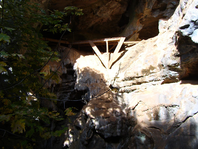 |
| Part of the bandstand still clings to the walls |
A land exchange in 1991 brought the property under the administration of Stanislaus National Forest. Eventually access was restored through a permit system (one had to go to the closest forest service office for the combination to the lock on the gateway to the property). There were still worries about liability and danger from falls, so a newer gate has been constructing blocking access to the inner cave, but allowing views from the rim into the interior. Permits are no longer needed.

The cavern, as is true with most caves has developed in limestone, or more properly in this instance, marble. It is probably part of the Calaveras Complex, coral reefs and carbonate shelf deposits that were accreted to the western edge of the North American continent in late Mesozoic time (the age of the dinosaurs). Rocks within the Calaveras are late Paleozoic to early Mesozoic in age. The caverns formed when slightly acidic groundwater dissolved away the rock. The lake represents the level of groundwater in the region. In the long term, the lake will disappear as the nearby North Fork of the Merced River carves a deeper canyon and lowers the regional groundwater table. The grotto itself formed when the roof of the cave collapsed.

The cavern is unique enough that it was apparently part of the Miwok mythology. I say "apparently" because the sources date to anthropology studies in the late 1800s and early 1900s, and I haven't found any confirmation from current Miwok cultural sites on the web. I would love to hear if these stories are part of the Miwok tradition or not.
In any case,
the story states that
A long time ago Too'-le the Evening Star lived at Oo'-tin [Bower Cave, on the Coulterville road to Yosemite]. He-le'-jah
the Mountain Lion lived with him. They were chiefs and partners and had
a room on the north side of the cave. There were other people here also
To-lo'-mah the Wild Cat, Yu'-wel the Gray Fox, Kah'-kool the Raven, and many more.
The story continues with a legend of how the Raven and the early people learned to hunt deer. Some of the sources refer to the hole as a passageway by which humans entered the world.
In any case, the cave is labeled on the AAA maps of the region, a few miles east of Greeley Hill. The trail is short, and the sights interesting. My sole visit was during the fall, and the trees were showing some nice colors.

The reference to "lost pictures" in the title of today's blog refers to the need to back up every picture file on multiple computers and external hard drives (no-brainer, right?). I took the pictures most of a decade ago, and replaced my laptop shortly afterward. I transferred all my files, but in the process, the pictures of Bower Cave disappeared somewhere. I've been through another three or four computers since then, and I've scoured the files on each of them, searching in vain for pictures I knew I had taken. That went on for years, but this week I tried one more time, and found them on a desktop that had fried her components, but I somehow managed to boot up, and there they were. And here they are. Enjoy, and if you get the chance, pay a visit to the cave on your way to Yosemite. And backup your files!
If you are interested in some of the research done at Bower Cave, check these sources:
http://www.karstportal.org/FileStorage/Caves_and_Karst/1969-v011-n003.pdf Detailed study of the cave, part 1
http://www.karstportal.org/FileStorage/Caves_and_Karst/1969-v011-n004.pdf Part 2, the vegetation
http://www.karstportal.org/FileStorage/Caves_and_Karst/1969-v011-n005.pdf Part 3, the animals of the cave


