Showing posts with label Shoshone. Show all posts

Thursday, February 20, 2025

An "Extinct" Fish Finds Life Again in a Parched Desert: The Saga of the Shoshone Pupfish

The pupfish habitat at the springs in Shoshone, east of Death Valley National Park
Of all the things one might look for while exploring intense desert environments, what is the most unlikely form of life you would expect to encounter? Fish of course. It's practically an oxymoron to use the term "desert fish". But in the harsh desert environments of eastern California and western Nevada, there are indeed fish. And not just a single species, but around a dozen species and subspecies. There are nine distinct populations of the Cyprinodon Pupfish, three species of Speckled Dace, and a Poolfish. How they survive today, and how they got there in the first place is a fascinating story.

How they survive is not difficult to understand: despite the aridity of the California desert, there are sources of water. There are permanent springs and pools of water scattered all around Death Valley and the Amargosa River Basin, and the fish have adapted to life in waters that might be hot, cold, fresh, or salty.


How they got there in the first place is a little trickier to understand. Our climate has been subject to huge variations over the last two million years, and more than a dozen times, it got much cooler and glaciers developed and expanded, especially in the Sierra Nevada mountains. Some of the meltwater from those glaciers flowed into the deserts of the Basin and Range province and accumulated in huge freshwater lakes. As a lake basin filled (such as at Mono or Owens Lake), it spilled over into the next lake basin until a network of lakes extended from the Sierra Nevada to Death Valley. The Amargosa River flowed through western Nevada, also ending in Death Valley. So there was plenty of water once upon a time.

At some point in time, a connection was made with the Colorado River, and fish were able to make their way into the network of freshwater lakes, and they thrived. But as each glacial stage ended, the lakes would begin drying up and most of the fish lost their habitat and went extinct. But those very few species that could adapt quickly enough took refuge in the rare and isolated springs and pools. A few, including the Lahontan Cutthroat Trout survived in the cold streams, lakes and rivers of the eastern Sierra Nevada. Those trapped in saline waters had to adapt to the salty conditions. Some fish adapted to high temperatures,  and unlike pretty much any other fish in the world can survive in water that reaches a hundred degrees or more.

One of my very few photos of the Devils Hole Pupfish, taken from around 100 feet away.

Perhaps the most famous of these fish is the Devils Hole Pupfish (above), found in a single cavern opening in the Ash Meadows National Wildlife Refuge (the spring officially lies in an outlier of Death Valley National Park). Their story is compelling, but they are not the fish I'm discussing today. You can read about them if you wish here or here.

 
The various populations of pupfish survived for thousands of years in isolation from human developments. But the colonization and occupation of the desert by miners and ranchers spelled doom for some of them. One species, the Tecopa Pupfish, was driven extinct pretty much in an afternoon when pipes were installed at the one spring where they lived. A similar fate apparently happened to a different subspecies, the Shoshone Pupfish (Cyprinodon nevadensis shoshone) in the 1960s as springs in that area were developed for domestic use at the village of Shoshone. The species was declared extinct in 1969, as none could be found anywhere.
Improbably, a small population of the fish actually survived the devastation of their original habitat by taking refuge in a nearby irrigation ditch, unnoticed by anyone. In 1986 they were rediscovered, and a cooperative effort by the private landowner and several environmental organizations resulted in a resurrected habitat. This habitat was actually expanded to three pools and some artificial off-site refuges as well. Despite visiting Shoshone yearly for the last three decades, I never heard about the efforts being made on behalf of the fish's well-being. 
That changed last week when I found out that a nature trail had been constructed, and interpretive signs posted that allowed for some close viewing of the diminutive fish (as well as another highly endangered creature, the Amargosa Vole). The site also serves as an excellent habitat for a large variety of birds, and we saw Western Bluebirds, Yellow-rumped Warblers, White-crowned Sparrows, a Costa's Hummingbird (a life-lister for me) and we could hear Verdins chattering away in the brush.
The trail is just off the main highway in Shoshone, and the locals seem proud of the efforts and can easily point the way to the trailhead, next to the local school. If you ever travel to Death Valley from the east, you can't miss the town. It's the only gas station and food stop for many miles. Don't forget to stop in at the local museum for a look at the Columbia Mammoth fossils on display inside!


Saturday, May 30, 2015

How Strange Has the Weather Been? This was the Death Valley Region only a week ago

Zabriskie Point in late May. It's usually over 100 degrees and sunny this time of year.
The weather was a bit...off last week as we hit the road to the southwest. We meant to drive over Tioga Pass, and made it to Crane Flat, only to find the pass was closed by snow. We headed back down to the Central Valley and crossed the mountains at Tehachapi. From there we arrived in Death Valley for two nights of camping. It's late May, the temperature is usually well over 100 degrees, but this is what greeted us at Furnace Creek:

We actually needed a light blanket in our tent the first night. We followed Highway 190 east to Death Valley Junction, trying to thread our way between storms. We watched the gully-washer turn Eagle Mountain into shadows.

We passed a small herd of wild horses near Death Valley Junction. They seemed unperturbed by the downpour.


The town of Shoshone is a small outpost of civilization east of Death Valley. It was wet too. There has been odd weather across the country of late. Seeing May snow in the Death Valley high country and rain across the valley floor certainly fit the pattern. I have no conclusions to draw from this, but it's strange to see droughts and record heat in California and the Alaskan rainforest, along with intense flooding in Texas and Oklahoma. Strange and interesting...

Friday, March 13, 2015

A Roadcut as a Microcosm of a Province - The Charlie Brown Outcrop


A lot of geologic knowledge is gleaned from roadcuts. In less arid regions, vegetation and soil cover is so thick that roadcuts provide essentially the only information about the underlying geology. That isn't as much of a problem in the Basin and Range Province of Nevada, eastern California, and western Utah. It's a dry land, and the rocks stand out in bold relief. And with flat valley floors, roads don't need to be carved through solid rock all that often. But sometimes roads have to cross the mountain ranges, and there they are. A peek at the interior of a mountain range.
Some outcrops are more instructive than others, and once in a while, a road crew uncovers something spectacular. That's what happened when Highway 178, the Charles Brown Highway, was constructed over the Resting Springs Range from Shoshone, California to Pahrump, Nevada. It's about three or four miles east of Shoshone, and you can hardly miss it. There is a huge black "thing" climbing the slope that grabs your attention, and brings any geologist's foot down on the brakes. Caltrans has kindly provided a wide turnout, no doubt because of the congestion that occurs here during field studies season.
The view from the pullout takes in a broken land, as Professor Frank DeCourten has called it. The tan hills of the Resting Spring Range lie in foreground. Across the Amargosa "River" Valley is another ridge of twisted and broken rock, the Amargosa Range, then the Greenwaters, and on the skyline, the Black Mountains. Beyond lies the deep trough of Death Valley. This is a land with a violent history that has included dozens, if not hundreds of astoundingly huge volcanic eruptions, any one of which, if they happened today, could bring about the end of human civilization (through the disruption of agricultural production). The land was stretched until the crust snapped and huge fault systems developed, with deep fault valleys (grabens) and high mountain ranges (horsts). Whatever river systems existed were disrupted (one of them may have been the ancestral Colorado River). Today, even if there were water to flow, none would flow to the sea. The rivers would end in the adjacent valley, forming large lakes.

The Charlie Brown Outcrop, as it is informally known, encapsulates many elements of the story.
There are really three stories told in this exposure, that of distant ash eruptions, a violent eruption close by, and earthquakes with associated mountain-building.

Distant ash explosions sent clouds of pulverized pumice shards that landed in lake beds and valley bottoms. The exposures took various hues due to oxidation of metals, mostly iron, in the ash beds. When major fault systems broke up the landscape, many smaller subsidiary faults shifted a few inches or feet. The ash beds and faults are nicely exposed on the right side of the outcrop. Pictures of this fault grace many geology textbooks.

The dark layer also tells of violent events. A nearby ash eruption produced very hot clouds of incandescent rock particles that landed in a thick layer, and remelted. Such rocks are called welded tuff or ignimbrite. The black layer is the most completely melted rock, and is called a vitrophyre. In essence it is obsidian, but not of a quality that one would want to make arrowheads with.
Photo by Mrs. Geotripper
It's all quite a puzzle for our field students who are seeing these kinds of features for the first time. We introduce the classification of faults, talk a bit about pyroclastic rocks, and then they sketch out the relationships that they can see. They give their best interpretation of what happened here, and the nice thing is, a lot of them find out that they can do a pretty fair job of discerning the story revealed by the rocks.

The idea of calling this the story of the Basin and Range in a roadcut was most assuredly not my idea. It comes from a short study of the rocks by Bennie Troxel and E. Heydari in 1982:

Troxel, B. W., and Heydari, E., 1982, Basin and Range geology in a road cut, in Cooper, J. D., Troxel, B. W., and Wright, L. A., eds., Geology of selected areas in the San Bernardino Mountains, western Mojave Desert and southern Great Basin, California: Geological Society of America, Guidebook, p. 91 – 96.

Sunday, March 18, 2012

Strangers in a Strange Land: The Value of a Road Cut

As teachers, we hope to go in the field with our students in hopes that they can related cartoons in a textbook with exposures in the real world.  Then we get there, and we find together that sometimes the "field" does not readily give up secrets. There is this phenomena called "weathering" that renders rocks indistinguishable from other rocks. Take the above scene, from an area near Shoshone, a little village east of Death Valley National Park. If we were back east somewhere, there would be a complete covering of green organic material that biologists call trees and shrubs covering most of the rocks, rendering identification and interpretation practically impossible (and believe me, I appreciate and admire those who figured out the story of places like the Appalachians and the Canadian Shield).

But even here, where the climate is so dry that plants can scarcely survive, the rocks are still obscured. The geologists who have training in field methods can make sense of this sort of landscape, but students who are in the field for the first time can feel intimidated. A few gray rocks in the foreground, some tan colored rocks across the small valley, and a difficult time understanding how they relate to each other. It would be a challenge. But once in a while, the department of transportation does us a real favor. They want to make their roads straighter, and when nature hasn't cooperated by eroding into straight lines, they make roadcuts for us.

For instance, if the scene shown above doesn't look all that remarkable, look what happens when you turn around...
That's an outcrop! This is one of those sweet times when the real world looks a lot like the textbook diagrams, so the students get to do some basic interpretation of rock relationships without having to visualize obscured contact lines. Many field trips visit this outcrop, so much so that the department of transportation has left behind a parking area across the street that is big enough to accept even buses.

So, what would you do with your students here?

Oh, and by the way, all you mineralogists out there, what do you think this nice botryoidal mineral might be? I have my strong suspicions about a relatively simple answer, but I've just assumed it for a long time. The host rock is a rhyolite tuff, and hot vapors and groundwater have probably both influenced the outcrop.

Saturday, February 19, 2011

Death Valley Days: The Second Day - We Dodge a Bullet

The biggest, baddest storms still find heartbreak in the barren jagged peaks of the Basin and Range Province, and especially Death Valley. Last night we awaited the onslaught of winds and a 100% chance of rain, but the mountain barriers of the Panamint and Cottonwood Mountains absorbed most of the storm's moisture, and we had just a spritz of rain in our camp at Stovepipe. Furnace Creek got a bit more, 0.14 inches, but all in all we dodged a very big bullet, aside from some inconveniently heavy winds that destroyed one of the student's tents overnight. Morning arrived with a wonderful moonset over the Cottonwoods.
As we hit the road, we realized the storm really was past, as sunshine lit up the Panamint Mountains on the east side of Death Valley. If you are noticing the snow, it's not an unusual occurrence in the park, considering the Panamints top out at over 11,000 feet in elevation. The valley floor in the foreground of the picture is below sea level. Death Valley has some of the highest relief of any place in the United States (the difference between the highest and lowest points). The rugged slopes are composed of Paleozoic and Proterozoic sedimentary rocks, mostly carbonates, with a healthy mix of intrusive granites and older metamorphic rocks

It would be inaccurate to say that the flower blooms have started in earnest, but we found a few here and there, and they added a nice splash of color to the desert.
We made stops at some fault exposures east of the park near Shoshone (the 'Charlie Brown outcrop'), and headed over the Black Mountains into the southern reaches of the Death Valley graben. We checked out the Amargosa Chaos exposures at Exclamation Point, the Pahrump Group near Ashford Mills, the fault scarps, offset cinder cone and wave cut terraces near Shoreline Butte, and I took...no pictures! I was busy...eh...teaching and stuff.
We made a stop at Mormon Point and took in a couple of Death Valley's enigmatic features, the turtleback faults. These are massive dome-shaped fault surfaces whose origins are debated, but they are composed of deep crustal rocks that have been metamorphosed into gneiss and schist. The rugged exposures reveal collisions of land masses around 1.7 billion years ago, and are the oldest rocks in the park.
Mudflows and flashfloods have scattered large boulders of the ancient rock across the valley floor and are a treat to explore. One huge boulder (below) contained huge crystals of black hornblende 3-4 inches long.
We of course had to do the touristy thing and visited the lowest point in the western hemisphere at Badwater. The actual lowest point is out on the salt flats a mile or two away, but what's a foot or two between friends? People were walking out onto the freshest salt exposures.
The afternoon sun was sinking fast, but we had one more thing we wanted to do...
It's also a touristy thing too, but we wanted to see the flaming colors of the sunset on the Artists Palette. We drove up Artist Drive as fast as we were able, and we didn't quite get to the Palette, but we did stop and get a nice panorama of the other volcanic rocks at the north end of the Black Mountains.
Conditions are a lot calmer tonight, so hopefully no rain or heavy winds. Two nights of that and I'll have a tired class, and we have lots of great stuff to do tomorrow!

Thursday, August 20, 2009

Geological Conservancy?


Andrew Alden, as he often is, is right on top of a great idea, a proposal for a Geological Conservancy, modeled along the lines of the well-known Nature Conservancy, and less well-known groups like the Archaeology Conservancy. The proposal is outlined in some detail here, in the SIPES Quarterly. I think the idea is well worth exploring. So many geologically significant outcrops and roadcuts lie outside of national parks or monuments and are constantly threatened with destruction. Roadcuts are especially vulnerable, as road maintenance crews are often ignorant of the importance of the rock faces under their care. I've illustrated three famous sites in California that fall into this category.

The first is the Shoshone Roadcut, often referred to as the Charlie Brown Outcrop (the Charles E. Brown Highway). It illustrates in a wonderful manner the relationships of extensional faults and ash flow tuffs/air fall tuffs in the Basin and Range Province. The surrounding lands are administered by the Bureau of Land Management.

The second picture is the Sherwin Summit roadcut (the "Big Pumice Cut") that settled the question of the age of the Sherwin Glaciation of the Sierra Nevada in relation to the well-dated eruption of the Bishop Tuff. It is a cherished outcrop to legions of California geology students, but at various times road groomers have threatened to cover the outcrop with vegetation, or alter itto a great degree. I believe the land behind the outcrop is managed by the U.S. Forest Service.

The third photo is one of our local special outcrops, where quartz and mariposite veins of California's Mother Lode cross a major highway near Coulterville. The site illustrates the relationships of the ores with the surrounding metamorphic rocks which formed within a subduction zone complex in Mesozoic time. One would need access to an underground mine to have an equivalent view of these complex relationships. The land back of the highway is privately owned.

These kinds of outcrops don't have the natural constituency that places under the protection of the Nature Conservancy often have. They are not always scenic, and they generally don't form a critical habitat for rare plants or animals. But they do offer an invaluable educational experience for learning the basic principles of geology. They should have some form of protection, and a conservancy might be a good approach.

I worry a little about publicizing some of these places, though. Outside Las Vegas, at Frenchman Mountain, the UNLV geology department spent years and lots of money on building some wonderful monuments describing the Great Unconformity between Proterozoic gneisses and Cambrian sandstones. They were vandalized almost right away, and people continue to dump rubbish in the canyon (the site is periously close to a tsunami of housing developments on the northeast side of the city).

What do you think? Is this worth pursuing? How has the ability and resources to administer such a program?

What kinds of places exist in your area that deserve some kind of recognition and protection that they are not receiving now?

Wednesday, March 5, 2008

Picture of the Day - A Great Outcrop, Part 3


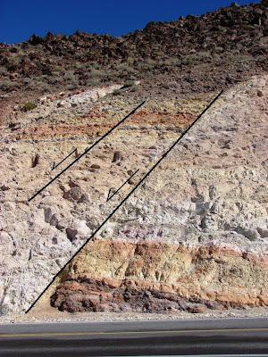
Apologies to Ron and Silver Fox for the delay revisiting last weekend's outcrop; all that death defying stuff distracted me. This is a well-known stop for many Death Valley field trippers at the south end of the Resting Springs Mountains just west of Shoshone. It is a marvelous site for teaching about faulting and aspects of volcanism. The prominent fault appears at first glance to be a classic reverse fault because of a tendency in one's mind to link the orange layers. The layer in the footwall (right) includes a dark lavender layer that is not present in the headwall, and thus the layers do not correlate. The smaller fault shows the correct offset.


The rocks in the outcrop are primarily air fall tuffs, although a megabreccia is exposed nearby. The rocks have clearly been tilted a bit.


Once my students finish looking at and sketching the faults, their attention is drawn to the dark layer to the left. It is a vitrophyre, a rhyolite ash flow that was so hot when it was erupted that it remelted to obsidian in the middle. A close inspection of the outcrop shows pumice pyroclasts that are progressively flattened towards the dark obsidian in the center of the flow. The upper part of the flow shows vesicularity as gases moved upwards during the cooling phase. Apparently the flow is in the original orientation; it was not tilted, but was instead plastered against a sloping hillside. The vugs contain interesting minerals, including zeolites and other silicates.


I wasn't so smart with this outcrop the first time I saw it. My instructor convinced us first that it was a reverse fault next to a coal seam, and then pointed out the inconsistency of the fault interpretation. Then it was hmmm? maybe not a coal seam, could it be a lava flow? Was it a dike? Oh dear, maybe we would have to figure out this whole thing ourselves.


Researchers much more talented then myself have published a tract about the outcrop that has been reprinted and is on sale at the Shoshone museum, which is also worth a stop if you are in the region. They have an excellent exhibit on the mammoths and other creatures that have been excavated in the region. Check it out!
  • Troxel, B.W., and Heydari, E., 1982, Basin and Range geology in a roadcut, in Cooper, John D., Troxel, Bennie W., and Wright, Lauren A., Editors, Geology of selected areas in the San Bernardino Mountains, Western Mojave Desert, and southern Great Basin, California: Volume and guidebook for field trip no. 9, 78th Anniversary Meeting of Cordilleran Section, Geological Society of America: Shoshone CA 92384, Death Valley Publishing Company, p. 91-96, 202 p.