Saturday, April 29, 2017

Redux: George Lucas Had It Wrong. A Day of Fierce Pride at Modesto Junior College


It's funny how the same thoughts can move through one's head during an event, even when the events are separated by years. My mind wandered just a little bit during our graduation ceremony tonight, because that can happen while 700-800 names are read off and people march across a stage. I wrote an entire blog post in my head. It had to do with 700 or 800 moments of pride being experienced this day: dreams fulfilled by young students attending college for the first time in their family's history, by middle-aged people dreaming of a new career, and seniors discovering that life can start over. These were the people I worked with, joked with, and sometimes cried with. They have been trying to remake their lives, and I continue to be given the privilege of helping them to achieve those dreams. So I did. I wrote a whole blog post in my head honoring their accomplishments, because for all the pride they were experiencing in that moment, I was also feeling great pride that I was able to be a part of their life adventure.

Then, I got home and found I had already written it! Exactly one year ago today. So here it is...I created it twice (thank goodness for cut and paste)!

--------------------------------------

No, I'm not talking about the prequels to Star Wars! It was something much earlier. People could be forgiven for not knowing this, but Star Wars was not George Lucas's first successful film. He was known for another great movie, American Graffiti, a semi-autobiographical film that recalled his days as a young man in Modesto, California. Yes, Lucas is perhaps our most famous native son. He also attended Modesto Junior College for a time.

So what was it that he got wrong? It was a fairly minor plot point, but in the movie, the two friends Curt and Steve were on the same pathways for their lives. They were planning to leave town to attend a "northeastern" college (let's presume an Ivy League school), but after a series of events over the space of one long night, Steve is convinced to stay in Modesto, attending the "junior" college, while Curt heads off to great success, and was eventually a writer living in Canada. Steve ended up selling insurance in Modesto.

What's wrong with this picture? It was the insinuation that attending a community college was somehow a lesser option for achieving success, that it is in some way a second-rate education. As I sat proudly through our graduation ceremony tonight, I would fiercely argue that getting a degree at a community college is a wonderful achievement, and that I would proudly put my students up against any Ivy League student at the two-year mark in their academic career.

It doesn't take long to realize that a lot of (but certainly not all) the students at a Harvard or Yale are children of privilege, people who have never really had to struggle to get ahead in life. They started in private upscale schools, got in on the fast-track to an Ivy League school with the best preparation possible. It's hardly a surprise that they would excel and succeed.

The students I work with come from many different backgrounds, and most of them are poor and disadvantaged. They come from many cultures. Our elementary and secondary schools are underfunded and sometimes dangerous, and alcoholism and drug use are epidemic in our region. The kids in our schools have the decks stacked against them at every turn. They come to us unprepared and unskilled. We have veterans suffering from PTSD, abused spouses, and laid-off laborers. We have huge numbers of people who are the first in their families to ever attend college. We have resources at our school, but sometimes the challenges facing our students are overwhelming. And yet these students persist, and they fight, and they cry, and fail, and then they come back again. And in the end they master the skills required to pass their classes. When you see a group of these students decked out in blue robes, and receiving an AA or AS degree, you are looking at some of the most successful people in the world.

If you are an employer, and you see a community college on the resume of a potential employee, you are looking at a person with persistence, stamina, and an incredible work ethic. They've been through impossible challenges and they've succeeded.

I couldn't be more proud of my students on this great day.

Friday, April 28, 2017

The Alpha and Omega of the Wildflower Season at the Red Hills ACEC

With some careful selective editing one can make it look like the superbloom is continuing in the Red Hills Area of Critical Environmental Concern, but alas the bloom is beginning to fade. We drove up there today and I was standing in this field of Monkeyflowers when a car pulled up, looking for the Red Hills. I was said he was in the middle of it and he seemed mildly disappointed, but his family jumped out for some pictures anyway. The flowers were there, concentrated along Six-bit Creek, but it just wasn't the same show. Was I disappointed? Of course not!
A bit of searching revealed some Paintbrush on the trail above the river.
One thing that changes as the flowers fade is that the rocks become more visible. If you haven't seen some of my posts in the past, the Red Hills Area of Critical Environmental Concern (only a bureaucrat could come up with a name like that!) is a landscape of about 7,000 acres in the Sierra Nevada foothills just west of the village of Chinese Camp. It exposes ultramafic rocks (serpentine and peridotite derived from the Earth's mantle) with a chemistry that precludes the development of fertile soils (they lack some critical nutrients, but include a few toxic elements as well). As a result most normal foothill species cannot thrive. Because of the relatively barren look of the place, it was abused for years as a motorcycle riding area and dumping ground. But hard soil conditions force plants to adapt. It turned out that the Red Hills sheltered dozens of serpentine tolerant plants that are rare elsewhere, and some of the plants are endangered, in part because their habitat is so limited.
Volunteers cleaned up the garbage, and the Bureau of Land Management began developing trails and a picnic area along with interpretive signage. For most of the year, the rocks lie exposed to the intense sunlight, but during the rainy season, the area can explode with unique wildflower species. We caught the early part of the season in March (the Alpha), and today we were witnessing the end (the Omega).
I'm an amateur at identifying birds, but I've gotten better at it and can identify most of the common ones in my area. But with wildflowers I'm hopeless. My memory for wildflower names is barely better than Dory in Finding Nemo. The nice thing about that, I guess, is that every year it is like discovering the species for the first time (even if it is the tenth). I thought I'd never seen the White Hyacinth before (below), but I'll bet my old albums of the Red Hills are full of pictures of them.

It isn't just the flowers that can be rare and unique. This arid landscape also hosts an endangered vertebrate species as well, and it's a surprise. It's a fish. That's extraordinary, knowing how hot and dry this place becomes in the summer. Somehow, the Red Hills Roach (Lavinia symmetricus) survives in a few small spring-fed pools in some of the creeks in the preserve. There were some serious concerns about whether they could survive the extended drought, but they did okay. I got some clumsy pictures on our earlier trip (below).
The Red Hills Roach, an endemic fish found only in this part of the Sierra Mother Lode

There isn't much time left before the flowers begin to fade away for another hot summer. All is not lost of course, as the wildflower season will probably last all summer and into the fall, since it is going to take about that long to melt all the snow that has fallen this year. If you want to see flowers in the coming months, just head higher into the mountains! But stop by the Red Hills for a few moments to see rocks that began their journey many tens of miles, maybe hundreds of miles down in the crust and mantle of Planet Earth. They are fascinating.

Tuesday, April 25, 2017

Why Science Matters: March For Science 2017

A bank robber can make a lot of arguments about why he or she should be allowed to rob a bank. "The money in the bank is just sitting there, it's not aiding the economy by being circulated", or "By taking this money and spending it, I'll be creating jobs", or "But I'll give some of the money to charities". A bank president, and for that matter, the people who have been robbed, would never agree that this justifies stealing the money. So why would anyone acquiesce their right to clean water and air, safe food and drugs, and their very environment to those who would steal those things from them? Sometimes it's because they are kept in the dark about the dangers that they face. Ignorance is a valuable tool for those who would profit off of our birthright to clean air and water, and a livable environment.

Sometimes the dangers in our environment are obvious. Earthquakes, floods, or volcanic eruptions are events whose existence cannot be denied. In other situations the problem is not so obvious. Lead in water causes damage over longer terms. Cigarettes or radiation may take years to produce lung cancer. The loss of ozone or rising world temperatures have taken years to manifest changes in our living environment. Such gradual changes are harder to recognize in our day to day lives even though the changes are very real. Yet these phenomena can kill people every bit as much as an earthquake, just not all at once. The recognition of these dangers are critical to keeping society safe, but there is a serious problem. Someone is making money by keeping society ignorant.

Corporations make their profits selling cigarettes. They make profits by cutting corners in food safety and by avoiding air and water pollution controls. They make profits by maintaining dependence on fossil fuels as a primary energy source. We live in a society based on capitalism, but unrestrained capitalism is ultimately not in our best interest. Corporations cannot be trusted to police themselves, a fact they've proven over and over.
We instituted federal and state governments to protect us and to work for the common good. When corporations killed and injured citizens, the government stepped in to limit the damage by regulating dangerous industries. And it worked. The workplace environment is much safer these days than it was a century ago. Politicians, for better or worse, represent us and design the laws and the government programs that protect our citizens from harm. They hear from lobbyists all the time as they make decisions on legislation and sometimes they hear from constituents. But there is another voice, and I've always taken it for granted that it would be heard: the voice of science.

Why is science needed? Scientific research is the unbiased source of information and data on issues of environmental protection and safety. Corporate scientists may do important research, but the profit motive ultimately influences their findings. It is only through independent inquiry that we can trust the accuracy of research. In so many ways, government-funded scientific research has been a huge success, one that has driven innovation in our economy and made our society one of the richest and safest in human history. The U.S. Geological Survey, the Environmental Protection Agency, the Centers for Disease Control and NASA have done incredible work, and have informed public decision-making for many decades. And...they have led the human adventure. Without government funding for the big endeavors, the exploration of space, the exploration of the interior of the atom, the inner workings of the Earth, we would be unable to continue the quest for knowledge.

So why are scientists marching in the streets? Because unbiased scientific research is under attack. Corporations have finally achieved their aim and have one-party control of Congress, the Presidency, and the Supreme Court. There are intensive efforts underway to destroy the effectiveness of independent government-sponsored research, with draconian cuts to the EPA, CDC, USGS and other science-based government institutions. We have a president and a Congress who deny that global warming and climate change are even happening, despite the ongoing damage occurring in coastal environments and alpine habitats. The spread of tropical diseases is accelerating. Millions of trees across the American west are dying.

I've lived through the birth of the environmental movement in the 60s and 70s, and felt great pride that my country took the lead in designing laws that protected people from toxins and poisons in the air and water. I am dismayed that we must fight these battles all over again, but unfortunately we don't get to choose the times we are living in. So it was that I took to the streets on Saturday.

It was a marvelous thing to see tens of thousands of people in the large urban areas like LA, San Francisco, Chicago, and New York, but I was even more inspired that marches for science took place in small towns all across the country, and across the world (scientific knowledge does not stop at international borders, even if there are walls). I marched in the small California town of Hemet along with perhaps forty or fifty people. There were smaller such marches all across the country. People understand the need for unbiased research, and are ready to fight for it politically.
Ansel Adams said it well: "It is horrifying that we have to fight our own government to save the environment". And yet that is the place to which we have come, although I find hope that those who still work in the EPA and other government institutions are in agreement with the aims of the March for Science. The protests must continue, and citizens need to hold the feet of their representatives to the fire. Unbiased scientific research must continue for the sake of our health and the environment in which we live.
As I went through the pictures of the march, I noticed the huge high ridge of San Jacinto Peak in the distance above town. Southern California is largely a desert or near-desert, but the high mountain ridges surrounding the arid valleys reach elevations in excess of 10,000 feet. They are islands above the desert, and they are under assault from the ravages of global warming. The continuing drought has caused intense wildfires that have stripped away the cool conifer forests. The environment is changing in ways that we are only just beginning to recognize, and we need the research and data to understand the future and how to prepare for it. It's not of the sake of some endangered butterfly, although that is important too. It's for the sake of all of us humans, who will pass this planet on to our children. We need to care.

Monday, April 24, 2017

We'll Pretend I Saw the Superbloom the Same Way I Hiked the Pacific Crest Trail Today


I showed up late and at the wrong address for the party. There have been so many reports of the "superbloom" of wildflowers around Southern California this winter and spring that I was anxious to do some traveling and see the sights. I finally had an excellent excuse to head down south this last weekend (giving a community lecture in Hemet), and we started watching for flowers while we drove Highways 99, 58, and 395 as well as Interstate 215 through the Mojave Desert and Cajon Pass. There were scattered patches of flowers here and there, but not in any sense a superbloom.

There is a real dichotomy between northern and southern California right now. We are still getting storms and precipitation in the north, but the storm door closed in the south a month or more ago. We left home in a cool green landscape, but somewhere south of Fresno, the grass turned brown. It got hotter, and on Saturday in and around Hemet, the mercury hit the century mark (at least according to my car's thermometer). We didn't have enough time to check out Anza Borrego or the Antelope Valley Poppy Reserve because of time constraints (and it was probably too late anyway).

Selective editing is a wonderful thing at times, however. On the way back home yesterday, we opted to follow Cameron Road through the wind farms near Tehachapi Pass instead of staying on the freeway. We came across patches of flowers in several protected coves, and hence these carefully aimed photos that suggest a wildflower wonderland!

The flowers thrive on these barren slopes in part because a lot of larger plants cannot. It's arid, as the hills here lie in the rain shadow of the Sierra Nevada, and the winds are nearly constant and fierce (hence the wind farm, one of the largest in California). The winds are generated by the pressure differential between the Great Valley near Bakersfield and the Mojave Desert near the town of Mojave. Tehachapi Pass is the lowest point between the two, so the winds funnel through the opening. It was certainly windy on Sunday.

We stopped at the intersection of Cameron Road and Tehachapi-Willow Springs Road. This is the spot where the Pacific Crest Trail crosses the road in the midst of hundreds of wind turbines. There are some nicely designed interpretive signs near the intersection, and if you look carefully you'll see that Mrs. Geotripper took one of the photos that they used!

And about that bit about hiking the Pacific Crest Trail today. It's like selective editing in pictures: I didn't say I hiked the whole PCT. But I did hike on about fifty yards of it at the Cameron Road crossing, so I technically didn't lie. It is perhaps not the single most scenic part of the trail, but it has some charm, especially at the right time of year. Solitude is sometimes a nicer virtue than scenery.


Sunday, April 23, 2017

Kelvin-Helmoltz Clouds Over the Sierra Nevada?

I defer to those who know more about such things, so are these Kelvin-Helmoltz clouds I saw today over the Sierra Nevada east of Madera? We were driving home on Highway 99 in the Great Valley when we saw these clouds forming on the eastern horizon in the Sierra between Kings Canyon and Yosemite National Parks. Kelvin-Helmoltz clouds form when there are winds blowing in separate directions at different levels in the atmosphere.

Monday, April 17, 2017

Work as a Biology Instructor at Modesto Junior College!

It's true it's not geology, but this is really a natural history blog, and I want to make you aware that Modesto Junior College is currently seeking an instructor of biology (tenure-track). If you are seeking employment as a biologist, Modesto Junior College is a marvelous place to teach. Our Science Community Center is a very well-equipped facility, and the staff here is a great bunch of people to work with. The Great Valley Museum fills the ground floor and will soon start construction of the Outdoor Education Center. The region is an excellent base camp for excursions to the coast (Big Sur and Marin Headlands), the Sacramento Delta, the wildlife refuges of the Great Valley, and the Sierra Nevada. It's hard to imagine so many habitats in such a small area.

If you are interested and qualified, check out the job announcement at https://yosemite.peopleadmin.com/postings/2691.

Saturday, April 15, 2017

Pygmy Mammoths? An Oxymoron Maybe, But Here's the Story, and a Great Opportunity for Exploration of the Channel Islands

For me, one of the most intriguing stories of California geology was the adventure of the mammoths of the Channel Islands. The islands lie offshore of Ventura and Santa Barbara in southern California, and are mostly protected as Channel Islands National Park. The largest island, Santa Cruz, is mostly maintained by the Nature Conservancy.

Several species of mammoths ranged across America during the ice ages and the intervening warm periods, and as their name suggests, they grew to immense size (the Columbian Mammoth was 11 feet high at the shoulder). At some point some tens of thousands of years ago, some Columbian Mammoths swam to the islands. This idea sounds mildly ridiculous, but it turns out that elephants in general are excellent swimmers with a natural snorkel, and can easily swim for many miles. And, with the drop of sea level during the ice ages, the islands were larger and the shorelines closer to the mainland (most of the islands were once a single landmass called Santa Rosae).

The mammoths found a large island with rich food sources, and a lack of predators. They thrived, but then conditions changed. The ice ages ended and sea level rose, shrinking the large island into four smaller islands. Food sources were limited and life became more difficult for the mammoths, especially the largest ones who needed far more food. In a twist on the usual story, it was the runts of the litter who thrived, because they could live with less. They had better survivability, and that began to show in their genetic code. The adults of new generations were smaller than their ancestors, and eventually there were fully grown mammoths that stood only 5 feet high and were only a tenth the weight of their mainland cousins. On some islands of the Pacific Rim, dwarf mammoths survived until just 3,650 years ago, but unfortunately humans arrived on the Channel Islands and may have hunted them to extinction 10,000-12,000 years ago.

This is just one of many fascinating stories of the Channel Islands, stories of geology, biology, and anthropology. I'm writing this blog to bring attention to an innovative class being offered by my institution, Modesto Junior College, Anthropological and Biological Field Studies of the Channel Islands (Anthro 155 and Biol 155, a total of two units). It is being taught by two of my colleagues, Teri Curtis (Biology) and Susan Kerr (Anthropology). The trip includes several pre-trip meetings, and a field trip to Santa Cruz Island from May 30 to June 4th. The cost (not including tuition) will be $510, which includes lodging (one night camping), transportation (including vans and an island ferry), and food. It will be a fascinating experience!

If you'd liked to learn more about this wonderful opportunity, there will be informational meetings on the following days:

4/25/17: 5-6pm, Center for Advanced Technologies (CAT) Room 201 MJC east campus.
5/5/17: 6-7pm, Great Valley Musuem Discovery Room MJC west campus

For more information, contact Teri Curtis at curtist(at)yosemite.edu, or Susan Kerr at kerrs(at)yosemite.edu.

General information about the Channel islands: https://www.nps.gov/chis/index.htm

Wednesday, April 12, 2017

The Way it Was Today: There's Nowhere on Earth Like the Ahwahnee

Yes it is true that I am privileged. I live just ninety beautiful miles from this place, Yosemite Valley in the middle of Yosemite National Park in the Sierra Nevada of California. Everyone should be this lucky. It is a treasure beyond the dreams of avarice because its value doesn't lie in money. The value of this place is spiritual. The government of the United States dimly realizes this, and that is why it became our first national park in technical terms, although officially it was the third. Abraham Lincoln ceded the valley to the state of California in 1864 to be preserved forever. Yellowstone became the first actual national park in 1872, and Yosemite became a park in 1890, just a few weeks after Sequoia National Park a few miles to the south.
The valley's true name (in the sense that those who discover it get to name it) is Ahwahnee, the name given by the ancestors of the original inhabitants, the Ahwahneechee. They had been living in and near the valley for at least 3,000 years, and possibly many more. The name Yosemite was given by the European colonizers who arrived only a century and a half ago. It was a corruption of the Native American name for "Grizzly Bear" or "Killer".
Yosemite Valley is often described as a monument to glacial erosion, but it is so much more. In a very real sense, exploring Yosemite is the equivalent of seeing Yellowstone, Mt. Rainier, or Crater Lake from 5 or 6 miles below. We gaze on the granitic rocks and realize they are the magma chambers for volcanoes and calderas that once existed miles above. The volcanism ceased, the land was uplifted, and deeply eroded. Rivers caused deep gorges to form, and in the final moments of geological time glaciers scoured the canyons, reshaping them into the towering cliffs and waterfalls that we see today.
We were there on a geology field studies trip on Sunday, the day after a fairly intense storm. It was beautiful beyond measure. There were members in the class who had never seen the place before despite living close by, and they were in awe. I estimate that I've visited the park close to 100 times in the last 28 years, but I was no less in awe than were my students. This is one of those places that is worth the effort to see before you pass on. It's a treasure beyond imagining.

If you've been reading my blog for any amount of time, you know I've written comprehensively about this place, and then some. I offer up my blog series, Under the Volcano, and Into the Abyss, a study of the geology of the valley and surrounding regions.

Monday, April 10, 2017

From the Archives: The Other California- A Wandering Volcano and a Floral Outburst

I don't expect to be able to visit the Southern California "Superbloom", this year, but I have seen it in the past, and thought you might enjoy some geological perspectives on why the poppies do so well in the western Mojave Desert. I found it an interesting story. I also updated the photos to include higher resolution  and added a few bonus shots. This story appeared April 18, 2010 (that's the late Pleistocene in blog years...)

I can still be astounded....

There are lots of things I haven't seen and done in my life, but I can imagine what it is going to be like to see a rhyolitic volcano erupting at close quarters, or to feel a magnitude 8 quake (6.9 is my biggest so far). But sometimes things happen that just leave me breathless, if only from the unexpectedness of it all. That's what happened to me today.

I had always heard about the Antelope Valley California Poppy State Reserve, but had never seen it, especially in the late winter or early spring when the blooms are at their peak. We were taking an alternate route home, generally following the San Andreas fault from Cajon Pass to Grapevine Summit on Interstate 5. The desert was mostly dry and barren for much of the route, but as we passed Palmdale and Lancaster, I looked west and saw something I had never seen before: orange hills. Fluorescent orange hills. As we drew closer, it was clear that the California Poppies were at their golden best.

After expending several hours using vast amounts of digital space on my camera, I started to ponder why the flowers were here, and not elsewhere across the Mojave Desert, at least not in such dominating numbers. I first considered the slightly higher elevation, the local rocks and sediment, soil conditions and drainage, but I started to realize there was another dynamic going on...the flowers are a natural phenomena, but a natural phenomena with a very human influence. About seven miles west of the Poppy preserve there is another state park: Arthur B. Ripley Desert Woodland State Park. The park preserves 580 acres of what turns out to be the native land cover of the Mojave Desert west of Lancaster and Palmdale: juniper woodland and Joshua Trees.

A century ago, this high end of the desert was cleared of Joshua Trees and Juniper, usually by chaining (dragging a huge chain between tractors that knocked down whole forests) or fires in order to put in thousands of acres of alfalfa fields and other crops. Large areas were reserved for sheep and cattle grazing as well. The natural plant cover was long gone. Much later, some of the abandoned fields started to recover, and the showy wildflowers represent some of the pioneer species (I've noticed for years that the best wildflower shows in any forested areas occur after fires: Yellowstone, Yosemite, and many other areas). Without any nearby natural vegetation, there is no way for the native Joshua Trees and other large trees and shrubs to recolonize the valley floor; they don't have any method to spread their seeds widely (Joshua Trees were once spread in giant ground sloth poop...). Despite their incredible beauty, the wildflower displays are a monument to our extensive alteration of the environment that once existed here.


Just the same, the flowers were one of the most intense displays of color I've ever seen. Lest you think that I had discovered some isolated and unknown Eden, well, a look at the photo below should dissuade you from thinking that these poppies are a well-kept secret. It was actually impossible to get to the park visitor center due to the traffic. Just the same, there was plenty of parking both east and west of the park, and the poppies and other flowers were every bit as abundant. We had no trouble finding some wonderfully quiet corners to contemplate the beauty (addendum: trampling of the flower meadows is a real concern, especially this year. If you visit, stay on the roads and trails).


As to the wandering volcano of the title? Just west of the preserve, some unusual rock outcrops can be seen near the junction of Lancaster road and Highway 138 at Neenach. These rocks, the Neenach Volcanics, are about 23.5 million years old, and lie adjacent to the San Andreas fault. The volcano is only half here; the remainder sits on the other side of the fault, 195 miles to the northwest, at Pinnacles National Monument, which I have discussed earlier, here and here. For several reasons, the Neenach Volcanics have not been exposed in the spectacular manner of the rocks at Pinnacles, but the story they tell is just as compelling.

So there, I found a geologic connection that allowed me to show you some flower pictures. You'll probably see a few more gratuitous flower pictures in coming posts. I took around a hundred, and I have to show them to somebody...

For those who are new to Geotripper, the "Other California" is my long-running web series on the fascinating geological places in my fine state that don't usually show up on the postcards (although I've been known to break my own rules every so often; California's poppies are on postcards all the time).

Thursday, April 6, 2017

Liveblogging the Deluge, April Edition: Seeing Half Dome Reminded Me of Something

It's easy to get distracted by life at times. After four months of well-above average rainfall and snowfall caused by a series of atmospheric river storms, we here in California were left in a rather precarious situation where our reservoirs were too full and experiencing damage, and where our rivers were swollen with snowmelt, straining the levees and threatening to flood valley towns. Then the storms stopped for awhile. Locally, we only had one series of storms worth noting in March, and only 1.85 inches of rain fell. That's above average for the month, but it's also the lowest monthly total since November. We climbed past the 20 inch mark for only the fifth time in the 28 years that I've been measuring rain in the backyard. If not another drop fell, this would be the fourth wettest year that I've measured since 1990 (another inch is expected this weekend). But we've now had a few weeks of dry conditions, and it can be easy to forget that there is still a situation...up there.
I was reminded of this as I drove south to teach a class this evening. I noticed it was unusually clear, and I realized it was a good day to photograph Half Dome from Oakdale Waterford Highway on the floor of the Great Valley. It's one of the better vantage points for spying the iconic dome, and it was nicely framed by the snow-covered high country. There is still a massive amount of snow up there, and I realized it was time to get an update on the deluge that California has been experiencing this year after half a decade of crippling drought.
Here's how things stand. The brief respite from the constant storms has allowed the dam operators to release some of their excess water, preparing for the coming snowmelt runoff. We've been lucky so far, avoiding any extended heat waves that could have caused serious problems. They've got some breathing space in reservoirs. And they'll need that space...
...because there is still a LOT of snow left in the high country of the Sierra Nevada. The April 1st snow report shows that the mountains are at 159% of normal for this time of year. The Tuolumne River drainage has enough snow to fill Don Pedro Reservoir once over. The operators know it, and the river downstream has not been allowed to drop below flood stage since January 4. It's running at 11,400 cubic feet per second, and will probably remain close to that level through the beginning of summer. I can barely imagine how the river channel will be changed when it emerges months from now.

We are not out of the woods yet. Floods are still a possibility, especially if we get hit by a heat wave. And we still have at least one more major storm coming this weekend. Stay dry out there!

Monday, April 3, 2017

Explore the Pacific Northwest and Northern Rocky Mountains with Geotripper! June 17-July 1, 2017

Grand Tetons National Park, Wyoming
Be forewarned. This post is a TRAP! It is designed to draw you in, weaken your defenses, and cause you to do something different than everyday life. Warning given...

Have you ever dreamed of hitting the open road and finally seeing those places you've dreamed about, but haven't acted on that dream yet? What if you found out about an excursion that doesn't just tour, but allows you to learn the geology and history of those wild places? A tour on which you can even earn college credit? AND, a tour that is affordable? Maybe this is the one...
Mt. Shasta, a Cascade volcano in northern California
From June 17-July 1, 2017, the geology department of Modesto Junior College will be conducting a field studies course (Geology 192) in the Pacific Northwest and Northern Rocky Mountains. It will be a three semester unit course designed for our community college clientele: first year geology majors, potential geology majors, and community members (especially teachers) interested in geology and natural history. We will develop the necessary geological background prior to and in the early days of the trip, so people of all backgrounds are encouraged to attend. The total cost is $800 which will include all food, camp fees, entrance fees, transportation costs for the trip. The tuition cost for the three units of semester credit will be around $180 (out of state tuition is higher, around $200 a unit, which is still a deal). The only additional costs should be for showers, laundry, books and other souvenirs, and junk food (we provide healthy food for the most part; if you want Twinkies you are on your own!). We will be camping each night, and the school provides the transportation (vans). The excellent meals are planned by our professional volunteer staff, and cooked by the participants under their watchful eyes.
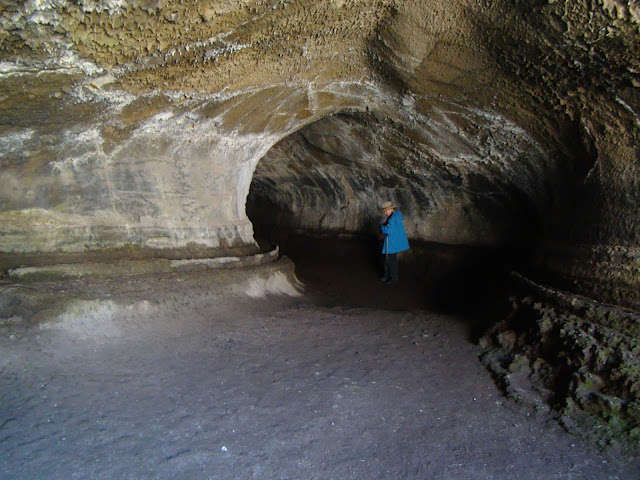
Lava Tube in Lava Beds National Monument
What will you see and experience? On the 17th we'll leave MJC and drive north through the Great Valley of California and arrive at the south end of the Cascades Range. The huge edifice of Mt. Shasta looms over the north state at 14,163 feet, and still is potentially active. It last erupted in 1786. Depending on snow conditions, we'll climb to the 8,000 feet level at the old ski bowl and have a close look at the rock and ash deposits. We'll continue north and end the day at Lava Beds National Monument near the Oregon border. There will be chance to explore some lava tubes while we are there.
The view from Smith Rock State Park in Oregon
We drive through Oregon the next day, with possible stops at Crater Lake National Park and Newberry Crater (depending, once again, on snow conditions). Camp will be at Tumalo State Park. The following day we will explore Smith Rock State Park (above), Mt. Hood, and the Columbia River Gorge (if there is time we will climb Beacon Rock in the gorge). The third camp will be at Seaquest State Park at the foot of Mt. St. Helens in southern Washington.
Mt. St. Helens in Washington. It erupted in 1980 and 2004
The following day will be devoted to the exploration of Mt. St. Helens (weather allowing!). We'll then descend the eastern flank of the Cascades (including a close look at Mt. Rainier) and drive onto the Columbia River Plateau, a vast basalt plain that covers much of eastern Washington and Oregon. Camp will be at Wanapum State Park on the Columbia River near Vantage.
Dry Falls State Park in Washington. The floodwaters covered this entire landscape to a depth of 300 feet during the Spokane floods.
The next day we will view the evidence for vast floods that swept across the plateau during the Pleistocene ice ages. The discovery of these floods by J Harlan Bretz in the 1920s and the long road to acceptance of the hypothesis by the geological community is one of the great stories in the history of geology as a science. We'll have a look at the Channeled Scablands, Soap Lake, and Dry Falls as we travel east through Washington. We'll spend the night at Riverside State Park in Spokane, Washington.
Lake McDonald in Glacier National Park
We'll head through the copper mining districts of Idaho and into Montana where we'll see more evidence of the ice age floods, including the Camas Prairie where ripplemarks 30 feet high can be found. We'll end the day in a special place, Glacier National Park on the Montana-Canada border. We'll spend two days exploring the park, with chances at several hikes. The park is a showcase of glacial erosion, but the glaciers that exist in the park today are expected to be gone within a decade or two because of global warming.
Saint Mary Lake in Glacier National Park, Montana
When we leave Glacier, we'll head south through the high plains on the east side of the Rocky Mountains and end the day at the KOA in Bozeman, Montana. We'll check out the Museum of the Rockies, and depending on snow conditions, explore some of the high mountains that surround Yellowstone, and eventually drive the Beartooth Highway into Yellowstone, America's oldest national park. We'll spend two days exploring this incredible park.
Yellowstone Falls in the Grand Canyon of the Yellowstone River
There is the Grand Canyon of Yellowstone, and a menagerie of incredible animals, including elk, bison, moose, bighorn sheep, and if we get really lucky, wolves.
Wolf near Norris Geyser Basin, Yellowstone National Park
Then there are geothermal features for which Yellowstone is so famous. Grand Prismatic Spring, for instance, and 70% of the world's geysers (there's lots more besides just Old Faithful!).
Grand Prismatic Spring, Yellowstone National Park
We'll then head south and spend two days at Grand Tetons National Park with time for some spectacular hikes. Then we start the road home with a drive through northern Nevada to Berlin/Ichthyosaur State Park to see the fossilized remains of the behemoth swimming reptiles from the age of the dinosaurs. Finally, we expect to see Mono Lake and the high country of Yosemite National Park. If snow blocks our path, we head home over Sonora or Carson passes.
Big Geyser (not Old Faithful!) in Lower Basin, Yellowstone National Park

It's hard to describe the wonders that exist across the Pacific Northwest and Northern Rocky Mountains without getting an overwhelming urge to get up and leave right away. If you are interested in joining us this summer, please check out the course web page at http://hayesg.faculty.mjc.edu/GeologyPacificNorthwest.html and join our Facebook page at https://www.facebook.com/groups/185168445318910/. If you are in the Modesto region, we are having an information meeting on Monday, April 10 in the Science Community Center on the west campus of the Modesto Junior College at 7 PM in SCC 326 (attendance is not mandatory to go on the trip). We hope you will join us!