Showing posts with label Montana. Show all posts

Monday, April 3, 2017

Explore the Pacific Northwest and Northern Rocky Mountains with Geotripper! June 17-July 1, 2017

Grand Tetons National Park, Wyoming
Be forewarned. This post is a TRAP! It is designed to draw you in, weaken your defenses, and cause you to do something different than everyday life. Warning given...

Have you ever dreamed of hitting the open road and finally seeing those places you've dreamed about, but haven't acted on that dream yet? What if you found out about an excursion that doesn't just tour, but allows you to learn the geology and history of those wild places? A tour on which you can even earn college credit? AND, a tour that is affordable? Maybe this is the one...
Mt. Shasta, a Cascade volcano in northern California
From June 17-July 1, 2017, the geology department of Modesto Junior College will be conducting a field studies course (Geology 192) in the Pacific Northwest and Northern Rocky Mountains. It will be a three semester unit course designed for our community college clientele: first year geology majors, potential geology majors, and community members (especially teachers) interested in geology and natural history. We will develop the necessary geological background prior to and in the early days of the trip, so people of all backgrounds are encouraged to attend. The total cost is $800 which will include all food, camp fees, entrance fees, transportation costs for the trip. The tuition cost for the three units of semester credit will be around $180 (out of state tuition is higher, around $200 a unit, which is still a deal). The only additional costs should be for showers, laundry, books and other souvenirs, and junk food (we provide healthy food for the most part; if you want Twinkies you are on your own!). We will be camping each night, and the school provides the transportation (vans). The excellent meals are planned by our professional volunteer staff, and cooked by the participants under their watchful eyes.
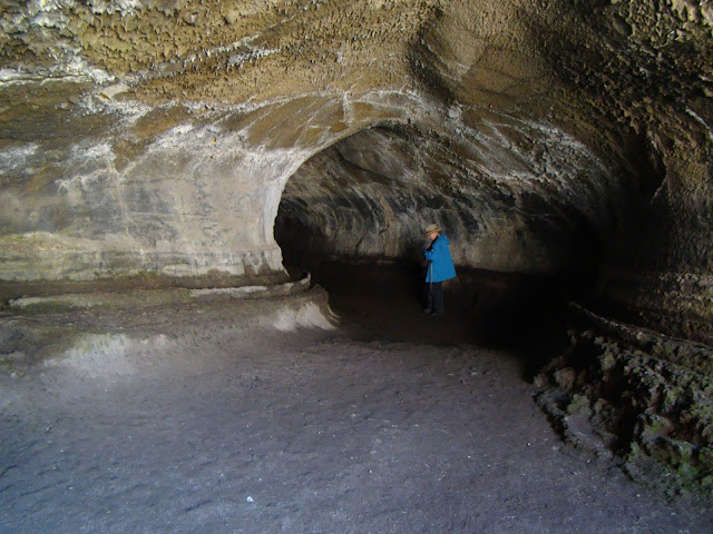
Lava Tube in Lava Beds National Monument
What will you see and experience? On the 17th we'll leave MJC and drive north through the Great Valley of California and arrive at the south end of the Cascades Range. The huge edifice of Mt. Shasta looms over the north state at 14,163 feet, and still is potentially active. It last erupted in 1786. Depending on snow conditions, we'll climb to the 8,000 feet level at the old ski bowl and have a close look at the rock and ash deposits. We'll continue north and end the day at Lava Beds National Monument near the Oregon border. There will be chance to explore some lava tubes while we are there.
The view from Smith Rock State Park in Oregon
We drive through Oregon the next day, with possible stops at Crater Lake National Park and Newberry Crater (depending, once again, on snow conditions). Camp will be at Tumalo State Park. The following day we will explore Smith Rock State Park (above), Mt. Hood, and the Columbia River Gorge (if there is time we will climb Beacon Rock in the gorge). The third camp will be at Seaquest State Park at the foot of Mt. St. Helens in southern Washington.
Mt. St. Helens in Washington. It erupted in 1980 and 2004
The following day will be devoted to the exploration of Mt. St. Helens (weather allowing!). We'll then descend the eastern flank of the Cascades (including a close look at Mt. Rainier) and drive onto the Columbia River Plateau, a vast basalt plain that covers much of eastern Washington and Oregon. Camp will be at Wanapum State Park on the Columbia River near Vantage.
Dry Falls State Park in Washington. The floodwaters covered this entire landscape to a depth of 300 feet during the Spokane floods.
The next day we will view the evidence for vast floods that swept across the plateau during the Pleistocene ice ages. The discovery of these floods by J Harlan Bretz in the 1920s and the long road to acceptance of the hypothesis by the geological community is one of the great stories in the history of geology as a science. We'll have a look at the Channeled Scablands, Soap Lake, and Dry Falls as we travel east through Washington. We'll spend the night at Riverside State Park in Spokane, Washington.
Lake McDonald in Glacier National Park
We'll head through the copper mining districts of Idaho and into Montana where we'll see more evidence of the ice age floods, including the Camas Prairie where ripplemarks 30 feet high can be found. We'll end the day in a special place, Glacier National Park on the Montana-Canada border. We'll spend two days exploring the park, with chances at several hikes. The park is a showcase of glacial erosion, but the glaciers that exist in the park today are expected to be gone within a decade or two because of global warming.
Saint Mary Lake in Glacier National Park, Montana
When we leave Glacier, we'll head south through the high plains on the east side of the Rocky Mountains and end the day at the KOA in Bozeman, Montana. We'll check out the Museum of the Rockies, and depending on snow conditions, explore some of the high mountains that surround Yellowstone, and eventually drive the Beartooth Highway into Yellowstone, America's oldest national park. We'll spend two days exploring this incredible park.
Yellowstone Falls in the Grand Canyon of the Yellowstone River
There is the Grand Canyon of Yellowstone, and a menagerie of incredible animals, including elk, bison, moose, bighorn sheep, and if we get really lucky, wolves.
Wolf near Norris Geyser Basin, Yellowstone National Park
Then there are geothermal features for which Yellowstone is so famous. Grand Prismatic Spring, for instance, and 70% of the world's geysers (there's lots more besides just Old Faithful!).
Grand Prismatic Spring, Yellowstone National Park
We'll then head south and spend two days at Grand Tetons National Park with time for some spectacular hikes. Then we start the road home with a drive through northern Nevada to Berlin/Ichthyosaur State Park to see the fossilized remains of the behemoth swimming reptiles from the age of the dinosaurs. Finally, we expect to see Mono Lake and the high country of Yosemite National Park. If snow blocks our path, we head home over Sonora or Carson passes.
Big Geyser (not Old Faithful!) in Lower Basin, Yellowstone National Park

It's hard to describe the wonders that exist across the Pacific Northwest and Northern Rocky Mountains without getting an overwhelming urge to get up and leave right away. If you are interested in joining us this summer, please check out the course web page at http://hayesg.faculty.mjc.edu/GeologyPacificNorthwest.html and join our Facebook page at https://www.facebook.com/groups/185168445318910/. If you are in the Modesto region, we are having an information meeting on Monday, April 10 in the Science Community Center on the west campus of the Modesto Junior College at 7 PM in SCC 326 (attendance is not mandatory to go on the trip). We hope you will join us!

Wednesday, August 6, 2014

Northern Convergence: A Geological Journey Through Canada and the Pacific Northwest


Some of the world's most dramatic landscapes exist within the strip of the North American continent between the High Plains of Canada and Montana and the Pacific Coast. The geologists call it the Western Cordillera, part of the mountain system that extends from the tip of South America to Alaska.

This mountainous terrain exists in large part because of a subduction zone that is or was once active offshore in the Pacific Ocean. This convergent boundary provided the mostly compressional forces that lifted these mountains.

We've just completed a journey across this incredible landscape, with the first ever extended tour of Canada by our department. Our travels took us from the Olympic Peninsula of Washington State to Vancouver Island, on a ferry across the Strait of Georgia to the Coastal Belt mountains and then into the western interior. We passed through Yoho, Banff, and Jasper National Parks in the Rocky Mountains, and spent some time on the High Plains before heading back into the States at Glacier National Park.

The journey was a collaboration between the geology and anthropology programs at Modesto Junior College. We learned the geological history of the land as well as the human history. It is a tough landscape, but people have lived and thrived here for at least 12,000 years.
The land also preserves the story of the ice times. Canada and the northern tier of states were once covered by thousands of feet of glacial ice. The glaciers had a profound effect on the landscape, and many of them still persist in the high country.

The High Plains reveal many secrets of past life forms on Earth. We paid a visit to one of the finest paleontology museums anywhere, the Royal Tyrrell in Drumheller, Alberta.
On our way back through Montana and Washington, we observed the effects of one of the greatest flood events in world history, the Spokane Floods of 16,000-12,000 years ago.
Our journey ended at one of the most visible effects of convergence: active volcanism. We explored part of Mt. Rainier, one of the most spectacular volcanoes on the planet.
Our route took us through some fascinating geology, and this new blog series will share some of the incredible things we saw. Stay tuned!

Tuesday, December 16, 2008

The Cretaceous Parks of the Colorado Plateau: the story of a Dino-Dig


What was your favorite dinosaur when you were a kid growing up?

Before I distracted myself with a series of geo-memes, I was telling the story of my sole experience with a real dino-excavation, as part of my long-running "short" history of the Colorado Plateau. The first posts explained how we got invited to assist on the dig, and some of our adventures on the way to Montana. Today is an explanation of what we were looking for.

As far as I can tell, I am one of the old-timers of the geoblogosphere, so my childhood memories include T-Rex, stegosaurus, brontosaurus (yes, I know the name is wrong...), triceratops, and pteranodons (yes, I know the ptera-animals aren't dinosaurs, but I didn't know it at the time). As far as my five-year-old self was concerned, they all lived at the same time, fought with each other, were sluggish and cold-blooded, and died out because the superior mammals ate their eggs.

In the 1980's and 1990's, public perception of the dinosaurs was changing, due in part to the movie "Jurassic Park", but really because of the extensive work of numerous paleontologists, some of whom were talented at presenting their work to laypeople through such books as The Dinosaur Heresies (Robert Bakker), and Digging Dinosaurs (John Horner). A sort of dinosaur renaissance followed, and with a vast increase in research into the lives (and deaths) of the dinosaurs, the total number of dinosaur species was doubled.

One of the opening salvos in the new perception of the dinosaurs was a report by John Ostrom in 1969 about his discovery of deinonychus fossils in association with a tenontosaurus at a quarry near Bridger, Montana (the picture above is adapted from Ostrom's report; it was drawn by Robert Bakker, who was his research assistant for years). The velociraptors, popularized (and vastly enlarged) in the movie Jurassic Park, were actually no bigger than a german shepherd. The closely-related Deinonychus would have been a bit closer to the size of the creatures in the movie, although Utahraptor would have been even closer. At Ostrom's quarry, at least four individual raptors died along with the large plant-eating tenontosaur, leading to speculation that the predators had attacked the much larger creature together (and had died in the process). The result of Ostrom's analysis was that at least some of the dinosaurs were closely related to the birds, that they were agile and warm-blooded, and that some may have cooperated in bringing down prey. These were revolutionary and controversial ideas at the time.

So, what were we up to in 1994? We were going to help reopen John Ostrom's quarry! The distinctive hill is called the Shrine site (although we were also told it was named for a particular part of the original ranch owner's wife's anatomy), and is located in the badlands near Bridger, Montana. It is an exposure of the Cretaceous Cloverly Formation, which is related to the Cedar Mountain Formation on the Colorado Plateau, and is composed of sand and silt deposited on a muddy river floodplain. The idea of pack behaviour among dinosaurs remains a controversial subject, and by digging further into the side of the hill, we hoped to find more evidence concerning these predators of the early Cretaceous.

We couldn't have asked for a more dramatic setting. Besides the vivid colors of the nearby badlands, we had a skyline view of the high Beartooth Mountains that form the eastern edge of Yellowstone National Park. To the east rose the Pryor Mountains, and a few miles beyond, the Bighorn River (yeah, the Custer's Last Stand one). The picture of the camp above hardly does it justice (all that pre-digital photography with cheap cameras).

We met the professional crew, Geoff and Desmond, and a couple of amateur dino-diggers from the Bay Area, and starting looking over the quarry site. We knew our role; it was to remove the side of the mountain so the bone people could get to the bone layer with their brushes and dental picks. As Arlo Guthrie put it, we came armed with shovels and picks and implements of destruction. We set up camp, and made dinner. Work would commence the next morning....

Ostrom, J. H. (1969). "Osteology of Deinonychus antirrhopus, an unusual theropod from the Lower Cretaceous of Montana". Peabody Museum of Natural History Bulletin 30: 1–165.

Thursday, December 4, 2008

The Cretaceous Parks of the Colorado Plateau: Every Cloud has a Golden Lining


Following up on today's earlier post, we picked up the debris of our devastated campsite at Grand Tetons, and headed a few miles north to Yellowstone National Park. As if to make up for our rude reception the previous night, the rain gods gave us a tremendously beautiful sunset, and the geothermal gods provided an eruption of Old Faithful at the precise moment the sun hit the horizon. It felt magical.


The next morning, following what must have been the shortest, quickest field trip through Yellowstone National Park in geological field trip history, we made our way north to Bozeman, Montana, and visited the Museum of the Rockies, which has some of the finer dinosaur exhibits to be seen anywhere. I'm not sure if it helped our expectations to see the full mounted specimen of a deinonychus although it did give us an idea of what pieces we would be looking for at the quarry site. The early scenes of dinosaur digging in the movie Jurassic Park may have shaded our expectations a little bit, too. Intellectually, we knew that full complete articulated skeletons of dinos are very rarely ever found. Still, we were going to be digging in a place where relatively complete skeletons had been found in the past (more on this in future posts).


Somehow, distances on the maps of Montana don't quite add up to the distances on the actual roads in Montana, and we pulled into the Montana metropolis of Bridger (population 700) about four hours late to meet the quarry director (aren't first impressions the greatest thing?), and then followed the "road" for seven or eight miles to the quarry site. I use the term "road" only in the sense that the sagebrush was beaten down in such a way that an excellent tracker would be able to discern that a vehicle may have passed this way at some indeterminate time in the past. We crossed a creek, and floored the accelerator to make it up the other side, and pulled into camp....


More tomorrow!

The Cretaceous Parks of the Colorado Plateau: the Story of a DinoDig


To continue our story of the Cretaceous history of the Colorado Plateau, we have taken a slight detour to the north to Montana, where the Cloverly Formation stands in for the Cedar Mountain Formation as the critical link between the late Jurassic ecosystems of the Morrison Formation and the later more widespread late Cretaceous formations. As explained in a previous post, this is because I've dug in the Cloverly, but have never seen (or at least recognized) the Cedar Mountain Formation to the south.

Lots of people participate in dinosaur digs, either as researchers, as students, or as paying volunteers through any number of commercial excavators. Our opportunity arose in 1993 when Jack Horner gave a lecture at Modesto Junior College on Tyrannosaurus rex (thus, the photo above). You may recall that at the time the movie Jurassic Park had pretty much re-ignited dinosaur-mania around the country, and Horner had gained some notoriety as a technical advisor for the film-makers. He had also garnered popular attention as the author of several great books about parenting dinosaurs (the Maiasaurs), and T-Rex (horrible predator or scavenger?). So his arrival at MJC caused quite a stir among my geology students, and they (and me too, I guess) hung around him like a bunch of groupies.

Over beer and pizza the next day, Mr. Horner suggested that we could help with one of his digs that coming summer in Montana, if we were at all interested. He stipulated that we could include 7-8 students, we would have to feed ourselves, provide all our camping supplies, get to Montana at our own expense, and that we would be diggers, not brushers and excavators. It would be hot and dusty or rainy and windy, or even snowy. There would be cows. Starstruck, we said yes, sounds fun!

Over the following months, the list of students crept up to 17 (lots of delicate e-mail negotiations), and they worked hard raising funds with burger sales and yard sales. Eventually they raised something like $5,000 to fund our expedition. So, early in June we set forth in our vans on the way to Bridger, Montana. The first day we slogged our way 550 miles to Angel Lake in the Humboldt Range of Nevada, and the next day traveled to Grand Tetons National Park, where we set up camp in the Gros Ventre Group Campground.

What happened that particular evening became one of our department legends for the ages. One our students had a knack for fomenting trouble with the powers-that-be in the Universe. On various previous trips he had speculated about what it would be like to get stung by a scorpion, and within a day, he had been (unwillingly) stung by a scorpion. At a stop, he asked if we would see any rattlesnakes. He stepped on one moments later. There was a karma that hung about Craig like a hangman's noose.


There was a discussion that evening at Grand Tetons in the twilight about whether we would experience any bad weather on our journey. The skies were clear that night with just a few puffy clouds about. For some reason, Craig looked at towards the heavens, raised a rock hammer towards the sky, and said "I dare the gods to make it rain!". I'm not kidding about what followed. Within ten minutes of his brash statement, our campground was enveloped in a violent storm, our vision obscured by thick blowing dust, and high winds were knocking down old cottonwood trees all around us. Fifteen minutes later the winds died, the dust cleared, and the camp was a shambles. Tents were ripped apart, and branches were down all over our camp. Our vans were undamaged, but a tree had crushed a van in the other part of the campground (people were in it, but were unhurt). We thought we had been hit by a tornado, but more likely it was a microburst from a storm that approached us unseen from the east.


Needless to say, Craig spent much of the rest of the trip muzzled....and this story will be continued.