 |
| Grand Tetons National Park, Wyoming |
Be forewarned. This post is a TRAP! It is designed to draw you in, weaken your defenses, and cause you to do something different than everyday life. Warning given...
Have you ever dreamed of hitting the open road and finally seeing those places you've dreamed about, but haven't acted on that dream yet? What if you found out about an excursion that doesn't just tour, but allows you to learn the geology and history of those wild places? A tour on which you can even earn college credit? AND, a tour that is affordable? Maybe this is the one...
 |
| Mt. Shasta, a Cascade volcano in northern California |
From June 17-July 1, 2017, the geology department of Modesto Junior College will be conducting a field studies course (Geology 192) in the Pacific Northwest and Northern Rocky Mountains. It will be a three semester unit course designed for our community college clientele: first year geology majors, potential geology majors, and community members (especially teachers) interested in geology and natural history. We will develop the necessary geological background prior to and in the early days of the trip, so people of all backgrounds are encouraged to attend. The total cost is $800 which will include all food, camp fees, entrance fees, transportation costs for the trip. The tuition cost for the three units of semester credit will be around $180 (out of state tuition is higher, around $200 a unit, which is still a deal). The only additional costs should be for showers, laundry, books and other souvenirs, and junk food (we provide healthy food for the most part; if you want Twinkies you are on your own!). We will be camping each night, and the school provides the transportation (vans). The excellent meals are planned by our professional volunteer staff, and cooked by the participants under their watchful eyes.
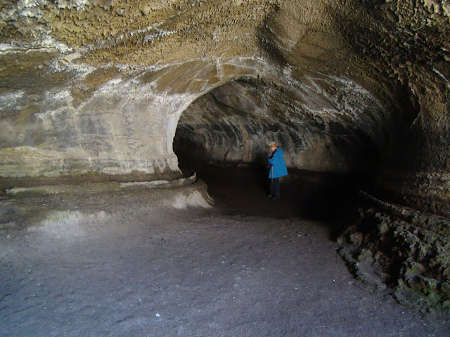 |
| Lava Tube in Lava Beds National Monument |
What will you see and experience? On the 17th we'll leave MJC and drive north through the Great Valley of California and arrive at the south end of the Cascades Range. The huge edifice of Mt. Shasta looms over the north state at 14,163 feet, and still is potentially active. It last erupted in 1786. Depending on snow conditions, we'll climb to the 8,000 feet level at the old ski bowl and have a close look at the rock and ash deposits. We'll continue north and end the day at Lava Beds National Monument near the Oregon border. There will be chance to explore some lava tubes while we are there.
 |
| The view from Smith Rock State Park in Oregon |
We drive through Oregon the next day, with possible stops at Crater Lake National Park and Newberry Crater (depending, once again, on snow conditions). Camp will be at Tumalo State Park. The following day we will explore Smith Rock State Park (above), Mt. Hood, and the Columbia River Gorge (if there is time we will climb Beacon Rock in the gorge). The third camp will be at Seaquest State Park at the foot of Mt. St. Helens in southern Washington.
 |
| Mt. St. Helens in Washington. It erupted in 1980 and 2004 |
The following day will be devoted to the exploration of Mt. St. Helens (weather allowing!). We'll then descend the eastern flank of the Cascades (including a close look at Mt. Rainier) and drive onto the Columbia River Plateau, a vast basalt plain that covers much of eastern Washington and Oregon. Camp will be at Wanapum State Park on the Columbia River near Vantage.
 |
| Dry Falls State Park in Washington. The floodwaters covered this entire landscape to a depth of 300 feet during the Spokane floods. |
The next day we will view the evidence for vast floods that swept across the plateau during the Pleistocene ice ages. The discovery of these floods by J Harlan Bretz in the 1920s and the long road to acceptance of the hypothesis by the geological community is one of the great stories in the history of geology as a science. We'll have a look at the Channeled Scablands, Soap Lake, and Dry Falls as we travel east through Washington. We'll spend the night at Riverside State Park in Spokane, Washington.
 |
| Lake McDonald in Glacier National Park |
We'll head through the copper mining districts of Idaho and into Montana where we'll see more evidence of the ice age floods, including the Camas Prairie where ripplemarks 30 feet high can be found. We'll end the day in a special place, Glacier National Park on the Montana-Canada border. We'll spend two days exploring the park, with chances at several hikes. The park is a showcase of glacial erosion, but the glaciers that exist in the park today are expected to be gone within a decade or two because of global warming.
 |
| Saint Mary Lake in Glacier National Park, Montana |
When we leave Glacier, we'll head south through the high plains on the east side of the Rocky Mountains and end the day at the KOA in Bozeman, Montana. We'll check out the Museum of the Rockies, and depending on snow conditions, explore some of the high mountains that surround Yellowstone, and eventually drive the Beartooth Highway into Yellowstone, America's oldest national park. We'll spend two days exploring this incredible park.
 |
| Yellowstone Falls in the Grand Canyon of the Yellowstone River |
There is the Grand Canyon of Yellowstone, and a menagerie of incredible animals, including elk, bison, moose, bighorn sheep, and if we get
really lucky, wolves.
 |
| Wolf near Norris Geyser Basin, Yellowstone National Park |
Then there are geothermal features for which Yellowstone is so famous. Grand Prismatic Spring, for instance, and 70% of the world's geysers (there's lots more besides just Old Faithful!).
 |
| Grand Prismatic Spring, Yellowstone National Park |
We'll then head south and spend two days at Grand Tetons National Park with time for some spectacular hikes. Then we start the road home with a drive through northern Nevada to Berlin/Ichthyosaur State Park to see the fossilized remains of the behemoth swimming reptiles from the age of the dinosaurs. Finally, we expect to see Mono Lake and the high country of Yosemite National Park. If snow blocks our path, we head home over Sonora or Carson passes.
 |
| Big Geyser (not Old Faithful!) in Lower Basin, Yellowstone National Park |
It's hard to describe the wonders that exist across the Pacific Northwest and Northern Rocky Mountains without getting an overwhelming urge to get up and leave right away. If you are interested in joining us this summer, please check out the course web page at
http://hayesg.faculty.mjc.edu/GeologyPacificNorthwest.html and join our Facebook page at
https://www.facebook.com/groups/185168445318910/. If you are in the Modesto region, we are having an information meeting on Monday, April 10 in the Science Community Center on the west campus of the Modesto Junior College at 7 PM in SCC 326 (attendance is not mandatory to go on the trip). We hope you will join us!


