Showing posts with label Glacier National Park. Show all posts

Monday, April 3, 2017

Explore the Pacific Northwest and Northern Rocky Mountains with Geotripper! June 17-July 1, 2017

Grand Tetons National Park, Wyoming
Be forewarned. This post is a TRAP! It is designed to draw you in, weaken your defenses, and cause you to do something different than everyday life. Warning given...

Have you ever dreamed of hitting the open road and finally seeing those places you've dreamed about, but haven't acted on that dream yet? What if you found out about an excursion that doesn't just tour, but allows you to learn the geology and history of those wild places? A tour on which you can even earn college credit? AND, a tour that is affordable? Maybe this is the one...
Mt. Shasta, a Cascade volcano in northern California
From June 17-July 1, 2017, the geology department of Modesto Junior College will be conducting a field studies course (Geology 192) in the Pacific Northwest and Northern Rocky Mountains. It will be a three semester unit course designed for our community college clientele: first year geology majors, potential geology majors, and community members (especially teachers) interested in geology and natural history. We will develop the necessary geological background prior to and in the early days of the trip, so people of all backgrounds are encouraged to attend. The total cost is $800 which will include all food, camp fees, entrance fees, transportation costs for the trip. The tuition cost for the three units of semester credit will be around $180 (out of state tuition is higher, around $200 a unit, which is still a deal). The only additional costs should be for showers, laundry, books and other souvenirs, and junk food (we provide healthy food for the most part; if you want Twinkies you are on your own!). We will be camping each night, and the school provides the transportation (vans). The excellent meals are planned by our professional volunteer staff, and cooked by the participants under their watchful eyes.
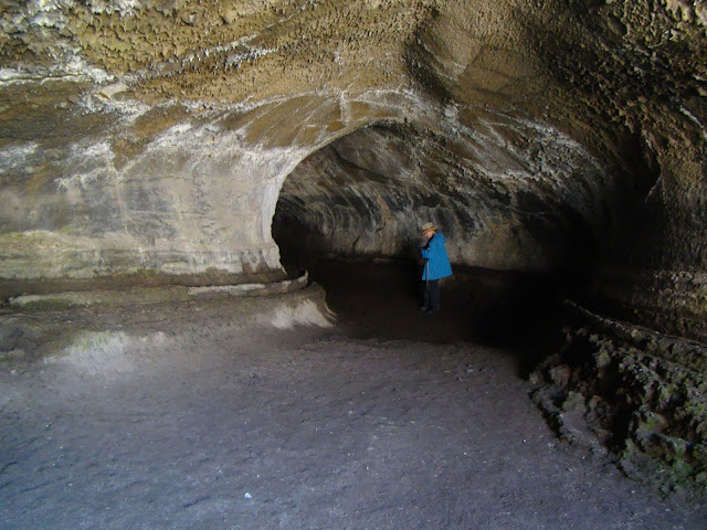
Lava Tube in Lava Beds National Monument
What will you see and experience? On the 17th we'll leave MJC and drive north through the Great Valley of California and arrive at the south end of the Cascades Range. The huge edifice of Mt. Shasta looms over the north state at 14,163 feet, and still is potentially active. It last erupted in 1786. Depending on snow conditions, we'll climb to the 8,000 feet level at the old ski bowl and have a close look at the rock and ash deposits. We'll continue north and end the day at Lava Beds National Monument near the Oregon border. There will be chance to explore some lava tubes while we are there.
The view from Smith Rock State Park in Oregon
We drive through Oregon the next day, with possible stops at Crater Lake National Park and Newberry Crater (depending, once again, on snow conditions). Camp will be at Tumalo State Park. The following day we will explore Smith Rock State Park (above), Mt. Hood, and the Columbia River Gorge (if there is time we will climb Beacon Rock in the gorge). The third camp will be at Seaquest State Park at the foot of Mt. St. Helens in southern Washington.
Mt. St. Helens in Washington. It erupted in 1980 and 2004
The following day will be devoted to the exploration of Mt. St. Helens (weather allowing!). We'll then descend the eastern flank of the Cascades (including a close look at Mt. Rainier) and drive onto the Columbia River Plateau, a vast basalt plain that covers much of eastern Washington and Oregon. Camp will be at Wanapum State Park on the Columbia River near Vantage.
Dry Falls State Park in Washington. The floodwaters covered this entire landscape to a depth of 300 feet during the Spokane floods.
The next day we will view the evidence for vast floods that swept across the plateau during the Pleistocene ice ages. The discovery of these floods by J Harlan Bretz in the 1920s and the long road to acceptance of the hypothesis by the geological community is one of the great stories in the history of geology as a science. We'll have a look at the Channeled Scablands, Soap Lake, and Dry Falls as we travel east through Washington. We'll spend the night at Riverside State Park in Spokane, Washington.
Lake McDonald in Glacier National Park
We'll head through the copper mining districts of Idaho and into Montana where we'll see more evidence of the ice age floods, including the Camas Prairie where ripplemarks 30 feet high can be found. We'll end the day in a special place, Glacier National Park on the Montana-Canada border. We'll spend two days exploring the park, with chances at several hikes. The park is a showcase of glacial erosion, but the glaciers that exist in the park today are expected to be gone within a decade or two because of global warming.
Saint Mary Lake in Glacier National Park, Montana
When we leave Glacier, we'll head south through the high plains on the east side of the Rocky Mountains and end the day at the KOA in Bozeman, Montana. We'll check out the Museum of the Rockies, and depending on snow conditions, explore some of the high mountains that surround Yellowstone, and eventually drive the Beartooth Highway into Yellowstone, America's oldest national park. We'll spend two days exploring this incredible park.
Yellowstone Falls in the Grand Canyon of the Yellowstone River
There is the Grand Canyon of Yellowstone, and a menagerie of incredible animals, including elk, bison, moose, bighorn sheep, and if we get really lucky, wolves.
Wolf near Norris Geyser Basin, Yellowstone National Park
Then there are geothermal features for which Yellowstone is so famous. Grand Prismatic Spring, for instance, and 70% of the world's geysers (there's lots more besides just Old Faithful!).
Grand Prismatic Spring, Yellowstone National Park
We'll then head south and spend two days at Grand Tetons National Park with time for some spectacular hikes. Then we start the road home with a drive through northern Nevada to Berlin/Ichthyosaur State Park to see the fossilized remains of the behemoth swimming reptiles from the age of the dinosaurs. Finally, we expect to see Mono Lake and the high country of Yosemite National Park. If snow blocks our path, we head home over Sonora or Carson passes.
Big Geyser (not Old Faithful!) in Lower Basin, Yellowstone National Park

It's hard to describe the wonders that exist across the Pacific Northwest and Northern Rocky Mountains without getting an overwhelming urge to get up and leave right away. If you are interested in joining us this summer, please check out the course web page at http://hayesg.faculty.mjc.edu/GeologyPacificNorthwest.html and join our Facebook page at https://www.facebook.com/groups/185168445318910/. If you are in the Modesto region, we are having an information meeting on Monday, April 10 in the Science Community Center on the west campus of the Modesto Junior College at 7 PM in SCC 326 (attendance is not mandatory to go on the trip). We hope you will join us!

Friday, October 24, 2014

Saying Good-bye to the Glaciers of Glacier National Park


The view north from Logan Pass in Glacier National Park
Make no mistake about it. Glacier National Park is one of the most spectacular parks in the United States, and indeed is one of my favorite places on planet Earth. That said, it's losing something important, and the change is profound.
How many animals are in this picture?
When I was a child, I loved museums, but I knew there was a big difference between seeing a stuffed animal in a quiet exhibit hall versus seeing one in the wild. A living, breathing animal trumps a stuffed one every time, especially if said animal is capable of killing you!
I suppose Bighorns could kill you, but I was thinking more of bears...
And that's my problem with what's happening in Glacier National Park. It's hard to put a glacier in a museum. In 1850, there were around 150 glaciers within the park boundaries. Today there are only 25. And they will be gone soon, probably by 2030. The sights we've been enjoying over the years with our visits to Glacier are disappearing at a rate that is heart-breaking. Of all of the signs of climate change, the loss of glaciers is the most vivid. Glacier will always be a beautiful park, and I will keep going back for as long as I am able, but it will soon stand as a monument to glaciation rather than a place where one can experience glaciers. And that is a shame.
Clements Mountain near Logan Pass in Glacier National Park
The changes will go beyond just the loss of glacial ice and scenery. The balance of river flows will change, both in the patterns of volume, but also temperature. Some native species depend on the year-round cold flows that emanate from glaciers. Some streams without a glacier at the source will be drying up before the next winter comes around. Habitats of all animals will be driven to higher elevations, and those at the higher altitudes in the park may find themselves without any habitat at all. We are already seeing the kinds of devastation wrought by pine borer beetles in Colorado and Wyoming. Devastating wildfires have already affected large parts of the park. We are now living the predicted changes in our global climate.
Glacially carved valley east of Logan Pass
The primary purpose of our trip was an exploration of Canada, so our visit to Glacier National Park was a short one as we drove west. We usually stay two nights and spend some time on the trails. We traveled along the spectacular Going to the Sun Highway over Logan Pass, and spent several hours exploring the alpine meadows above the pass. 
Glacier Lilies at Logan Pass
As every climatologist will tell you, there is a big difference between climate and weather. Weather is the day-to-day conditions outside ("It's cold outside") whereas climate is the long-term patterns of temperature and precipitation. Climate changes slowly over time while weather happens daily. Yet it is hard not to notice the daily extremes. When we climbed out of our vehicles at Logan Pass (6,647 feet; 2026 meters) it was 86 degrees. We were surrounded by rapidly melting snowbanks, and it was uncomfortable 86 degrees. The herd of Bighorn Sheep noticed. Some of them were laying in the snow to keep cool.
The meadows above Logan Pass in Glacier National Park
The geologic story of Glacier National Park bears some resemblance to that of Banff and Yoho National Parks in Canada, but there are big differences as well. Like the Canadian Rockies, large blocks of sedimentary rocks have been thrust eastward over softer Cretaceous rocks of the High Plains. Unlike the Canadian parks, the rocks at Glacier are older, closer to a billion years of age (Banff and Yoho sediments are around 500 million years old). They are part of a sequence of rocks called the Belt Series. They contain fossils, but they are of algal deposits called stromatolites. Multicelled creatures did not yet exist.
The peaks were high enough to stand above the vast continental ice sheets that covered the adjacent plains. The glaciers plucked and abraded the flanks of the high peaks, leaving behind outstanding examples of horns, aretes, and cirques. But unfortunately, many of the banks of ice are no longer considered glaciers, as they have shrunk and stagnated. When the chunks of ice no longer move, they aren't glaciers anymore.
Horns and aretes north of Logan Pass
We headed down the incredible west side of the Going to the Sun Highway very slowly, both to avoid plummeting to our deaths down the steep cliffs, but also to avoid running into the beautiful Rocky Mountain Goats who were licking up salt off the roadway.
We reached beautiful Lake McDonald, had a last look at the high glaciated peaks, and then headed west to Kalispell to our hotel. We would be making our way to Washington the next day on our way home. The Northern Convergence tour was reaching the final stages, but there was still much to be seen on the road ahead!
Lake McDonald at the west end of the Going to the Sun Highway.


Wednesday, October 22, 2014

Northern Convergence: Leaving a Beautiful Country

How will we deal with the hordes of people from the U.S. trying to invade our borders?
Our trip, the Northern Convergence tour, was not over, but the time had come to cross the border back into the United States from Canada. The trip thus far had been an eye-opener. We had been exploring the "crowded" part of Canada in British Columbia and Alberta, but the land itself exuded wildness and isolation.
We were on the High Plains east of the Rocky Mountains, and had spent the morning at the Head Smashed In Buffalo Jump World Heritage Site, and as gruesome as the name was, it was a fascinating place. From there we headed south to the border crossing at Carway. We figured since it had a name that there would be a town and facilities. We got there, and there was...one building. It was a duty-free souvenir/liquor/tobacco shop, and thank goodness, it had a restroom. Still, there were some picnic tables so we stopped for lunch and had a look around. We also wondered if the authorities were going to let us back into the United States. You never know...in the innocent days before 9/11, we were interrogated about whether we had any "Beanie Babies" in our luggage. I laughed at the question, and the border agent got very serious: "Sir, DO YOU have any Beanie Babies?"
We were not exactly in the High Plains, as the land was broken up into swales and shallow valleys underlain by very soft Cretaceous shale deposits. The shales had been deformed and twisted by the same convergent forces that had lifted the nearby Rocky Mountains, but erosion had smoothed off the sharp edges. The land was semiarid and treeless. More verdant lands could be seen in the distance as we looked westward towards the Rocky Mountains and Waterton-Glacier International Peace Park. Glacier National Park was our next destination.
Chief Mountain was especially prominent on the western horizon. The peak is an outlier of the Rocky Mountains, an isolated upper plate of a thrust fault that had pushed the hard Paleozoic limestones over the softer Cretaceous rock. Erosion had then isolated Chief Mountain as a klippe (see the diagram below).

The mountain was a dramatic welcome back into the United States. We only had a few more days left on our journey, but there was still much to be seen. The story will continue in another post!
Source: http://en.wikipedia.org/wiki/Klippe

Thursday, July 31, 2014

That Such Places Exist Unsullied...I am Grateful


“After sleeping through a hundred million centuries we have finally opened our eyes on a sumptuous planet, sparkling with color, bountiful with life. Within decades we must close our eyes again. Isn’t it a noble, an enlightened way of spending our brief time in the sun, to work at understanding the universe and how we have come to wake up in it? This is how I answer when I am asked—as I am surprisingly often—why I bother to get up in the mornings.”

                                                                                                        Richard Dawkins

Geotripper is back! We are home from a glorious journey through British Columbia, Alberta, Montana and Washington. It was a stunning landscape with a fascinating geological story. A detailed series of posts of course will follow, but for today, I am sharing examples of some of the most beautiful landscapes in the world.
Indian Paintbrush in Yoho National Park

Emerald Lake, Yoho National Park

Takkakaw Falls, Yoho National Park

Mt. Rundle, Banff National Park

Bow Lake and Glacier, Banff National Park

Athabasca Glacier, Jasper National Park

Peyto Lake, Banff National Park

Drumheller Badlands in Dinosaur Country

Marmot at Head Smashed In Buffalo Jump Park in Alberta

Clements Mountain near Logan Pass in Glacier National Park

Bighorn Sheep at Logan Pass

Rocky Mountain Goats near Logan Pass

Mt. Adams from Sunrise Point, Mt. Rainier National Park

“Travel is like love, mostly because it’s a heightened state of awareness, in which we are mindful, receptive, undimmed by familiarity and ready to be transformed. That is why the best trips, like the best love affairs, never really end.” Pico Iyer

Tuesday, August 9, 2011

A Convergence of Wonders: A Compilation

The trip I called the Convergence of Wonders was a combined geology and archaeology course that we conducted on June 15-30, 2011, in which we explored the Pacific Northwest and Northern Rocky Mountains. Our students and volunteers traveled more than 4,500 miles through regions that have been influenced by convergence along the Cascadia and related subduction zones, as well as a hot spot and continental divergence. Each day revealed stunning geological features and insights into the human occupation of the region over the last 13,000 years or more. This is a compilation of all of the blog entries I posted about the trip.

"Journeys in the Pacific Northwest" was the introductory post about the series, and provided some background about why we did the trip we did, and what our goals were. 


"Journeys in the Pacific Northwest, Day 1" was the story of the trip from home to our first camp at Lava Beds National Monument on the night of the full moon. En route, we explored the flanks of Mt. Shasta, the largest stratovolcano in the Cascades, and found out that a record snowpack and late spring was going to be a problem on this trip.
"Day 2, Lava Beds and Newberry Caldera" includes our exploration of Lava Beds National Monument, including the extensive lava tube system, an incredible panel of petroglyphs, and the site of the last war between the federal government and Native Americans in California. Late in the day, we visited an obsidian dome in Newberry caldera.
"Day 3, Crossing the Subduction Zone" chronicled our passage across the Cascades to the Washington coast at the mouth of the Columbia River at Cape Disappointment State Park. Smith Rock State Park in Oregon was an incredibly scenic view into the heart of a rhyolite caldera eruption, and our day ended looking pillow basalts from the floor of the Pacific Ocean floor. In between, we checked out an excavation taking place at Fort Vancouver.
"Day 4: Cape Disappointment and Real Disappointments" was the story of weather-related disappointments. The skies opened up throughout the day, including along the flanks of Mt. St. Helens, which was to be the centerpiece of our exploration. The mountain remained invisible in the clouds. The sun emerged, of course, but not until we were far beyond the crest of the Cascades and almost to our camp in Yakima.
"Day 5: In the Land of the Great Flood" was a narrative of our passage across the wastelands produced by a series of catastrophic floods that defy human imagination. At Dry Falls, we looked at canyons (the coulees) that were carved in a few days or weeks of remarkable "river" flows hundreds of feet deep. We also had a chance to see the Wenas Creek Mammoth at Central Washington University.
"Day 6: In the Land of the Great Draining" was an exploration of the lands where the floodwaters originated: glacial Lake Missoula. We traversed a barren valley (the Camas Prairie) where ripplemarks thirty feet high convinced many geologists of the occurrence of the Spokane Floods. We arrived in beautiful Glacier National Park at the end of the day, and were greeted with an incredible rainbow.
"Day 7: Of Time and Pressure in Glacier National Park" found us at the Canadian border where we started an exploration of Glacier National Park, at least the parts that were not still snowbound. We checked out the Lewis Overthrust, and examined the Proterozoic sedimentary rocks that make up much of the park.
"Day 8: Of Time, Pressure, and the Plain Truth" found us out on the Great Plains east of Glacier. We toured the Museum of the Plains Indians in Browning, and worked our way past numerous thrust sheets in Sun Canyon, where convergence pushed numerous fault slices over one another. We also checked out some exhibits on some of the most famous discoveries concerning dinosaurs at Choteau, Montana.
"Day 9: Into the Depths of the Crust, and of Time" discusses one of the most spectacular roads in America, the Beartooth Highway from Red Lodge to Yellowstone National Park. We also checked out the Stillwater Mine, where platinum and other rare minerals are produced. The outcrops we were traversing including some of the most ancient rocks on the continent.
"Day 10: Explorations of a Real Hot Spot" was just that...a tour of Yellowstone National Park, one of the crown jewels of the National Park System. We explored Yellowstone Falls, the Grand Canyon of the Yellowstone, Mammoth Hot Springs, and Norris Geyser Basin. The highlight for many of us was the witnessing of a wolf competing with a raven at a kill site.
"Day 11: The Orange Steam is OK, but the Blue Stuff Will Kill You" was a further exploration of Yellowstone, with visits to Grand Prismatic Hot Spring, and the famous geysers in Upper Basin (yeah, Old Faithful was spouting off, but I was watching Beehive). We ended the day in Grand Teton National Park.
"Day 12: A Richness of Geological Drama at Grand Teton (and Pelicans)" was a beautiful day of exploration in the Grand Tetons. We also checked out the Gros Ventre Slide, one of the most famous slope failures in the United States.
"Day 13: Hidden Treasures and Hazards on the Road in Western Wyoming" saw us beginning the long journey home. We checked out the Game Creek Archaeological Site and Fossil Butte National Monument, and saw a lot of sagebrush as we made our way south into Utah...
"Day 14: Treasures Discovered and Lost in Nine Mile Canyon" chronicles an expedition through seventy-mile long Nine Mile Canyon, a showcase of Fremont Culture artwork and archaeological sites. The canyon is also a site of controversy, as heavy industry is mining natural gas in the area, with profound effects in the canyon itself. Later in the day, we saw the Dinosaur Museum in Price, and ended the day searching for Topaz crystals in the western Utah desert.
"Day 15: We Go Underground in Great Basin" saw us making a 500 mile journey across the Basin and Range Province, with a stop at Great Basin National Park for a tour of Lehman Cave, and a stop at Garnet Hill, for, eh, garnets. A motorcycle accident caused us to arrive in a spooky camp at 11:00 PM.
"Day 16: Our Home Mountains, Giant Swimming Reptiles, and a Bunny" was our last day on the road. We checked out the bizarre Mesozoic creatures at Berlin-Ichthyosaur State Park in Nevada, Mono Lake in eastern California, and Yosemite National Park in our backyard before arriving at the end our journey.