Showing posts with label granite dome. Show all posts

Thursday, August 27, 2015

Vagabonding on Dangerous Ground: Seeing Volcanoes from the Inside Out at Siám' Smánit (Stawamus Chief)

It's one thing to talk about a subduction zone from the outside, where one might see an oceanic trench, or a chain of volcanoes. It's quite another to explore the convergent zone from the inside out, by, for instance, standing under the volcano. Miles below the volcano. That's what one gets to do along the lower stretches of the Sea to Sky Highway between Whistler and Vancouver in British Columbia.

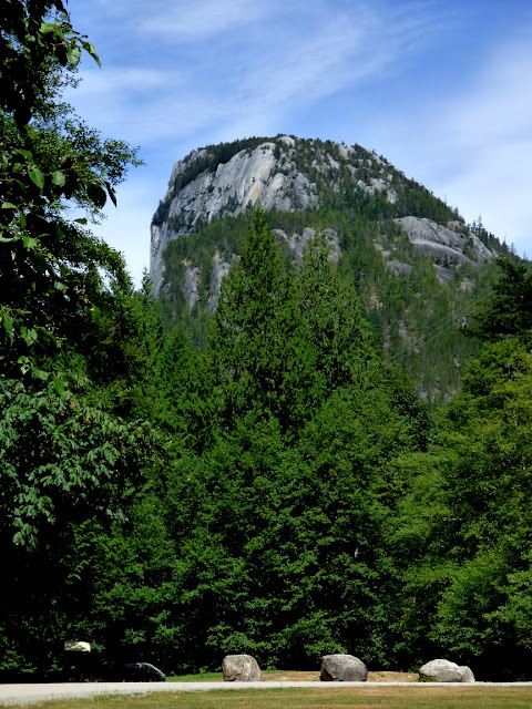
We were vagabonding our way through the landscapes of the Cascadia Subduction Zone between Northern California and the southern end of British Columbia. We were headed south towards home, but there were still some pretty intense sights ahead. As we drove down the Sea to Sky Highway back towards Vancouver, we had a chance to check out the awesome cliff of Siám' Smánit, Stawamus Chief at the head of Howe Sound. We got our first look of the immense cliff from several miles upstream at the Tantalus Overlook (below).
Stawamus Chief is a huge cliff and dome of granitic rock, specifically granodiorite (which chemically is a bit less rich in silica than actual granite). The chief has a height of 700 meters (2,297 feet), which is only a few hundred meters short of El Capitan in Yosemite National Park (900 meters, 3,000 feet). Interestingly, both names refer to "chiefs". The rock originated in magma chambers many kilometers below the surface of the Earth, underneath volcanoes that are presumed to have existed far above about 100 million years ago (the Cretaceous Period; dinosaurs would have wandered the slopes of these volcanoes). Tens of millions of years of erosion have removed the volcanoes and the many kilometers of intervening rock. We were quite literally standing within the internal plumbing of an ancient volcano!

One of the agents of erosion that has shaped Stawamus Chief was glaciation. We were at the head of Howe Sound, North America's southernmost glacial fjord, a spot where the ice stream was thousands of meters thick. The ice completely covered the "Chief" and eventually scoured and trimmed the edges of the huge rock.

In the 12,000 years or so since the ice melted back, the scoured and polished surfaces of the rock were weathered away, or buried beneath rock debris. Fresh looking glacial surfaces can be hard to find at times, but the 2010 Winter Olympics provided some excellent exposures here at Stawamus. How? The organizers widened the highway, and constructed a pedestrian bridge that provided access to the provincial park for people parking to the north.
The slopes in the Stawamus area were covered with glacial till and outwash deposits that hid the scoured granite surfaces. Engineers cut a low pass through the till. but they realized that the loose debris would be a road hazard. They carted away the till, exposing the beautifully carved and polished surfaces underneath.

Some of the till was still visible on the south side of the highway (below).

From north of the bridge, even more of the immense cliff could be seen. The mountain attracts legions of rock climbers, and we could see several of them inching their way up the rock face.

It was getting late, and the vagabonders had made no plans for the night. We continued down the highway, eventually finding accommodations in North Vancouver. The next day we would be making the border crossing back into the United States, where new adventures awaited. More to come!
Monday, September 8, 2014

Ongoing Exfoliation Event at Twain Harte Lake in the Sierra Nevada


There is an ongoing geological drama going on the Sierra Nevada that may be unique (to the extent of my knowledge, which is admittedly limited in this area). Exfoliation, a process long recognized as the shaper of granitic domes and monoliths, is presently busting up the surface of a small dome at Twain Harte Lake a few miles east of the Mother Lode town of Sonora. The process has been captured on video, and is presently being monitored, due to the effects it is having on a reservoir abutment.
The event burst into the news in August when a possible dam failure warning was issued following a loud popping sound and the leakage of water from the edge of the reservoir. Once the site was investigated, a decision was reached to drain the lake until the full extent of the damage was clear. There have been at least three 'events', the last on August 3.

An employee of the lake association was very kind and allowed me to have a look at the dome and the new exfoliation shells. It was fascinating. The first thing to catch the eye was the lifeguard tower. It's tilted at an odd angle because the rock it is sitting on has been pushed upward into what is called an "A-tent" joint. My erudite and learned comment was "wow"!
Exfoliation is the breaking and fracturing of hard rocks like granite in slabs parallel to the surface of the rock. It removes corners and edges, resulting in the familiar domes found in regions like the Sierra Nevada where lots of granitic rock is exposed. It has traditionally been described as the result of 'unloading', whereby erosion strips off the overlying rock, releasing pressure and causing the rock to expand outwards, and fracturing in the process. There are some alternate explanations involving a certain amount of compression, which makes sense looking at the 'A tent' in the picture above.

There were freshly loosened slabs all over the surface of the rock, with lots of chipped edges. From the videos it is clear that the chips often snapped loose before the major slab event, like foreshocks to an earthquake (and given that earthquakes are also an example of stress release, the analogy is appropriate).
How incredible it must have been to see this happen!
The worry, of course, is the proximity of the exfoliation slabs to the abutment of the dam. A geological consulting firm is monitoring the activity, with stress meters set up in several places.
I admit I never gave it any thought, but it seems clear that the fractures are occurring in a swarm, as the stress regime changes with each break, placing new pressures in different sectors. Like a series of aftershocks following an earthquake, the rocks will continue to shatter for a period of time until a new stable regime or equilibrium is reached. I don't know any details of how or if this process has been witnessed in the past, so I couldn't even speculate on how long these rock 'pops' will continue. Maybe they are already done, but I wouldn't count on it.
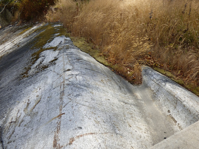
The picture below shows a series of fresh parallel fractures running perpendicular to the edge of the dam.
We took a closer look at the dam abutment. So far the damage is limited to the top few feet of the south margin of the dam.
In the picture below we are looking down on the edge of the dam and on the left one can see the fresh exfoliation fracture. It leads into the dam abutment.
In this next picture, we are looking closer at the edge of the dam and can see a crack running through the concrete, going down about three feet or so. The dam is around 70 years old, and had been inspected only a few months prior with no signs of problems.
No one can say that the episode is over with, but it was fascinating to see. As I said before, I'm not aware of whether this process has been monitored in real time before, and I can't find any examples of exfoliation being captured in action on film or video, although it most assuredly is happening all the time somewhere in the world. If I hear of any developments, I will pass them on.
Picture by Mrs.Geotripper
I certainly hope the good people of Twain Harte get their lake back. It looked pretty sad without any water. It is a popular swimming and fishing hole.

If you haven't seen the video, there are some very good ones on the web, courtesy of Condor Earth Technologies (click here for the link) and Dotysan, who is a local resident. Check them out!