Showing posts with label exfoliation. Show all posts

Sunday, November 5, 2017

Looking Down on Yosemite: A Return to Taft Point

I don't know how it happened, but somehow 12 years slipped by since I last made the hike out to Taft Point above the floor of Yosemite Valley. It's not that tough of a hike, only 1.1 miles with just a bit of climbing on the way back. But what a payoff at the end. There is nothing quite like standing on the brink of the ultimate abyss.
The trail begins at a parking lot about two miles up the road from Glacier Point. Parking is limited and fills quickly, so be sure to arrive early in the day, or you'll be walking a lot farther from your parking spot. Or you can do what I did and wait until about the last day of the season before a major snowstorm, and come at the end of the day when the sun is quickly sinking below the horizon.

The beginning of the trail in the deep Red Fir forest gives few hints of the grandeur that lies beyond. It almost immediately passes an unusual outcrop of almost pure quartz (remember y'all, it's a national park; no collecting!). The trail plunges into the forest and crosses Sentinel Creek, which a short distance downstream falls over the brink of Sentinel Falls, more than 1,000 feet high.
The trail breaks into the open, and one can sense the edge of nothingness that lies beyond. And then there's a distraction! There are huge open cracks near the cliff edge that split the rock for hundreds of feet. These are called the Taft Fissures, and they are a bit of evidence for the geology that led to the formation Yosemite Valley itself. The fissures follow distinct cracks in the granitic rock that makes up the cliffs in this area.

One of the Taft Fissures. The "layers" are exfoliation fractures, a process related to jointing.
Granite forms miles below the surface as molten magma within the crust cools slowly, forming a coarsely crystalline rock. The rocks are under tremendous pressure from the overlying rock, but over time the rocks are uplifted and erosion strips away the "overburden". As the rocks approach the surface, they expand in volume, but being solid, they crack to form joints. On the scale of Yosemite Valley, the joints were points of weakness that could be exploited by flowing glaciers to carve and cut away at the cliffs. Many of the sheer cliffs of Yosemite are joint surfaces. Unfortunately, many rockfalls begin with joints that give way along the vertical cliffs.
At Taft Fissures, the joints allowed water and ice to get into the interior of the rocks, causing the minerals on the surface of the rock to crumble to quartz gravel and clay dust. As the cracks widened, boulders would occasionally fall in and become wedged inside, as seen in the picture above.
Just beyond the fissures, the world ends...the cliff edge is the beginning of a sheer 3,000 foot drop to the valley floor below. The perspective is both stunning and dizzying. It's hard to believe, but the viewpoint makes El Capitan look almost...small. It's scattered in with so many other steep cliffs.
The fast-setting sun illuminated the cliff of El Capitan and the scar of the September rockfall from the cliff at Horsetail Fall. The first view in the picture above is not actually Taft Point. The point is on the upper left. I would have to head up there to get the entire view.

There are four stunning viewpoints within a short walk of Glacier Point Road. Washburn Point, seen in the last post, emphasizes the wilderness lands upstream of Yosemite Valley (and a side view of Half Dome). Glacier Point provides a look straight down into the upper end of the valley, extending from Half Dome and Tenaya Creek Canyon to the area around Yosemite Falls. Sentinel Dome provides a 360 degree panorama of the entire region, but without the dizzying look straight down sheer cliffs. It is accessed from the same trailhead as Taft Point.


Taft Point picks up the view of the valley floor at Yosemite Falls and provides a panorama of the western parts of the Yosemite Valley, taking in the Three Brothers, El Capitan, and the Cathedral Rocks which soar above Bridalveil Falls (which are hidden on the far side). The sweeping view also takes in the western slope of the Sierra Nevada, leading down to the Mother Lode foothills and the Great Valley beyond.
Although the rockfall at Horsetail Falls in September has garnered all the news these last few weeks, the view from Taft Point takes in a perspective on the largest historic slide in the valley, which happened in 1987. An estimated 600,000 cubic meters of rock came down the cliff of Middle Brother (on the right side of the picture above). Luckily, no one was hurt as the Park Service had shut down the road when loud sounds of fracturing rock were reported coming from the cliffs above. The September rockfall, in contrast, was a bit over 10,000 cubic meters.

The cliff of El Capitan and the sheer cliffs of the Cathedral Rocks form a constriction in the western part of Yosemite Valley. Sometimes called the "Gateway", the rocks stand out because they are relatively unjointed, and thus were more resistant to the cutting and quarrying action of the glacial ice. The barrier even extends underground. Beneath the cliffs, the sediments are only about 300 feet deep. Farther up the valley, the sediments are around 2,000 feet deep. The glaciers at times had to flow up and over the sill of granite.
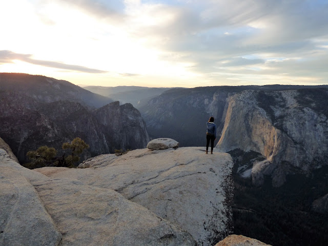
Taft Point is an amazing place. If you have a fear of heights, this will be a good place to either cure it forever, or amplify the condition to the point that you will be a whimpering mass of a nervous wreck. I don't mind looking over the edges of cliffs myself, although it will sometimes be on my belly. One never knows when one might have a fainting spell, after all. But I cannot watch others standing on cliff edges, especially if they are my students. I tell them to do their antics on their own time.

The sun hit the horizon and the sky exploded into flaming orange and pink. I quickly headed up the trail and back to the car so Mrs. Geotripper and I could have a nice dinner back down on the valley floor. It didn't matter that it was dark. The moon was up and we could still see the cliffs above, including a constellation of lights from at least fourteen climbing parties on El Capitan.

Sunday, October 25, 2015

A Series of Fortunate Events: Why Settle for Half a Dome When You Can Have a Whole One?


Imagine standing at one of the most famous park viewpoints in the world. Ask people standing in that place, the Wawona Tunnel Overlook at Yosemite National Park, how many granite domes they see, they might say just one. If they're feeling humorous, they might even say not just one, but half of one (let's discuss that point). But there are actually two of them. Sentinel Dome is the other somewhat less prominent dome, off to the right of Half Dome (see above).

The hike to the summit of Half Dome is the stuff of legend. One must start very early in the day, hike seven or so miles to the summit pitch (climbing 4,000 feet in the process), and then trudge up a terrifying set of cables and steps on an impossibly steep flank of the dome. People have even fallen off the trail to their deaths. I've not yet had the privilege (of hiking, not falling), but hope springs eternal!
Sentinel Dome is also climbable, but it is not nearly as taxing to the body and soul. It's only a few hundred feet shorter than Half Dome in elevation, but it is also close to the Glacier Point Road, so hiking to the summit is more of a short stroll than an all-day expedition. And it has a marvelous perspective on Yosemite Valley and the surrounding territory.

The official trail starts at the parking lot for Taft Point and Sentinel Dome trails. Get there early in the day because the parking lot fills quickly. These are popular trails. The hike to Sentinel is a mile, but if you are good with topographic maps, you can find an alternate route that is only half as long, and the parking area for the alternate way is almost always empty.

Which ever way you go, the trail passes through an open forest of Ponderosa and fir trees. As you near the ridge top, the sky opens wide and one can sense the huge chasm that lies beyond.

The summit area of Sentinel Dome is relatively barren of vegetation, and is instead an island of granitic rock rising out of the forest. The dome was not formed by the shaping effect of glaciation, and indeed glaciers never covered the summit. The rounding occurred because of exfoliation, the tendency of slabs of granite to break off of edges and corners. Walking the summit pitch one steps over the slabs like a stairway (below).
Exfoliation slabs on the summit pitch of Sentinel Dome

The exfoliation occurs because the granitic rock forms by the slow, slow cooling of silica-rich magma deep in the Earth's crust. The rock expands as it is exposed by erosion near the surface and fractures outward. The process still occurs in the region today. I've witnessed rockfalls from this very spot (see here for the story), and I posted last year about an exfoliation event in Twain Harte.

The view from the summit of Sentinel Dome is nothing short of spectacular. The Cathedral Rocks and El Capitan dominate the view west, while the Sierra Nevada foothills slope away in the distance towards the Great Valley.

East and south, the view takes in the high peaks of the Sierra Nevada Crest and the Clark Range.

Half Dome and Cloud's Rest dominate the scene to the east. Tenaya Canyon and Little Yosemite Valley lie in the shadows below. Yosemite Falls, had it been flowing, would have been visible to the north.

There used to be an iconic tree, a windblown Ponderosa Jeffrey Pine, at the summit. It appeared in many National Park Service photos. A vandal girdled the tree with a knife, killing it. Even here, people can be jerks and worse.

I took a 360 degree panorama with my video camera. It's linked below if you'd like to take a look!

We hiked back down to the cars and drove to the valley floor. The class was about the geology of Yosemite National Park, which encompasses over a thousand square miles. Yosemite Valley covers only about seven square miles, so we spent a surprisingly short period of time down there. We were headed for the high country, which we'll cover the in the next post!

Monday, September 8, 2014

Ongoing Exfoliation Event at Twain Harte Lake in the Sierra Nevada


There is an ongoing geological drama going on the Sierra Nevada that may be unique (to the extent of my knowledge, which is admittedly limited in this area). Exfoliation, a process long recognized as the shaper of granitic domes and monoliths, is presently busting up the surface of a small dome at Twain Harte Lake a few miles east of the Mother Lode town of Sonora. The process has been captured on video, and is presently being monitored, due to the effects it is having on a reservoir abutment.
The event burst into the news in August when a possible dam failure warning was issued following a loud popping sound and the leakage of water from the edge of the reservoir. Once the site was investigated, a decision was reached to drain the lake until the full extent of the damage was clear. There have been at least three 'events', the last on August 3.

An employee of the lake association was very kind and allowed me to have a look at the dome and the new exfoliation shells. It was fascinating. The first thing to catch the eye was the lifeguard tower. It's tilted at an odd angle because the rock it is sitting on has been pushed upward into what is called an "A-tent" joint. My erudite and learned comment was "wow"!
Exfoliation is the breaking and fracturing of hard rocks like granite in slabs parallel to the surface of the rock. It removes corners and edges, resulting in the familiar domes found in regions like the Sierra Nevada where lots of granitic rock is exposed. It has traditionally been described as the result of 'unloading', whereby erosion strips off the overlying rock, releasing pressure and causing the rock to expand outwards, and fracturing in the process. There are some alternate explanations involving a certain amount of compression, which makes sense looking at the 'A tent' in the picture above.

There were freshly loosened slabs all over the surface of the rock, with lots of chipped edges. From the videos it is clear that the chips often snapped loose before the major slab event, like foreshocks to an earthquake (and given that earthquakes are also an example of stress release, the analogy is appropriate).
How incredible it must have been to see this happen!
The worry, of course, is the proximity of the exfoliation slabs to the abutment of the dam. A geological consulting firm is monitoring the activity, with stress meters set up in several places.
I admit I never gave it any thought, but it seems clear that the fractures are occurring in a swarm, as the stress regime changes with each break, placing new pressures in different sectors. Like a series of aftershocks following an earthquake, the rocks will continue to shatter for a period of time until a new stable regime or equilibrium is reached. I don't know any details of how or if this process has been witnessed in the past, so I couldn't even speculate on how long these rock 'pops' will continue. Maybe they are already done, but I wouldn't count on it.
The picture below shows a series of fresh parallel fractures running perpendicular to the edge of the dam.
We took a closer look at the dam abutment. So far the damage is limited to the top few feet of the south margin of the dam.
In the picture below we are looking down on the edge of the dam and on the left one can see the fresh exfoliation fracture. It leads into the dam abutment.
In this next picture, we are looking closer at the edge of the dam and can see a crack running through the concrete, going down about three feet or so. The dam is around 70 years old, and had been inspected only a few months prior with no signs of problems.
No one can say that the episode is over with, but it was fascinating to see. As I said before, I'm not aware of whether this process has been monitored in real time before, and I can't find any examples of exfoliation being captured in action on film or video, although it most assuredly is happening all the time somewhere in the world. If I hear of any developments, I will pass them on.
Picture by Mrs.Geotripper
I certainly hope the good people of Twain Harte get their lake back. It looked pretty sad without any water. It is a popular swimming and fishing hole.

If you haven't seen the video, there are some very good ones on the web, courtesy of Condor Earth Technologies (click here for the link) and Dotysan, who is a local resident. Check them out!


Sunday, August 17, 2014

Exfoliation in action in Twain Harte


Okay, so this is different. I've never seen exfoliation actually happen. I've seen distant rockfalls that might have been initiated by exfoliation, but this is pretty wild. Twain Harte is the Sierra Nevada village where there were dam failure worries a few weeks ago, probably related to exfoliation. It was posted by Dotysan on YouTube. Good job!

Thursday, May 26, 2011

Water in a Dry Land: Joshua Tree National Park, and Getting Tanked


A lake in the desert? That can't be right...

Joshua Tree National Park has a bit of a schizophrenic aspect. Geologicially, the park is divided into vast tracts of metamorphic rock separated from large areas of granitic rock. Topographically, the park is divided into the higher Mojave Desert and the lower Colorado Desert (the High Desert and Low Desert of SoCal weather reports). The elevation and rock differences result in large contrasts in water availability, and thus vegetation; the iconic Joshua Tree is not found in the lower parts of the park, for instance.

The higher parts of the park exceed 3,500 feet, and the climate is cooler and wetter ("wetter" being a relative term), and this higher elevation desert even receives the occasional snow flurry in winter. My vivid memory of January camping at Joshua Tree as a Boy Scout was that of coldness, absolute extreme cold (probably merely close to freezing, but I was a southern Californian; we panic when the temperature drops below 50 degrees).

There's more water in the high desert, enough that the landscape could almost be classed as savanna. These higher elevations supported enough grass that a few ranchers scratched out a living in the region. Cattle need water, but the water doesn't flow at the surface much of anywhere in the park. The ranchers built a few small dams in scattered drainages to catch the runoff from rare rainstorms. These so-called tanks were of varying quality, and some have fallen into such disrepair that they no longer hold water, but others survive. One of the nicer (and popular) short hikes in the park visits Barker Dam in the Wonderland of Rocks area. We had a pleasant stroll there last week, on a sparkling clear day.

With a bit of revegetation effort and pathway control, one can see how grasses could almost support a cow, although the measure would be acres per cow rather than cows per acre. The grazing no doubt put severe pressure on the local population of bighorn sheep, who are occasionally seen in the vicinity of the reservoir.
The trail winds past some unique desert oak trees and a variety of yucca called Parry Nolina, which blooms into the showy stalks seen in the picture above. The bedrock in the area is entirely composed of a variety of granite called monzogranite, which formed deep underground as magma, and cooled slowly to produce the crystal-rich rock. As the granitic rock was exposed at the surface, expansion and stresses caused the rock to fracture along joints which became the focal point of weathering and erosion. The boulders weather more readily at corners and edges, giving them a rounded aspect. The process is called spheroidal weathering.
Closer to the dam, the rock is less jointed, and breaks mostly parallel to the surface, forming a dome-like structure, which is a relatively rare sight at Joshua Tree, and more familiar in places like the Sierra Nevada. This is the process of exfoliation (below).
The little reservoir captures the rare runoff from thunderstorms, and the resulting lake attracts all manner of birds, insects, mammals and other creatures, including tourists.
A look at the dam reveals what probably amounts to a lack of sophisticated dam engineering, but it has lasted for more than sixty years.
The area downstream of the dam is a beautiful landscape of rock and vegetation. A number of petroglyphs and pictographs (some unfortunately recent) can be found hidden in these rocks. The ranchers had probably built on top of a natural reservoir in the rock, and the area has been a source of water for a long time.
So what about these Joshua Trees? Is there anything geological about them? That will be next time...

Sunday, April 11, 2010

The Other California: Taking Stock of the Castle Crags


Driving on Interstate 5 north of Redding is a sometimes terrifying affair. The highway follows the Sacramento River in a winding canyon with plenty of twists and turns. The terror isn't necessarily the road itself as much as it is the giant trucks and recreational vehicles which are being driven as if they were still on a straight freeway in the Central Valley. They don't exactly stick to their lanes. The other hazard comes from following geologists on their way north to see Mt. Shasta: at a particular loop on the highway near Dunsmuir, they are very likely to slam on the brakes as the Castle Crags come into view...

This is part of my continuing series on the "Other California", an exploration of those wonderful parts of our state that don't always show up on the postcards. Today we are wrapping up a journey through the Klamath Mountains. It has not been an exhaustive survey as it is one of the corners of the state that I have yet to fully explore. I want to reiterate my invitation: be a geotripper geoblogger! Have you been to Shasta Caverns? Backpacking in the Trinity Alps? Explored any gold mines near Weaverville or Shasta City? Write a short narrative, or if you don't trust your writing skills, just send some nice pictures, and I will find something to say.

The Castle Crags are certainly a shock when first seen from Interstate 5. The light-colored cliffs rise 3,000-4,000 feet above the river canyon, and stand in stark contrast to the lower heavily forested ridges that make up most of the surrounding area. The peaks and domes remind some people of the Sierra Nevada, and the comparison is apt; the Crags are composed of granitic rock, and as noted previously, the Klamaths are a northern extension of the Sierra Nevada. Their geologic history is similar, with one big difference: the Sierra range is composed mainly of granite intrusions (plutons), but in the Klamath Mountains, the intrusions are smaller and isolated from each other.

A batholith is a single intrusion exposed over an area of 100 square kilometers (40 square miles), although the term can also refer to a vast agglomeration of many dozens of adjacent plutons, as is the case in the Sierra Nevada. There are several of these composite batholiths in the western United States, including the Sierra Nevada, the Idaho, and the Southern California batholiths. The Castle Crags and other small isolated plutons are referred to as stocks. The limited areal extent of the Castle Crags pluton is apparent in the photo below. The surrounding rocks are the more easily eroded metamorphic rocks of the Eastern Klamath Terrane (the Trinity Complex).

The rocks of the Castle Crags formed about 163 million years ago when the Pacific Plate sank beneath the edge of the North American continent in an extensive subduction zone (the same kind of subduction that produces the Cascades volcanoes in the present day). Water released from the descending plate acted like a catalyst leading to the melting of rock deep in earth's interior, and the resulting magma bodies rose until they lay just a few miles beneath the surface. The rock cooled slowly, over tens of thousands of years, forming granodiorite (a coarse-grained granitic rock with significant amounts of plagioclase feldspar). At times, magma reached the surface producing volcanic eruptions, but the volcanoes at Castle Crags have long been worn away. In other words, standing on the granitic rock of the peaks here, one is actually perched under a long-gone volcano.

The sharp spires and rounded domes of the Crags are the result of having a great weight removed. Having formed at depths of three miles or more, the rocks expanded as erosion removed the heavy overlying rocks. But rocks can't expand like marshmallows; they fracture, much like the crust of baking loaves of bread. Vertical cracks are joints. Closely spaced joints promote the formation of the spires and towers of granitic rock. Fractures parallel to the surface are called exfoliation sheets. Exfoliation tends to remove to remove corners and edges, resulting in the formation of domes (Half Dome in Yosemite is a half-good example).

The Castle Crags were also glaciated, but with top elevations of less than 7,000 feet, the glaciers were small, and had less to do with the overall shape of the mountains than jointing and exfoliation. A few small lakes and moraines are found on the north side of the peaks.

Castle Crags State Park honors the Castle Crags, but does not actually encompass them. The park boundaries include the heavily forested southern and eastern flanks of the crags, and part of the Sacramento River, but the granitic cliffs and domes are protected as the Castle Crags Wilderness Area, administered by Shasta-Trinity National Forest. The state park offers a nice campground, with several trailheads that provide access to parts of the wilderness, as well as 8 miles of the Pacific Crest Trail. A park road leads to a spectacular viewpoint that takes in the Crags and nearby Mt. Shasta.

Vennum, Walter, 1980, Petrology of the Castle Crags pluton, Klamath Mountains, California: Summary, GSA Bulletin; v. 91; no. 5; p. 255-258.

Vennum, Walter, 1994, Castle Crags, California Geology, March/April, pages 31-38.