Showing posts with label Columnar jointing. Show all posts

Wednesday, June 29, 2022

Fan of Columnar Jointing? Here's a Real Gem for You in the Sierra Nevada, and it's Not Devil's Postpile


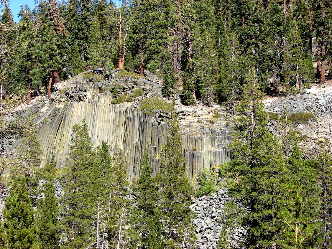
Tucked away in a small corner of an unheralded canyon of the Sierra Nevada is a real gem of a geological locality. It is a marvelous example of columnar jointing that has been modified by glacial scouring, and it's NOT called Devil's Postpile. Welcome to the Columns of the Giants.

The Stanislaus River doesn't quite have the panache of the Merced River, which flows through Yosemite Valley, or the Tuolumne River, the architect of Hetch Hetchy Valley. It's not protected as a national park like Kings Canyon. It had glaciers during the ice ages, but they didn't have the volumes of ice necessary to carve stunningly deep gorges like the previously mentioned river valleys. But it does have a grandeur all its own.


The headwaters of the Stanislaus expose rocks that are quite distinct from those of the other more famous rivers. The rocks have a darker aspect, due to being composed of relatively young volcanic rocks, rather than the granite that makes up three-quarters of the Sierra Nevada. Highway 108 crosses one of the uppermost tributaries at Sonora Pass (9,624 feet/2,933 meters), and travelers can get a spectacular view of these former volcanoes that were active about 10 million years ago. They erupted onto a muted landscape of eroded granitic rocks. Some of the eruptions produced flows that traveled more than fifty miles downstream through the canyons of the Ancestral Stanislaus River. Later erosion acting on these flows produced the famous Stanislaus Table Mountain in the vicinity of the Gold Rush Towns of Jamestown and Sonora.

Beginning around 2 million years ago, glaciers began tearing away at the higher parts of the Sierra Nevada, removing many of the volcanic flows and carving U-shaped gorges like the one above, visible just a few miles downstream of Sonora Pass at Chipmunk Flat. The ice age was not a single event. The ice advanced and retreated more than a dozen times, with warmer periods in between that lasted for thousands of years. It was during one of these interglacial periods that something extraordinary happened in the upper reaches of the Stanislaus River drainage. Roughly 150,000 years ago there was a volcanic eruption down in the canyon.

It wasn't a large eruption, certainly not on the scale of some of the rhyolite cataclysms that devastated the regions east of the Sierra crest 767,000 years ago. It was more of a mild cinder cone eruption that might have flooded a portion of the canyon, flowing just a few miles downstream before the lava flows ceased. Subsequent glaciations scoured away much of the remaining lavas, and river erosion removed still more. Hidden in a cleft, a basalt dike just upstream of the columns may be all that remains of the volcano responsible for the eruption. It's not much, just the fracture in the granite that filled with basalt that fed the eruptions above. 


The remains of the lava flow, though? Spectacular! The lava flow (or flows; there were possibly two of them) was ponded by some obstruction downstream, most likely a glacial moraine, and a modest lava lake developed, several tens of meters deep. As the lava cooled, it shrank and the rock fractured in generally hexagonal columns roughly perpendicular to the surface against which the lava flowed. Since the lava flows were erupted onto a canyon bottom with slopes on either side, not all of the columns are vertical (this is also true of the better-known Devil's Postpile). 

Subsequent glaciations (primarily the Tahoe and Tioga stages for those who want to know) tore away at the lava flow, exposing the columns. Over the last 10,000 years or so since the last Tioga glaciers melted away, frost wedging has pried many of the columns loose, dumping them into a vast talus slope that covers the base of the lava flow. Cold air emanating from the base of the talus suggests that a mass of ice might actually remain deep within the rockpile. 

Columns of the Giants can be easily visited by following Highway 108 about 25 miles east of the Pinecrest Lake Resort area or 13 miles west of Sonora Pass. Overnight accommodations can be found at nearby Kennedy Meadows and a number of National Forest campgrounds. Educational groups may be able to make arrangements to stay the High Sierra Institute at Baker Station just a few miles away (contact the Yosemite Community College District for more information).

Stanislaus National Forest has provided a parking area and simple toilets for visitors, and a paved ADA-compliant trail and bridge provides access. The trail is only a few hundred yards long, and the visual rewards are great. 

Can't get there in person? My friend and colleague Ryan Hollister put together a marvelous virtual field exercise that provides an experience that is the next best thing to being there. It was featured on NPR's Science Friday a few years ago.

Sunday, August 5, 2012

A Kid in a Candy Shop...On the Oregon Coast

A kid in a candy shop, that's what I was the other day. All the colorful stuff, not really paying attention to the details because there was so much going on. I was covering a lot of ground in a few short hours and our stops were unfortunately brief. The pictures today come from Seal Rock State Beach near Newport, a place with no seals, but some great rocks!

It was immediately apparent that we were looking at columnar jointing in basalt. Lockwood or Dana Hunter, my Pacific Northwestern geoblogging friends, can probably say a lot more about the geology (think of them as being the clerks in the candy shop, the ones who get to see this stuff a lot more often), but what little I can find in a cursory search is that these outcrops are part of a sill, an intrusion that squeezed between sedimentary layers about 14 million years ago.
The volcanic basalt cools and contracts as it reaches (or approaches) the surface. Since the entire mass can't shrink, the rock fractures at characteristic angles and orientations. At times, the contraction fractures form prominent columns, like those at Devil's Postpile, or the Giant's Causeway in Ireland. Columnar joints are interesting in any setting, but put the rocks on a coastline, and they become spectacular!
The largest outcrop is called Elephant Rock.The alcove at the base is a sedimentary layer called the Yaquina Formation. The soft underlying sandstone is easily eroded, causing the jointed rock above to collapse. In this way, the steep cliff retains its shape over time.

Elephant rock is the largest chunk of basalt but others form a wall of sorts along the shoreline.
It was such a pleasant surprise to run across these rocks. I usually research my travels ahead of time, but never had a chance this time around. It's all new to me, terra incognita so to speak, and it makes me wonder about what all that I missed on this very rushed trip. It's ok...several cherished relatives have just relocated to central Oregon, so I will have some good opportunities to check these places out a bit more carefully in the future.
Cool columnar jointing, or the Gates of Mordor??

Thursday, May 26, 2011

Water in a Dry Land: Joshua Tree National Park, and Getting Tanked


A lake in the desert? That can't be right...

Joshua Tree National Park has a bit of a schizophrenic aspect. Geologicially, the park is divided into vast tracts of metamorphic rock separated from large areas of granitic rock. Topographically, the park is divided into the higher Mojave Desert and the lower Colorado Desert (the High Desert and Low Desert of SoCal weather reports). The elevation and rock differences result in large contrasts in water availability, and thus vegetation; the iconic Joshua Tree is not found in the lower parts of the park, for instance.

The higher parts of the park exceed 3,500 feet, and the climate is cooler and wetter ("wetter" being a relative term), and this higher elevation desert even receives the occasional snow flurry in winter. My vivid memory of January camping at Joshua Tree as a Boy Scout was that of coldness, absolute extreme cold (probably merely close to freezing, but I was a southern Californian; we panic when the temperature drops below 50 degrees).

There's more water in the high desert, enough that the landscape could almost be classed as savanna. These higher elevations supported enough grass that a few ranchers scratched out a living in the region. Cattle need water, but the water doesn't flow at the surface much of anywhere in the park. The ranchers built a few small dams in scattered drainages to catch the runoff from rare rainstorms. These so-called tanks were of varying quality, and some have fallen into such disrepair that they no longer hold water, but others survive. One of the nicer (and popular) short hikes in the park visits Barker Dam in the Wonderland of Rocks area. We had a pleasant stroll there last week, on a sparkling clear day.

With a bit of revegetation effort and pathway control, one can see how grasses could almost support a cow, although the measure would be acres per cow rather than cows per acre. The grazing no doubt put severe pressure on the local population of bighorn sheep, who are occasionally seen in the vicinity of the reservoir.
The trail winds past some unique desert oak trees and a variety of yucca called Parry Nolina, which blooms into the showy stalks seen in the picture above. The bedrock in the area is entirely composed of a variety of granite called monzogranite, which formed deep underground as magma, and cooled slowly to produce the crystal-rich rock. As the granitic rock was exposed at the surface, expansion and stresses caused the rock to fracture along joints which became the focal point of weathering and erosion. The boulders weather more readily at corners and edges, giving them a rounded aspect. The process is called spheroidal weathering.
Closer to the dam, the rock is less jointed, and breaks mostly parallel to the surface, forming a dome-like structure, which is a relatively rare sight at Joshua Tree, and more familiar in places like the Sierra Nevada. This is the process of exfoliation (below).
The little reservoir captures the rare runoff from thunderstorms, and the resulting lake attracts all manner of birds, insects, mammals and other creatures, including tourists.
A look at the dam reveals what probably amounts to a lack of sophisticated dam engineering, but it has lasted for more than sixty years.
The area downstream of the dam is a beautiful landscape of rock and vegetation. A number of petroglyphs and pictographs (some unfortunately recent) can be found hidden in these rocks. The ranchers had probably built on top of a natural reservoir in the rock, and the area has been a source of water for a long time.
So what about these Joshua Trees? Is there anything geological about them? That will be next time...

Wednesday, September 29, 2010

Columns on Columns: Pictures all over the Joint!

I was so pleased to see all the columns showing up in the geoblogosphere this week! Columnar-jointed columns that is. I added to the cacophony with shots from my field trip last week to Devils Postpile and the Owens Gorge east of the Sierra Nevada. The great collection of pictures that followed have been linked by Lockwood at Outside the Interzone. Check them out!

The meme reminded me of one of the greatest exposures of columns I've ever seen in my travels: they were along the east coast of the Isle of Skye in Scotland at Mealt Fall. Mealt Fall plunges over the sheer cliff and almost right into the sea. The cliffs are vertically jointed basalt flows that are related to the opening of the Atlantic Ocean in late Mesozoic and early Cenozoic time.
When I got on the plane for the Scotland trip in 2001, I had taken a grand total of 3 pictures on my very first digital camera. I barely knew what I was doing, and took only a handful of high resolution shots on one of the greatest trips of my life. I wish I could do the whole trip again, though, with the camera and experience I have now (and isn't just about all of life like that?).
Here are some of the columns lying on the beach below the cliffs.

I got a note from a geology student in Argentina, Ivan Ivanyvienen, who offered up an additional photo of columnar jointing in rhyolite at the San Juan Precordillera. It's a great shot and he has given permission to show it here on Geotripper. Thanks!

Sunday, September 26, 2010

Columns on Columns: Other Jointing Stories This Week

The vertical columnar joints that I saw at Devils Postpile weren't the only columns we saw on the field trip last week. We paid a visit to the Owens River Gorge on the Volcanic Tableland north of Bishop, California. The vast mesa is a rhyolite plateau that preserves a record of the one of the greatest explosions ever to shake North America, the eruption of the Long Valley Caldera. The 125 cubic miles of ash that was blasted into the sky 730,000 years ago produced the Bishop Tuff, which has been found across the western United States and as far east as Nebraska and Kansas. The giant explosion vacated a massive magma chamber, which subsequently collapsed, producing a hole two miles deep, ten miles wide, and 20 miles across. The caldera was partly filled with ash, but over the years a huge lake accumulated. When it finally spilled over the edge of the caldera, the new Owens River rapidly carved the gorge 400 feet deep. Along the way, the river exposed the columnar joints that developed as the hot ash settled, partly remelted, then cooled and contracted. They are easily accessed from one of the power station roads maintained by the Los Angeles Department of Water and Power.

As I was writing about the columnar jointing at Devils Postpile National Monument, it occurred to me that I had seen a number of geoblogosphere posts that involved the phenomenon in the last couple of days. Do posts by five bloggers make it columnar jointing week?

The youngest geoblogger, Sam at Geology Blues, has a note on Devils Tower.

Looking for Detachment's Silver Fox posted some beautiful pictures of Deep Creek Falls in Oregon, which thunder over some basalt columns. Then there were her pictures of jointing in basalt in the same general region, a Friday Mystery Photo.

Last Thursday it was Philip at Geology Blues with a picture of columnar joints in basalts on his commute in Oregon.

Though columnar joints aren't specifically mentioned, Glacial Till has pictures of the Columbia River Gorge and some of the basalt columns appear in the cliffs. Till writes of a new appreciation of the geology there.

A Column on Columns: Tuesday's Mystery Photo and the Devil's Work

It didn't take folks very long to figure out that Tuesday's mystery photo was taken in the vicinity of Devils Postpile at the national monument of the same name. Devils Postpile is justly famous as a stunning example of columnar jointing in a volcanic rock, and the vertical columns seen here are relatively rare around the world (Devils Tower in Wyoming and the Giants Causeway in Ireland are well-known examples). Most pictures and descriptions of the columns concentrate on a view from the base (above)...
...or the view from the top, looking down on the massive talus pile at the base. The Postpile gained monument status in 1911 after someone floated the brilliant idea of dynamiting the columns and using them to construct a dam across the adjacent San Joaquin River. Kind of like using the meadows of Yosemite to graze sheep, or strip-mining Death Valley National Park (both of which happened).

The Postpile formed when a lava flow around 100,000 years ago was dammed by glacial deposits to a depth of around 400 foot. The pool of lava took time to cool, with heat transferred to the rock below and the surface of the lava above. As the rock cooled, it contracted and cracked into the symmetrical spires that make up the cliff.
Somewhat more than half the columns have six sides, but the total number of sides ranges from three to eight. The best place to see the symmetry of the columns is from the top of the cliff where glacial scouring has smoothed off the top of the flow (and what a great example of glacial polish and striations!)
The pictures I posted on Tuesday (here and here) illustrated one of the interesting angles on the Postpile that don't show up in most of the pictures in brochures and vacation pictures. Many of the columns go off in strange diagonal directions (which is more normal in columnar jointing of most lava flows). Take a look below at a rather rarer view of the Devils Postpile from across the river (there is a trail somewhere over there, but I didn't find it. I was bushwhacking to get this shot!). Click on the picture to see a larger version (and the people sitting on the top for scale). The vertical columns are bookended by diagonal columns.
Crossing the stream (it was fall; this isn't recommended in the early summer when the river runs full!), a series of stunning diagonal columns are exposed at river level. These are seen by a small fraction of the visitors to the monument.
At the south end of the Postpile, the columns go in all directions (below). The pictures on Tuesday were taken on the flank of this side of the Postpile, where glacial plucking had broken and removed the tops of the columns rather than scouring them. Another ice age and the Devils Postpile could very well disappear entirely.
Devils Postpile National Monument is a fascinating visit for anyone interested in volcanism and glaciation. It lies over the crest of the Sierra Nevada from Mammoth Lakes along a drive that passes over Minaret Summit with a stunning (there's that word again, it comes up a lot when I explore the Sierra Nevada) view of the Minarets and Mounts Ritter and Banner, perhaps to show up in a future post. Because of limited parking and overcrowding, the park service long ago instituted a shuttle bus to ferry people from the Mammoth Mountain ski area during the summer months (including a fee). You can drive down if you have camping reservations, or in late September or October before snowstorms close the road. Fees are charged, but schools may be able to get fee waivers if they contact the Park Service or U.S. Forest Service prior to arriving (both agencies have jurisdiction). The Pacific Crest and John Muir Trails both pass through the monument.

Some other very nice examples of columnar jointing can be found along Highway 108 over Sonora Pass (the Columns of the Giants), and in Yosemite National Park along the Tuolumne River near Glen Aulin.