 |
| Alabama Hills near Movie Flats |
I picked out some more scenes from our recent field studies class in the eastern Sierra Nevada and Owens Valley. Above, the Alabama Hills expose granitic rock essentially similar to that of the rugged high Sierra. It looks different because it weathered beneath the surface, possibly in more subtropical conditions. Cracks and fractures allow water to seep onto the surface of the granite, breaking the feldspar minerals down to clay and removing corners and edges over time.
 |
| Devil's Postpile National Monument near the headwaters of the San Joaquin River |
The Devil's Postpile is a famous example of a different process of breaking up rock. When lavas flows back up and form pools, the cooling rock contracts and fractures into hexagonal shapes (although columns with 4, 5, and 7 sides are known). It is somewhat unusual to see such straight columns; they usually are far more irregular.
 |
| Mamie Lake at Mammoth Lakes |
The Mammoth Lakes are a series of beautiful glacially carved tarns (some enhanced by small power generating dams). Mamie Lake is seen above, and the Twin Lakes below.
A storm blew through in the midst of our journey. The morning after brought smoke-free conditions and beautiful sunlight through the clouds. The picture below shows Mt. Tom and Mt. Humphreys west of the town of Bishop in the Owens Valley.
One of the best ways to see the Sierra Nevada is to view the range from the next ridge over. The White Mountains in any other setting would be a celebrated National Park. It is a stunning wall of rock with unique topography and unique biology. We climbed the road to the Schulman Grove of Bristlecone Pines across from the Palisades Crest of the Sierra Nevada.
 |
| Palisades Crest from the White Mountains. The Owens Valley is in the foreground. |
The Palisades Crest is home to the largest remaining glaciers in the Sierra Nevada. The biggest is about a half mile long and a mile wide. In this drought year, few snow patches were left...pretty much all the ice you see in the picture above is a glacier.
The Bristlecones are special trees. Besides living in one of the toughest environments of any tree in the world (two miles in elevation, with a two or three month growing season), they grow to great antiquity. The oldest discovered thus far is more than 5,000 years in age.
The trees subsist in nutrient poor soils, but even poor soils are better than the barren debris formed on pure quartzite. The forest ends abruptly where the Cambrian quartzite begins.
The day included a spectacular view of clouds curling around the summit of Mt. Whitney (14,505 feet; 4,421 meters), the highest mountain in the lower 48 states. The spheroidally weathered boulders of granite in the Alabama Hills can be seen in the foreground.
The last day of our trip was clear, providing a beautiful view of the metamorphic rocks above Convict Lake south of Mammoth Lakes, and the tufa towers at Mono Lake. Some detailed geologic descriptions of these fascinating places are in the works for a future blog post.


 It didn't take folks very long to figure out that Tuesday's mystery photo was taken in the vicinity of Devils Postpile at the national monument of the same name. Devils Postpile is justly famous as a stunning example of columnar jointing in a volcanic rock, and the vertical columns seen here are relatively rare around the world (Devils Tower in Wyoming and the Giants Causeway in Ireland are well-known examples). Most pictures and descriptions of the columns concentrate on a view from the base (above)...
 ...or the view from the top, looking down on the massive talus pile at the base. The Postpile gained monument status in 1911 after someone floated the brilliant idea of dynamiting the columns and using them to construct a dam across the adjacent San Joaquin River. Kind of like using the meadows of Yosemite to graze sheep, or strip-mining Death Valley National Park (both of which happened).
 Somewhat more than half the columns have six sides, but the total number of sides ranges from three to eight. The best place to see the symmetry of the columns is from the top of the cliff where glacial scouring has smoothed off the top of the flow (and what a great example of glacial polish and striations!)
 The pictures I posted on Tuesday (here and here) illustrated one of the interesting angles on the Postpile that don't show up in most of the pictures in brochures and vacation pictures. Many of the columns go off in strange diagonal directions (which is more normal in columnar jointing of most lava flows). Take a look below at a rather rarer view of the Devils Postpile from across the river (there is a trail somewhere over there, but I didn't find it. I was bushwhacking to get this shot!). Click on the picture to see a larger version (and the people sitting on the top for scale). The vertical columns are bookended by diagonal columns.
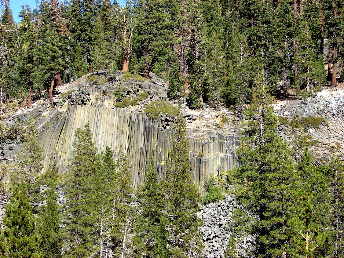 Crossing the stream (it was fall; this isn't recommended in the early summer when the river runs full!), a series of stunning diagonal columns are exposed at river level. These are seen by a small fraction of the visitors to the monument.
 At the south end of the Postpile, the columns go in all directions (below). The pictures on Tuesday were taken on the flank of this side of the Postpile, where glacial plucking had broken and removed the tops of the columns rather than scouring them. Another ice age and the Devils Postpile could very well disappear entirely.
 Devils Postpile National Monument is a fascinating visit for anyone interested in volcanism and glaciation. It lies over the crest of the Sierra Nevada from Mammoth Lakes along a drive that passes over Minaret Summit with a stunning (there's that word again, it comes up a lot when I explore the Sierra Nevada) view of the Minarets and Mounts Ritter and Banner, perhaps to show up in a future post. Because of limited parking and overcrowding, the park service long ago instituted a shuttle bus to ferry people from the Mammoth Mountain ski area during the summer months (including a fee). You can drive down if you have camping reservations, or in late September or October before snowstorms close the road. Fees are charged, but schools may be able to get fee waivers if they contact the Park Service or U.S. Forest Service prior to arriving (both agencies have jurisdiction). The Pacific Crest and John Muir Trails both pass through the monument.


