Showing posts with label Roche Moutonnee. Show all posts

Thursday, August 27, 2015

Vagabonding on Dangerous Ground: Seeing Volcanoes from the Inside Out at Siám' Smánit (Stawamus Chief)

It's one thing to talk about a subduction zone from the outside, where one might see an oceanic trench, or a chain of volcanoes. It's quite another to explore the convergent zone from the inside out, by, for instance, standing under the volcano. Miles below the volcano. That's what one gets to do along the lower stretches of the Sea to Sky Highway between Whistler and Vancouver in British Columbia.

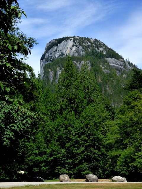
We were vagabonding our way through the landscapes of the Cascadia Subduction Zone between Northern California and the southern end of British Columbia. We were headed south towards home, but there were still some pretty intense sights ahead. As we drove down the Sea to Sky Highway back towards Vancouver, we had a chance to check out the awesome cliff of Siám' Smánit, Stawamus Chief at the head of Howe Sound. We got our first look of the immense cliff from several miles upstream at the Tantalus Overlook (below).
Stawamus Chief is a huge cliff and dome of granitic rock, specifically granodiorite (which chemically is a bit less rich in silica than actual granite). The chief has a height of 700 meters (2,297 feet), which is only a few hundred meters short of El Capitan in Yosemite National Park (900 meters, 3,000 feet). Interestingly, both names refer to "chiefs". The rock originated in magma chambers many kilometers below the surface of the Earth, underneath volcanoes that are presumed to have existed far above about 100 million years ago (the Cretaceous Period; dinosaurs would have wandered the slopes of these volcanoes). Tens of millions of years of erosion have removed the volcanoes and the many kilometers of intervening rock. We were quite literally standing within the internal plumbing of an ancient volcano!

One of the agents of erosion that has shaped Stawamus Chief was glaciation. We were at the head of Howe Sound, North America's southernmost glacial fjord, a spot where the ice stream was thousands of meters thick. The ice completely covered the "Chief" and eventually scoured and trimmed the edges of the huge rock.

In the 12,000 years or so since the ice melted back, the scoured and polished surfaces of the rock were weathered away, or buried beneath rock debris. Fresh looking glacial surfaces can be hard to find at times, but the 2010 Winter Olympics provided some excellent exposures here at Stawamus. How? The organizers widened the highway, and constructed a pedestrian bridge that provided access to the provincial park for people parking to the north.
The slopes in the Stawamus area were covered with glacial till and outwash deposits that hid the scoured granite surfaces. Engineers cut a low pass through the till. but they realized that the loose debris would be a road hazard. They carted away the till, exposing the beautifully carved and polished surfaces underneath.

Some of the till was still visible on the south side of the highway (below).

From north of the bridge, even more of the immense cliff could be seen. The mountain attracts legions of rock climbers, and we could see several of them inching their way up the rock face.

It was getting late, and the vagabonders had made no plans for the night. We continued down the highway, eventually finding accommodations in North Vancouver. The next day we would be making the border crossing back into the United States, where new adventures awaited. More to come!
Monday, August 17, 2015

Vagabonding on Dangerous Ground: Stone Rings, Glaciers, and "Dinosaurs" on the Coast of the Salish Sea

We've got a mixed bag on this post...

Our vagabonding trip along the Cascadia Subduction Zone involved a desire to spend most nights camping, but we now we had reached Canada, our gear was all wet, and we were in one of the most beautiful cities in the world, Victoria. We decided to spend a few days in the comfort of a hotel and dry out a bit.

Victoria is an architecturally scenic city, but it is also a city of geology and archaeology. Some of the best parts are found in city parks like Beacon Hill and a series of shoreline green areas (although not so green in this dry year). We spent some time here last year, but I was flabbergasted to find I had missed an obvious link to the past that had been in plain view. It was a group of stone rings on the slope of Beacon Hill above Finlayson Point, right next to Mile Zero of the Trans-Canada Highway.
The stone rings were burial sites of the First Nation Songhees people. When Europeans established the city in the middle 1800s, there were several dozen of these rings on the hill, but the new colonizers were not particularly interested in preserving evidence of the past. They removed most of the stones and used them elsewhere. By the 1980s only four rings remained on the slope below Beacon Hill, hidden from sight by a thick growth of vegetation. In 1986, the parks department removed the vegetation, and then bulldozed the stone rings to facilitate mowing. They didn't realize what they were doing. Archaeologists directed to crews to replace the stones as best as could be remembered, and there were promises to protected the site and to provide interpretive signage. A low fence surrounds the rings, but when we were there, I didn't see any signs explaining the site.
The parks in the city of Victoria are good places to see the only dinosaurs remaining on planet Earth. They are of course the avian dinosaurs, the only members of the dinosaurian clan to survive the great extinction event at the end of the Cretaceous period. At Beacon Hill, we saw several large bird species, including a Peacock. Seen only from the knees down, they look terrifying, as scary as any T-rex.
There was also a rookery of Great Blue Herons. A juvenile was hanging out in the low branches of a tree by the pond, and the adults seemed to be patrolling the area from high perches in the tallest trees. Every few minutes they erupted into an other-worldly shrieking, and there was a commotion up in the crowns of the trees. We couldn't see what they were upset about.
After a few minutes the reason became clear. They were at war with raptors. There was a pair of Bald Eagles trying to attack the nestlings and eggs in the rookery. It was a life and death battle going on over our heads (for more pictures of the event, check out my story at Geotripper's California Birds).
We continued along the coast to take in the coastal parks, and to climb one of the highest peaks in the Victoria area. It was a good way to see evidence of the glacial heritage of this landscape.
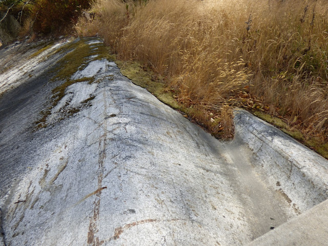
Direct evidence exists for only two advances of glacial ice across this region, but there were undoubtedly many more. The youngest events tended to erase the deposits of the earlier advances of ice. Soils obscure many of the glacially carved rocks, so the best place to search for glacial features was along the coastline where wave erosion removes the soil cover. 
The coastal drive provided many examples of glacial polish, striations, and grooves. The smoothed off rocks provided clear exposures of the ancient metamorphic rocks that underlie this part of Vancouver Island. The rocks are called the Wark or Colquitz gneiss, and they formed as part of Wrangellia, a terrane that formed hundreds or thousands of miles away across the Pacific. It was accreted to the North American continent about 100 million years ago during the Cretaceous Period. I had a pleasant teaching moment when some older ladies who were enjoying the view wondered why the strange man was taking pictures of the rocks rather than the coastline. They politely said thank you at the end of the long explanation (I get that a lot).
We then drove to the top of Mount Douglas (known by the Saanich people as pq̕áls or PKOLS), a 260 m (853 ft) hill that rises over Victoria, providing a 360 degree view of the region. The mountain provides several different biologic zones, including a Garry Oak woodland around the summit, one of the northernmost exposures of oak trees in North America. The lower slopes are covered by conifer forests.
The view is fantastic. It really is a wonderful spot to gain an appreciation of the regional geography. The Olympic Mountains were visible across the Strait of Juan de Fuca, and I'm told that Mt. Rainier is visible on the clearest days (it's over 130 miles away). The entire city of Victoria spreads out to the south.
To the north is the Saanich Peninsula, and the glacially scoured Strait of Georgia, the northern extension of the Salish Sea. The mountains of Vancouver Island recede into the distance. The island is huge, 460 kilometres (290 miles) in length and 80 kilometres (50 miles) in width.
The next day was a layover for us, and we mostly pretended to be tourists, visiting Butchart Gardens (you can read my somewhat heretical review of the place here). The following day we were going to be seafarers once more, crossing the Strait of Georgia onto the Canadian mainland, and the Sea to the Sky Highway. I was anxiously watching the weather, because we traveled there last year, and never saw it because of low overcast conditions. What would we would see?