|
| Porteau Cove Provincial Park |
We are continuing our "
Northern Convergence" journey through Canada and the Pacific Northwest. Our last post saw us observing the geology in and around
Vancouver Island and Goldstream Provincial Park, and having a look at the
story poles (totem poles) of the First Nations people. That evening we caught the ferry to North Vancouver. The new day would see us heading into the mainland interior along the Sea to the Sky Highway to Whistler, British Columbia. Of all the our planned tours, this was the day I anticipated the most.
It's funny sometimes how perfect the weather is in promotional
materials. No matter the climate, pictures of tourist destinations are
always bathed in sunlight. It's clear that the most important item on
the luggage list is sunscreen. Oh, that it were like that in real life!
The
problem with a field studies class in a foreign country is that the
schedule is very rigid. Reservations have to be made months in advance,
and though we might try to schedule for times when the weather might be
the best, there is just no way to know. Much of the region is
technically a rainforest. It rains (and snows). Your best bet is always flexibility. Stay in one place for a week, Vancouver, say, and wait for the sunny days. They have great museums in the area for those gloomy ones. We didn't have that luxury, unfortunately.
 |
| Porteau Cove Provincial Park |
The day's route, the Sea to the Sky Highway, follows Canada's Highway 99 from Vancouver through Howe Sound to the mountain towns of Whistler and Pemberton. We were traversing the Coastal Belt, a geologic province that shows the effects of convergence, both in the past, and ongoing today.
The Cascadia Subduction Zone has been plunging beneath the western edge of North America for tens of millions of years. The sinking slab is heated, and parts of it (under the influence of water in the rock and sediments) melts, forming plutons of magma. The molten rock is buoyant and rises through the crust, sometimes reaching the surface as volcanic eruptions, but much of it remains at depth, cooling slowly to form granitic rock. Uplift and erosion has exposed the deep-forming rocks at the surface.
 |
| Porteau Cove Provincial Park |
The highway hugs the base of the cliffs on the south side of Howe Sound, a deep glacial fjord, one of the southernmost on the Pacific coast of North America. The weather, true to the predictions, was overcast and rainy. There was some hope that it might clear later in the day. Since we couldn't look upwards, we concentrated on the rocks in front of us. We made our first stop at Porteau Cove Provincial Park, one of the few accessible shorelines along the steep walls of Howe Sound.

The park is popular with divers, but there is plenty to see in the rocks and on the shoreline as well. Across the highway we could see exfoliating sheets of granitic rock, which in most other places are covered with thick vegetation. We didn't have to beat on any rocks to see the minerals because the railroad hugs the cliff here as well, and they used granitic rock for the track bed. The phenomenon of exfoliation is a problem in this area. Because the breaks slope towards the shoreline, rockfalls are a constant hazard, and the highway is sometimes disrupted. Porteau Cove actually has an emergency ferry terminal for when the highway is blocked.
The cove and beach exists in part because there is a large recessional moraine hidden within the waters of Howe Sound, and Porteau Cove is part of its southern margin. As the ice age was ending, debris formed a ridge around the end of the glacier when it briefly stabilized.
It was a quiet morning, and few people were hanging about. We took our time, hoping for a bit of the storm to clear. No dice. We headed up the highway towards our next stop, Shannon Falls Provincial Park. Along the way we passed the Britannia copper mine, long shut down, but now hosting a mineral and mining museum. The mine produced around $1.3 billion of copper and was the largest such mine in the British Empire. Shortly afterwards we arrived at Shannon Falls. Was there something up there in the mist? The clouds were playing a tantalizing game with us.

Shannon Falls are the third highest in British Columbia at 335 meters (1,105 feet). They are a fine example of a hanging valley, caused when the main Squamish glacier cut the very deep Howe Sound while the smaller glacier on Shannon Creek could not keep up. When the ice receded, the valley floor entered Howe Sound at a high elevation, so a waterfall resulted. Along the short trail to the falls overlook we could see a boulder with glacial striations.
Then the clouds parted and we got to have a view of the waterfalls! They were spectacular. They didn't fall over a single cliff, and instead rolled over a series of high ledges.
From the lower viewpoint, the whitewater seemed to be everywhere...
The clouds continued to lift and we finally had a view of the flank of Stawamus Chief, a 700 meter high dome of granitic rock. Although partly shaped by glacial ice, the dome shape results as much from exfoliation of the corners and edges of the granite monolith.
The clearing conditions ignited a spark of hope that we might see the big volcanoes among the high ridges above, Mt. Garibaldi and Black Tusk. As we reached the end of Howe Sound and started ascending the valley, those hopes were dashed. The cloud deck was impenetrable. Our remaining stops on the Sea to the Sky would need to be of the up-close variety.
Our next stop was Brandywine Falls Provincial Park. The rocks took a decidedly different appearance. Hidden in the clouds were two volcanoes, Garibaldi and Black Tusk, and volcanic flows covered exposures of the granitic rocks. A series of lava flows covered the path of Brandywine Creek. The slopes along the creek were covered with hexagonal chunks of basaltic lava broken from the low cliffs above us. The lava flow had cooled and contracted into a large number of columnar joints.
The lava flows followed a sinuous path along a former river drainage, forming what we would call an inverted stream, but which the park info described as a volcanic esker (eskers are stream deposits from rivers that flowed on or through glaciers). The flows are only a few tens of thousands of years old.
And then we broke out of the forest and found ourselves looking at marvelous Brandywine Falls. At 70 meters (230 feet), they make a single drop off the edge of the lava. Brandywine Falls formed in a different manner than Shannon. The top layer of basalt is more resistant than the others, so the underlying rocks are constantly being eroded and carried away. The lip of the waterfall is moving slowly upstream in an example of headward erosion.
After observing the falls and lava flows we headed into Whistler for lunch. It was unexpectedly crowded, and we soon realized we had stumbled upon preparations for an ironman triathlon. We scattered through the village, and were quickly reminded that Whistler was once a venue for the 2010 Winter Olympics. We had miles to go, and soon hit the road. As we made our way east through Pemberton and beyond, the clouds cleared and we were bathed in sunshine. We had reached the rain shadow of the Coastal Ranges.
We missed some things, but I had to count ourselves lucky for seeing two thirds of our scheduled sights. Yet I couldn't help being a bit disappointed at missing the big volcanoes. It doesn't take long to find what the sights are like on the internet, so I've including a few of them below.
I have to give credit where credit is due. This video shows more of the scenery than we saw on our way to Whistler, but it also shows rain and cloudy skies!
These scenes are mostly courtesy of
Destination British Columbia (and no, I don't blame them for putting their best foot forward! The scenery is truly spectacular.).
Below is Howe Sound and Highway 99 on a cloudless day.
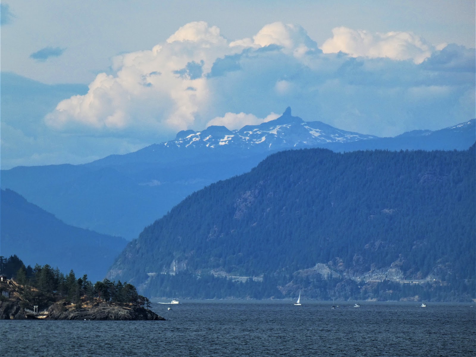
The Black Tusk is the deeply eroded remnant of a volcanic cone. It is a former stratovolcano between and 1.3 and 1.1 million years old. A late eruption about 170,000 years ago formed the dark cone at the summit.
The peak of Mount Garibaldi is one of the more interesting of the Cascades volcanoes (and one of the northernmost). It began erupting dacite (silica-rich) lavas about 250,000 years ago. The most recent activity was around 8,000 years ago, so it has to be considered potentially active. The volcano erupted in part on an active glacier, and when the ice ages ended, a large portion of the volcano fell away into the Cheekye Valley.
I've got to get to this region in clear weather one day!
There is an excellent guide to the Sea to the Sky Highway avail
able online:
Turner, B; Kelman, M; Ulmi, M; Turner, T.,
Sea to Sky GeoTour, geology and landscapes along Highway 99 from Vancouver to Whistler, British Columbia, Geological Survey of Canada, Miscellaneous G 377E