Wednesday, October 23, 2013

Rivers Appearing Out of Nowhere: McArthur-Burney Falls State Park

Note: Sorry for the odd character of the photos. My hike was at dusk, and lighting was difficult!

There's no doubt that McArthur-Burney Falls are absolutely spectacular, almost otherworldly. Burney Creek spills over a high ledge of basalt and is joined by myriads of whitewater springs bursting out of the cliff below. It falls into a gigantic deep blue pool of water before flowing down to the reservoir a mile or so downstream.
It is cool and moist even in the driest and hottest part of the year, because the springs that feed the fall are practically impervious to seasonal changes. A lot of water passes through the park each day, something like 100 million gallons every 24 hours.

The geology is interesting. The region includes horizontal flows of basaltic rock along with intervening layers of lake sediments and diatomite. The basalt is jointed and broken up and allows water to sink quickly into the ground (surface streams are surprisingly rare in this wet climate). The diatomite and siltstone layers are impermeable and don't allow water to sink deeper into the ground. It is instead forced to flow sideways until it flows out at a spring such as those in the face of McArthur-Burney Falls
What makes the falls more intriguing is the incredible contrast between the river downstream and upstream of the falls. Downstream, Burney Creek has a sizable flow, as seen below.

I decided to check out the river upstream of the falls and headed up the trail. Fall colors were just beginning to make an appearance.
I can now say I spent some time this summer on the Pacific Crest Trail. A whole mile of it, in fact! It runs through McArthur-Burney Falls State Park on the west side of the creek. It was quiet and quite devoid of other hikers on the Sunday evening when I was exploring.
At the upstream end of the park, Burney Creek is AWOL. There is only a dry channel lined with basalt boulders, aspens and willows.

Making my way downstream, I found a spot where the river appears as a series of pools, but at this point it is not yet flowing. The water table is intersecting the channel of the stream and rising to the surface.
Just a bit further downstream, the river has grown, and after a few hundred yards more, it is a large stream that makes the bold leap over the ledge of basalt.
This has been a strange landscape we have been traveling through, an entire shield volcano with no surface water beyond a glacial lake at the summit caldera, and a lava plateau, also with limited water. Yet the climate is wet, and is ultimately the source for much of the water flowing in the Sacramento River.

I headed back to camp. Tomorrow was the last day of the field class, and we were going to pay a visit to Lassen Volcanic National Park!

Sunday, October 20, 2013

It's Just a Damned Rock...or Stalactite...or Wolf...or National Park. Where does it stop?


The subject of today's post grew out of several news items from the past few weeks, and a walk underground that I took yesterday.

I'm going to start with a bit of a mental exercise. Imagine a cavern in a place like the Sierra Nevada foothills, a cave that was discovered by miners in the 1850s, and offered up as tourist stop for the next 30 years or so. Think how attitudes about caves differed in those days. Visitors regularly broke off stalactites as souvenirs, and many carved or wrote their names on the walls. Imagine a cave where such activities continued until few speleothems (cave decorations like stalactites and stalagmites) were left, and people lost interest in visiting the site. It fell into disuse and was abandoned, forgotten by all but a few spelunkers, and even they rarely visited.

Skip forward a century or so. Spelunkers explore the cave, and find some indications of deeper passageways, maybe a pile of rubble, or perhaps a cool breeze coming from a small crack in the wall. They start removing the rubble, and realize that a narrow passage may reach into deeper recesses never discovered by the miners and early tourists. Weeks of work and they break through into a new room, a room never before seen by human eyes. A room full of stalactites and other features never broken off or smudged by soot. As a geologist and explorer of the Earth, I've dreamed of doing something like this, but I can't quite fit in the tight passages the way I used to in my youth (not to mention a sense of claustrophobia!). Luckily we can experience something like this discovery in several of California's beautiful caverns, especially Black Chasm, and the subject of today's photography, California Cavern. We visited yesterday as part of a field studies class in the Sierra Nevada foothills.

California Cavern is owned and operated privately, and some parts of the cavern system are utilized extensively for recreation, but they've done a good job of protecting the gem of a room that was discovered in the late 1980's. It's called the Jungle Room and it is full of some of the most delicate speleothems I've ever seen. The most extraordinary are the soda straws, thin long stalactites that look so delicate that a single touch could break them off. And they haven't been broken.
The tour guides spend their time in the first barren looking rooms talking about how the miners and early tourists used to use this room for court, that room for meetings and this other room for preaching or marriage ceremonies. They point out the carvings and other graffiti on the walls, but mostly what I see is destruction of anything within the reach of hands or long sticks. It is sad to think of what was lost in the inkling of time, those few years out of hundreds of thousands that humans entered into these underground openings.
I don't think that the early visitors acted out of maliciousness, just ignorance, but I am seeing a new class of people these days, destructive people who wish only to destroy, for reasons I cannot begin to fathom. I think of the arsonists who would destroy ancient forests, and people who would take advantage of a government shutdown to invade and destroy the beautiful parts of our national parks and monuments.

I wonder if that idiot Representative Randy Neugebauer, who berated a park ranger who was (unhappily) erecting barriers at one of our war memorials, gave even a moment's thought to what could have happened if the park service left the memorials unprotected and unpatrolled. All over the country, terrible people wandered into parks, leaving behind vandalized facilities and obscene messages.
Caves can sometimes be protected behind locked doors, but other caves are unprotected. Every year more damage is done. And sometimes those responsible will say things like "it's just a single damned stalactite, it's just a single rock, it's just a single wolf I shot", it's whatever someone felt justified in destroying. And since we find that corporations are "people too", we have corporations who say "it's just another damn forest, or river, or meadow" that we want to develop, or log, or mine. What will it hurt to destroy just one more?
I love seeing perfection. It happens so rarely, and it is always so fragile. That's what I was able to observe yesterday, deep inside the mountainside. Our Earth is fragile too, and we've already done so much damage.
On the way out of the cave after our tour I noticed something that I hadn't seen before. Some of the stalactites were repairing themselves! It was only the littlest change, but some of the soda straws and stalactites were growing again, and I realized that in at least some caves, the features may return, probably long after we humans have become extinct and perhaps replaced by beings with a better sense of beauty. It left me with a little bit of hope.

So I end with the morons in Utah's beautiful Goblin Valley, one of my favorite places to visit. Yeah, it's just another damned rock. Who really cares if we push it over? There are hundreds of others. What will it hurt? And besides, they were "saving lives". They are morons, maybe, and deserving of punishment. Because I love places like Goblin Valley, my first impulse is that they ought to go to prison, but on second thought, it might be better if they get a sentence of community service, hopefully teaching others the importance of protecting the wild places instead of destroying them. It's not likely that the message will sink in, but one can hope.
 

Friday, October 18, 2013

Scenes from a Shield: Isn't This Supposed to be Basalt?

Medicine Lake Highland (from an earlier trip when it wasn't covered with storm clouds).
Medicine Lake Highland at first glance sure looks like a classic version of a shield volcano. The gently sloping flanks indicate the presence of non-viscous basaltic lava, and the lava tubes we explored were certainly composed of basalt. As we moved further up the flanks of the mountain we encountered tree molds (those were the mystery holes in the previous post, as Lockwood correctly surmised) that also occur in basalt flows. By the time we reached the summit of the volcano and the caldera at Medicine Lake we were starting to see different kinds of lava. Some gray colored andesite could be seen on the north flank of the caldera.

The most striking kind of lava was what we saw at Glass Mountain, the most recent lava flow on the mountain, dating to only 900 years ago.

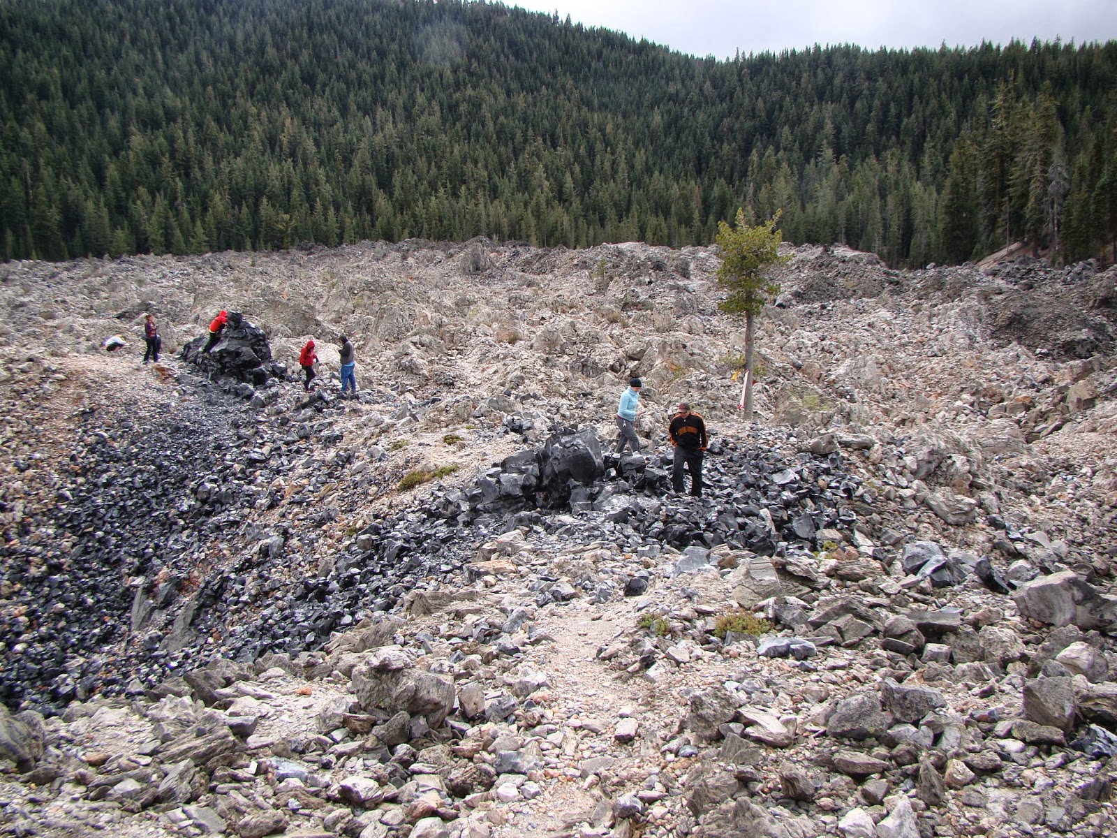
Everything about Glass Mountain is a complete contrast to basalt. The steep debris-covered flanks of Glass Mountain show that the lava flow was highly viscous and barely able to flow at all. The light color of the lava contrasts sharply with the black of basalt. The mountain is composed mostly of obsidian and pumice, glassy rocks that usually have a chemical composition equivalent to rhyolite.  
Glass Mountain is a typical example of a plug dome. Such volcanoes are small, usually no more than a thousand feet tall, with steep rubble-covered sides. The lava flows from the cone are rarely very long, and are thick and very rugged.

One might wonder what rhyolite is doing on the summit of a gigantic basaltic shield volcano. Such things are not usually seen on Hawaiian shields, for instance. A bit of information about the melting points of minerals and the composition of the crust can help us to understand what happened on Medicine Lake Highland.

The minerals found in basalt have high melting points. For basalt to be in a liquid state requires temperatures of 2,000 °F or more. Rhyolite on the other hand contains minerals that melt at lower temperatures, maybe in the range of 1,300 °F.

Oceanic crust is essentially composed of basaltic rock. Continental crust is more granitic in composition, and granite is what you get if rhyolite cools very slowly (granite and rhyolite are made of the same minerals, in other words).

Medicine Lake Highland is situated on the diffuse boundary between the Cascades Province and the Basin and Range, a region that is being stretched or extended in an east-west direction. The extension is causing faults to form in the crust, and the faults are allowing basalt to approach the surface from its source in the Earth's mantle. The basalt magma, as noted, is very hot.

As the basalt rises through the thick granitic crust, the intense heat causes melting of the granite, and magma chambers form that are composed of rhyolite. The basalt and rhyolite magmas don't play well together, and don't readily mix. As a result, some eruptions are basaltic, and others rhyolitic. This phenomenon is called bimodal volcanism.

Many people don't realize that pumice and obsidian are the same thing: volcanic glass. They are the same in the way that root beer and the foam on the root beer are the same. It's all root beer, but the foam is full of air bubbles. A bit of exploration on the flow at Glass Mountain revealed intriguing flow structures with interlayered pumice and obsidian.

We finished our exploration of Glass Mountain and headed down the heavily wooded south flank of Medicine Lake Highland. Brief views through the trees offered wonderful vistas of the surrounding terrain of the Modoc Plateau.

Medicine Lake is not a "typical" Cascades volcano like Rainier or Shasta but there is at least one other massive shield complex to the north in Oregon at Newberry Crater. Both are famous for their obsidian domes.

We had one more stop for the day, on the Giant Crater Flow, a basalt flow that is comparable to the Mammoth Crater flow that produced the lava tubes in Lava Beds National Monument. One tube system from Giant Crater extends for fourteen miles down the south flank of the Highland. At Jot Dean Cave, there was an extraordinary exposure of ice.

Jot Dean Cave doesn't seem to extend all that far, or at least none of us wanted to find out. The reason is the rather steep slope at the edge of darkness that is completely covered with very slick ice, even in late September. The strangest part is the huge mass of ice on the left side of the entrance that refracts light from the outside and seem to glow internally. It's actually kind of eerie; I imagined that the ice had formed around some poor spelunker and his light was still glowing...

We got back into the vehicles and headed towards our camp for the evening at one of California's most beautiful state parks.

Wednesday, October 16, 2013

Arrogant Politicians, Government Shutdowns, and our Underappreciated Public Servants: The Rangers and Staff of the National Park Service


I am appalled at what has transpired over the last two weeks, and I can only describe the behavior of certain individuals in government as reprehensible. In a nutshell, a political party decided that a law that was duly enacted by Congress, signed by the duly elected President, affirmed by the Supreme Court, and affirmed again by a presidential election, needed to be stopped by any means possible. They threw out the Constitution that they so dearly claim to love that describes the process for making laws, and instead held millions of government employees, veterans, children, and others hostage, claiming that they would even cause our nation to default on its bills if they didn't get their way.

For all of the horrific things that happened, the most symbolic was the exchange that took place between Representative Randy Neugebauer (R-Texas) and a ranger at a war memorial. He voted to shut the government down, and then had the audacity to berate her for doing the job she was ordered by him to do. As if it was all her fault. No one deserves a supervisor like that (see the sordid episode here: http://www.youtube.com/watch?v=v5Du5FHBQ-w#t=16 . I'm glad people in the crowd stuck up for her).

I admire the people who have chosen to serve their country in the National Park Service. They are paid poorly and don't always have job security (when federal budget cuts come, the NPS gets cut first, even though they make up an infinitesimal part of the budget). And they are trained to take a whole bunch of crap from morons who think that the laws of society and civility don't apply in the parklands they are visiting. And they are marvelous role models for legions of children who are introduced to the outdoors in part due to their leadership. I know I was impressed with rangers when I was a child. It was one of the things I wanted to be when I grew up (I'm still wanting to be a ranger, just as soon as I grow up...).

I feel so bad for people who had planned for and traveled to national parks, but were prevented from doing so by the privileged members of Congress who barely seem aware of the damage they have done. I especially feel for the folks who couldn't start their river trips on the Colorado River, something that requires years of waiting for permits, and months of planning, and thousands of dollars. I wasn't able to introduce my students to Sequoia and Kings Canyon National Parks last weekend. We had to go somewhere else.

I've been telling myself that the importance of closing down the parks was not as high a priority as caring for veterans or feeding kids in Head Start, but I'm not so sure now. Our National Parks and Monuments are the symbols of what is best about America, and we should be caring for them and promoting them to the world as our best ever idea. I don't care how big our missiles and planes and ships are. It says so much more about what we value as a people that we have set aside our most beautiful and precious places for future generations. Our parks should not be neglected; they should be cared for and improved, and staffed by sufficient numbers of rangers that they can protect the resources, and provide expert interpretation for all park visitors.

Take a look at this link at Anonymous Rangers (http://npexperience.com/blog/2013/10/15/anonymous-rangers ) and have a look at the beautiful video they provided. And let a ranger know you appreciate their hard work and sacrifice. They are the best of America! (including you, Gaelyn!)

Scenes from a Shield: Traversing California's Biggest Volcano

Continuing on with our late September exploration of the California Cascades, we prepared to leave Lava Beds National Monument. The main paved access is from the north at Tulelake, but our interests lay to the south over the top of the biggest volcano in California: Medicine Lake Highland. MLH is a shield shaped edifice, but the history and composition of volcano suggests a complicated history that is quite distinct from shields like those in Hawaii and elsewhere. Lava Beds National Monument covers about 10% of the shield complex on the north flank. We headed up the good gravel road to the highest corner of the park where we could investigate the source of the lava flows and tubes at Mammoth Crater.

Before reaching Mammoth Crater, we stopped at Heppe Caves to catch an unusual sight: water! Very few sources of open water exist at the Lava Beds. Fracturing of the basalt allows water to seep into the ground quickly and no streams or canyons can be seen in the park. At Heppe Cave, a deep layer of ice allows a small pool of water to persist in the lowest part of the huge cavern in most years. Birds and other animals depend on the pool, despite its diminutive size.
We had gained several hundred feet from the vicinity of the park campground and visitor center, and the cooler wetter climate allowed for the growth of ponderosa pines, and to my surprise, a small aspen grove! These stunted trees are not a common sight in the area.
A few hundred yards up the road brought us to Mammoth Crater, the source of the lava flows that cover about 70% of Lava Beds National Monument (and which produced many of the lava tubes). During the eruptions, the crater would have been a lake of molten lava, spilling over in several directions. In the waning phases of the eruption, the lava drained away, leaving a pit a quarter of a mile across and several hundred feet deep.
People often think that volcanoes erupt only from their summit, but we were quite a few miles short of the summit of Medicine Lake Highland. The mountain is covered with cinder cones and lava flows that originated from vents on the flanks of the volcano.
 It took a few false starts, but I finally located the obscure track that left the main "highway" and took us to these unusual holes in the lava. Does anyone want to speculate what they might be??
The two holes above joined about two feet down. People can reach in and hold hands underground. A few of the mysterious holes are quite large and deep. The deepest sometimes have snow all summer.
Another one or two miles through the thick forest brought us to the edge of the Medicine Lake Highland caldera. It is about as wide as the Crater Lake, some four or five miles, but beyond the horizontal distance, there are few similarities. Crater Lake has cliffs that drop straight into the lake, where MLH has rounded glaciated knobs and peaks. Crater Lake has a nearly 2,000 foot deep lake, where MLH as a lake that barely makes it past 100 feet in depth. Mt. Mazama, the mountain that existed prior to Crater Lake erupted just 7,000 years ago. The eruptions that produced the caldera on MLH took places tens of thousands of years earlier.
Medicine Lake technically shouldn't exist on a mountain that notoriously sucks up all the water. It seems that the glaciers that formed on the mountaintop produced and scraped up enough clay to seal the bottom of the lake and keep the water from draining away.

It was in the low to mid forties while we stood on the shoreline, and it was drizzling. But the sign said "swimming beach", so my students, who always follow what the signs say...
 ...did just that: went swimming in a subalpine lake. I make no judgements here, but I had a bone-chilling cold day, and it didn't help to see them swimming away!

Our next stop: the last thing you would expect to see on a basaltic shield!

Saturday, October 12, 2013

Who Needs Science Anyway?

Interesting creatures used to live here in our valley...
Why go through the trouble of teaching science? Who's interested in it anyway? Everyone knows that the real money (and that's all that counts) is in finance, economics, real estate, medicine (oops, that's science), and pop culture. And sports. And research just isn't a priority for our country. The Chinese do it better anyway. There just isn't the interest in science among our children. They just don't care these days. Why teach science when no one wants it?
Checking out radioactive ores with a Geiger counter.
The kids in our community provided us a resounding answer today. Hundreds of people came out today to our new Science Community Center for our Wild Planet Day Celebration, a fundraiser for our newly expanding Great Valley Museum. Hundreds of kids, learning about all manner of chemistry, physics, biology, geology and astronomy. Our planetarium shows were filled to overflowing, kids swarmed over our fossil and mineral specimens, they held a 15 foot long python, they made bug models and dissected squids. Hundreds of people.
Identifying minerals using acid, glass and luster
Our educational system seems at times to be leaving science behind. Funding of science education gets cut in favor of standardized testing of the "basics", as if anything is more important than science in our society. And yet there can be no doubt that our kids hunger for science, and so do their parents and grandparents. Our very own community, poor as it is (we've never pulled out of depression-level unemployment levels), passed a bond issue that paid for the construction of our Science Community Center, one of the finest science teaching facilities in the state.
Picking out a few free samples.
I'm proud of my community. The students here never cease to amaze me when we have events like this. They are so enthusiastic, so hungry to learn about the science that they never seem to see in their schools, their media, or their computer games. And for some of them, the science sticks. I've been teaching long enough that some of my students at the college will tell me their interest began at events like these a decade previous, or at Science Olympiad competitions when they were in junior high.
What are they doing? Checking out fluorescent minerals.
We can't let these kids down. Our society depends on a scientifically literate electorate. We need to have legislators who recognize the need for scientific research that is untainted and unbiased by corporate funding. Basic research pays huge dividends for the society that pays for it, and we aren't doing so well in that category anymore.
Photo by Mrs. Geotripper
 I was inspired today. These kids give me a lot of hope about the future...
Photo by Mrs. Geotripper

Friday, October 11, 2013

Exploring a Volcanoe's Insides: The Tubes of Lava Beds National Monument

Lava Beds National Monument is a special place, one of my favorite spots to visit in California. It's so different than what people expect of a California park: where are the beaches, the mountains, the Redwood trees? It's way out in the hinterlands of northeastern California, about 30 miles south of Klamath Falls, Oregon. In the previous two posts, we mentioned the historical value of the park as a monument to the memory of the Modoc People, and as a great place to see basalt flows. But one of the other big reasons the monument was established can be seen in the picture below.

What? You don't see anything except piles of boulders? They actually actually reveal a bit of the inside of a volcanic system. Not the really deep stuff, but the plumbing system that allowed molten basalt to flow many miles without solidifying. The picture below is of a collapsed lava tube system. The park has many others that haven't yet collapsed.
Lava Beds has a startlingly large number and variety of lava tubes. In a small park, perhaps no wider than a dozen miles at any point, there are more than 700 individual caves with something like 75 miles of passageways. And a large number of them are open and accessible for exploration.
We paid a visit to four of them during our teaching day, and the students visited another half dozen in the evening after the academic day was done (it doesn't really matter in a cave whether it is day or night, after all). We hiked first to Symbol Bridge Cave, a short cave on the main Mammoth Crater lava flow system. The tube, which is collapsed in many areas, is around 12 miles long, extending across the park. Modocs or other Native Americans left pictographs on large basalt boulders at the entrance.
Big Painted Cave is just a short distance away on the same tube system. It also has some pictographs (hence the name), but in the bottom it also has an interesting sight: an ice pool, down inside a second level. Open water of any kind is rare in the park. Basalt flows tend to fracture while cooling, so water tends to seep into the ground and disappear, later emerging from large springs around the margins of the volcano (Medicine Lake Highland). If you have a plastic water bottle next to you, you probably are drinking some of the volcanic water from MLH. They bottle it and sell it.

In some rare instances, the fractures are blocked and water accumulates in the bottom of the cave. During the winter, cold sinking air freezes the water, and the cold air remains in the bottom of the cave all through the summer. The ice persists all year.
Our next exploration took us to Skull Cave, the largest cave opening in the park, at about 60 feet high and 60 feet wide. It somehow feels bigger as you walk into the darkness. It also has a sinister aspect, one that earned the cave's name. Just at the point where the darkness becomes complete, the cave drops off into a deeper chamber, a fall of about 20 or 30 feet. Numerous bones were discovered there, including those of two humans. Luckily, today there is a trail and metal ladders that avoid the dangerous drop-off. There is a large ice pool in the depths of Skull Cave as well.
Somehow I keep mentioning Star Wars things; in the last post in was a Sarlaac. In this one, I couldn't help but feel like I was walking through the belly of the giant worm cave in the asteroid field of "The Empire Strikes Back", where the Exogorth lived.
Our next stop was Valentine Cave. It is different than the others. The majority of caves in the park are part of the Mammoth Crater Flow, which emerged around 30,000 years ago. Valentine's flow (called the Valentine flow, by incredible coincidence), erupted only about 11,000 years ago. The cavern passages have far fewer collapsed sections, and many of the collapse blocks that were in the cave were removed by the CCC during the Depression years. The cave is clean and easy to stroll through.
Many typical lava tube features can be viewed in the passages, which total around 1,600 feet. They include terraces and benches that represent the drop in the flow level during the waning stages of the eruption. The ceilings are covered with thousands of lavacicles, where lava was dripping from the roof of the tubes. They make a good argument for wearing helmets whenever exploring the caves. The spiky rocks can put a real dent in someone's skull.
Lava tubes, like all caves, can be notoriously hard to photograph. The dark basalt tends to absorb light. Camera flashes wash out the scenes and leave no shadows to provide depth. I experimented with time exposures to varying success, using my flashlight to paint the walls. The white material is sodium bicarbonate and soluble salts that have seeped through the fractures from the ground above. One can see the popcorn-like surface of the last lava to flow through the tube.
I was happiest with the shot below. It shows best the three dimensional aspect the cave.

The caves of Lava Beds are fascinating. Some provide micro-climates where ferns and other unusual biota survive, despite aridity of the high desert environment. Others are full of ice (and are so fragile that tours are only offered in winter, since the warmth of people can cause melting). Quite a few have multiple levels, as one lava flow followed another. Post Office Cave has at least five of these levels, and Skull Cave has three. A large number of animals and insects live in the caves, including several endangered bat species (all bat species in the country are endangered by White-Nose Syndrome, which is spreading west from caves back east).

The park service has provided a pleasant campsite among the juniper trees, and a newly constructed visitor center. They sell cheap bump hats, and loan out flashlights for visitors to explore caves.
We emerged from Valentine Cave, and returned to our base at the Research Center. Tomorrow we would be going over Medicine Lake Highland.