Showing posts with label Grand Canyon. Show all posts

Monday, June 23, 2025

Journeys in the Back of Beyond: Simply Driving to the Bottom of the Grand Canyon (!?)


Running a geology field studies course is nothing if not stressful. Right on the heels of the most intense storm I've experienced on one of these trips, it was morning and we were on the road to the next thing. A simple thing really, just driving down to the bottom of the Grand Canyon. But I had no way of knowing it would happen, given the storms of the previous night. Had the storm affected the road into the canyon?
 
The Grand Canyon is one of the great spectacles of the Earth. Millions of people every year stand on the edge of the abyss and peer in, taking in the vivid colors and hidden depths. Tens of thousands venture down some of the few trails that reach into the incredible gorge, and several thousand raft the river. But how many drive the canyon? Did you even know you could?
And no, I'm not talking about visiting the canyon "Thelma and Louise" style...

For more than two hundred river miles, no road crosses the Grand Canyon (plus another hundred miles along the shores of Lake Mead). Navajo Bridge near Lee's Ferry is at one end, and Pat Tilman Bridge near Hoover Dam is at the other. In between in the depths of Grand Canyon there is a single road that reaches the river. It's called Diamond Creek Road, and it starts on Hualapai Nation land at Peach Springs, Arizona. It's a marvelous adventure.
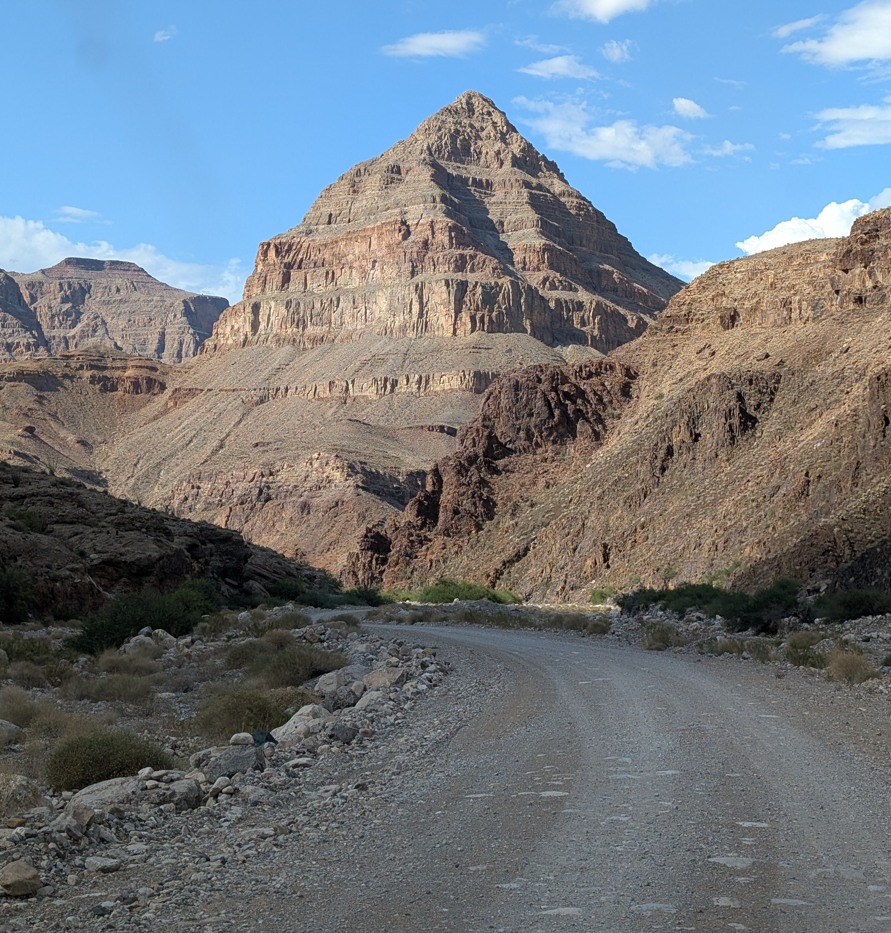
The "diamond" that gives the road its name: Diamond Peak

Without even considering the philosophical objections to building roads through the wilderness world of the Grand Canyon (objections I completely agree with), there are staggering engineering barriers. There are a series of formations, including the Redwall Limestone and the Coconino Sandstone that form sheer cliffs. The locations of trails in the Grand Canyon are controlled almost entirely by the few locations where they can surmount the cliffs of these two layers.

At Diamond Creek, the Hurricane Fault has offset the formations in just such a way that the cliffs can be avoided entirely. For the entire twenty mile length of the road, there is nary a cliff to worry about, as the road follows the bottoms of desert arroyos and washes. The biggest worry is flash floods and mudflows, which can easily shut down the road in July and August during the monsoons (and badly inconvenience river rafters who plan to take out at Diamond Creek). Unfortunately, our storm had all the hallmarks of an intense monsoon storm, and for all we knew, the road would be closed, and the whole endeavor moot. We were running late anyway, and I couldn't know the status of the road until we reached the Peach Springs office of the Game and Fish Service of the Hualapai Nation. We got there, and the sign on the door told me the worst...

All my plans dashed. But what can you do but barge your way into the office and see if the road was really closed? And it turned out that their closure was cautionary, the sign left from earlier in the day when no one had checked the road conditions. The road was okay, and I was given the permit to take our group into the canyon (the form interestingly was a permit to trespass on Hualapai land). It was the only permit given that day, and we would have the Grand Canyon to ourselves! We started down the gravel road, the Colorado River twenty miles away.

One can certainly debate the idea that it's "cheating" to drive to the bottom of the canyon, and there is a certain validity that scenery that hasn't been "earned" by completing a stiff hike might end up being less appreciated. But many people can't handle the very strenuous hiking and many simply don't have the time. Driving down into the canyon is a unique opportunity to study the oldest rocks of the canyon, the ones that are the very hardest to access in any other situation.

Diamond Creek cuts through to the Granite Gorge Metamorphic Suite, which is the oldest group of rocks found in the American Southwest, dating to as early as 1.8 billion years ago. At roadside there are marvelous exposures of schist, gneiss, and pegmatite granite with bright shiny crystals of muscovite mica and quartz.
Outcrops of schist intruded by pink pegmatite granite
A bit farther up the canyon one can see the layers of the Tonto Group, a series of three formations called the Tapeats Sandstone, the Bright Angel Shale, and the Muav Limestone. The three layers formed as the Pacific Ocean transgressed and covered much of the western North American continent in Cambrian time, just over 500 million years ago. The Tapeats Sandstone sits atop the rocks of the Granite Gorge Metamorphic Suite.
The Great Unconformity: the vertically oriented rocks in the lower half of the photo are the ancient metamorphic schist and gneiss. Above the metamorphic rocks are horizontal layers of the Tonto Group.
That last sentence needs a bit more explanation. The boundary between the Tapeats and the Granite Gorge rocks is a profound unconformity representing a gap of more than a billion years. This unconformity is actually called the "Great Unconformity", and is an erosional surface that was witness to not one, but two major mountain-building events. The metamorphic rocks were once the core of a vast mountain range that formed 1.7 billion years ago when the North American continent collided with a set of two exotic terranes, the Yavapai block and the Mazatzal block. Imagine an island the size of California or New Zealand grinding into the edge of a continent along a subduction zone and you will get the picture. This massive mountain range eroded to a flat low-relief surface over the next few hundred million years.
The Great Unconformity up close. Dark brown conglomerate of the Tonto Group rests unconformably atop the ancient metamorphic rocks.
Later on, about a billion years ago, the continent stretched and broke apart, forming a series of fault-block mountain ranges that reached heights similar to the mountains in and around Death Valley National Park today. The rocks of these mountains are exposed in the easternmost part of the Grand Canyon, but they too were eventually eroded down to a low-relief surface as well, although small  ridges a few hundred feet high persisted. Along the lower reaches of Diamond Creek Road, you can lay your hand on a boundary between two rock sequences with a gap of more than a billion years between them. The unconformity can be seen in the photo above where a conglomerate rests on contorted metamorphic rocks in the bit of shadowed ledge. The "Diamond" of Diamond Creek is the uniquely shaped peak on the left side of the photograph. It is actually a sliver of rock caught between two branches of the Hurricane fault system.

Another layer that is prominently exposed along Diamond Creek Road is the Devonian-aged Temple Butte Limestone. Most park visitors never see it because in the eastern section of Grand Canyon National Park the Temple Butte is a discontinuous thin layer that is pretty well invisible from the rim. In western Grand Canyon it is more than 700 feet thick. It formed as a tidal estuary and tidal flats along the edge of the continent about 385 million years ago.
Temple Butte cliffs in Diamond Creek
We reached the end of the road where Diamond Creek flows into the Colorado River, the watercourse responsible for carving the Grand Canyon. It was a moment for the students to cavort in the river for a few minutes, and to wonder at the work the river has done. This spot is where many of those who've rafted the river through the Grand Canyon take out, a usually raucous process, but no one was about on this particular day.
The most "mysterious" aspect of Diamond Creek and Peach Springs Canyon is that the tributary canyons to this creek follow illogical pathways, and are actually older than the Grand Canyon itself! It's an odd problem. Along the upper reaches of Peach Springs Canyon, there are a series of Paleocene to Miocene-aged rocks clinging to the canyon walls. They once filled the canyon, meaning the canyon was carved prior to sixty million years ago, and the rivers that carved it flowed northeast, opposite of the Colorado River today. Apparently the land subsided so that the canyons were filled with sediment, and then they were exhumed when the modern Grand Canyon was carved, most likely within the last four or five million years. There has been more than one Grand Canyon carved through the Colorado Plateau!
Peach Springs Canyon  (red) and the odd channels (blue) that were carved millions of years prior to the Grand Canyon itself (they were buried and exhumed when the modern canyon was carved).
Near the bottom of the road we happened upon a Bighorn Sheep. They were once more common and figured prominently in the Ancestral Pueblo petroglyphs found throughout the region. 
Diamond Creek is a fascinating excursion. It is entirely on Hualapai lands, and they charge a fee of around $17 per person for permission to drive the road. I never mind paying the fee, because the tribe doesn't have many sources of income or all that many jobs on the reservation. The town of Peach Springs where the road starts has a very nice motel and restaurant (and not much else), and if you are a train lover, you'll be able to listen to them all night long. The rails are amongst the busiest you'll ever see. The town is on one of the last remaining stretches of the original Route 66.

Our crew was ready to get to camp, so we drove an hour or so to my brother's cabin where we would spend the next three nights.
Wait a minute. Showers, kitchen, hot tub? You call this roughing it?

Saturday, December 28, 2024

About That Bucket List...What Would You Do To See These Places?

Horseshoe Bend on the Colorado River
So...about that bucket list of yours. 

Surely you have one. If you don't, what's keeping you from making one? Here's a version I promoted a few years back (I've made it to around 70% of them so far and feel exceedingly lucky to have been able to do so).

In any case, how many of the following are (or should be) on your personal list? Possibly Grand Canyon, Zion, Bryce Canyon, Arches, Petrified Forest, Capitol Reef, Yosemite, Great Basin, or Canyonlands National Parks? What about Ancestral Pueblo cliff dwellings at places like Bear's Ears or Grand Staircase-Escalante? Finding ancient petroglyphs along the Colorado River? Or searching for dinosaur bones? How would your life be changed if you could somehow do all these things...in one trip? It's possible!
Grand Canyon National Park
There is no place on this planet like the Colorado Plateau. It's hard to find anyplace else on Earth where the crust remained relatively stable for upwards of a billion years, accumulating several miles of horizontal sediments, only to be lifted up rapidly in the last few million. The Colorado River and her tributaries then stripped away much of the sedimentary cover, and cut deep into the underlying metamorphic rocks. Those metamorphic rocks record a violent geologic history of colliding landmasses and mountain-building. The resulting landscape is one of the most beautiful regions imaginable.
Angels Landing Trail in Zion National Park, Utah
The plateau country is a training ground for geologists and earth scientists, and has been since the days of John Wesley Powell and Joseph Ives, who were the first to lead research parties into the region (they didn't "discover" the plateau, of course; Native Americans have known the region for thousands of years). If you are curious about learning geology in this incredible region, you might consider joining us as a student (of any age) on our geology field studies course Geology 191: Geology of the Colorado Plateau, offered under the auspices of Modesto Junior College in Modesto, California. The course is designed to fulfil the curiosity and build the skills of lay geologists and archaeologists as well.
Mesa Arch in Canyonlands National Park
Our field course will be a grand loop through the plateau country, with investigations of the Mojave National Scenic Preserve, Grand Canyon, Zion, Bryce Canyon, Arches, Canyonlands, Petrified Forest, Capitol Reef, Great Basin and Yosemite National Parks, as well as many monuments, including Bear's Ears, Grand Staircase-Escalante, Natural Bridges, Navajo, and Hovenweep. It will be an unforgettable two week trip from June 3-17, 2025, beginning and ending in Modesto, California. Further information will be found soon here and at my school website. 
Petroglyphs on the plateau
It's not a comfortable trip...we travel in school vans (which of course are known for their luxuriousness!), we camp every night, and the days can be hot, windy, cold, or stormy, and we are out in the middle of anything that happens. But we are staying in beautiful places each night, and there are even showers and laundry available every third day or so! Extensive hiking is not required, but there will be many chances to explore the trails in each park and monument.
Petrified Forest National Park
Geology 191 is a 3-semester-unit course. By end of the course, you will be able to see the landscape the way geologists do: by identifying rocks, minerals and fossils, and interpreting the geological history of an area by working out the sequence of events as exposed in outcrops. If you are a science teacher, you will come home with a collection of photographs that illustrate most of the important principles of geology, and a selection of rocks, minerals and fossils that will make a great classroom teaching tool (legally collected, of course; there are many localities outside of protected parks from which to collect samples). You will also gain some mastery of the archaeology and culture of the plateau region, the home of the Ancestral Puebloans, the Fremont people, the Navajo, the Utes, and others.
Canyonlands National Park, Utah

The cost of the trip (still to be officially determined) will be $850 plus the cost of tuition (Currently $46 per unit for California residents, and around $225 per unit for out-of-state residents). The cost includes transportation, food, camp fees, and entrance fees. Participants would want to bring a few dollars along for showers, laundry, and souvenirs.  The food is tasty and plentiful (everyone helps cook and clean!), and the school vans...are vans.
House-on-Fire Ruin, Bear's Ears National Monument
For those of you who live in the Modesto region, we are having an organizational meeting in April which will also be available as a Zoom session. Details will be provided later on.

If you are not in the area, we will be glad to arrange for transportation from nearby airports and train stations (we actually have an Amtrak station in town). Enrollment can be completed online once you are registered with the college (http://www.mjc.edu). Please contact me with any questions you may have.
Bryce Canyon National Park
Hope to see you out there, back of beyond!

Monday, July 18, 2022

What Makes a Canyon Grand? And How Deep is Deep? Exploring Kings Canyon, One of the Deepest Canyons in North America

Well, let's jump right into it. The picture above is Spanish Peak in the Sierra Nevada, which looms above the canyon of the Kings River. The peak tops out at 10,051 feet (3,064 meters). The drainage on the left is Rough Creek, and it enters the Kings River at an elevation of about 1,800 feet. The drainage on the right is Deer Creek, and it enters the Kings at about 2,300 feet. This seems to indicate a depth of Kings Canyon as between 8,200 and 7,700 feet, depending on where you choose to define it. 

So, what of it? 

If you search for "the deepest canyon in North America", the honor seems more often to be given to Hells Canyon on the Snake River on the border between Oregon and Idaho. The depth often given is the difference between He-Devil Mountain and the river at 7,993 feet (2,436 meters). Or 8,043 feet (2,452 meters). Or 7,913 feet (2,411 meters).  

So, the designation of "deepest canyon" seems to be somewhat in conflict. The argument can be muddied by pointing out the canyons are asymmetric, and that the other sides of the canyons are less dramatic in height. There is some truth to this, as the south slope at Kings Canyon tops out at just over 7,000 feet, meaning that the canyon is only a little over 5,000 feet deep. But the problem is similar for Hells Canyon, where the ridges across the river are just over 5,000 feet above the river. 

Which is deepest? I don't know, and I don't particularly care. If Idaho needs to have the 'deepest' or 'biggest' of something, they can have it. After all California has lots of superlatives, like biggest living things, tallest trees, oldest living things, tallest mountain in the lower 48, and so on. I've not been to Hells Canyon. But I have been to Kings Canyon, and what I do know is that it is one of the most spectacular places on Earth.

The upper reaches of Kings Canyon include some of the highest and most rugged parts of the Sierra Nevada crest. Parts of the Middle Fork are too precipitous for roads or even foot trails. These parts of the canyon are protected as Kings Canyon National Park, established in 1940. a full fifty years after the designation of Yosemite as a national park. One of the most pleasant parts of the canyon, Cedar Grove, was left out of the park because of plans to inundate the valley under the waters of a reservoir. Better angels prevailed and Cedar Grove was added to the park in 1965. The downstream (and deepest) part of the canyon is administered by the U.S. Forest Service.
As rugged as the canyon is, a paved highway (Highway 180) provides access to Cedar Grove, and it is pretty incredible to drive. I marvel at the engineering decisions that went into the design of the present-day highway. The terrain is literally impassable, but someone decided where the road would go, and laborers blasted away at the rocks. Most of the construction crews were prisoners. The road was planned as early as 1905, and construction took place during the 1920s and 1930s. At one time it was envisioned that the road would continue up and over Kearsarge Pass to connect with Onion Valley. Thankfully that plan didn't come to fruition. 

The highway passes through some astounding geology. Granitic rocks may make up most of the Sierra Nevada, but Kings Canyon contains exposures of some large metamorphic roof pendants of Paleozoic and Mesozoic age. A stunning cliff of gray marble forms one wall of the South Fork, and contains a number of caverns, including the developed tourist attraction of Boyden Cavern. Quartzite, slate and spectacularly folded calc-silicate rocks are also exposed along the highway.

The viewpoints along the highway just north of Grant Grove are simply beyond compare, giving a full-on perspective of the deepest part of the gorge as well as vistas towards the high country near the Sierra Crest. And...it is a LOT less crowded than Yosemite Valley!

In case you were wondering about other deep canyons, the Sierra Nevada hosts numerous awesome gorges. The Grand Canyon of the Tuolumne River is a roadless part of Yosemite National Park which in places is fully as deep as the Grand Canyon at 5,000 feet. I would love to offer pictures, but I haven't traveled through it in many decades. Another canyon, that of the Kern River in Sequoia National Park, is 7,000 feet deep in places. Yosemite Valley is a mere 3,000 feet deep, but with those vertical walls it truly stands apart as one of the unique places of the planet.

Farther afield, Mexico has the Barranca del Cobre (Chihuahua, Mexico). The canyon system has six major gorges, of which Urique Canyon is the deepest and largest, measuring at one point 6,236 feet deep.

The deepest canyon I know of in Polynesia is Waimea Canyon on the Hawaiian Island of Kauai. It is sometimes called the "Grand Canyon of the Pacific", but I think it stands pretty well by itself without having to compare it to others. It is a favorite destination of mine when I visit the islands. It is nearly 3,000 feet deep in places.

Waimea Canyon on the island of Kauai in Hawaii

In South America, the deepest canyon I could find info on was Colca Canyon in Peru. At one point it is 13,600 feet deep. 

The ultimate canyons would pretty much have to be where the mountains are the highest, so the deepest canyon in the world is found in the Himalayas. Some of the canyons that pass through the range (the Kali Gandaki or Yarlung Tsangpo Gorges for example) are said to reach depths of 17,000-19,000 feet.

And finally, since it was part of the title, there is the Grand Canyon of Arizona. It's not the deepest canyon overall, but it does maintain a consistent depth of over 5,000 feet for several hundred miles, and there is no canyon like it in the world. I can't even describe how spectacular it is in a few sentences, so I offer the blog series I wrote after a memorable river trip in 2013 in which I almost died, twice, but also had the greatest adventure of my life. Check out Into the Great Unknown. 


Monday, March 2, 2020

Into the Great Unknown (Redux II): Journeying to my Roots, and to the Roots of Mountains

I was going over some of my old posts about my journey on the Colorado River in 2013 and came across this personal favorite, a post that discussed my own journey into geology back in 1976 during an earlier adventure of discovery in the Grand Canyon, on foot. It also included some of the most beautiful and dramatic rocks I have ever encountered. From August 30, 2013:
The photo above is my favorite self portrait from my journey down the Colorado River, into the Great Unknown. It's true that I appear in only a half dozen of my two thousand pictures from the trip, but this one captures best the sense of wonderment that I felt during the entire 227 mile long boating adventure. It was taken on one of the really special days of the trip, when we reached the ancients roots of a massive mountain range that today is long gone. It was also a day when I explored the roots of my own life adventure as a geologist and teacher.

And a day when I started to pay really close attention to the rapids on the river.

As a passenger on a raft (really, only a fool would allow me access to the oars in any rapid bigger than a riffle), we trust the boatmen. They are the ones who can quickly read and assess a rapid, either by standing up and observing just before entering, or by pulling ashore and scouting from above. They are the ones who make the snap decisions in the midst of chaos, deciding in an instant whether to pull left or right to get by the unexpected hole or pourover or eddy wall. They are the ones who keep their cool when the giant waves threaten to completely envelop the raft and sometimes tip it over (flipping is a highly undesirable outcome in a rapid; there's nothing fun about it at all). We trust them, and when they do their job really well, a passenger can actually become a bit complacent. If we've managed 40 or 50 rapids without problems, well, it can't really be that hard can it? And that's when things can get dicey.

Passengers play an important role in the run of a rapid, so we have to be paying attention as well. It's hard to imagine that pulling the oars makes any difference in the chaos of a rapid, but it does make a big one. Inches sometimes count. And when the raft threatens to flip over, the passengers have to be thinking fast enough to "highside", to fling themselves towards the rising side of the boat during a tip-over, using their weight to hopefully push the boat back towards the horizontal.

Why was I suddenly watching rapids with a renewed interest? We had reached the point on the river where John Wesley Powell was inspired to write one of his most famous passages, the one which also inspired the name of this blog series:

We are now ready to start on our way down the Great Unknown...We are three quarters of a mile in the depths of the earth...We have an unknown distance yet to run, an unknown river yet to explore. What falls there are, we know not; what rocks beset the channel, we know not; what walls rise over the river, we know not.

The next morning he adds:

At daybreak we walk down the bank of the river, on a little sandy beach, to take a view of a new feature in the canyon. Heretofore, hard rocks have given us bad river; soft rocks, smooth water; and a series of rocks harder than any we have experienced sets in. The river enters the granite!

We can see but a little way into the granite gorge, but it looks threatening.

He and the mountain men who served as his crew had already been on the the river system for two months, and with their inadequate clumsy boats had run or portaged many dozens of rapids that were terrifying. They were running very low on food (the diet: unleavened flour, dried apples and rancid bacon). And now the nature of the rocks exposed along the river promised rapids far worse than any they had encountered upstream.
Why were the rapids worse?

Indirectly, it was indeed the harder rocks. They were entering a part of the canyon composed of harder rocks than anywhere else along the river. It isn't the rocks themselves that make bad rapids, though. The river does not fall over ledges and waterfalls. Rapids on the Colorado River happen because of debris flows that enter the channel from the small tributary canyons. The debris in essence dams the river and forces the river channel to the side, making the cross-sectional area of the channel much smaller. Since the same amount of water in a river passes a given point in a given amount of time (cubic feet per second is one measure), the river must speed up to pass the barrier. You can see this effect in the picture above in Nevill's Rapid.

The severity of a rapid is determined by the volume and size of the boulders in the debris flows, and canyons cut into harder rocks produce larger boulders. Sprinkling a few giant boulders throughout a rapid turns a riffle into a terrifying roller coaster ride.
So that was the day we were facing. We would be entering the Granite Gorge of the Grand Canyon for the first time, and we would now need to run a gauntlet of the biggest rapids to be found on the entire river. It started with Hance (8 on a scale of 10), Sockdolager (7), and Grapevine (7). The next day would include Horn Creek (9). The day after that, Granite (8), Hermit (8), and the ultimate rapid, Crystal (10). These would be followed the same day by the seven rapids of the gemstones (Agate, Sapphire, Turquoise, Emerald, Ruby and Serpentine, ranging from 5 to 7). And 70 miles downstream (with plenty more rapids in-between) Lava Falls (10) awaited our arrival.
We came around a bend in the river, and I encountered a familiar sight in the midst of the Great Unknown. I had been here before! Not on a river rafting expedition, but on a backpacking trip in 1976. It had been one of the most important events in my young life, because it was the trip that set me on the road to becoming a geologist and teacher.

Geology of the Grand Canyon was actually one of the more difficult courses I had ever taken because not only did we need to master a lot of geology in a short time, but we also had to prepare for a challenging backpack down and then back up a series of officially unmaintained trails in the canyon (the New Hance and Grandview trails). The co-requisite for the class was a 2 unit physical education course in backcountry camping that including an entirely separate shakedown trip in the mountains of Southern California. When I came out of the Grand Canyon six days later I knew what I wanted to do with my life.

Of course, a few things have changed since 1976. Geotripper weighs, um, a lot more than that gawky teenager on the right in the picture below. Picture quality has improved, not so much because of better photographers, but it used to be expensive to take and develop pictures, so we never took very many. Plus we were using the old Kodak Instamatic cameras or something similar.

Still, seeing these pictures a few years ago on Facebook (thanks to J. Elson) brought a shock of memories, and now for the first time in forty years I was once again standing at the rapid that made a geologist out of me.
Only this time my mind was on other things. Back then when we finished, we turned around and started hiking back out of the canyon.
We were about to run a major Grand Canyon rapid in boats that suddenly seemed really small. Just like these river rafters in 1976. I noticed that the two biggest boulders haven't moved, and that the rapid was as chaotic looking as ever.

We had reached the base of the Grand Canyon Supergroup, and could now see the three formations that make up the oldest units: the Shinumo Quartzite, the bright red Hakatai Shale, and the basal Bass Limestone (intruded by basaltic dikes). The rocks are tilted about 15 degrees, giving the illusion that the river gradient is even steeper than it already seems. It can't have been a comforting sight to Powell and his men in 1869.

The Grand Canyon Supergroup sits on a mountain range of Andean proportions. Or more properly stated, the layers were deposited on the low erosional plain left behind when a mountain range of Andean proportions was completely washed away. The black schists and reddish granite intrusions once lay some five miles deep in the crust, and now they have been laid bare by the cutting of the Grand Canyon.

The rocks today are called the Granite Gorge Metamorphic Suite, and they formed in a series of collisions between a group of volcanic islands (called terranes), and the ancient North American continent around 1.7 billion years ago. The metamorphic schist and gness units were intruded by granitic magmas at intervals between 1.7 and 1.4 billion years ago. And now those rocks are exposed in the very deepest part of the Grand Canyon.
We successfully negotiated Hance Rapid (not without getting positively soaked), and looking back upstream, I could see the basalt dike that I had found so utterly fascinating on my first trip into the canyon.
The canyon was dark, but I did not feel as sense of brooding. I was exhilarated, my imagination seeing the peaks and canyons that must have existed here in the distant past, mountain slopes which would have been utterly lifeless and barren. Deep gorges must have been cut by rushing rivers that were never seen by any living thing. Entire Grand Canyons could have been carved here and we will never know of their existence. We now entered a fascinating world of exceedingly rugged vertical canyon walls. The silt and sand polished the hard granite and metamorphic rock.

Sockdolager Rapid (the word is an archaic term for knockout blow in boxing) was a fun ride, nothing like the terror-filled lining and portage in Powell's writings.

It was hard to find a spot to scout, so the boatmen checked out the rapid by standing up as they approached.
Between rapids the river was calm, and the canyon walls rose straight from the water.
The metamorphic suite was composed of the most diverse and beautiful rocks that I had seen anywhere on the trip. The polishing simply added to the beautiful sculpted appearance of the rock.
We arrived at camp in Cremation Canyon by 2:30. We had pulled in early because we would be saying goodbye to three of our fellow travelers who would be hiking out of the canyon from Phantom Ranch, and meeting three others who would take their place for the remainder of our journey.

I turned in early once again...tomorrow we faced the biggest rapids so far on the trip.