Showing posts with label The Great Unconformity. Show all posts

Monday, June 23, 2025

Journeys in the Back of Beyond: Simply Driving to the Bottom of the Grand Canyon (!?)


Running a geology field studies course is nothing if not stressful. Right on the heels of the most intense storm I've experienced on one of these trips, it was morning and we were on the road to the next thing. A simple thing really, just driving down to the bottom of the Grand Canyon. But I had no way of knowing it would happen, given the storms of the previous night. Had the storm affected the road into the canyon?
 
The Grand Canyon is one of the great spectacles of the Earth. Millions of people every year stand on the edge of the abyss and peer in, taking in the vivid colors and hidden depths. Tens of thousands venture down some of the few trails that reach into the incredible gorge, and several thousand raft the river. But how many drive the canyon? Did you even know you could?
And no, I'm not talking about visiting the canyon "Thelma and Louise" style...

For more than two hundred river miles, no road crosses the Grand Canyon (plus another hundred miles along the shores of Lake Mead). Navajo Bridge near Lee's Ferry is at one end, and Pat Tilman Bridge near Hoover Dam is at the other. In between in the depths of Grand Canyon there is a single road that reaches the river. It's called Diamond Creek Road, and it starts on Hualapai Nation land at Peach Springs, Arizona. It's a marvelous adventure.
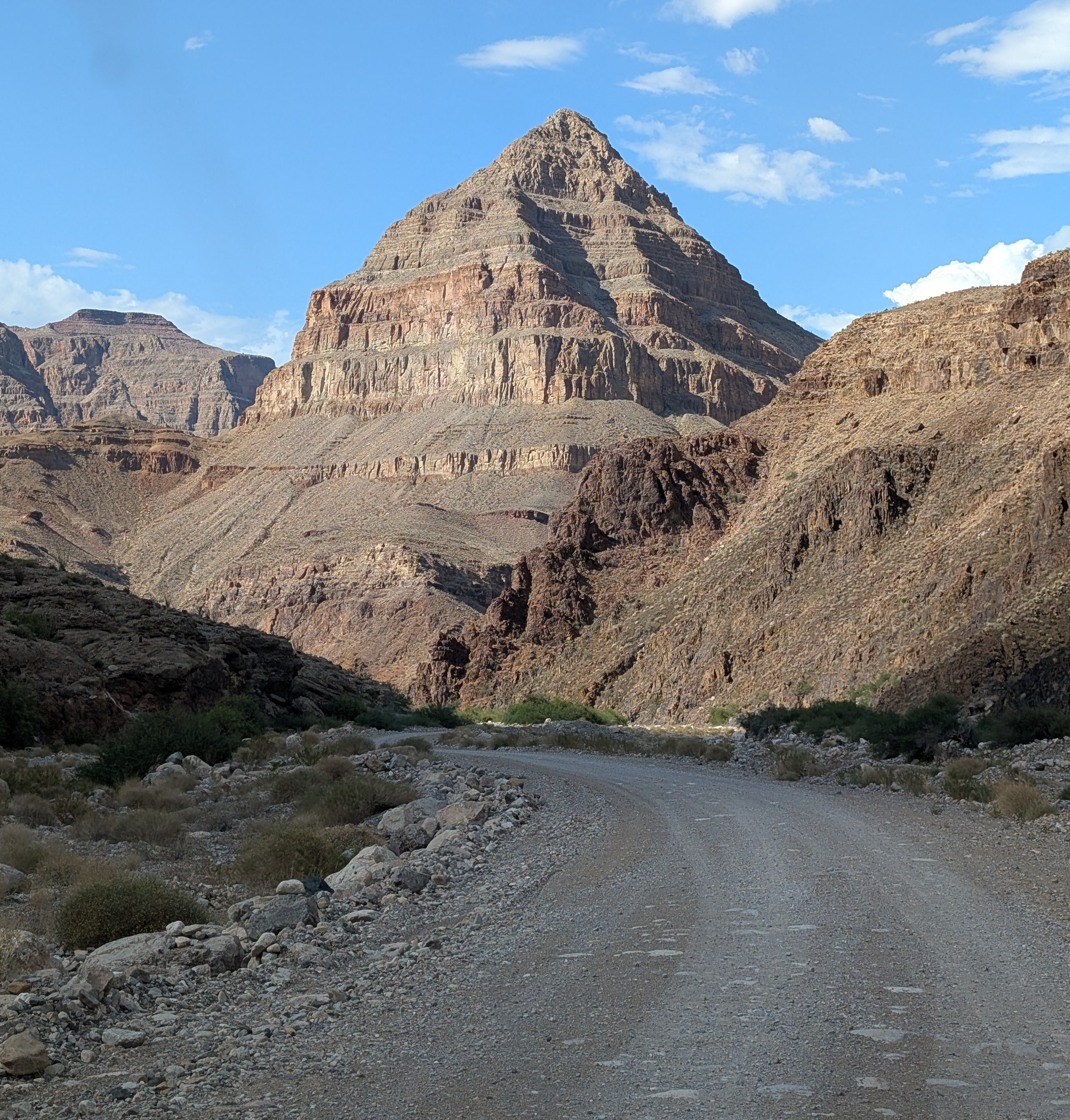
The "diamond" that gives the road its name: Diamond Peak

Without even considering the philosophical objections to building roads through the wilderness world of the Grand Canyon (objections I completely agree with), there are staggering engineering barriers. There are a series of formations, including the Redwall Limestone and the Coconino Sandstone that form sheer cliffs. The locations of trails in the Grand Canyon are controlled almost entirely by the few locations where they can surmount the cliffs of these two layers.

At Diamond Creek, the Hurricane Fault has offset the formations in just such a way that the cliffs can be avoided entirely. For the entire twenty mile length of the road, there is nary a cliff to worry about, as the road follows the bottoms of desert arroyos and washes. The biggest worry is flash floods and mudflows, which can easily shut down the road in July and August during the monsoons (and badly inconvenience river rafters who plan to take out at Diamond Creek). Unfortunately, our storm had all the hallmarks of an intense monsoon storm, and for all we knew, the road would be closed, and the whole endeavor moot. We were running late anyway, and I couldn't know the status of the road until we reached the Peach Springs office of the Game and Fish Service of the Hualapai Nation. We got there, and the sign on the door told me the worst...

All my plans dashed. But what can you do but barge your way into the office and see if the road was really closed? And it turned out that their closure was cautionary, the sign left from earlier in the day when no one had checked the road conditions. The road was okay, and I was given the permit to take our group into the canyon (the form interestingly was a permit to trespass on Hualapai land). It was the only permit given that day, and we would have the Grand Canyon to ourselves! We started down the gravel road, the Colorado River twenty miles away.

One can certainly debate the idea that it's "cheating" to drive to the bottom of the canyon, and there is a certain validity that scenery that hasn't been "earned" by completing a stiff hike might end up being less appreciated. But many people can't handle the very strenuous hiking and many simply don't have the time. Driving down into the canyon is a unique opportunity to study the oldest rocks of the canyon, the ones that are the very hardest to access in any other situation.

Diamond Creek cuts through to the Granite Gorge Metamorphic Suite, which is the oldest group of rocks found in the American Southwest, dating to as early as 1.8 billion years ago. At roadside there are marvelous exposures of schist, gneiss, and pegmatite granite with bright shiny crystals of muscovite mica and quartz.
Outcrops of schist intruded by pink pegmatite granite
A bit farther up the canyon one can see the layers of the Tonto Group, a series of three formations called the Tapeats Sandstone, the Bright Angel Shale, and the Muav Limestone. The three layers formed as the Pacific Ocean transgressed and covered much of the western North American continent in Cambrian time, just over 500 million years ago. The Tapeats Sandstone sits atop the rocks of the Granite Gorge Metamorphic Suite.
The Great Unconformity: the vertically oriented rocks in the lower half of the photo are the ancient metamorphic schist and gneiss. Above the metamorphic rocks are horizontal layers of the Tonto Group.
That last sentence needs a bit more explanation. The boundary between the Tapeats and the Granite Gorge rocks is a profound unconformity representing a gap of more than a billion years. This unconformity is actually called the "Great Unconformity", and is an erosional surface that was witness to not one, but two major mountain-building events. The metamorphic rocks were once the core of a vast mountain range that formed 1.7 billion years ago when the North American continent collided with a set of two exotic terranes, the Yavapai block and the Mazatzal block. Imagine an island the size of California or New Zealand grinding into the edge of a continent along a subduction zone and you will get the picture. This massive mountain range eroded to a flat low-relief surface over the next few hundred million years.
The Great Unconformity up close. Dark brown conglomerate of the Tonto Group rests unconformably atop the ancient metamorphic rocks.
Later on, about a billion years ago, the continent stretched and broke apart, forming a series of fault-block mountain ranges that reached heights similar to the mountains in and around Death Valley National Park today. The rocks of these mountains are exposed in the easternmost part of the Grand Canyon, but they too were eventually eroded down to a low-relief surface as well, although small  ridges a few hundred feet high persisted. Along the lower reaches of Diamond Creek Road, you can lay your hand on a boundary between two rock sequences with a gap of more than a billion years between them. The unconformity can be seen in the photo above where a conglomerate rests on contorted metamorphic rocks in the bit of shadowed ledge. The "Diamond" of Diamond Creek is the uniquely shaped peak on the left side of the photograph. It is actually a sliver of rock caught between two branches of the Hurricane fault system.

Another layer that is prominently exposed along Diamond Creek Road is the Devonian-aged Temple Butte Limestone. Most park visitors never see it because in the eastern section of Grand Canyon National Park the Temple Butte is a discontinuous thin layer that is pretty well invisible from the rim. In western Grand Canyon it is more than 700 feet thick. It formed as a tidal estuary and tidal flats along the edge of the continent about 385 million years ago.
Temple Butte cliffs in Diamond Creek
We reached the end of the road where Diamond Creek flows into the Colorado River, the watercourse responsible for carving the Grand Canyon. It was a moment for the students to cavort in the river for a few minutes, and to wonder at the work the river has done. This spot is where many of those who've rafted the river through the Grand Canyon take out, a usually raucous process, but no one was about on this particular day.
The most "mysterious" aspect of Diamond Creek and Peach Springs Canyon is that the tributary canyons to this creek follow illogical pathways, and are actually older than the Grand Canyon itself! It's an odd problem. Along the upper reaches of Peach Springs Canyon, there are a series of Paleocene to Miocene-aged rocks clinging to the canyon walls. They once filled the canyon, meaning the canyon was carved prior to sixty million years ago, and the rivers that carved it flowed northeast, opposite of the Colorado River today. Apparently the land subsided so that the canyons were filled with sediment, and then they were exhumed when the modern Grand Canyon was carved, most likely within the last four or five million years. There has been more than one Grand Canyon carved through the Colorado Plateau!
Peach Springs Canyon  (red) and the odd channels (blue) that were carved millions of years prior to the Grand Canyon itself (they were buried and exhumed when the modern canyon was carved).
Near the bottom of the road we happened upon a Bighorn Sheep. They were once more common and figured prominently in the Ancestral Pueblo petroglyphs found throughout the region. 
Diamond Creek is a fascinating excursion. It is entirely on Hualapai lands, and they charge a fee of around $17 per person for permission to drive the road. I never mind paying the fee, because the tribe doesn't have many sources of income or all that many jobs on the reservation. The town of Peach Springs where the road starts has a very nice motel and restaurant (and not much else), and if you are a train lover, you'll be able to listen to them all night long. The rails are amongst the busiest you'll ever see. The town is on one of the last remaining stretches of the original Route 66.

Our crew was ready to get to camp, so we drove an hour or so to my brother's cabin where we would spend the next three nights.
Wait a minute. Showers, kitchen, hot tub? You call this roughing it?

Sunday, June 8, 2014

Exploring the Depths of the Grand Canyon...By Car?

The Grand Canyon is one of the great spectacles of the Earth. Millions of people every year stand on the edge of the abyss and peer in, taking in the vivid colors and hidden depths. Tens of thousands venture down some of the few trails that reach into the incredible gorge, and several thousand raft the river. But how many drive the canyon? Did you even know you could?
And no, I'm not talking about visiting the canyon "Thelma and Louise" style...

For more than two hundred river miles, no road crosses the Grand Canyon (plus another hundred miles to Lake Mead). Navajo Bridge near Lee's Ferry is at one end, and Pat Tilman Bridge near Lake Mead is at the other. In between in the depths of Grand Canyon there is a single road that reaches the river. It's called Diamond Creek Road, and it starts on Hualapai Nation lands at Peach Springs. It's a marvelous adventure.

Without even considering the philosophical objections to building roads through the wilderness world of the Grand Canyon (objections I completely agree with), there are staggering engineering barriers. There are a series of formations, including the Redwall Limestone and the Coconino Sandstone that form sheer cliffs. The locations of trails in the Grand Canyon are controlled almost entirely by the few locations where they can surmount the cliffs of these two layers.

At Diamond Creek, the Hurricane Fault has offset the formations in just such a way that the cliffs can be avoided entirely. For the entire twenty mile length of the road, there is nary a cliff to worry about, as the road follows the bottoms of desert arroyos and washes. The biggest worry is flash floods and mudflows, which can easily shut down the road in July and August during the monsoons (and badly inconvenience river rafters who plan to take out at Diamond Creek).
One can certainly discuss the idea that it's "cheating" to drive to the bottom of the canyon, and there is a certain validity that scenery that hasn't been "earned" by completing a stiff hike might end up being less appreciated. But many people can't handle the very strenuous hiking and many simply don't have the time. Driving down into the canyon is a unique opportunity to study the oldest rocks of the canyon, the ones that are the very hardest to access in any other situation.
Diamond Creek cuts through to the Granite Gorge Metamorphic Suite, which is the oldest group of rocks found in the American Southwest, dating to as early as 1.8 billion years ago. At roadside there are marvelous exposures of schist, gneiss, and pegmatite granite with bright shiny crystals of muscovite mica and quartz.
A bit farther up the canyon one can see the layers of the Tonto Group, a series of three formations called the Tapeats Sandstone, the Bright Angel Shale, and the Muav Limestone. The three layers formed as the Pacific Ocean transgressed and covered much of the western North American continent in Cambrian time, just over 500 million years ago. The Tapeats Sandstone sits atop the rocks of the Granite Gorge Metamorphic Suite.

That last sentence needs a bit more explanation. The boundary between the Tapeats and the Granite Gorge rocks is a profound unconformity representing a gap of more than a billion years. This unconformity is actually called the "Great Unconformity", and is an erosional surface that was witness to not one, but two major mountain-building events. The metamorphic rocks were once the core of a vast mountain range that formed 1.7 billion years ago when the North American continent collided with a set of two exotic terranes, the Yavapai block and the Mazatzal block. Imagine an island the size of California or New Zealand grinding into the edge of a continent along a subduction zone and you will get the picture. This massive mountain range eroded to a flat low-relief surface over the next few hundred million years.
Later on, about a billion years ago, the continent stretched and broke apart, forming a series of fault-block mountain ranges that reached heights similar to the mountains in and around Death Valley National Park today. The rocks of these mountains are exposed in the easternmost part of the Grand Canyon, but they too were eventually eroded down to a low-relief surface as well, although small  ridges a few hundred feet high persisted. Along the lower reaches of Diamond Creek Road, you can lay your hand on a boundary between two rock sequences with a gap of more than a billion years between them. The unconformity can be seen in the photo above where a conglomerate rests on contorted metamorphic rocks in the bit of shadowed ledge. The "Diamond" of Diamond Creek is the uniquely shaped peak on the left side of the photograph. It is actually a sliver of rock caught between two branches of the Hurricane fault system.
Another layer that is prominently exposed along Diamond Creek Road is Devonian-aged Temple Butte Limestone. Most park visitors never see it because in the eastern section of Grand Canyon National Park the Temple Butte is a discontinuous thin layer that is pretty well invisible from the rim. In western Grand Canyon it is more than 700 feet thick. It formed as a tidal estuary and tidal flats along the edge of the continent about 385 million years ago.
The most "mysterious" aspect of Diamond Creek and Peach Springs Canyon is that the tributary canyons to this creek are older than the Grand Canyon itself. It's an odd problem. Along the upper reaches of Peach Springs Canyon, there are a series of Paleocene to Miocene-aged rocks clinging to the canyon walls. They once filled the canyon, meaning the canyon was carved prior to sixty million years ago, and the rivers that carved it flowed northeast, opposite of the Colorado River today. Apparently the land subsided so that the canyons were filled with sediment, and then they were exhumed when the modern Grand Canyon was carved, most likely within the last four or five million years.
Photo by Mrs. Geotripper

Diamond Creek is a fascinating excursion. It is entirely on Hualapai lands, and they charge a fee of around $25 per person for permission to drive the road. I never mind paying the fee, because the tribe doesn't have many sources of income or all that many jobs on the reservation. The town of Peach Springs where the road starts has a very nice motel and restaurant (and not much else), and if you are a train lover, you'll be able to listen to them all night long. The rails are amongst the busiest you'll ever see.The town is on one of the last remaining stretches of the original Route 66.

Friday, July 5, 2013

Out in America's Never Never: Exploring the Grand Canyon...in Las Vegas?

Photo by Mrs. Geotripper

I'm sure no one needs to be told that visiting Las Vegas is a surreal experience. I can't even begin to imagine the army of psychologists who through the years have advised casino owners on the best ways to separate tourists from their money. I've been appalled at the... well, I can't come up with any term better than excess. Las Vegas serves as a fine definition of the word.

I wonder what the point is of seeing the canals of Venice, a circus, New York, and the Egyptian pyramids when one could presumably see the real thing? One of my stranger experiences was the time I left the South Rim of Grand Canyon and arrived at a casino decorated as...the Grand Canyon. Complete with animatronic deer and raccoons. And plastic pine trees.

And yet, strangely enough, one can explore the Grand Canyon in Las Vegas, at least in one sense, and more easily than one can in the National Park. Our journey through the American Never Never took us from the Mojave National Preserve to Sin City because of the access it provides to the Proterozoic and Early Paleozoic rocks that in the park are only found deep in the canyon at the end of a hugely strenuous hike.
Photo by Mrs. Geotripper

Frenchman Mountain rises east of the city, at the boundary between the city limits and the Lake Mead National Recreation Area. The mountain mostly falls under the jurisdiction of the Bureau of Land Management, which for decades let the land languish as a shooting gallery and trash dump. Geologists have known for years (especially since the 1960s publication of John Shelton's Geology Illustrated) that the rocks exposed on the flanks of the mountain were the same as the formations found in the deepest part of the Grand Canyon. One can easily lay one's hand across 1.2 billion years of geologic history at the exposure of the Great Unconformity (it's at my feet in the picture above, sloping up to the right). One can see the cross-bedded sandstones of the Cambrian Tapeats Formation, the remains of a shallow sea that transgressed across the western margin of the North American continent. And in the small canyon above these exposures, one can pick out trails, burrows and the discarded carapaces of some of the earliest complex life forms to be found on our planet, from the Bright Angel Shale.

It is an interesting story just explaining how rocks of the Grand Canyon came to be exposed here in the Las Vegas Valley. In short, the rocks were transported 50 miles westward by extreme extensional faulting in Miocene time, around 23 to 6 million years ago. A major detachment fault system is presumed to underly the region (below).
Source: Stephen Rowland, UNLV


It's an important and significant geologic locality, one that would be worthy of an interpretive sign and trail. In the 1990s, students and volunteers associated with the University of Nevada, Las Vegas put in a tremendous amount of work to construct such a site. It was very nicely done, with a brick walkway, sturdy interpretive signs, and a short nature trail.
This was the roadside interpretive sign that explained the value of the site (source: Stephen Rowland, UNLV)

But no good deed goes unpunished. The site was in place by 2001, and within a few short years it was completely obliterated by vandals. It sickens me beyond words that such people exist who feel compelled to destroy the good works of others.

Still, it is a great place to visit and learn a bit of geology. The signs are gone, but so is most of the trash and garbage, and a walk up the hill provides a stunning view of the most unlikely city in existence. Download the information from the UNLV website at http://geoscience.unlv.edu/pub/rowland/Virtual/virtualfm.html and you won't need the signs anyway.

Next time you find yourself in the city of casinos, here is something you can do that doesn't remove money from your pocket! Check it out...it's at the end of Lake Mead Boulevard in the northeastern part of the city on the way to Lake Mead.

Friday, July 13, 2012

The Abandoned Lands...A Journey Through the Colorado Plateau: Three Grand Canyons in one

The Grand Canyon is one of those extraordinary places that becomes even more extraordinary the more you look at it. Just about everyone has seen pictures of the place and understands on some elementary level that the cliffs and slopes within the canyon reveal some sort of story about the Earth's history. Interpretive signs at the park go to great lengths to describe the shallow seas, river floodplains, and desert sand dunes that formed the colorful canyon walls. What gets less press is the fact that the most visible part of the Grand Canyon, the Paleozoic-aged horizontal layers, tells a rather limited story. It is true that the Paleozoic era was pivotal in the history of life on this planet, with the origin of complex life, the first fish, the first amphibians, the first reptiles, and the beginning of the dominance of insects and other arthropod species that continues to this day. But the Paleozoic era only encompasses around 300 million years, from 542 million to 251 million years ago, out of an Earth history that spans 4.6 billion years.

And there are even huge chunks of time missing from the Paleozoic layers that are present in the Canyon. The Cambrian is represented by three formations (the Tapeats, Bright Angel and Muav formations), but rocks of the Ordovician and Silurian periods are missing entirely. The Devonian period is represented by a single discontinuous layer, the Temple Butte, as is the Mississippian (by the prominent Redwall Limestone). The Pennsylvanian and Permian periods are recalled by the Supai Group, the Hermit formation, the Coconino Sandstone, the Toroweap formation, and the Kaibab formation, which forms the rimrock of the Grand Canyon. All told, there are about 4,000 feet of Paleozoic rocks in the Grand Canyon. A patchy record, albeit very scenic and dramatic.

Of course, the horizontal layers aren't the whole story. I wrote an earlier post about the ancient rocks of the Inner Canyon, the gneiss, schist and granite of a long-gone and never seen mountain range that formed 1.7 billion years ago. We were able to see these rocks on our journey down Peach Springs Canyon and Diamond Creek and we were able to lay our hands on the Great Unconformity that divides the older rocks from the Cambrian sediments. But the Grand Canyon has other secrets hidden in its depths, and they aren't as easy to access. But you can spot them from the rim in the right places.
There are three more Grand Canyons down there. Not as in deep canyons, but as in the thickness of the sedimentary rocks. The Grand Canyon Supergroup has an aggregate thickness of 12,000 feet, more than three times that of the more familiar Paleozoic sediments. And they represent a lot more time, around 500 million years.

500 million years is a long time. The last 500 million years or so of history include all the Paleozoic events mentioned above, but also the rise and fall of the dinosaurs, and the rise of the mammals, the birds, and of course at the very end, humans. The rocks in the Grand Canyon Supergroup encompass the period from 1.2 billion years to around 700 million years ago.
How do you fit 12,000 feet of sedimentary rocks into a canyon only (only!) 5,000 feet deep? You tilt them! And the tilting event hints at an even more extraordinary story: there is another mountain range that existed here, a mountain range that is almost entirely gone, and like the earlier range was never seen by sentient beings. Eyes had not yet evolved in the world, and neither had life emerged on the land (and the seas held only unicellular life forms).

The story goes something like this: after the Mazatzal Mountains of 1.7 billion years ago wore away, they left behind an essentially flat surface near sea level. As a result of lands sinking, or sea levels rising, this surface was inundated under shallow seas for a time, and covered by river floodplains at other times. Intrusions of basaltic rock sometimes erupted at the surface, producing thick lava flows (the Cardenas Lavas, the black layer in the picture above). In late Proterozoic time, many of the continents were massed together in a percursor supercontinent to the better-known Pangaea: Rodinia. Rodinia was beginning to fall apart at the seams, and faults formed around rift valleys. The rocks of the supergroup rose and were tilted into a series of mountains and valleys not unlike the Basin and Range province of today. The mountains rose thousands of feet into the air, and erosion tore at their flanks. Eventually nothing was left but low ridges a few hundred feet high. The continent split completely and a large landmass that included Australia and Antarctica rifted away from western North America. The continental edges subsided and the sea started to transgress across the region in Cambrian time. The flatlands were covered with beach sands and the ridges persisted as islands for a time until they too were submerged (one of those islands is visible in the picture below where the cliff of purplish Shinumo Quartzite and magenta Hakatai Shale pierce the overlying Bright Angel Shale).
The only way to see the rocks of the Grand Canyon Supergroup up close is to hike to the bottom of the Grand Canyon. Seeing them up close on my first geology field trip in 1976 was a pivotal event in my life: many hard to understand principles clicked into place during that journey. The rocks can be observed quite well from viewpoints in the eastern part of the South Rim, especially Desert View, Lipan and Moran Points. Samples of the rocks of the many formations of the Supergroup can be viewed along the "Trail of Time" that extends from Yavapai Point to Verkamps Visitor Center on the South Rim. A picture of some algal stromatolites, one of the few kinds fossils found in the Supergroup, is shown below.
In an odd way, the Grand Canyon Supergroup played a role in making the canyon livable for humans. The easily eroded rocks of some the layers produced some flat areas deep in the canyon at Unkar Delta. This allowed soils to develop and made agriculture possible, so a village was built down there a thousand years ago.
Three Grand Canyon sequences in one. Two mountain systems hidden in the depths of the canyon. Profound unconformities. I love teaching about geology when I am here. I was obviously enthusiastic last month when I was lecturing my poor overheated students. They were polite enough, but a number of tourists gathered while I was talking, and afterwards they had lots of questions!

Tuesday, January 3, 2012

The Delightful Details: Why I love the Grand Canyon

As my readers may know, I made it to the Grand Canyon as my last trip of 2011 where I saw a nice sunset, and a glorious sunrise. It's kind of a yearly tradition to stop at the canyon, as several family members live near by (in the southwest, 200 miles is 'near'; if you get that close, it is worth the diversion!). There are many things to love about a place like the Grand Canyon. For me, on this trip, it was the details. I don't think I had walked out to Powell Point in past visits, but it looks to be one of my favorite South Rim stops now. The point juts out well into the canyon, and the short trail has steep drop-offs on both sides. The view extends a great distance both east and west. It's easy to get lost in the grandeur of the view. This time I was looking closer, at some of the details. In the picture above, look at the center-right, in the deepest part of the canyon. See if you can pick out where I zoomed in on the picture below.
I zoomed closer, and concentrated on the scene below. It was a familiar one for me, as it is repeated many times in the Grand Canyon, as well as several other spots around the southwest. There are two main elements here, a light brown layer of sandstone on the top, about 200 feet thick, and a sheer cliff below made up of metamorphic rock and granitic intrusions. The story told in these rocks is part of what led me into geology; I walked across a surface like this during my first geology field trip in 1976 and was duly impressed. I wanted to know more.
 
The contact between the two rock sequences is a nonconformity, an erosional boundary between two contrasting rock types. Many people who see the Grand Canyon for the first time might think that the rocks represent some sort of continuous record of deposition, a complete encyclopedia of earth history. This couldn't be further from the truth. The succession of rocks in the Grand Canyon has been interrupted many times by uplift and erosion, and huge gaps occur in the sequence. There are more rocks missing than there are present. The gap shown in the picture above spans something like a billion years!

The sedimentary rock is called the Tapeats Sandstone. It is typical of the kind of sand that might accumulate along a shoreline, although in this case, the beach existed 525 million years ago. It would have been a strange environment to those of us in the world today...there was no life on land, just barren rock and sediment. There was life in the sea, but few species that would be familiar to us. The fossils most commonly found are trilobites, arthropods that are vaguely similar to pillbugs and horseshoe crabs. There were sponges, and some brachiopods (lampshells), and many strange and wonderful soft-bodied creatures who left little in the way of a fossil record (google 'Burgess Shale' if you want to know what they looked like).
The rock beneath is exceedingly complex, and a complete understanding of its origin is still to be determined by further research. We have discovered enough evidence to tell a dramatic story that included deposition of sediments and lavas on a sea floor around two billion years ago, the subsequent crushing and deformation of those rocks, and their rise from the deep crust to form the core of a gigantic mountain range around 1.8 to 1.7 billion years ago. This was followed by intense erosion for hundreds of millions of years, and then renewed mountain-building activity around a billion years ago. These mountains were also worn away until a nearly flat surface remained, interrupted here and there by low hills and ridges of resistant rock.

Then the land slowly sank, and sea transgressed across the landscape. The beach sands of the Tapeats buried all but the highest of the hills, which projected as modest islands. They weren't completely inundated until several tens of millions of years later. That's what I found incredible about the Grand Canyon on my first trip all those years ago. When you know what to look for, you can see these islands exposed in the canyon walls.

Many years ago, the first geologists to explore the secrets of the Grand Canyon called this "The Great Unconformity". I agree...
I place my hand on a billion year gap in time at Frenchman Mountain near Las Vegas. This is the same unconformity as the one seen in the deepest part of Grand Canyon

The rock samples pictured above are to be found along the Trail of Time between Verkamps Visitor Center and Yavapai Point on the South Rim, a recently completed exhibit. The sponsors and innovators did a great job of bringing alive the concept of geologic time.