Showing posts with label Angular unconformity. Show all posts

Thursday, July 5, 2018

Home from Back of Beyond: Images of a Harsh Country, Part Two

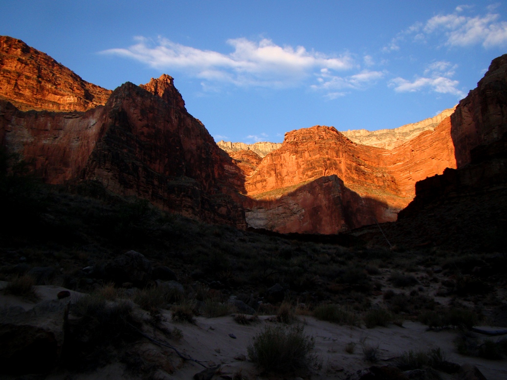
The photo above encompasses so much of what captivates me about the southwestern United States. A trail formed from a natural weakness in the rock providing access to an otherwise inaccessible cliff to who knows where? To be fair, hundreds of thousands of people know where the trail leads, but I like the mystery of the image. The thing is, many people DO follow this trail every year, but they may not appreciate the fact that the last time this surface was exposed to the atmosphere, it was 200 million years ago, and on the slip face of a coastal dune. Some of the irregularities highlighted by the shadows in the picture could literally be the preserved footsteps of dinosaurs, other reptiles, or amphibians.

I am slowly working on a short series of posts with my favorite images from our recently completed exploration of the Colorado Plateau and surrounding provinces. I took 1,400 photographs, so it's a bit difficult to choose between them! As we pick up the narrative, we are eight days into a fifteen day trip. As seen in an earlier post, we'd already been to the Mojave National Preserve, Zion National Park, Grand Canyon National Park, Bear's Ears National Monument, and Mesa Verde National Park. As we left Mesa Verde, we needed to find a way over the San Juan Mountains, a major range within the Rocky Mountain chain.
Because of a major wildfire in the drainage of the Animas River above Durango, we had to find another route over the mountains, so we headed instead to Lizard Head Pass (10,222 feet/3,116 meters), which divides the drainage of the Dolores and San Miguel Rivers. There was a beautiful profile of the high peaks from the summit. The brightly colored rocks above the tree line are volcanic, part of the rhyolite caldera eruptions that were taking place around 35-30 million years ago. Mineralization related to the volcanic activity resulted the emplacement of gold and silver deposits. The old mining towns like Ouray and Telluride are picturesque, but the pollution relating to the mining is a sad heritage.
Near the town of Ouray, one of the old mining camps, there is a difficult-to-see waterfall called Box Canyon Falls. The 200 foot high falls are practically hidden in a deep slot canyon, but the slopes above reveal a spectacular angular unconformity. The underlying vertical layers are more than a billion years old, but erosion planed off the rocks and in Devonian time almost 400 million years ago new sediments were draped over the older rocks. The uplift of the San Juan Mountains caused further erosion, exposing the unconformity that represents almost a billion years of missing history.
Black Canyon of the Gunnison is possibly the most bizarre canyon on the continent. It is a nearly vertical gorge that cuts through what is essentially the top of a mountain instead of having been carved through softer rocks that are exposed nearby. The Gunnison River was forced into the present channel by a series of lava flows that diverted the river from a "normal" course. Around 2-3 million years ago the landscape was uplifted, and the trapped river cut down through all the rock in its path, including the extremely hard gneiss and granite that make up the canyon walls in the park. It's not the deepest canyon in the country, but no other canyon combines the depth and steepness of Black Canyon. It is more than 2,000 feet deep in places, and in one place it is only 1,100 feet wide.
The Painted Wall (above) in Black Canyon is the highest sheer cliff in Colorado at 2,250 feet. The rocks exposed in the face of the cliff include 1.7 billion year old gneiss and schist with numerous intrusions and dikes of lighter colored granitic rock, including extremely coarse-grained pegmatite.
Late in the day we headed down one of the most spectacular roads in North America, Highway 128, which follows the Colorado River from near Interstate 70 to the outskirts of Moab, Utah. While mostly confined to a deep and narrow gorge of sandstone cliffs along the river, there is a moment when the canyon opens up and there is an awe-inspiring view of the Fisher Towers and the La Sal Mountains.

The La Sal Mountains are an anomaly in the generally horizonal landscapes of the Colorado Plateau. Between 28 and 25 million years ago, plumes of magma worked their way almost to the surface, intruding laterally between the sedimentary layers, and causing them to swell upwards like a series of blisters in the crust. The intrusions are called laccoliths. Exposed now by erosion, the igneous rocks reach elevations of almost 13,000 feet.
We arrived at our campsite in Arches National Park as the sun approached the western horizon. I don't think there is a more spectacular place in the country to roll out a sleeping bag. The view from the group camp extends for miles in every direction. There is also a beautiful arch, Skyline, visible from camp (below). The arch more than doubled in size in 1940 when a huge chunk of rock fell from the opening.

The landscapes in and around Arches and Canyonlands National Parks are almost beyond description. We spent two days in the area, and one of our stops was a rock art panel that is so delicate and fragile that I can't believe that it still exists 30 years after I first discovered it. Why? It's easily seen from the paved road leading into Canyonlands. But without signs and arrows pointing the way, people miss it. The first of the images are pictographs (below), those examples of rock art that were painted onto the sandstone. The ghostly figures and small hummingbirds are almost nightmarish in their imagery.
The other images are petroglyphs, the ones carved directly from the rocks. They depict some stylized bighorn sheep and other creatures. The panel has been somewhat damaged, possibly by natural erosion, but vandals have also done their evil work here.
Canyonlands National Park has many incredible vistas, but my favorite is the one that is framed by Mesa Arch (below). The arch is relatively small, but it frames the La Sal Mountains and pillars and cliffs of the Colorado River section of the park (the Green River forms meets the Colorado inside the park). Mesa is a popular short trail, and crowds are especially thick in the early morning when the sunrise can be photographed through the opening. You've no doubt seen an example on just about any nature-based calendar!

Pictures of Canyonlands are often mistaken for the Grand Canyon, but this section of the river includes only late Paleozoic rocks and thousands of feet of Mesozoic layers that are not seen at Grand Canyon. It is not as deep, but it is deeply colorful. It's hotter country in the summer, and there aren't many sources of water. Travel away from paved roads is more challenging than your "average" national park.
After we explored the Island in the Sky District of Canyonlands and Dead Horse Point State Park, we headed back to Arches for one of the greatest excursions on our entire trip, the hike to Delicate Arch for the sunset. The trail (a picture of which started this post) climbs 1.5 miles to an iconic overlook of the famous arch. I would love to say that the hike is an awesome desert wilderness trek where one can discover one's self in the isolation and serenity, but as author Edward Abbey feared in his 1968 book Desert Solitaire, the trail (and much of the rest of the park) has been taken over by industrial tourism. There is a large paved parking lot, and hundreds of people make the trek every evening.

Frame Arch view of Delicate Arch
The crowd at the top was rowdy, in large part because there are always selfish individuals and groups who insist on standing within the arch for selfies and group photos, spoiling the view for everyone else. I didn't have the heart to listen to the ruckus (I most certainly would have contributed, shouting at the jerks in the arch), so I headed instead to my favorite little arch in the park, Frame Arch. Frame is a small arch just above the trail only a few dozen yards from the Delicate Arch viewpoint. Most people pass it by in their race to get to more famous arch around the corner. What most of them don't realize is that Frame Arch has a great view of Delicate Arch, but also of the La Sal Mountains and Salt Wash. And I had the arch to myself for quite awhile even as hundreds of people were gathered just around the corner.
The La Sal Mountains and Salt Wash through Frame Arch
I had to think of my students though. There were a dozen of them who had hiked ahead of me, and they had to be worrying that their old overweight professor was passed out somewhere down the trail dying while they were enjoying the view. So I climbed down from the arch and back onto the trail and walked the last few yards to the overlook. I patiently waited while the jerks stood for their pictures in Delicate Arch and finally got a picture sans people as the sun settled into the horizon.

Our trip wasn't over. We had five more days and two more states to traverse. More favorite pictures soon!

Monday, July 11, 2016

Unusual Unconformity on California's Lost Coast

Will someone save the unconformity? It's going to gone soon!

Well, okay, there's not much to be done about it, being that the exposure seen here is on the shoreline of one of the most violent storm-ridden coasts in California, and just a half mile or so from the northernmost land exposure of the San Andreas fault. It's at Shelter Cove on California's Lost Coast, one of the longest undeveloped stretches of coastline in the nation. Except for the small town of Shelter Cove, there is wilderness for a distance of about fifty miles, from Fort Bragg to Ferndale.

The underlying rock is part of the Franciscan Complex, a mixture of graywacke sandstone and shale that was deposited in the trench that once existed off the coast of California in Mesozoic and early Cenozoic time. The gray rocks were uplifted and eroded, and after a stretch of time, were covered by the tan-colored breccia or conglomerate. It was part of the wave-cut cliffs, but was isolated by a fluke of erosion. It's in the active wave zone, so it won't be long before it disappears. The wave-cut bench on which it sits may become a future unconformity if it is ever covered by sediment.

Sunday, January 3, 2016

Dreams of Summer and Southwest Travels: Grand Stories Exposed in a Canyon

No one place on Earth can ever tell the whole story of the Earth. But there are lots of places that tell part of the story. That's the fact that makes geology one of the most fascinating sciences there is. It's an incredible detective story that must be pieced together from disparate bits and fragments that must be correlated and organized into a coherent narrative. Some places tell more of the story than others, and some places do it in a fashion that is awe-inspiring. Grand Canyon is one of those places. It is one of the greatest places on the entire planet to teach the basic principles of geology. The geology is in your face, exposed perfectly, largely free of soil and vegetation, and yet the canyon is still a place of mystery and unsolved questions.
We are in the depths of winter this week, so I've been traveling back through the photo archives for a look at warmer times, our field studies trip to the Colorado Plateau last summer. We spent two days on the South Rim of Grand Canyon, which barely gave us time to scratch the surface of the fascinating place.

For me, a nice moment came while staring into the depths of the canyon from Lipan Point. The view, seen in the first picture, reveals a labyrinth of tributary canyons, but the Colorado River is visible in the center of the photo. I zoomed in (photo two). What's remarkable about this one spot is that it is one of very few flat open areas on the floor of the Grand Canyon. It's called the Unkar Delta, and I have wonderful memories of an exploration there two years ago.
The "delta" (really kind of an alluvial fan) formed as debris poured onto the canyon floor from Unkar Creek. It is one of the few arable spots in the depths of the canyon, and the Ancestral Puebloan people utilized the soils to grow food there for more than three hundred years, from about 850 to 1200 AD. We stopped there during my one and only rafting trip down the Colorado River 813 years later in 2013. I wrote about the spot in my blog series "Into the Great Unknown". It was around 112 degrees as I explored the ruins that dot the delta, while the rafters scouted Unkar Rapid. The rapid is one of the first of the big rapids one encounters in the canyon, rated as high as 7 out of 10 on the difficulty scale (we made it through without incident other than getting wet, which was a relief in the sweltering heat).

The deep maroon color of the canyon walls at Unkar Delta reveals an interesting period of the Earth's history. The rock is part of a layer called the Dox Formation, which was deposited in estuaries, tidal flats, and deltas during the Mesoproterozoic era, just over 1.1 billion years ago. The rock is mostly composed of easily eroded shale and siltstone, which explains the open aspect of this part of the canyon. The Dox also contains fossils.

Life existed on Earth a billion years ago, but it was only of the simplest forms, algae and bacteria. The algae grew on pebbles in tidal flats, and as the tides ebbed and flowed, mud stuck to the algae-covered surfaces eventually forming layered structures called stromatolites. The stromatolites seen in parts of the Dox formation are among the oldest fossils found in the American west.

The Dox is part of a larger sequence of tilted layers in the Grand Canyon called the Grand Canyon Supergroup. The Supergroup is upwards of 12,000 feet thick, more than twice the depth of the canyon itself. How do the rocks fit in the canyon? They've been tilted and subsequently eroded. The exposures can be followed for a number of miles along the river in the depths of the canyon, but they have otherwise been covered by 4,000 feet of later (Paleozoic) sediments deposited between 540 and 250 million years ago. The rocks are fascinating to study, but the only way to do it is to hike to the bottom of the canyon, or raft the river (I've had the privilege of doing both). They can easily be seen from viewpoints in the eastern part of the canyon on both the north and south rims.
The Grand Canyon region exposes more than sedimentary rocks. There are numerous faults and folds throughout, including the unique monoclines, folds that are draped over step faults. One can be seen as the dark ridge in the middle of the photograph below.  Volcanism is a part of the story of the Grand Canyon as well. The peaks on the skyline in the same picture are the San Francisco Peaks, a group of cinder cones and a very large stratovolcano. Humphreys Peak, the high point on the rim, is the highest mountain in Arizona at 12,633 feet (3,851 meters). Prior to extensive erosion, the peaks may have exceeded 16,000 feet. The origin of the this massive volcano is somewhat enigmatic. The volcanic field is youngest on the eastern side, suggesting a possible origin as a hot spot in the mantle.
The volcanoes are more easily explained in the western Grand Canyon, far away from the tourist haunts. Crustal stretching has caused extensional faults to form (normal faults), allowing magma to rise from the underlying magma. Some of the lava flows spilled over the rim into the canyon, forming gigantic lava dams that produced giant lakes that extended hundreds of miles upstream.
The Paleozoic rocks (541-251 million years) of the Grand Canyon are mostly horizontal layers, and include limestone, sandstone, siltstone, and shale recording the transgression and regression of shallow seas across the region. A mountain-building episode took place in the region around 300 million years ago. The bright red and brown sediments of the Supai Group record the erosion of the Ancestral Rocky Mountains, and deposition in floodplains and deltas in the Grand Canyon region.
The origin of the canyon itself, and the carving of the rocks by the Colorado River perhaps are the biggest mystery for those who study the geology of the region. The river carved the canyon, but it's not entirely clear which Colorado River did the work! Different parts of the river system formed at different times, some many tens of millions of years ago, and other parts only 4 million years ago. It's a complex story, far beyond the scope of this short post, but I highly recommend the book by Wayne Ranney on the subject, available here: https://www.grandcanyon.org/shop/online-store/geology/carving-grand-canyon-evidence-theories-and-mystery-2nd-edition-wayne.

We took a break at Desert View at the east end of the canyon, and headed down the highway. There was a lot more to the Colorado Plateau than the Grand Canyon, as spectacular as it is.

Thursday, June 12, 2014

It's Not What's There in Grand Canyon That's Incredible, It's What's Missing


Our trip last week started in Las Vegas, Nevada, where we paid a visit to an exposure of the "Great Unconformity" which is also seen in the bottom of the Grand Canyon. A participant noted that he had seen Copperfield make an elephant disappear once, but that this week he had seen a geologist make a billion years disappear. That's what is incredible about the Grand Canyon. There are lots of interesting rocks to see, but the story they tell is that a whole lot more rocks are missing. Many times more rocks that we can see.

No part of the crust holds a complete story of the Earth. There simply hasn't been a spot that has been stable enough through the billions of years of geologic time to continually collect sediments. Instead, the story of every place one can ever visit on Earth is that it has been uplifted, eroded, deformed, and subsided numerous times. The Grand Canyon has been unusually stable compared to most, but still there are huge gaps in the story. These gaps where erosion took place are called unconformities. There are at least fourteen of them exposed in the Grand Canyon.

The most obvious kind of unconformity is called an angular unconformity and the eastern part of the canyon exposes one of the most famous examples in the world. It separates the tilted rocks of the Grand Canyon Supergroup from the flat-lying Paleozoic sediments that make up the most visible part of the canyon walls. Sediments more than 12,000 feet thick once covered the region. They accumulated between 1.25 billion and 700 million years ago, but were eventually broken and tilted by faulting. Almost all the rocks were eroded away except for isolated blocks such as those seen in the picture above.
The second kind of unconformity divides older metamorphic and igneous rocks from younger flat-lying sediments. It is called a nonconformity. It is one of the most profound in the region, as the old metamorphic rocks represent the roots of a vast mountain range many thousands of feet high that was completely eroded away to a flat plain. The gap between the rocks extends from 1.7 billion years to just 500 million years ago.
If you ever have the opportunity to raft the Colorado River, be sure to stop in Blacktail Canyon and walk a short distance up. It's gorgeous in its own right, but is one of the best places in the entire canyon where one can lay a hand across a billion years.
Photo by Mrs. Geotripper
 The third type of unconformity is a disconformity, where there are horizontal sediments both above and below the surface of erosion. Most of the boundaries between the Paleozoic formations making up the bulk of the canyon walls are disconformities. The time gap between the Cambrian layers of the Tonto Group and the Mississippian Limestone is more than 100 million years (in the picture below). For perspective, consider that 100 million years ago, dinosaurs still dominated terrestrial habitats on Earth.
The black lines are disconformities, places where erosion has removed rocks.
Most written descriptions and interpretive signs emphasize the thickness and nature of the rocks exposed in the Grand Canyon. J. Michael Timmons and Karl E. Karlstrom, in their wonderful work Grand Canyon Geology: Two Billion Years of Earth's History, have taken a different tack in representing the rocks. Their stratigraphic column showing the formations in the canyon also shows the approximate time frame of the time periods that are missing (in white).
It's not an unconformity, but the other rocks that are missing from the Grand Canyon are the roughly two miles of sediments that once lay on top of the Kaibab Formation. We know they were there because they are found all around the Grand Canyon region, but they've been removed by the unrelenting forces of erosion. All told, there are about 4,000 feet of Paleozoic rocks making up the walls of the Grand Canyon. But there are in excess of 25,000 feet of sediments that have been removed, and a similar amount of metamorphic and igneous rocks as well.
The Grand Canyon is incredible, but the missing rocks of Grand Canyon are extraordinary!

Thursday, December 5, 2013

Where the Sierra Nevada Rises From the Sea: Half Moon Bay


There was a time when the seas lapped against the Sierra Nevada foothills. Around 50 million years ago, the Great Valley was a shallow sea trapped between the western edge of the North American continent and a huge subduction zone that was carrying ocean crust, seafloor sediment and assorted volcanoes back into the crust and down into the mantle. The Sierra Nevada Mountains as we know them today didn't exist. At most there were low hills and a long slope that led to highlands in central Nevada. Vast rivers carried sediment into deltas and swamplands along the coastal complex. The resulting layer in the Sierra foothills is called the Ione Formation. It is related to the Domengine Formation found in the Coast Ranges along the west side of the valley.

Half Moon Bay is a bit different than the other coastal regions we've visited in my little mini-series on the most beautiful coastline in the world, the stretch between Big Sur and Bodega Bay. The mountains above the coast at Half Moon Bay don't rise so abruptly as they do further to the south. I can look at the coastal terraces and low hills and imagine a scene that is reminiscent of the Sierra in the time of the Ione. Except for the jungles. There are no jungles here. The presence of coal seams and fossils of palm trees suggest that the Sierra Nevada looked more like the Yucatan Peninsula of Mexico than any place in California. Still, the hills above the coast have extensive exposures of Sierra granite that has been carried hundreds of miles northwest along the San Andreas fault over the last 20-30 million years.

The fairly muted terrain along this stretch of coast displays some really fine examples of geologic structures and coastal erosion features. In the cliff shown in the picture above at Miramontes Point, one can see the tan colored gravels and sandstones of the coastal terrace, but underneath are tilted layers of the Purisima Formation, a gray silt-rich deposit. The Purisima was deposited as horizontal layers, but subsequent faulting and tectonic activity caused the rocks to be pushed and eroded before being covered by the terrace sediment. This type of contact is called an angular unconformity.
The most intense wave erosion in a beach environment is going to be directed at headlands, the rocky points that stick out into the sea. Conversely, the least wave action occurs within the protected coves. As a result, sandy beaches accumulate in the coves (as in the picture above, and sea stacks (small rocky islands) predominate just offshore of headlands (such as in the picture below at the Ritz-Carlton).

The Ritz-Carlton is a bit rich for my taste (~$500/night), but the beach is free by state law. It's a beautiful place to wander.

There are some nice tide pools in the bedrock exposures, and low tide brings many small discoveries. Snails, clams and octopi are related families within the phylum Mollusca. They are descended from a common ancestor that may have resembled the chiton, the creature with the segmented shell in the middle of the picture below. A chiton can be thought of as a snail with a flat segmented shell instead of a coiled shell. Or it could be thought of as a half clam, with just a top shell (and biologists everywhere want to yell at me now).
The terraces and sea cliffs of Half Moon Bay result from uplift along local faults that has raised former wave-cut benches out of the surf. In other words, waves once rolled across the flat areas at the top of the cliffs. Undercutting of the slopes by relentless wave action maintains the vertical cliffs and cliff retreat can measure in inches or feet per year (be careful how you site your beachcliff home!).

It isn't just the cliffs. The coastal lowlands just north of town have been suffering from wave erosion, and some shoreline roads have to be reinforced with riprap, large boulders used to absorb wave energy. We've watched severe storm waves splash on the front windows of one our favorite restaurants in the area.

There is one other thing I would love to see some day in the Half Moon Bay region. One certain days of the year when the offshore storms are just right, the configuration of the seafloor off of Pillar Point (below) causes the production of monumental waves that can exceed 50 feet in height. The so-called Mavericks are legendary, and when they are crashing, a major surfing competition is organized.


Friday, September 6, 2013

Into the Great Unknown: Crossing the Great Unconformity Again; But Which One?

Every day is new. Every day the Canyon is different...

I look back over the notes of my journey down into the Great Unknown, the Colorado River through the Grand Canyon, and I am struck by the number of times I mention change. By mile 80 we had passed through essentially all the major rock units of the Grand Canyon, and one can be forgiven for thinking that things might get repetitious, but it just never happened. I was now fifty miles farther downstream, and every morning, every day produced new revelations. I knew by now on Day 11 that I was having one of the most incredible experiences I would ever have in my life, and still five days remained.
The day began as a sort of "passages" kind of journey. We needed to make 15 miles or so, and there was just one excursion up a side canyon in the plan. But there were also some big rapids to worry about, including Specter, Bedrock, and Deubendorff, as well as seven smaller ones. I could tell I was still a bit spooked after my swim down Crystal Rapid a few days earlier.
Enfilade Camp was on a sandy beach below a large terrace that promised a decent view. My nephew had hiked up the previous evening and had come face to face with a bighorn ram, so I was a bit curious to see what would be around in the morning. I found a nice view upstream and downstream, and a lot of sheep tracks and droppings, but none of them were visible (of course, given their excellent camouflage, they were probably there watching me).
We started the day in the Bright Angel Shale of Cambrian age, but before long we entered into the Granite Gorge again. It's interesting how we refer to the "Granite Gorge" when so much of it is actually composed of black schist. I was just stunned by the polished surfaces that looked all the world like obsidian, even on slopes dozens of feet above the river.
 The canyon walls closed in once again, and the schist cliffs rose high above us.
In eleven days we had dropped 1,200 feet or more, and the flora was picking up a definite Mojave-Sonoran flavor. Barrel cacti were common on the slopes above the river. Within a day or so we would be seeing ocotillo.
We reached Bedrock Rapid (6-8) and stopped to scout. It was appropriately named, as a big chunk of granite and schist split the river. If a boat went to the left, it would be caught in a too-small current and impossible eddy. But the river right tried to dash the boats against the rock outcrops. It took some hard rowing, but the boatmen got us through just fine. We bounced off a boulder, but it was done quickly and we were okay.
The river at Bedrock Rapid tries to mash my brother and sister-in-law against a cliff. I give them credit for carefully observing the geology.
Below the rapid I saw one of those extraordinary sights that seem to occur with continuing regularity. I've mentioned the Great Unconformity, and we saw a wonderful exposure in Blacktail Canyon, described in the previous post. The ancient erosion surface separates 500 million year old sediments from 1.7 billion year old metamorphic rocks.  It is marvelous to be able to lay one's hands on 1.2 billion years of missing history.

But the canyon hides secrets, and one of them is that rocks exist that fill that void. There are in fact lots of rocks, in layers about 12,000 feet thick. We had visited them earlier in the trip, in the area between Nankoweap and Hance Rapid. They too rest on a "great unconformity" spanning 500 million years. They in turn are overlain by the Tapeats Sandstone. Because the Supergroup has been tilted, they contact the rocks above at an angle, so this contact is known as an angular unconformity.
Above Bedrock Rapids, both unconformities could be seen in the same outcrop! The sun was at a difficult angle, so if you can't see it, take a look at the labeled version below. I've drawn this kind of rock relationship on chalkboards many, many times, but I haven't seen as many of them in the real world.
Downstream we encountered Deubendorff Rapid (5-8). As we bulled our way through, we caught the edge of a hole and lost an oar. Pete worked with the remaining oar, but got us through okay, if not a bit soaked.
Drifting along the river below, we encountered the second extraordinary sight of the day. Dikes and sills are the result of molten material forcing its way through solid rock. Dikes cut across the previously existing rock, while sills squeeze their way between layers. You can see examples of dikes, but few sills on my Geotripper Images website, and that's the thing: I don't have many pictures of sills.
As we came around the bend of the river, a black cliff came into view, a layer that ran parallel to the enclosing layers of Bass Limestone and Hotauta Conglomerate (these form the base of the Grand Canyon Supergroup). It was a basaltic sill of huge proportions. The precise name of the rock is diabase, which was a shallow intrusion that was neither extrusive in texture (fine-grained) or intrusive (coarse-grained). It's a grain-size in-betweener.
It was one more stunning sight in a canyon with many of them.
Soon after, the river re-entered exposures of the Granite Gorge Intrusive Suite, and the canyon narrowed. A lot. The walls of schist rose straight out of the river and soared for hundreds of feet. Just past Mile 135 we traveled through the narrowest gorge in the entire Grand Canyon, the Granite Narrows. It was only 76 feet wide. The river was over 100 feet deep!
It had been an incredible day, but the best part was just ahead. More on that in the next post!