Showing posts with label Hualapai Nation. Show all posts

Monday, June 23, 2025

Journeys in the Back of Beyond: Simply Driving to the Bottom of the Grand Canyon (!?)


Running a geology field studies course is nothing if not stressful. Right on the heels of the most intense storm I've experienced on one of these trips, it was morning and we were on the road to the next thing. A simple thing really, just driving down to the bottom of the Grand Canyon. But I had no way of knowing it would happen, given the storms of the previous night. Had the storm affected the road into the canyon?
 
The Grand Canyon is one of the great spectacles of the Earth. Millions of people every year stand on the edge of the abyss and peer in, taking in the vivid colors and hidden depths. Tens of thousands venture down some of the few trails that reach into the incredible gorge, and several thousand raft the river. But how many drive the canyon? Did you even know you could?
And no, I'm not talking about visiting the canyon "Thelma and Louise" style...

For more than two hundred river miles, no road crosses the Grand Canyon (plus another hundred miles along the shores of Lake Mead). Navajo Bridge near Lee's Ferry is at one end, and Pat Tilman Bridge near Hoover Dam is at the other. In between in the depths of Grand Canyon there is a single road that reaches the river. It's called Diamond Creek Road, and it starts on Hualapai Nation land at Peach Springs, Arizona. It's a marvelous adventure.
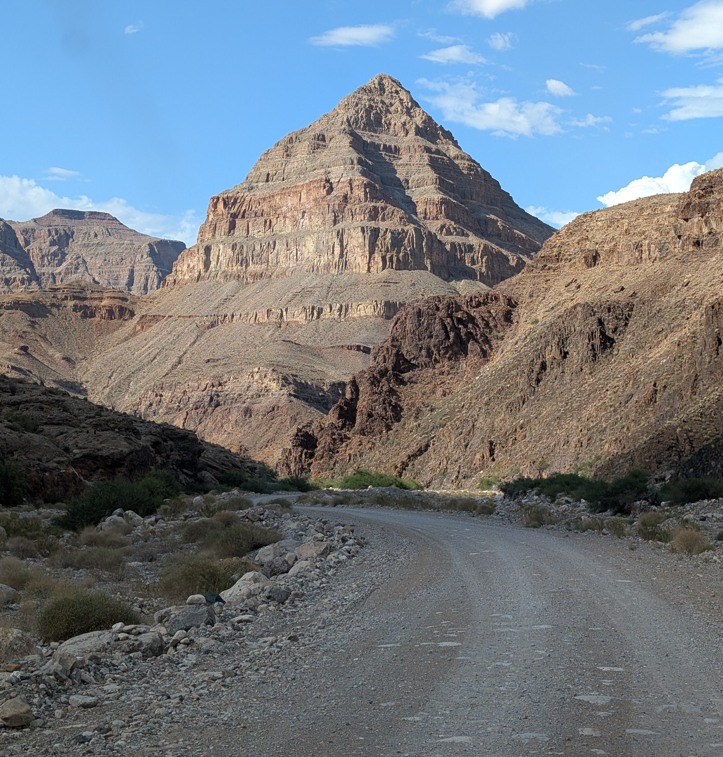
The "diamond" that gives the road its name: Diamond Peak

Without even considering the philosophical objections to building roads through the wilderness world of the Grand Canyon (objections I completely agree with), there are staggering engineering barriers. There are a series of formations, including the Redwall Limestone and the Coconino Sandstone that form sheer cliffs. The locations of trails in the Grand Canyon are controlled almost entirely by the few locations where they can surmount the cliffs of these two layers.

At Diamond Creek, the Hurricane Fault has offset the formations in just such a way that the cliffs can be avoided entirely. For the entire twenty mile length of the road, there is nary a cliff to worry about, as the road follows the bottoms of desert arroyos and washes. The biggest worry is flash floods and mudflows, which can easily shut down the road in July and August during the monsoons (and badly inconvenience river rafters who plan to take out at Diamond Creek). Unfortunately, our storm had all the hallmarks of an intense monsoon storm, and for all we knew, the road would be closed, and the whole endeavor moot. We were running late anyway, and I couldn't know the status of the road until we reached the Peach Springs office of the Game and Fish Service of the Hualapai Nation. We got there, and the sign on the door told me the worst...

All my plans dashed. But what can you do but barge your way into the office and see if the road was really closed? And it turned out that their closure was cautionary, the sign left from earlier in the day when no one had checked the road conditions. The road was okay, and I was given the permit to take our group into the canyon (the form interestingly was a permit to trespass on Hualapai land). It was the only permit given that day, and we would have the Grand Canyon to ourselves! We started down the gravel road, the Colorado River twenty miles away.

One can certainly debate the idea that it's "cheating" to drive to the bottom of the canyon, and there is a certain validity that scenery that hasn't been "earned" by completing a stiff hike might end up being less appreciated. But many people can't handle the very strenuous hiking and many simply don't have the time. Driving down into the canyon is a unique opportunity to study the oldest rocks of the canyon, the ones that are the very hardest to access in any other situation.

Diamond Creek cuts through to the Granite Gorge Metamorphic Suite, which is the oldest group of rocks found in the American Southwest, dating to as early as 1.8 billion years ago. At roadside there are marvelous exposures of schist, gneiss, and pegmatite granite with bright shiny crystals of muscovite mica and quartz.
Outcrops of schist intruded by pink pegmatite granite
A bit farther up the canyon one can see the layers of the Tonto Group, a series of three formations called the Tapeats Sandstone, the Bright Angel Shale, and the Muav Limestone. The three layers formed as the Pacific Ocean transgressed and covered much of the western North American continent in Cambrian time, just over 500 million years ago. The Tapeats Sandstone sits atop the rocks of the Granite Gorge Metamorphic Suite.
The Great Unconformity: the vertically oriented rocks in the lower half of the photo are the ancient metamorphic schist and gneiss. Above the metamorphic rocks are horizontal layers of the Tonto Group.
That last sentence needs a bit more explanation. The boundary between the Tapeats and the Granite Gorge rocks is a profound unconformity representing a gap of more than a billion years. This unconformity is actually called the "Great Unconformity", and is an erosional surface that was witness to not one, but two major mountain-building events. The metamorphic rocks were once the core of a vast mountain range that formed 1.7 billion years ago when the North American continent collided with a set of two exotic terranes, the Yavapai block and the Mazatzal block. Imagine an island the size of California or New Zealand grinding into the edge of a continent along a subduction zone and you will get the picture. This massive mountain range eroded to a flat low-relief surface over the next few hundred million years.
The Great Unconformity up close. Dark brown conglomerate of the Tonto Group rests unconformably atop the ancient metamorphic rocks.
Later on, about a billion years ago, the continent stretched and broke apart, forming a series of fault-block mountain ranges that reached heights similar to the mountains in and around Death Valley National Park today. The rocks of these mountains are exposed in the easternmost part of the Grand Canyon, but they too were eventually eroded down to a low-relief surface as well, although small  ridges a few hundred feet high persisted. Along the lower reaches of Diamond Creek Road, you can lay your hand on a boundary between two rock sequences with a gap of more than a billion years between them. The unconformity can be seen in the photo above where a conglomerate rests on contorted metamorphic rocks in the bit of shadowed ledge. The "Diamond" of Diamond Creek is the uniquely shaped peak on the left side of the photograph. It is actually a sliver of rock caught between two branches of the Hurricane fault system.

Another layer that is prominently exposed along Diamond Creek Road is the Devonian-aged Temple Butte Limestone. Most park visitors never see it because in the eastern section of Grand Canyon National Park the Temple Butte is a discontinuous thin layer that is pretty well invisible from the rim. In western Grand Canyon it is more than 700 feet thick. It formed as a tidal estuary and tidal flats along the edge of the continent about 385 million years ago.
Temple Butte cliffs in Diamond Creek
We reached the end of the road where Diamond Creek flows into the Colorado River, the watercourse responsible for carving the Grand Canyon. It was a moment for the students to cavort in the river for a few minutes, and to wonder at the work the river has done. This spot is where many of those who've rafted the river through the Grand Canyon take out, a usually raucous process, but no one was about on this particular day.
The most "mysterious" aspect of Diamond Creek and Peach Springs Canyon is that the tributary canyons to this creek follow illogical pathways, and are actually older than the Grand Canyon itself! It's an odd problem. Along the upper reaches of Peach Springs Canyon, there are a series of Paleocene to Miocene-aged rocks clinging to the canyon walls. They once filled the canyon, meaning the canyon was carved prior to sixty million years ago, and the rivers that carved it flowed northeast, opposite of the Colorado River today. Apparently the land subsided so that the canyons were filled with sediment, and then they were exhumed when the modern Grand Canyon was carved, most likely within the last four or five million years. There has been more than one Grand Canyon carved through the Colorado Plateau!
Peach Springs Canyon  (red) and the odd channels (blue) that were carved millions of years prior to the Grand Canyon itself (they were buried and exhumed when the modern canyon was carved).
Near the bottom of the road we happened upon a Bighorn Sheep. They were once more common and figured prominently in the Ancestral Pueblo petroglyphs found throughout the region. 
Diamond Creek is a fascinating excursion. It is entirely on Hualapai lands, and they charge a fee of around $17 per person for permission to drive the road. I never mind paying the fee, because the tribe doesn't have many sources of income or all that many jobs on the reservation. The town of Peach Springs where the road starts has a very nice motel and restaurant (and not much else), and if you are a train lover, you'll be able to listen to them all night long. The rails are amongst the busiest you'll ever see. The town is on one of the last remaining stretches of the original Route 66.

Our crew was ready to get to camp, so we drove an hour or so to my brother's cabin where we would spend the next three nights.
Wait a minute. Showers, kitchen, hot tub? You call this roughing it?

Sunday, June 8, 2014

Exploring the Depths of the Grand Canyon...By Car?

The Grand Canyon is one of the great spectacles of the Earth. Millions of people every year stand on the edge of the abyss and peer in, taking in the vivid colors and hidden depths. Tens of thousands venture down some of the few trails that reach into the incredible gorge, and several thousand raft the river. But how many drive the canyon? Did you even know you could?
And no, I'm not talking about visiting the canyon "Thelma and Louise" style...

For more than two hundred river miles, no road crosses the Grand Canyon (plus another hundred miles to Lake Mead). Navajo Bridge near Lee's Ferry is at one end, and Pat Tilman Bridge near Lake Mead is at the other. In between in the depths of Grand Canyon there is a single road that reaches the river. It's called Diamond Creek Road, and it starts on Hualapai Nation lands at Peach Springs. It's a marvelous adventure.

Without even considering the philosophical objections to building roads through the wilderness world of the Grand Canyon (objections I completely agree with), there are staggering engineering barriers. There are a series of formations, including the Redwall Limestone and the Coconino Sandstone that form sheer cliffs. The locations of trails in the Grand Canyon are controlled almost entirely by the few locations where they can surmount the cliffs of these two layers.

At Diamond Creek, the Hurricane Fault has offset the formations in just such a way that the cliffs can be avoided entirely. For the entire twenty mile length of the road, there is nary a cliff to worry about, as the road follows the bottoms of desert arroyos and washes. The biggest worry is flash floods and mudflows, which can easily shut down the road in July and August during the monsoons (and badly inconvenience river rafters who plan to take out at Diamond Creek).
One can certainly discuss the idea that it's "cheating" to drive to the bottom of the canyon, and there is a certain validity that scenery that hasn't been "earned" by completing a stiff hike might end up being less appreciated. But many people can't handle the very strenuous hiking and many simply don't have the time. Driving down into the canyon is a unique opportunity to study the oldest rocks of the canyon, the ones that are the very hardest to access in any other situation.
Diamond Creek cuts through to the Granite Gorge Metamorphic Suite, which is the oldest group of rocks found in the American Southwest, dating to as early as 1.8 billion years ago. At roadside there are marvelous exposures of schist, gneiss, and pegmatite granite with bright shiny crystals of muscovite mica and quartz.
A bit farther up the canyon one can see the layers of the Tonto Group, a series of three formations called the Tapeats Sandstone, the Bright Angel Shale, and the Muav Limestone. The three layers formed as the Pacific Ocean transgressed and covered much of the western North American continent in Cambrian time, just over 500 million years ago. The Tapeats Sandstone sits atop the rocks of the Granite Gorge Metamorphic Suite.

That last sentence needs a bit more explanation. The boundary between the Tapeats and the Granite Gorge rocks is a profound unconformity representing a gap of more than a billion years. This unconformity is actually called the "Great Unconformity", and is an erosional surface that was witness to not one, but two major mountain-building events. The metamorphic rocks were once the core of a vast mountain range that formed 1.7 billion years ago when the North American continent collided with a set of two exotic terranes, the Yavapai block and the Mazatzal block. Imagine an island the size of California or New Zealand grinding into the edge of a continent along a subduction zone and you will get the picture. This massive mountain range eroded to a flat low-relief surface over the next few hundred million years.
Later on, about a billion years ago, the continent stretched and broke apart, forming a series of fault-block mountain ranges that reached heights similar to the mountains in and around Death Valley National Park today. The rocks of these mountains are exposed in the easternmost part of the Grand Canyon, but they too were eventually eroded down to a low-relief surface as well, although small  ridges a few hundred feet high persisted. Along the lower reaches of Diamond Creek Road, you can lay your hand on a boundary between two rock sequences with a gap of more than a billion years between them. The unconformity can be seen in the photo above where a conglomerate rests on contorted metamorphic rocks in the bit of shadowed ledge. The "Diamond" of Diamond Creek is the uniquely shaped peak on the left side of the photograph. It is actually a sliver of rock caught between two branches of the Hurricane fault system.
Another layer that is prominently exposed along Diamond Creek Road is Devonian-aged Temple Butte Limestone. Most park visitors never see it because in the eastern section of Grand Canyon National Park the Temple Butte is a discontinuous thin layer that is pretty well invisible from the rim. In western Grand Canyon it is more than 700 feet thick. It formed as a tidal estuary and tidal flats along the edge of the continent about 385 million years ago.
The most "mysterious" aspect of Diamond Creek and Peach Springs Canyon is that the tributary canyons to this creek are older than the Grand Canyon itself. It's an odd problem. Along the upper reaches of Peach Springs Canyon, there are a series of Paleocene to Miocene-aged rocks clinging to the canyon walls. They once filled the canyon, meaning the canyon was carved prior to sixty million years ago, and the rivers that carved it flowed northeast, opposite of the Colorado River today. Apparently the land subsided so that the canyons were filled with sediment, and then they were exhumed when the modern Grand Canyon was carved, most likely within the last four or five million years.
Photo by Mrs. Geotripper

Diamond Creek is a fascinating excursion. It is entirely on Hualapai lands, and they charge a fee of around $25 per person for permission to drive the road. I never mind paying the fee, because the tribe doesn't have many sources of income or all that many jobs on the reservation. The town of Peach Springs where the road starts has a very nice motel and restaurant (and not much else), and if you are a train lover, you'll be able to listen to them all night long. The rails are amongst the busiest you'll ever see.The town is on one of the last remaining stretches of the original Route 66.

Friday, July 6, 2012

The Abandoned Lands...A Journey Through the Colorado Plateau: The Grandest Canyon


"The region . . . is, of course, altogether valueless. It can be approached only from the south, and after entering it, there is nothing to do but leave. Ours has been the first and the last party of whites to visit this profitless locality. It seems intended by nature that the Colorado River, along the greater portion of its lonely and majestic way, shall be unvisited and undisturbed."

Joseph Ives (1851)

Joseph Ives did a lot of hard and dangerous work to be remembered only for the famous quote shown above. His expedition spent months exploring the region, collecting huge amounts of data on the geology, hydrology and biology. Often cited as one of the most incorrect predictions ever uttered, the statement to a certain extent is actually true. Nearly five million people do in fact visit Grand Canyon National Park every year, but the vast majority of them merely stand on the rim and look down. Tens of thousands may hike down the handful of popular trails, and a few thousand float down the Colorado River. But hundreds of square miles of the park see no visitors at all most years. The canyon is mostly inaccessible, and I have no doubt that there are many new discoveries to be made about the geology and biology.

Profitless? Pretty much true. A handful of mines in the Grand Canyon made modest profits, but most mining ventures failed, due to poor ore values and lack of access.There is no lumber to speak of within the canyon, and utilizing the water of the Colorado River was impossible until the great dams of the twentieth century, and they aren't actually in the Grand Canyon. Tourism is the only economic gold mine around here.

It is possible to look at the canyon and not be impressed. When Coronado's troops reached the rim in 1540, their perspective was so skewed that they thought the mile-deep canyon was only a thousand feet deep and that the Colorado River was only six feet across. A day spent trying to scramble down the cliffs quickly cleared the misconception, and they left the region. For literally centuries.

I think the same sort of thing happens with casual tourists, too. It is so easy sometimes to step out of an RV where one has been watching a large screen tv and see the vast depth of the canyon as a flat canvas, very colorful, but without depth. It's so easy to snap a few pictures and head on to the next overlook or the next park. As has been said so many times, the only way to really appreciate the scale of the Grand Canyon is to see it from the inside out, to walk it, to ride a burro into the depths, or to float on a raft down the Colorado River.

I have no doubt that someone also thought of the other alternative: build paved roads and let people wear out their brakes on a drive down to the bottom and look back up before destroying their transmissions and radiators on the steep climb back out. There are just one or two problems with that: besides invading the precious wilderness that lies below the rim, there is the Coconino Sandstone, and the Redwall Limestone. There are engineering problems with practically all the Paleozoic and Proterozoic formations of the canyon, but these two are especially troublesome. They are cliffs of such uniformity throughout the Grand Canyon that there are only a few dozen places where trails can breach the inner canyon. Roads? It just can't be done (or else it would have done in the formative years of the National Park Service; think of Going to the Sun Highway at Glacier, Tioga Pass in Yosemite, or the Crater Lake Rim Highway). If you have only that precious few days of vacation, you are going to want to see as much as you can of all the parks in the region, and leave the four day backpack to that unspecified future time when you get back into shape...
Yeah, they got the trail through the Redwall Limestone here; but where would you put a highway?
Seeing the Grand Canyon on foot made me a geologist. The week-long trip I took in 1976 was one of the pivotal events of my life. There is simply no substitute for walking the full depth of each of the layers of the canyon in turn, seeing the crossbedding, the ripplemarks, the fossils, the faults and folds to truly appreciate the magnitude of geologic time and the complexities of the history of these rocks. It is awe-inspiring to lay one's hands on the Great Unconformity and touch a billion years between your fingertips. There is nothing like it, and it is an almost impossible experience to offer in the confines of today's budgetary limitations in education. We can no longer take just eight students and make a viable class that will pass muster with the bean-counters in the administration.

So that was my conundrum last month. How could I share the incredible story of the Grand Canyon with my students when there were 34 of us, and only a day? It turns out that there was one place where I could drive them down the canyon: Peach Springs Road and Diamond Creek on the Hualapai Reservation in western Grand Canyon. It's a winding 21 mile road that reaches the Colorado River 4,000 feet down in the gorge. But how could they have constructed this road? I don't know when it was built or why (anyone out there have some info?), but they did it. It was all the fault of...well...the fault. The Hurricane fault to be specific. The fault has dropped the rocks on the west side over a thousand feet, so a route could be selected that simply never had to cross the cliffs of the Coconino or Redwall (see the diagram below). The road starts in the Devonian Temple Butte Limestone, and only has to drop through the Cambrian sediments and the underlying complex of Proterozoic gneiss and granite, which is rugged enough, but the erosion of Diamond Creek did most of the work before the roadbuilders arrived.

The road is utilized as a major take-out point on the Colorado River by the rafters. It is not a particularly good choice for the casual tourist. It's not so much that it is too rugged, but in summer the temperatures are sizzling, and this exacts a toll on radiator and electrical systems. You may remember reading about my own failure to reach the Colorado River a month earlier due to car problems. It's also expensive; the Hualapai nation charges $25 per person to drive the canyon (I didn't mind paying; tourism is pretty much the sole income for the tribe). But we did it with students this year for the first time ever. That story comes in the next post.

Here is the explanation of my "abandonment" theme for this series: http://geotripper.blogspot.com/2012/06/abandoned-landsa-journey-through.html