Showing posts with label Muav Limestone. Show all posts

Monday, June 23, 2025

Journeys in the Back of Beyond: Simply Driving to the Bottom of the Grand Canyon (!?)


Running a geology field studies course is nothing if not stressful. Right on the heels of the most intense storm I've experienced on one of these trips, it was morning and we were on the road to the next thing. A simple thing really, just driving down to the bottom of the Grand Canyon. But I had no way of knowing it would happen, given the storms of the previous night. Had the storm affected the road into the canyon?
 
The Grand Canyon is one of the great spectacles of the Earth. Millions of people every year stand on the edge of the abyss and peer in, taking in the vivid colors and hidden depths. Tens of thousands venture down some of the few trails that reach into the incredible gorge, and several thousand raft the river. But how many drive the canyon? Did you even know you could?
And no, I'm not talking about visiting the canyon "Thelma and Louise" style...

For more than two hundred river miles, no road crosses the Grand Canyon (plus another hundred miles along the shores of Lake Mead). Navajo Bridge near Lee's Ferry is at one end, and Pat Tilman Bridge near Hoover Dam is at the other. In between in the depths of Grand Canyon there is a single road that reaches the river. It's called Diamond Creek Road, and it starts on Hualapai Nation land at Peach Springs, Arizona. It's a marvelous adventure.
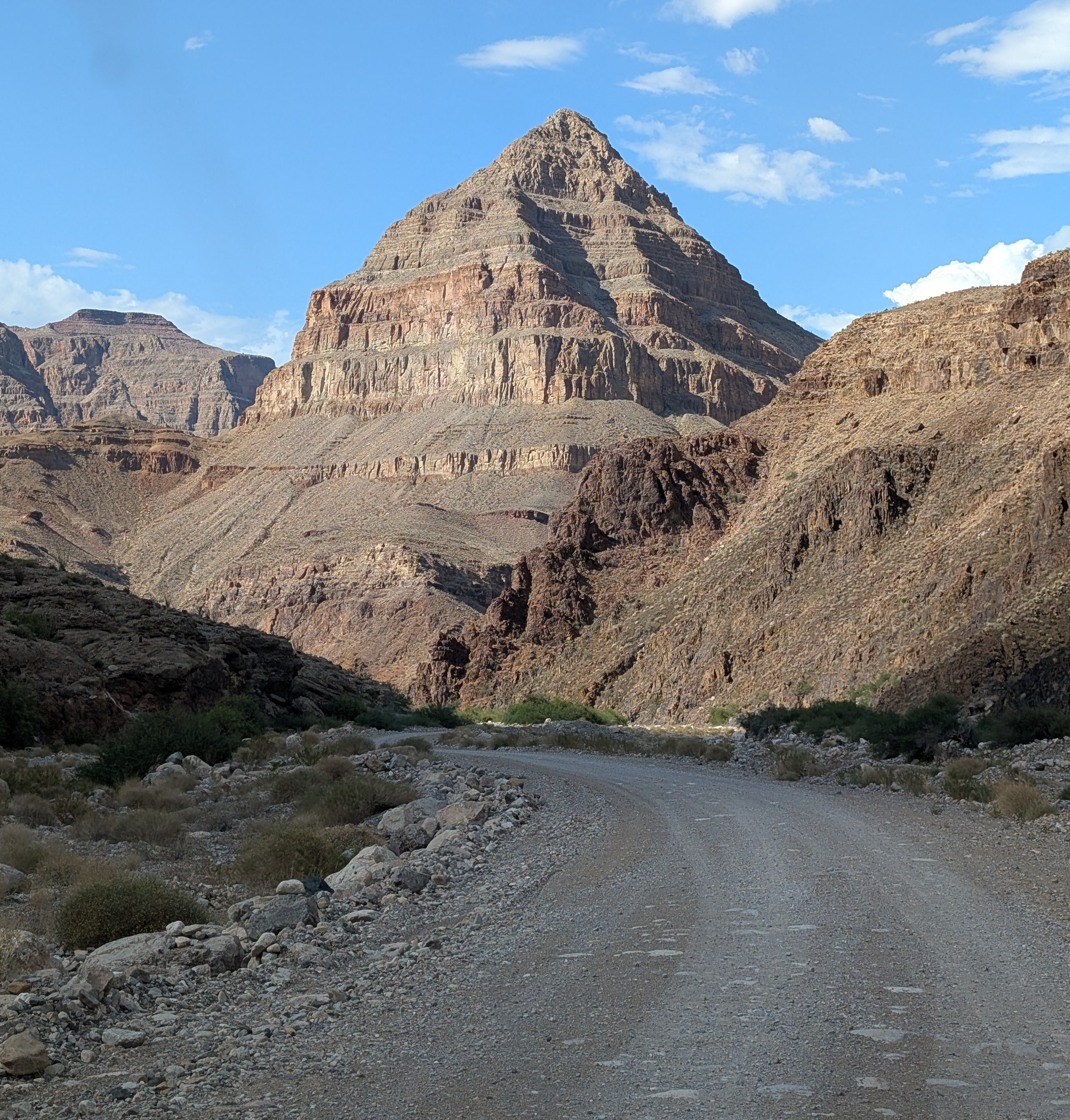
The "diamond" that gives the road its name: Diamond Peak

Without even considering the philosophical objections to building roads through the wilderness world of the Grand Canyon (objections I completely agree with), there are staggering engineering barriers. There are a series of formations, including the Redwall Limestone and the Coconino Sandstone that form sheer cliffs. The locations of trails in the Grand Canyon are controlled almost entirely by the few locations where they can surmount the cliffs of these two layers.

At Diamond Creek, the Hurricane Fault has offset the formations in just such a way that the cliffs can be avoided entirely. For the entire twenty mile length of the road, there is nary a cliff to worry about, as the road follows the bottoms of desert arroyos and washes. The biggest worry is flash floods and mudflows, which can easily shut down the road in July and August during the monsoons (and badly inconvenience river rafters who plan to take out at Diamond Creek). Unfortunately, our storm had all the hallmarks of an intense monsoon storm, and for all we knew, the road would be closed, and the whole endeavor moot. We were running late anyway, and I couldn't know the status of the road until we reached the Peach Springs office of the Game and Fish Service of the Hualapai Nation. We got there, and the sign on the door told me the worst...

All my plans dashed. But what can you do but barge your way into the office and see if the road was really closed? And it turned out that their closure was cautionary, the sign left from earlier in the day when no one had checked the road conditions. The road was okay, and I was given the permit to take our group into the canyon (the form interestingly was a permit to trespass on Hualapai land). It was the only permit given that day, and we would have the Grand Canyon to ourselves! We started down the gravel road, the Colorado River twenty miles away.

One can certainly debate the idea that it's "cheating" to drive to the bottom of the canyon, and there is a certain validity that scenery that hasn't been "earned" by completing a stiff hike might end up being less appreciated. But many people can't handle the very strenuous hiking and many simply don't have the time. Driving down into the canyon is a unique opportunity to study the oldest rocks of the canyon, the ones that are the very hardest to access in any other situation.

Diamond Creek cuts through to the Granite Gorge Metamorphic Suite, which is the oldest group of rocks found in the American Southwest, dating to as early as 1.8 billion years ago. At roadside there are marvelous exposures of schist, gneiss, and pegmatite granite with bright shiny crystals of muscovite mica and quartz.
Outcrops of schist intruded by pink pegmatite granite
A bit farther up the canyon one can see the layers of the Tonto Group, a series of three formations called the Tapeats Sandstone, the Bright Angel Shale, and the Muav Limestone. The three layers formed as the Pacific Ocean transgressed and covered much of the western North American continent in Cambrian time, just over 500 million years ago. The Tapeats Sandstone sits atop the rocks of the Granite Gorge Metamorphic Suite.
The Great Unconformity: the vertically oriented rocks in the lower half of the photo are the ancient metamorphic schist and gneiss. Above the metamorphic rocks are horizontal layers of the Tonto Group.
That last sentence needs a bit more explanation. The boundary between the Tapeats and the Granite Gorge rocks is a profound unconformity representing a gap of more than a billion years. This unconformity is actually called the "Great Unconformity", and is an erosional surface that was witness to not one, but two major mountain-building events. The metamorphic rocks were once the core of a vast mountain range that formed 1.7 billion years ago when the North American continent collided with a set of two exotic terranes, the Yavapai block and the Mazatzal block. Imagine an island the size of California or New Zealand grinding into the edge of a continent along a subduction zone and you will get the picture. This massive mountain range eroded to a flat low-relief surface over the next few hundred million years.
The Great Unconformity up close. Dark brown conglomerate of the Tonto Group rests unconformably atop the ancient metamorphic rocks.
Later on, about a billion years ago, the continent stretched and broke apart, forming a series of fault-block mountain ranges that reached heights similar to the mountains in and around Death Valley National Park today. The rocks of these mountains are exposed in the easternmost part of the Grand Canyon, but they too were eventually eroded down to a low-relief surface as well, although small  ridges a few hundred feet high persisted. Along the lower reaches of Diamond Creek Road, you can lay your hand on a boundary between two rock sequences with a gap of more than a billion years between them. The unconformity can be seen in the photo above where a conglomerate rests on contorted metamorphic rocks in the bit of shadowed ledge. The "Diamond" of Diamond Creek is the uniquely shaped peak on the left side of the photograph. It is actually a sliver of rock caught between two branches of the Hurricane fault system.

Another layer that is prominently exposed along Diamond Creek Road is the Devonian-aged Temple Butte Limestone. Most park visitors never see it because in the eastern section of Grand Canyon National Park the Temple Butte is a discontinuous thin layer that is pretty well invisible from the rim. In western Grand Canyon it is more than 700 feet thick. It formed as a tidal estuary and tidal flats along the edge of the continent about 385 million years ago.
Temple Butte cliffs in Diamond Creek
We reached the end of the road where Diamond Creek flows into the Colorado River, the watercourse responsible for carving the Grand Canyon. It was a moment for the students to cavort in the river for a few minutes, and to wonder at the work the river has done. This spot is where many of those who've rafted the river through the Grand Canyon take out, a usually raucous process, but no one was about on this particular day.
The most "mysterious" aspect of Diamond Creek and Peach Springs Canyon is that the tributary canyons to this creek follow illogical pathways, and are actually older than the Grand Canyon itself! It's an odd problem. Along the upper reaches of Peach Springs Canyon, there are a series of Paleocene to Miocene-aged rocks clinging to the canyon walls. They once filled the canyon, meaning the canyon was carved prior to sixty million years ago, and the rivers that carved it flowed northeast, opposite of the Colorado River today. Apparently the land subsided so that the canyons were filled with sediment, and then they were exhumed when the modern Grand Canyon was carved, most likely within the last four or five million years. There has been more than one Grand Canyon carved through the Colorado Plateau!
Peach Springs Canyon  (red) and the odd channels (blue) that were carved millions of years prior to the Grand Canyon itself (they were buried and exhumed when the modern canyon was carved).
Near the bottom of the road we happened upon a Bighorn Sheep. They were once more common and figured prominently in the Ancestral Pueblo petroglyphs found throughout the region. 
Diamond Creek is a fascinating excursion. It is entirely on Hualapai lands, and they charge a fee of around $17 per person for permission to drive the road. I never mind paying the fee, because the tribe doesn't have many sources of income or all that many jobs on the reservation. The town of Peach Springs where the road starts has a very nice motel and restaurant (and not much else), and if you are a train lover, you'll be able to listen to them all night long. The rails are amongst the busiest you'll ever see. The town is on one of the last remaining stretches of the original Route 66.

Our crew was ready to get to camp, so we drove an hour or so to my brother's cabin where we would spend the next three nights.
Wait a minute. Showers, kitchen, hot tub? You call this roughing it?

Sunday, June 8, 2014

Exploring the Depths of the Grand Canyon...By Car?

The Grand Canyon is one of the great spectacles of the Earth. Millions of people every year stand on the edge of the abyss and peer in, taking in the vivid colors and hidden depths. Tens of thousands venture down some of the few trails that reach into the incredible gorge, and several thousand raft the river. But how many drive the canyon? Did you even know you could?
And no, I'm not talking about visiting the canyon "Thelma and Louise" style...

For more than two hundred river miles, no road crosses the Grand Canyon (plus another hundred miles to Lake Mead). Navajo Bridge near Lee's Ferry is at one end, and Pat Tilman Bridge near Lake Mead is at the other. In between in the depths of Grand Canyon there is a single road that reaches the river. It's called Diamond Creek Road, and it starts on Hualapai Nation lands at Peach Springs. It's a marvelous adventure.

Without even considering the philosophical objections to building roads through the wilderness world of the Grand Canyon (objections I completely agree with), there are staggering engineering barriers. There are a series of formations, including the Redwall Limestone and the Coconino Sandstone that form sheer cliffs. The locations of trails in the Grand Canyon are controlled almost entirely by the few locations where they can surmount the cliffs of these two layers.

At Diamond Creek, the Hurricane Fault has offset the formations in just such a way that the cliffs can be avoided entirely. For the entire twenty mile length of the road, there is nary a cliff to worry about, as the road follows the bottoms of desert arroyos and washes. The biggest worry is flash floods and mudflows, which can easily shut down the road in July and August during the monsoons (and badly inconvenience river rafters who plan to take out at Diamond Creek).
One can certainly discuss the idea that it's "cheating" to drive to the bottom of the canyon, and there is a certain validity that scenery that hasn't been "earned" by completing a stiff hike might end up being less appreciated. But many people can't handle the very strenuous hiking and many simply don't have the time. Driving down into the canyon is a unique opportunity to study the oldest rocks of the canyon, the ones that are the very hardest to access in any other situation.
Diamond Creek cuts through to the Granite Gorge Metamorphic Suite, which is the oldest group of rocks found in the American Southwest, dating to as early as 1.8 billion years ago. At roadside there are marvelous exposures of schist, gneiss, and pegmatite granite with bright shiny crystals of muscovite mica and quartz.
A bit farther up the canyon one can see the layers of the Tonto Group, a series of three formations called the Tapeats Sandstone, the Bright Angel Shale, and the Muav Limestone. The three layers formed as the Pacific Ocean transgressed and covered much of the western North American continent in Cambrian time, just over 500 million years ago. The Tapeats Sandstone sits atop the rocks of the Granite Gorge Metamorphic Suite.

That last sentence needs a bit more explanation. The boundary between the Tapeats and the Granite Gorge rocks is a profound unconformity representing a gap of more than a billion years. This unconformity is actually called the "Great Unconformity", and is an erosional surface that was witness to not one, but two major mountain-building events. The metamorphic rocks were once the core of a vast mountain range that formed 1.7 billion years ago when the North American continent collided with a set of two exotic terranes, the Yavapai block and the Mazatzal block. Imagine an island the size of California or New Zealand grinding into the edge of a continent along a subduction zone and you will get the picture. This massive mountain range eroded to a flat low-relief surface over the next few hundred million years.
Later on, about a billion years ago, the continent stretched and broke apart, forming a series of fault-block mountain ranges that reached heights similar to the mountains in and around Death Valley National Park today. The rocks of these mountains are exposed in the easternmost part of the Grand Canyon, but they too were eventually eroded down to a low-relief surface as well, although small  ridges a few hundred feet high persisted. Along the lower reaches of Diamond Creek Road, you can lay your hand on a boundary between two rock sequences with a gap of more than a billion years between them. The unconformity can be seen in the photo above where a conglomerate rests on contorted metamorphic rocks in the bit of shadowed ledge. The "Diamond" of Diamond Creek is the uniquely shaped peak on the left side of the photograph. It is actually a sliver of rock caught between two branches of the Hurricane fault system.
Another layer that is prominently exposed along Diamond Creek Road is Devonian-aged Temple Butte Limestone. Most park visitors never see it because in the eastern section of Grand Canyon National Park the Temple Butte is a discontinuous thin layer that is pretty well invisible from the rim. In western Grand Canyon it is more than 700 feet thick. It formed as a tidal estuary and tidal flats along the edge of the continent about 385 million years ago.
The most "mysterious" aspect of Diamond Creek and Peach Springs Canyon is that the tributary canyons to this creek are older than the Grand Canyon itself. It's an odd problem. Along the upper reaches of Peach Springs Canyon, there are a series of Paleocene to Miocene-aged rocks clinging to the canyon walls. They once filled the canyon, meaning the canyon was carved prior to sixty million years ago, and the rivers that carved it flowed northeast, opposite of the Colorado River today. Apparently the land subsided so that the canyons were filled with sediment, and then they were exhumed when the modern Grand Canyon was carved, most likely within the last four or five million years.
Photo by Mrs. Geotripper

Diamond Creek is a fascinating excursion. It is entirely on Hualapai lands, and they charge a fee of around $25 per person for permission to drive the road. I never mind paying the fee, because the tribe doesn't have many sources of income or all that many jobs on the reservation. The town of Peach Springs where the road starts has a very nice motel and restaurant (and not much else), and if you are a train lover, you'll be able to listen to them all night long. The rails are amongst the busiest you'll ever see.The town is on one of the last remaining stretches of the original Route 66.

Wednesday, September 11, 2013

Into the Great Unknown: Mad Cats and Amoebas? Trying to Keep Names Straight in the Grandest Canyon

Morning dawned on our crew at Doris Camp on Mile 138 of our rafting journey through the Grand Canyon, a trip I've been calling "Into the Great Unknown". The river was known well enough to our boatmen, but as I've pointed out, this was my first trip, and so I had a heck of a time keeping the geography straight. We had reached day 12 of a 16 day trip, and still had 90 miles to go. We needed to make up for some leisurely days during the previous week. The plan for the day: 27 miles, our longest day of all. We intended to camp at Tuckup.
Doris was one of the most unique camps of our trip, with a narrow strip of sand hugging the base of a high overhanging cliff of Tapeats Sandstone (both of the above pictures). After all the concentration on slope failures in the previous post, I'm glad to report there were no rock falls during the night. I did keep my eye on one precariously perched barrel cactus right over the cooking area. It stayed put.
The character of the river changed once again. We had left behind the rugged cliffs of the Granite Gorge, and had "climbed" back into the lower Paleozoic sediments: the Tapeats, Bright Angel and Muav strata. We hadn't actually "climbed", although I was ready to believe that the river was capable of just about anything. Instead, the rocks were gently folded and inclined to bring the Paleozoic sediments to a lower elevation. We had reached the beginning of a 40 mile stretch of the river called the Muav Gorge.
I was reminded somewhat of Marble Canyon, a fond memory, although the cliffs in this stretched towered a few thousand feet higher than those at Marble. Mercifully enough the river had only one worrisome rapid, Upset, which is rated between 3 and 8 depending on flow conditions. Among the other ten rapids, none rated higher than a four.
Much of the day involved floating through placid waters in deep and often shaded canyons. I was enjoying myself immensely. Pete of course had to row through the placid canyons, sometimes against the wind. His opinion may differ!
We had just one major side canyon to explore on this day, with a name I was having trouble getting straight. It is called Mad Cat Amoeba, or at least that's just what I kept hearing when anyone said the name over the course of the morning. They were talking about Matkatamiba Canyon, which is a favorite of the boatmen. They had been talking about it for the last day or two.

There were a couple of problems. The canyon entrance is right at the top of a rapid, a sort of "you have one chance to get it right" kind of docking situation. And the docking spot is a narrow pool (no beach), so the boats have to be lashed together to hold them in place. The canyon is an extremely popular stop, and we had to hope no one was there. As it turned out a big group was leaving just as we pulled up.

Another potential problem is flash flooding, which we didn't need to fret about, but you can see what happened here in 2011 at this website: http://www.youtube.com/watch?v=yi1k9dvXjXY. Some of their boats were ripped loose and drifted downstream, while others got stacked on top of each other, with a loss of some supplies to the currents of the river.
There are two ways to get into the pleasant upper canyon: walk right up the narrows and do some rock climbing, or take the high rocky trail and...do some climbing. Both choices are visible in the picture above. I took the high road...
I arrived at the "Patio", a large amphitheater-like place deep in the shade (it was a very hot day). A pleasant clear trickle of water was flowing down the canyon. After all the grand vistas of the previous 12 days, I was starting to focus on the little things, like reflections on the water.
There seem to be few things more precious than water flowing through an intensely arid desert. The heat just accented the coolness of the shadows and the sound of the splashing stream.
 I spent some time on hands and knees looking for some of my shots.
The upper canyon beckoned, and I started that way, but it opened up into the blazing sun, and became much more rocky. There have been fairly recent flooding events. I turned back into the cool shadows.
It was a thoroughly pleasant visit, and I didn't really want to get back on the rafts just yet, but we had a lot of miles to go on this particular day.
When gazing at these steep cliffs and canyons, we sometimes make comparisons to cathedrals. The analogy is faulty. No human-built cathedral can match a canyon crafted by the gods.
We got back on the river for a few miles and then we took a lunch break at Ledges Camp and spent some more pleasant moments on the eroded benches of Muav Limestone.
We were approaching the mouth of Havasu Canyon and for a few moments we had a view of Mt. Sinyella, a peak sacred to the nearby Havasupai people (below). We just plain didn't have the time to explore Havasu Canyon, but the blue-green water looked inviting.
We moved down the canyon through the serene gorges. Upset Rapid required a scout, which I found made me apprehensive. We punched our way through the waves with no problems.
 The reflections on the water were mesmerizing. It was a beautiful stretch of canyon.
 We got to our expected camp and found it occupied by a large group already, so a 27 mile day turned into a 29 mile day. We reached the large barren campsite located at the base of National Canyon. We were beat (Pete rowed 26 miles, while I rowed just two or three miles). The boatmen were talking about Lava Falls Rapid again. It now loomed ahead of us; it was one day away...I didn't really sleep well, but the Milky Way was gorgeous.

Saturday, August 24, 2013

Into the Great Unknown: Looking for the Rivers Within the Rivers of Marble Canyon

The Grand Canyon has many moods. So many of my pictures show a canyon bathed in bright sunlight and vivid colors, but twilight often revealed softer tones. The picture above is the view from my campsite at Buck Farm Creek at dusk on the third night of the trip.

We continued our journey into the Great Unknown of the Colorado River. On day four we were expecting to make for Nankoweap Creek about 11 miles downstream. For me it was the chance to find the "river" within the river. That's not some kind of philosophical quest. It was a geological thing, to be explained shortly. But before that, we did some exploring with the extra time afforded by a short distance on the river.

As we often did, we explored the area around our camp while taking advantage of the shade. We headed up Buck Farm Canyon just to see what could be seen. There were a lot of large fallen boulders of Redwall Limestone littering the lower slopes.
Buck Farm quickly narrowed as we climbed up the canyon. We had reached deeper into the crust and were now walking on ledges of Muav Limestone, which in most places underlies the Redwall Limestone. It seems simple to say that one layer sits on top of another, but there is just a bit of time difference between the two layers: the Muav dates from the late Cambrian Period, while the Redwall is Mississippian in age. More than 150 million years elapsed between the deposition of the two layers. That's the same time period that separates the Jurassic (and her many dinosaurs) and our own current era. What happened here?
We climbed over the dry talus slopes and eventually discovered a verdant canyon and even a small clear trickling stream. It was a nice little explore, but now the sun was shining down on us, furiously hot. We headed back to the river.
It was another day remarkably free of large rapids, with only President Harding Rapid (4) standing in our way. As we drifted down the river, more gigantic caverns could be seen in the Redwall cliffs. I think the alcove below is called the Royal Arches.
We also continued to see evidence of recent mass wasting activity along the river. The rockfall seen in the picture below shows a truer color of the Redwall Limestone. It's gray on fresh surfaces, but is often stained by iron oxides leaching out of the overlying Supai Group.
Mile 43 revealed an odd sight. A thousand years ago, the Ancestral Puebloans constructed a foot bridge across ledges of Muav Limestone. From river level we could see no sign of a trail or possible route on either side of the bridge, but there it was. We joked that it was a ruse designed to catch their enemies. They would climb up there to see where it went, where they could be picked off at random.
Some of the Cambrian layers in the Grand Canyon are greenish in color, especially the Bright Angel Shale. The color comes from a mineral called glauconite. The Bright Angel is composed of what used to be ocean-floor muds, and generally forms slopes. Where freshly carved by the river, it formed the ledges seen below.
At Mile 47, we reached Saddle Canyon. I kind of awoke from my entrancement and prepared to stroll up the gentle tributary valley. I asked about the cut in talus slopes to the left of the canyon. "Oh, that's the trail" they said, "the canyon itself is far too steep to go climbing in". Oh geesh, this wasn't going to be at all that easy! We started climbing the incredibly steep talus slope, up through several hundred feet of Bright Angel and Muav layers. It...was...hot.
 As always, though, the view of the river was wonderful.
 The "trail" leveled briefly. It was wonderful not stepping up and over the large boulders.
The stream valley rose to meet the trail, and suddenly we were in a merry little paradise. It's amazing what a little bit of water in the desert can do. Life was everywhere.
We reached the small waterfall and the lusciously cool pool at the base. My picture doesn't have people in it, but I can assure you that every one of us submerged ourselves under the water.
At this time of year I didn't expect to find many flowers, but in the cool moist micro-climate of Saddle Canyon there were some beautiful columbines, one of my favorite flowers.
 I spoke of a river within a river in the title. I was looking for something I had never seen before: the Temple Butte Formation. The Temple Butte is Devonian in age, around 400 million years, which puts the formation between the overlying Redwall and the underlying Muav Limestone. But it isn't a continuous layer. The Muav Limestone was exposed to erosion and eventually developed a series of river channels that ultimately filled with limestone as sea level rose in Devonian time. In other areas, the limestone covered the whole landscape, but after its deposition, the Temple Butte in eastern Grand Canyon was eroded again, leaving only lenses of the formation in the 400 million year old river channels. There are ancient rivers in the depths of the modern river canyon.
Walking out of Saddle Canyon, I spied a really nice example of the purplish Temple Butte between the Redwall and the Muav. If you can't quite visualize what I've been describing, I annotated the picture below. I missed the formation on my previous trips in the canyon, but once I saw it and knew what I was seeing, I began seeing it everywhere!
We continued to float down the river for four miles to our camp at Little Nankoweap Creek. The canyon was beautiful beyond words. Pete let me row again, and I even traversed two gigantic rapids. Okay, they were riffles. Okay, they weren't even that...they were piffles. But I did manage to navigate the raft into camp!