Showing posts with label Bright Angel Shale. Show all posts

Monday, June 23, 2025

Journeys in the Back of Beyond: Simply Driving to the Bottom of the Grand Canyon (!?)


Running a geology field studies course is nothing if not stressful. Right on the heels of the most intense storm I've experienced on one of these trips, it was morning and we were on the road to the next thing. A simple thing really, just driving down to the bottom of the Grand Canyon. But I had no way of knowing it would happen, given the storms of the previous night. Had the storm affected the road into the canyon?
 
The Grand Canyon is one of the great spectacles of the Earth. Millions of people every year stand on the edge of the abyss and peer in, taking in the vivid colors and hidden depths. Tens of thousands venture down some of the few trails that reach into the incredible gorge, and several thousand raft the river. But how many drive the canyon? Did you even know you could?
And no, I'm not talking about visiting the canyon "Thelma and Louise" style...

For more than two hundred river miles, no road crosses the Grand Canyon (plus another hundred miles along the shores of Lake Mead). Navajo Bridge near Lee's Ferry is at one end, and Pat Tilman Bridge near Hoover Dam is at the other. In between in the depths of Grand Canyon there is a single road that reaches the river. It's called Diamond Creek Road, and it starts on Hualapai Nation land at Peach Springs, Arizona. It's a marvelous adventure.
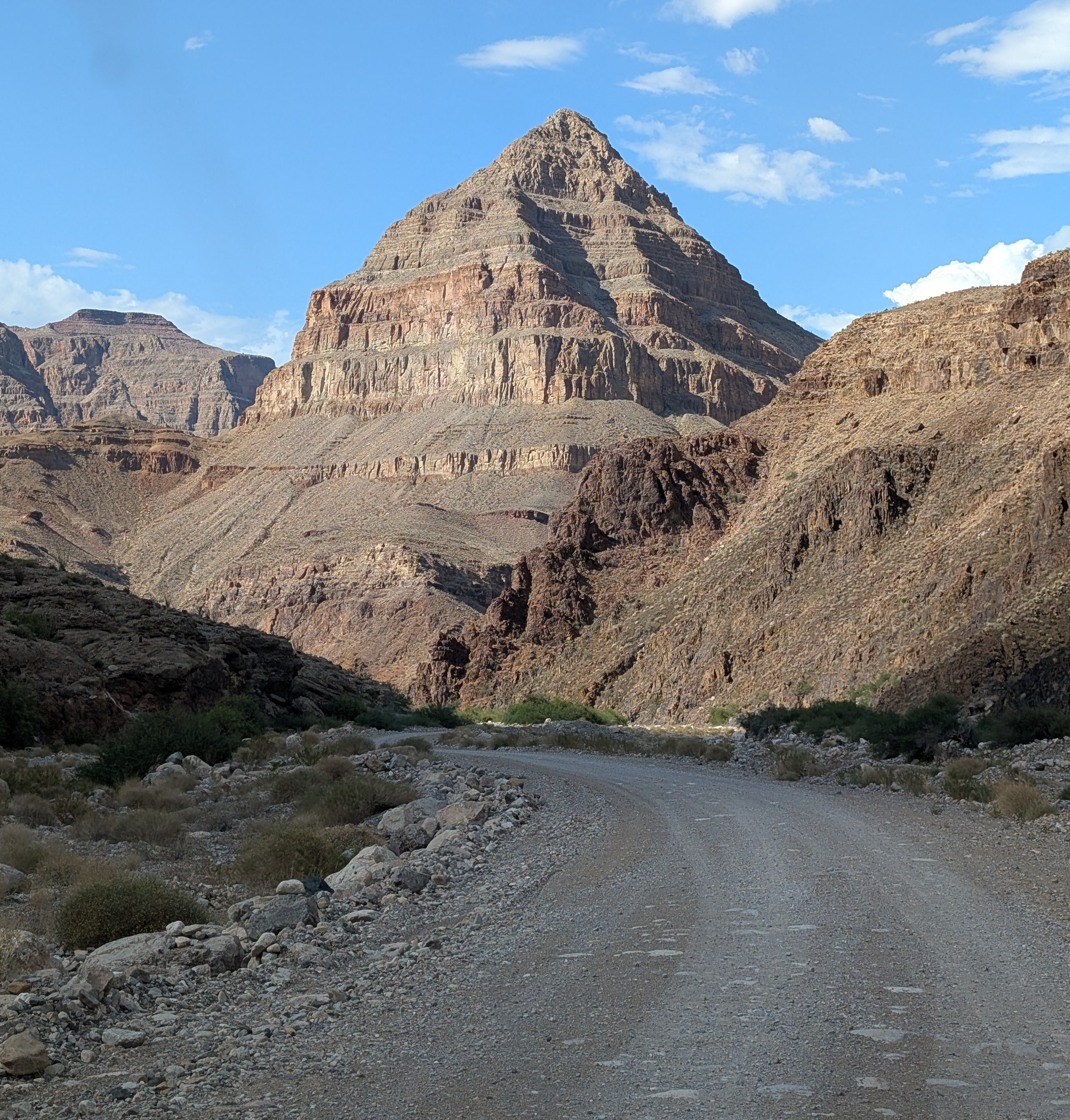
The "diamond" that gives the road its name: Diamond Peak

Without even considering the philosophical objections to building roads through the wilderness world of the Grand Canyon (objections I completely agree with), there are staggering engineering barriers. There are a series of formations, including the Redwall Limestone and the Coconino Sandstone that form sheer cliffs. The locations of trails in the Grand Canyon are controlled almost entirely by the few locations where they can surmount the cliffs of these two layers.

At Diamond Creek, the Hurricane Fault has offset the formations in just such a way that the cliffs can be avoided entirely. For the entire twenty mile length of the road, there is nary a cliff to worry about, as the road follows the bottoms of desert arroyos and washes. The biggest worry is flash floods and mudflows, which can easily shut down the road in July and August during the monsoons (and badly inconvenience river rafters who plan to take out at Diamond Creek). Unfortunately, our storm had all the hallmarks of an intense monsoon storm, and for all we knew, the road would be closed, and the whole endeavor moot. We were running late anyway, and I couldn't know the status of the road until we reached the Peach Springs office of the Game and Fish Service of the Hualapai Nation. We got there, and the sign on the door told me the worst...

All my plans dashed. But what can you do but barge your way into the office and see if the road was really closed? And it turned out that their closure was cautionary, the sign left from earlier in the day when no one had checked the road conditions. The road was okay, and I was given the permit to take our group into the canyon (the form interestingly was a permit to trespass on Hualapai land). It was the only permit given that day, and we would have the Grand Canyon to ourselves! We started down the gravel road, the Colorado River twenty miles away.

One can certainly debate the idea that it's "cheating" to drive to the bottom of the canyon, and there is a certain validity that scenery that hasn't been "earned" by completing a stiff hike might end up being less appreciated. But many people can't handle the very strenuous hiking and many simply don't have the time. Driving down into the canyon is a unique opportunity to study the oldest rocks of the canyon, the ones that are the very hardest to access in any other situation.

Diamond Creek cuts through to the Granite Gorge Metamorphic Suite, which is the oldest group of rocks found in the American Southwest, dating to as early as 1.8 billion years ago. At roadside there are marvelous exposures of schist, gneiss, and pegmatite granite with bright shiny crystals of muscovite mica and quartz.
Outcrops of schist intruded by pink pegmatite granite
A bit farther up the canyon one can see the layers of the Tonto Group, a series of three formations called the Tapeats Sandstone, the Bright Angel Shale, and the Muav Limestone. The three layers formed as the Pacific Ocean transgressed and covered much of the western North American continent in Cambrian time, just over 500 million years ago. The Tapeats Sandstone sits atop the rocks of the Granite Gorge Metamorphic Suite.
The Great Unconformity: the vertically oriented rocks in the lower half of the photo are the ancient metamorphic schist and gneiss. Above the metamorphic rocks are horizontal layers of the Tonto Group.
That last sentence needs a bit more explanation. The boundary between the Tapeats and the Granite Gorge rocks is a profound unconformity representing a gap of more than a billion years. This unconformity is actually called the "Great Unconformity", and is an erosional surface that was witness to not one, but two major mountain-building events. The metamorphic rocks were once the core of a vast mountain range that formed 1.7 billion years ago when the North American continent collided with a set of two exotic terranes, the Yavapai block and the Mazatzal block. Imagine an island the size of California or New Zealand grinding into the edge of a continent along a subduction zone and you will get the picture. This massive mountain range eroded to a flat low-relief surface over the next few hundred million years.
The Great Unconformity up close. Dark brown conglomerate of the Tonto Group rests unconformably atop the ancient metamorphic rocks.
Later on, about a billion years ago, the continent stretched and broke apart, forming a series of fault-block mountain ranges that reached heights similar to the mountains in and around Death Valley National Park today. The rocks of these mountains are exposed in the easternmost part of the Grand Canyon, but they too were eventually eroded down to a low-relief surface as well, although small  ridges a few hundred feet high persisted. Along the lower reaches of Diamond Creek Road, you can lay your hand on a boundary between two rock sequences with a gap of more than a billion years between them. The unconformity can be seen in the photo above where a conglomerate rests on contorted metamorphic rocks in the bit of shadowed ledge. The "Diamond" of Diamond Creek is the uniquely shaped peak on the left side of the photograph. It is actually a sliver of rock caught between two branches of the Hurricane fault system.

Another layer that is prominently exposed along Diamond Creek Road is the Devonian-aged Temple Butte Limestone. Most park visitors never see it because in the eastern section of Grand Canyon National Park the Temple Butte is a discontinuous thin layer that is pretty well invisible from the rim. In western Grand Canyon it is more than 700 feet thick. It formed as a tidal estuary and tidal flats along the edge of the continent about 385 million years ago.
Temple Butte cliffs in Diamond Creek
We reached the end of the road where Diamond Creek flows into the Colorado River, the watercourse responsible for carving the Grand Canyon. It was a moment for the students to cavort in the river for a few minutes, and to wonder at the work the river has done. This spot is where many of those who've rafted the river through the Grand Canyon take out, a usually raucous process, but no one was about on this particular day.
The most "mysterious" aspect of Diamond Creek and Peach Springs Canyon is that the tributary canyons to this creek follow illogical pathways, and are actually older than the Grand Canyon itself! It's an odd problem. Along the upper reaches of Peach Springs Canyon, there are a series of Paleocene to Miocene-aged rocks clinging to the canyon walls. They once filled the canyon, meaning the canyon was carved prior to sixty million years ago, and the rivers that carved it flowed northeast, opposite of the Colorado River today. Apparently the land subsided so that the canyons were filled with sediment, and then they were exhumed when the modern Grand Canyon was carved, most likely within the last four or five million years. There has been more than one Grand Canyon carved through the Colorado Plateau!
Peach Springs Canyon  (red) and the odd channels (blue) that were carved millions of years prior to the Grand Canyon itself (they were buried and exhumed when the modern canyon was carved).
Near the bottom of the road we happened upon a Bighorn Sheep. They were once more common and figured prominently in the Ancestral Pueblo petroglyphs found throughout the region. 
Diamond Creek is a fascinating excursion. It is entirely on Hualapai lands, and they charge a fee of around $17 per person for permission to drive the road. I never mind paying the fee, because the tribe doesn't have many sources of income or all that many jobs on the reservation. The town of Peach Springs where the road starts has a very nice motel and restaurant (and not much else), and if you are a train lover, you'll be able to listen to them all night long. The rails are amongst the busiest you'll ever see. The town is on one of the last remaining stretches of the original Route 66.

Our crew was ready to get to camp, so we drove an hour or so to my brother's cabin where we would spend the next three nights.
Wait a minute. Showers, kitchen, hot tub? You call this roughing it?

Sunday, June 8, 2014

Exploring the Depths of the Grand Canyon...By Car?

The Grand Canyon is one of the great spectacles of the Earth. Millions of people every year stand on the edge of the abyss and peer in, taking in the vivid colors and hidden depths. Tens of thousands venture down some of the few trails that reach into the incredible gorge, and several thousand raft the river. But how many drive the canyon? Did you even know you could?
And no, I'm not talking about visiting the canyon "Thelma and Louise" style...

For more than two hundred river miles, no road crosses the Grand Canyon (plus another hundred miles to Lake Mead). Navajo Bridge near Lee's Ferry is at one end, and Pat Tilman Bridge near Lake Mead is at the other. In between in the depths of Grand Canyon there is a single road that reaches the river. It's called Diamond Creek Road, and it starts on Hualapai Nation lands at Peach Springs. It's a marvelous adventure.

Without even considering the philosophical objections to building roads through the wilderness world of the Grand Canyon (objections I completely agree with), there are staggering engineering barriers. There are a series of formations, including the Redwall Limestone and the Coconino Sandstone that form sheer cliffs. The locations of trails in the Grand Canyon are controlled almost entirely by the few locations where they can surmount the cliffs of these two layers.

At Diamond Creek, the Hurricane Fault has offset the formations in just such a way that the cliffs can be avoided entirely. For the entire twenty mile length of the road, there is nary a cliff to worry about, as the road follows the bottoms of desert arroyos and washes. The biggest worry is flash floods and mudflows, which can easily shut down the road in July and August during the monsoons (and badly inconvenience river rafters who plan to take out at Diamond Creek).
One can certainly discuss the idea that it's "cheating" to drive to the bottom of the canyon, and there is a certain validity that scenery that hasn't been "earned" by completing a stiff hike might end up being less appreciated. But many people can't handle the very strenuous hiking and many simply don't have the time. Driving down into the canyon is a unique opportunity to study the oldest rocks of the canyon, the ones that are the very hardest to access in any other situation.
Diamond Creek cuts through to the Granite Gorge Metamorphic Suite, which is the oldest group of rocks found in the American Southwest, dating to as early as 1.8 billion years ago. At roadside there are marvelous exposures of schist, gneiss, and pegmatite granite with bright shiny crystals of muscovite mica and quartz.
A bit farther up the canyon one can see the layers of the Tonto Group, a series of three formations called the Tapeats Sandstone, the Bright Angel Shale, and the Muav Limestone. The three layers formed as the Pacific Ocean transgressed and covered much of the western North American continent in Cambrian time, just over 500 million years ago. The Tapeats Sandstone sits atop the rocks of the Granite Gorge Metamorphic Suite.

That last sentence needs a bit more explanation. The boundary between the Tapeats and the Granite Gorge rocks is a profound unconformity representing a gap of more than a billion years. This unconformity is actually called the "Great Unconformity", and is an erosional surface that was witness to not one, but two major mountain-building events. The metamorphic rocks were once the core of a vast mountain range that formed 1.7 billion years ago when the North American continent collided with a set of two exotic terranes, the Yavapai block and the Mazatzal block. Imagine an island the size of California or New Zealand grinding into the edge of a continent along a subduction zone and you will get the picture. This massive mountain range eroded to a flat low-relief surface over the next few hundred million years.
Later on, about a billion years ago, the continent stretched and broke apart, forming a series of fault-block mountain ranges that reached heights similar to the mountains in and around Death Valley National Park today. The rocks of these mountains are exposed in the easternmost part of the Grand Canyon, but they too were eventually eroded down to a low-relief surface as well, although small  ridges a few hundred feet high persisted. Along the lower reaches of Diamond Creek Road, you can lay your hand on a boundary between two rock sequences with a gap of more than a billion years between them. The unconformity can be seen in the photo above where a conglomerate rests on contorted metamorphic rocks in the bit of shadowed ledge. The "Diamond" of Diamond Creek is the uniquely shaped peak on the left side of the photograph. It is actually a sliver of rock caught between two branches of the Hurricane fault system.
Another layer that is prominently exposed along Diamond Creek Road is Devonian-aged Temple Butte Limestone. Most park visitors never see it because in the eastern section of Grand Canyon National Park the Temple Butte is a discontinuous thin layer that is pretty well invisible from the rim. In western Grand Canyon it is more than 700 feet thick. It formed as a tidal estuary and tidal flats along the edge of the continent about 385 million years ago.
The most "mysterious" aspect of Diamond Creek and Peach Springs Canyon is that the tributary canyons to this creek are older than the Grand Canyon itself. It's an odd problem. Along the upper reaches of Peach Springs Canyon, there are a series of Paleocene to Miocene-aged rocks clinging to the canyon walls. They once filled the canyon, meaning the canyon was carved prior to sixty million years ago, and the rivers that carved it flowed northeast, opposite of the Colorado River today. Apparently the land subsided so that the canyons were filled with sediment, and then they were exhumed when the modern Grand Canyon was carved, most likely within the last four or five million years.
Photo by Mrs. Geotripper

Diamond Creek is a fascinating excursion. It is entirely on Hualapai lands, and they charge a fee of around $25 per person for permission to drive the road. I never mind paying the fee, because the tribe doesn't have many sources of income or all that many jobs on the reservation. The town of Peach Springs where the road starts has a very nice motel and restaurant (and not much else), and if you are a train lover, you'll be able to listen to them all night long. The rails are amongst the busiest you'll ever see.The town is on one of the last remaining stretches of the original Route 66.

Sunday, August 25, 2013

Into the Great Unknown: Catching an Iconic Scene in the Grand Canyon, and a Bi-colored River

It was a busy summer. I'd like to say that I prepared extensively for my journey into the Great Unknown by getting to know the Colorado River by reading book after book, but I spent so much time organizing and conducting two other major southwest trips that when the dust settled, I only had a week to pack and read up on the river. Mostly I packed.

So it was that for the most part, the names of the rapids and the many side canyons in the Grand Canyon were new discoveries. But I knew a few of the places from reading I had done over the last forty years and I was anxious to see and photograph them. Two books that I reread this week included Down the Colorado, the Sierra Club pictorial including the words of John Wesley Powell and photos by Eliot Porter, and The Hidden Canyon, A River Journey by Edward Abbey and John Blaustein.

And that brings us to the morning in Little Nankoweap Creek. We spent the morning packing and preparing for the day, which I knew would include one of the iconic spots I had waited a long time to see: the granaries of Nankoweap.
 Granaries are small cliff "dwellings" that weren't really used for dwelling. They are small buildings set high in dry cliffs where food could be stored for extended periods, safe from molds, spoilage, or pests. Maize or beans could be sealed into large pots and be kept for years (a favorite exhibit of mine at Mesa Verde National Park is just such a pot and the forty pounds of 800 year-old corn).
It's not that I've never seen granaries in the past. I've seen many dozens of them over the years. It's more the dramatic setting, perched in a steep cliff six hundred feet above a long straight stretch of the Colorado River.

Then again, 600 feet is 600 feet. Vertically, 600 feet is imposing, and there was no easy trail to the ruins. There was a very steep trail-of-use. It was probably no more than 1/2 or 2/3 of a mile long, but it climbed unmercifully in the hot sun. I was instantly regretting those many months of missed gym sessions on the stair-climber!
Still, I huffed and puffed my way up the trail, and I made it to the top. The view, if anything, was more stunning than I had ever imagined.
The granaries look much the same as they did in the Abbey/Blaustein book, published in 1977. River travelers seem to have a lot more class and sense of responsibility than many roadside tourists; I shiver to think how these would look today if there were a paved highway below instead of a wild river. I recalled a story I learned on the San Juan River in the 1980s. I was visiting a small village perched in an alcove along the river, and I remarked how wonderful the ancient dwellings looked. Our guide pointed out that a jeep trail reached the area of the ruin, and that pothunters had more than once winched the walls down looking for antiquities. They had been rebuilt three or four times. I was sorely disappointed in humanity at that moment (and many times since, for that matter).
We were exploring a wilderness, but this slope and the Nankoweap delta 600 feet below us had been home to generations of people. They grew their crops, hunted, and planned for the future by constructing these rooms in the cliff. To them, this was their whole world, aside from the stories and messages carried by the occasional traveler who wandered by.

We made our way back down to the river.
The river was revealing more of the Paleozoic history of the rocks. We had reached the Cambrian-aged Muav Limestone the previous day, and now we were seeing more and more of the underlying Bright Angel Shale. The shale is often hard to actually see, because it is so easily eroded, and tends to be covered by debris and talus that has fallen from the cliffs above. We did pass a rather striking green tower of Bright Angel Shale which had presumably been protected from erosion by harder rock above. It's called the Gray Castle.
We rode down Kwagunt Rapid (5) without problems and stopped for lunch on the beach along the eddy below. We remarked that the river seemed to be clearing after days of red mud filling the channel. The oarsmen suspected that would not be the case for long because we were approaching the confluence with the Little Colorado River.
The play of clouds and sun in the afternoon made for beautiful vistas down the canyon towards the canyon of the Little Colorado River.
A new and distinctive layer made an appearance along the riverbanks, the brownish ledges and small cliffs of Tapeats Sandstone. The Tonto Group, composed of Tapeats, Bright Angel and Muav was now complete. The rocks tell a unique story from the time of dawn of complex life on the Earth.
The Tonto Group was deposited during the Cambrian Period, the earliest part of the Paleozoic Era. The rocks range in age from 541 to 485 million years ago. It was during this period of time that a supercontinent that we now call Rodinia was splitting up into a series of smaller continents that would persist as separate entities until they rejoined into Pangea around 300 million years later. As continents split apart, a narrow sea will fill the space between them, and as they pull further apart, they will subside, due to lesser heat in the underlying crust. The oceans slowly invade the land.

The Tonto Group is the visible record of the splitting and subsidence of the Rodinian supercontinent. As the beach transgresses onto the land, the waves grind up terrestrial sediments into sand and gravel, and that is what became the Tapeats Sandstone. As the shoreline moved eastward, the offshore mud and silt eventually became the shale of the Bright Angel. Because the continents at that time were at tropical latitudes, the far offshore shoals and shallows produced the thick layers of Muav Limestone. The rocks are full of traces of the earliest complex and hard-shelled creatures to be found on the planet. These fossils include a variety of trilobites, brachiopods, archaeocyathids, and other generally unfamiliar life forms.

Trilobites were perhaps the most intriguing. They were arthropods, in the same phylum as today's insects, crustaceans, and arachnids (the term arthropod refers to "jointed-foot"). The resembled today's horseshoe crabs, or more familiar in my backyard, pill-bugs (but often much larger). A vast number of barely known soft-bodied forms were present as well. They left few fossils, but did produce many trails, tracks and burrows.
We reached the confluence of the Colorado and Little Colorado Rivers. As predicted, the Little Colorado was running red and muddy instead of the usual striking turquoise color. The water did not quickly mix, and for some distance the Colorado had a green zone and a red one.
It wasn't long before the river was living up to its name, and the muddy red color stayed with us for the remainder of the trip.
We passed one more interesting feature a short distance downstream. A white mineral was emerging out of the cliffs by the river and coating the rock. These were the salt deposits that are an important part of Hopi life. A challenging ceremony involves a long journey on foot from the Hopi mesas to the Little Colorado River where mythology and tradition states that people emerged from the third world into the fourth. Young men come downstream and collect salt, carrying it back to their villages as part of the journey into adulthood

River travelers are asked not to stop here, and we didn't. We continued down the river, pulled into camp at Carbon Creek and unloaded the boats. We had covered about twelve miles. Clouds were gathering in the sky above us...

Friday, May 11, 2012

What's Missing From This Picture? Only a billion years or so...

Geology is good for perspective. The bookends of this particular day: the very very long hour spent trying to restart a dead car in a remote canyon, and a billion years in one hand. I'm on the road researching a field seminar for the AAPG in Arizona and Nevada, and I saw some incredible things.

1.7 billion years ago, fragments of continental crust were colliding to form the core of a new North American continent. Those mountains climbed to the sky, rivaling the Himalaya or the Andes in their grandeur. The time was so ancient that not a bit of life existed on the mountain flanks. The only lifeforms at all were single-celled organisms in the oceans.

The forces pushing the mountains upwards ended, and the ice and rain tore away the flanks. The gigantic peaks eroded to hills, and in hundreds of millions of years, the hills eroded to nearly flat plains. They were gone, but the rocks that formed the roots of those mountains remained. Around 530 million years ago, the continent had begun to break up, and the edges subsided slowly while a shallow sea advanced. The beach sands swirled back and forth across the roots of the ancient mountains.
An unconformity is a buried erosional surface. Sometimes the time missing might be a few hundred thousand or a few million years. The unconformity in the Grand Canyon is profound, representing a gap of a one thousand million years. Get to the right place, and you can place your hand across 1,000,000,000 revolutions around the sun: nearly a quarter of the age of the Earth.

The problem with the Great Unconformity, as the early geologists called it, is that it is mainly exposed in the bottom of the Grand Canyon. There are only a few ways to see it and touch it: you can float down the Colorado River in a raft, or you can walk down the long difficult trails from the rim of the canyon. Or, as it turns out, you can drive.
I left Las Vegas this morning and traveled up Lake Mead Boulevard. The growth of the town has slowed with the depression, but over the last twenty years I've watched the urbanization of the valley wash up the slopes of Frenchman Mountain on the eastern edge of town like a tsunami. Fortunately, the wave stopped at the boundary of the city limits and the federal lands around Lake Mead. It turns out that the rocks making up the Great Unconformity are exposed no more than a mile from the residential neighborhoods of Sin City. The sand layers of the Tapeats Sandstone cover the weathered granite and schist of the 1.7 billion year old basement complex.
The geologists at the University of Nevada, Las Vegas knew of the treasure in their backyard. Years ago they set up a trail and some very nice interpretive exhibits. I regret to say that vandals and garbage dumpers destroyed the exhibits in a short time, but you can still see the rocks.

If the exposure lacks anything, it is grandeur. The oldest rocks of the Grand Canyon are at the bottom of one of the deepest and longest gorges in the world, and there is much to be said for seeing the rocks in their full perspective, underneath a mile of subsequent sedimentary layers. When time or health is short, hiking or rafting is not feasible. But I was on a mission today, to see the only place in all of the Grand Canyon where one can drive to the Great Unconformity. It is well-known to rafters as it is the take-out point for the river voyagers. It's called Diamond Creek, and Peach Springs Canyon. The road starts at the administrative headquarters of the Hualapai Nation in Peach Springs, and winds 19 miles and 3,500 feet down to the Colorado.
Anyone who has seen the Grand Canyon, either in pictures or in person, has to wonder how any road could intrude into such rugged terrain. There are so many cliff-forming layers that a road seems next to impossible (which it is, given that only one exists). But Grand Canyon is also crossed by faults and folds, and the disruption of the cliff-forming layers is what makes roads and trails possible. The road starts innocently enough, dipping into rolling terrain composed of Mio-Pliocene sediments that have huge significance in understanding how the Grand Canyon was carved. We actually follow canyons that originated at the end of the age of the dinosaurs (the Cretaceous Period) and were subsequently filled, and then exhumed in the last hiccup of geological time.

Heading deeper into the canyon, we see some evidence of deformation; in the picture below, we can see a gentle monocline crossing the picture where the layers step down in elevation without splitting. A major fault zone, the Hurricane fault, crosses the canyon in front of the fold. The road turns and follows the fault zone.
The gorge becomes deeper and deeper, and we pass into older and older layers. The Mississippian Redwall limestone forms the highest cliffs, and the lower cliffs are dominated by the Devonian Temple Butte limestone and Cambrian Muav limestone. The gentler slopes cover exposures of the Cambrian Bright Angel shale. The rocks on the left side of the canyon sit around a thousand feet lower than the rocks on the right due to displacement along the Hurricane fault.
The cliffs grow higher and higher, and we finally reach the base of the Paleozoic rocks with exposures of the Tapeats sandstone, the same layer seen at Frenchman Mountain in Las Vegas. The Tapeats can be seen in the first picture of this post, forming the prominent layers at the lower left. The orange-brown rocks at the base of the cliff are the 1.7 billion year old granite and schist.
It would take only a moment's walk to lay one's hand on the unconformity, but we also wanted to see the Colorado River. We were nearly 16 miles into the canyon, with only three to go. We got into the car, turned the key....and nothing. Not a click, not a warning light, nothing. 16 miles into the depths of the Earth, and we had a dead car.
So we had the longest hour I've ever felt (aside from the births of my children), trying anything and everything to get the car going again. A construction crew stopped by, five guys in one truck, and we did the engine worship thing where all six of us stood around the open hood and jiggled connections. A river runner came up the road with his boat trailer. He had room, so Mrs. Geotripper jumped in to go arrange for a tow truck. River runners like this guy drive this road all the time, so the Missus had a regular Mr. Toad's Wild Ride up the bumpy road. Meanwhile, I stayed with the car, pretty much preparing to camp out for the night. The ranger for the Hualapai tribe showed up, and we did some more jiggling of engine connections, and he helped me get the transmission unstuck, but we still weren't getting anything when I turned the key. In final desperation, we tried the obvious, and pulled out the jumper cables. They worked.

I zoomed up the road, picked up Mrs. Geotripper, and sped on to Williams without turning the car off once. Thus, our unexpected night in a motel, and a delay, looking for a saturday mechanic before we head on to Grand Canyon tomorrow. And internet access! We'll see what surprises tomorrow holds for us.

By the way, the ocotillos were blooming in the lower canyon...enjoy!
NOTE: Tourism is almost the sole source of income for the Hualapai tribe. You need to pay an exploration fee of $25/person at the Hualapai Motel in Peach Springs. Looking at the town of Peach Springs, I was glad to give them some support.

Saturday, July 12, 2008

Time Beyond Imagining - A Brief History of the Colorado Plateau, Part 3: LIFE!

Fossils! Do you remember that first moment that you found a fossil as a child? Or did you never have that experience? I vividly remember exploring a meadow on the Kaibab Plateau north of the Grand Canyon as a 10-year-old. I didn't know what they were at the time, but later learned that they were disks from crinoid stems and sponges from the Permian seas 300 million years ago. I was impressed; I was not even disappointed that they weren't dinosaurs. I can look back and see this moment as one of the seminal events that led to my choice of geology as a field of study.


All kids go through a fossil phase. I also know that most geologists and paleontologists simply never outgrew it. And so it is that today's post is about fossils. Particularly the earliest complex life that evolved on our planet.

600 million years ago (give or take, what's a few million years between friends?), the continents of the world were in the process of splitting and breaking up. Many laypeople have heard of Alfred Wegner's Pangea, but we are not talking about that particular supercontinent (although we will in a later post). The continent that existed around a billion years ago has been named Rodinia. Such continents seem to be unstable, perhaps due to the buildup of heat from underneath. The land is pushed upwards in vulnerable places, the continent splits, and new seas are formed. As the continents move further apart, they subside and the shorelines around the margins of the continent invade the land. All over the world, the seas were transgressing across continental surfaces, forming shallow epicontinental seas (I am guessing that Hudson Bay comes closest in today's world as an example).


The split in North America cut across the southeastern part of California, and through central Nevada. During the Cambrian Period, the transgressing seas covered most of the southwest, with the exception of a portion of Utah called the Transcontinental Arch. The region was located close to the equator, so the ingredients were there for life: nutrients, shallow water, warmth. Life was about to get a whole lot more complex than the single-celled organisms that had existed for billions of years. The details are for other experts to describe, but multi-celled life appeared, and thrived.


Look at the picture of the Grand Canyon. Down in the depths there is a prominent terrace called the Tonto Platform. The platform exists because the Bright Angel Shale cannot form cliffs for very long, being easily eroded. Just below lies a cliff of Tapeats Sandstone, and above are a few slopes and ledges of the Muav Limestone. These three formations, sand, shale and limestone, record the invasion of the shallow sea across the Grand Canyon region.


Pick up enough fragments of the Bright Angel Shale, and you may be lucky enough to find the signs of the explosion of life that swept across the planet around 540 to 500 million years ago. Worm trails and burrows are plentiful, but the prizes will be the discarded exoskeletons of trilobites.


Trilobites are arthropods in the same phylum as the insects, crustaceans, arachnids and other jointed-legged creatures. Because they were one of the first animals to possess a hard shell, their fossils tend to dominate the fossil record, even though a large number of soft-bodied animals were doubtlessly around (see one of my first posts). They walked and burrowed in the sediments of the ocean floor; some grazed on algae, some were mud processors, some may have been predators. They ranged in length from a quarter inch to one monster that exceeded three feet in length. Their closest living relatives are probably the horseshoe crabs (see this NOVA geoblog article). Some were capable of rolling up like pill-bugs to protect themselves. They grew by molting, so not every discovery is a dead creature, simply a cast-off shell.


Other early creatures included brachiopods, sponges, and strange cone-shaped archaeocyathids, which may have been distantly related to corals.