Saturday, March 21, 2015

Work to Begin on the Ferguson Slide on Yosemite Highway 140


The problem with a lot of beautiful national parks in mountain landscapes is that they lie in mountain landscapes. The rugged terrain is subject to landslides, and my favorite nearby park, Yosemite, is no exception. The park has four entrances, but only one can be considered an "all weather" access point, as it follows the Merced River, and does not have to surmount any snow-covered passes. Highway 140 may be the lower route, but it is not without its problems. The Merced Canyon downstream of Yosemite Valley is rugged and steep, some 2,000 feet deep in places. Instead of granitic rock, it carves through the metamorphic rocks of the Mother Lode, including the sometimes unstable slate, phyllite and chert of the Calaveras Complex.

There was a prehistoric slide near Savage's Trading Post. The so-called Ferguson Slide had caused problems in the past, and Caltrans had been looking to stabilize it, but in 2006 it overwhelmed the mitigation efforts and gave way, covering 600 feet of Highway 140 with hundreds of thousands of tons of metamorphic rock. The highway was totally blocked, and there were serious fears that the slide could completely block the river valley and flood the small village upstream.

Local communities, especially Mariposa, were devastated by the Ferguson Slide. Tourism makes up a huge portion of their economy, and with the highway closed, no one was coming through town. The first temporary fix, two quickly built bridges that detoured around the slide, were impassable to buses. Mariposa continued to suffer economic losses, so by 2008 the bridges were realigned. At present there are are delays of up to 15 minutes waiting for traffic to pass the one-way road.

I missed the story at first in the newspaper last week ("newspaper": a form of information transfer that predates the internet), but work has begun on a "permanent" fix on the section of Highway 140 beneath the slide. The first part will involve the removal of more than 100,000 cubic yards of slide debris, followed by the construction of a 750-foot "rock shed" that will channel future debris slides over and across the highway. I've seen snow sheds before on many alpine passes, but this will be only the second rock shed in the country according to Caltrans. The project will cost $133 million and will be completed in fall 2019. The work is not expected to block traffic, as the "temporary" detour will remain open.

I understand that the rock shed approach will be one of the least environmentally intrusive approaches to mitigating the slide (assuming it's done right), but I'm struck by the fact that this one road repair will be only slightly less expensive than the complete renovation of Yosemite's infrastructure following the devastating floods of 1997 ($182 million in 1997 dollars). And it's been nearly twenty years since those renovations, and Congress has never been one to keep up with the care of our national parks. It would be nice if we could take care of our parks as well as we care for the access to those parks.

In any case, this is a good time to be visiting Yosemite via Highway 140. Despite the drought years, the spacing of the few rainstorms we've had has left a lot of greenery along the river corridor. I haven't been up there yet to check, but I'll bet the poppies will be blooming soon, and in force. I'll have a full report about April 11.

Thursday, March 19, 2015

The Incredible Dunes of Namibia: Geotripper becomes an Armchair Geologist for a day


Here at Geotripper I usually write about my travels, geological and otherwise. I feel inordinately lucky to have a job that allows me to travel a lot, introducing my students to the incredible world that lies beyond the borders of their town. But there are certainly a great many places I have never visited, and may never have the chance to.

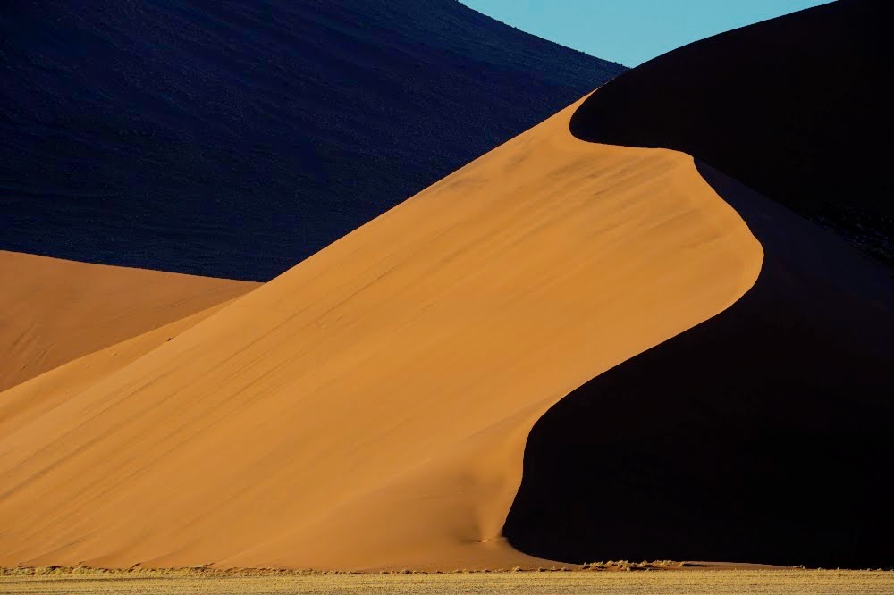
I am also lucky to have a cadre of former students who also travel a lot, and some of them get to places I could not reach myself. For instance, one of my former students was on the logistical crew of an Everest expedition a year or two ago, and he brought back a few precious stones from high on the mountain. And then there are Noel and Art, a couple who are spending their time in Nepal and Africa. This week Art sent me a beautiful collection of photographs from their exploration of Namib-Naukluft National Park in Namibia. So today, I join you as an armchair geologist, enjoying the scenes of an incredible place in a far-flung location of our planet.
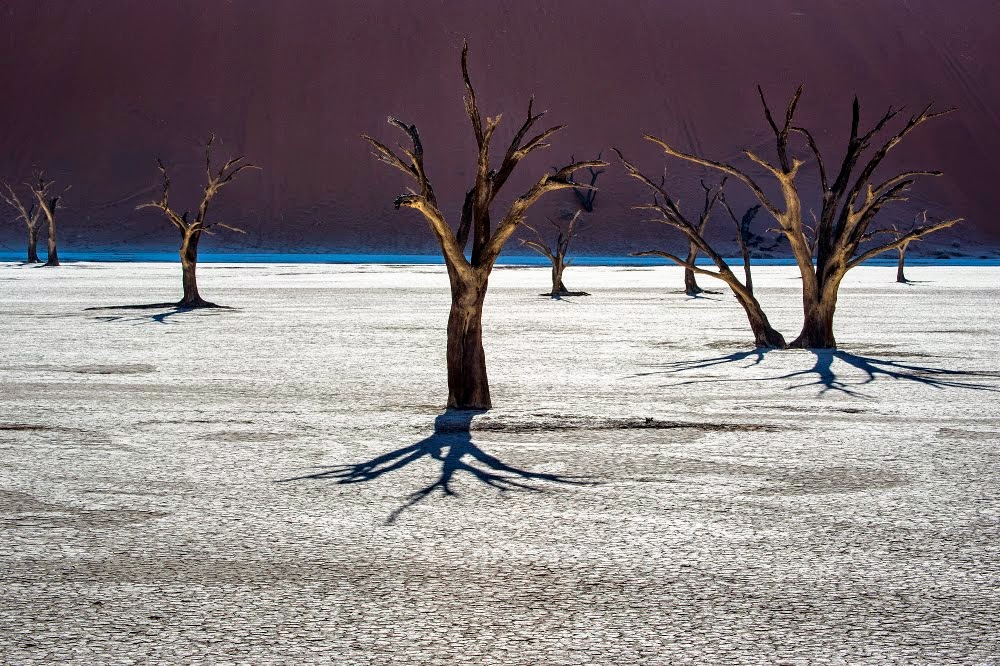
Deadvlei, a former oasis in Namib-Naukluft National Park. The dead trees are acacias.

Namib-Naukluft National Park encompasses just over 19,000 square miles, an area larger than Switzerland, or for you Californians, the area of about 18 Yosemite National Parks. It's the fourth largest national park in the world. It preserves the Naukluft Mountains and a vast region of sand dunes.
The main visitor destination in Namib-Naukluft National Park is Sossuslvei, a portion of the dune field that includes playas and an almost always dry river channel. In the Google Earth image above, on can see the light-colored playas (dry lakes), and the dry channel to the right. One of the world's tallest sand dune can be seen in the area. It's called (very imaginatively) Dune 7. It is 1,256 feet high (383 meters).
The second Google Earth provides a regional context (Sossusvlei is on the bottom of the image on the left side; it is the long narrow gray area). The north-south length of the map is around 150 miles. Namibia is on the west coast of South Africa, and it was part of South Africa until 1990, when the country became independent. The region has been a desert region for tens of million of years, which explains the wide distribution of the sand deposits. The sand is carried into the region along the coastline, and constant onshore winds blow the sand inland. The orange area on the left next to the coast is the vast north end of the dune field.

The Namibian desert is one of the driest in the world. It is dry because of a cold ocean current offshore that prevents the evaporation of water and causes the condensation of the atmospheric water offshore. Sometimes the fog will come onshore, providing a bit of moisture, but generally it is as dry as any place in the world except for some parts of the Atacama Desert in South America. Death Valley in California is practically humid in comparison.
The desert is described as one of the oldest in the world, dating back tens of millions of years. Contrast this with the Mojave Desert and Death Valley, which have existed as deserts for only 2-4 million years, with wet climates during the occasional ice ages.


The source of all the sand in the Namib is the coastline of the Atlantic Ocean. Rivers provide sand to  the coast and longshore currents and beach drift move the sand into the desert shoreline. The onshore breezes carry the sand inland.
There are several kinds of dunes, based on the amount of available sand, and the variability of wind directions over the course of the year. Many of the dunes of the Namib desert are seif (or longitudinal) dunes, long parallel ridges of sand that extend for many tens of miles. When the dunes get backed up against a mountain range, they will have a much more irregular outline that sometimes resembles a starfish. They are called star dunes. Such dunes can accumulate vast amounts of sand and grow to great heights.


Deadvlei is one of the most popular photography spots in the park. The barren dead acacia trees were once watered by an ephemeral stream that changed course. Some of the dead trees may be hundreds of years old.

Dunes move when sand is carried from the base of the windward side and dropped down the lee slope, called the slipface. The dunes will migrate until they reach mountain ridges that interrupt the winds.

Many of the park visitors elect to do a flyover of the park. The vastness and loneliness of this landscape is overwhelming. I would not want to be lost here.

One section of the park contains exposures of a much older example of sand dunes. The billion year old rocks display the same kind of cross-bedding (diagonal layers representing the buried slip-face of dunes) that the modern day desert dunes possess. It's a marvelous example of uniformitarianism, the idea that processes that we can observe happening today also happened in the past (because the laws governing nature have not changed with time).
Many thanks to Art and Noel for sharing these wonderful photographs! Please regard them as copyrighted, however. I think they won't mind if the shots are used in school projects and the like, but if you want to use them in any formal publications, please notify me and I will forward their contact information.

Wednesday, March 18, 2015

Another Cool California Roadcut: Dike and Sill on Highway 190 near Panamint Springs

Dike (vertical brown rock) and sill (horizontal brown rock) along Highway 190 near Panamint Springs
I've been working through my memories of beautifully instructive roadcuts in California. Some, like the Big Pumice Cut and the Charlie Brown Outcrop, are quite famous to geologists and generations of field studies students. Others have received less attention, and today I'm showing a particularly nice spot to learn about the difference between a dike and a sill.

A dike is an intrusion of molten rock that is tabular (thin, but deep and wide, as it fills fractures in the rock), and discordant (it cuts across rock layers). A sill is also tabular, but it is concordant, meaning it squeezes between layers rather than cutting across like a dike.

Highway 190 provides access to Death Valley National Park from the west at Lone Pine and Olancha. It travels around the south edge of Owens Lake, and then crosses the Darwin Plateau before beginning a steep descent into the Panamint Valley. From there it crosses the Panamint Mountains at Townes Pass and enters into Death Valley.
The Darwin Plateau is capped with multiple layers of basaltic rock covering a sequence of Paleozoic limestone layers. Midway down the stretch between the turnoff to Darwin and the resort of Panamint Springs there is a spectacular exposure of a dike and a sill in the same roadcut. The basaltic intrusion has been weathered to an orange-brown color. The Paleozoic-aged limestone is gray and has clearly delineated layering that makes it a straightforward exercise to distinguish the two types of intrusions that cut through it.
I wish I could say that this is a favorite stop on our way to Death Valley, but unfortunately we are usually running late by the time we reach it late in the afternoon on our way to Stovepipe Wells. It is a marvelous example of both kinds of intrusions.

Tuesday, March 17, 2015

The Community Hates Science SO MUCH (not). A Weekend at the Mineral Show

As we all know, science has no hold on the imagination of the young and old in our society, nobody cares about rocks, minerals, fossils, and all that stuff. I mean, one could offer a show with that stuff, and we simply realize that no one would show up.

Or maybe not. Every year, events seem to prove the opposite. For many years, our local Mother Lode Mineral Society has held their Rock and Mineral Show at the Stanislaus County Fairgrounds in Turlock and did so this last weekend. Thousands of community members, old, young, and in-between, showed up, as they always do. If you follow these sorts of things, you can imagine that there are lots of concessionaires hawking their wares, and you'd get the feel that the whole thing is a gigantic sales event. And if they're just selling stuff, why even show up?
The Modesto Junior College Geology Club displays fossil replicas of previous inhabitants of our Great Valley
But the Turlock show is special and different. They devote a huge amount of space for education. There are dozens and dozens of wonderful displays of all aspects of earth science, including paleontology, minerals, rocks, mining, and environment. They make a point of inviting related groups to put up tables, including our new Great Valley Museum, the Geology Club at Modesto Junior College, and many others. They have excellent speakers on numerous topics. The kids who attend, parents and grandparents in tow, have a great time. They are fascinated to find out tidbits of information about their home environment, including the fact that Mosasaurs, dinosaurs, wooly mammoths, giant Short-faced Bears, and many other creatures used to live here at different times in the past.
Coelacanth fossil
We have some serious fans of paleontology in our area, and every year brings some new discovery. They had a Coelacanth display with seven different species of this ancient fish that was a precursor to the amphibians (they had lobed fins instead of rayed fins; their bottom-crawling lifestyle led to legs later on). I don't think I've seen that many in one place in any museum.
Dunkleosteus and a Coelacanth, two ancient orders of the fish family. Dunkleosteus grew to a length of thirty feet or more. The Coelacanths, thought extinct until one was discovered in 1938, is one of the rarest orders of fish in the world.
After seeing all the cool displays, a lot of people end up hoping to secure some samples of their own, and the concessions seem to do good business. I would never fall for any sales ploys, of course.
Or not. I ended up with a beautiful piece of laboradorite feldspar with its iridescent blue sheen, a nice rhombohedral cleavage fragment of orange/gold calcite, and my favorite item, the tooth of a juvenile Wooly Mammoth. All for their educational value, of course.

Sunday, March 15, 2015

What are the Most Important Geologic Roadcuts in California? A Candidate in Coulterville

In a recent post, I explored the geology of the Charlie Brown outcrop. It included excellent examples of normal faults, welded tuff, and airfall tuff, features that served as a microcosm of the geology of the entire province. I was on a field trip this weekend and saw another famous roadcut that encapsulates the geology of a different region. It was the Coulterville exposure of the Mother Lode quartz veins. It can be seen a few hundred feet west of the main junction in the village on Highway 132.
Despite extending for more than a hundred miles through the western Sierra Nevada foothills, the quartz veins of the Mother Lode are surprisingly hard to see in detail. In many places the rock has simply been removed by mining. In other instances the veins are on private property and are not accessible. But in Coulterville, the full extent of the minerals and faults of the Mother Lode are wonderfully exposed.

During the Jurassic Period, a vast subduction zone formed the margin of the western edge of the North American continent. Oceanic crust was being driven downward into the mantle, where parts of it melted to form granitic intrusions. In the Cretaceous, the focus of subduction moved west to where the Coast Ranges are today. The old subduction zone provided an avenue for mineralized solutions to rise towards the surface, where they precipitated quartz and metal deposits including gold and copper. The Melones fault was part of this system of fractures, and runs from Mariposa to Sierra City. Much of the Gold Rush gold was found in the vicinity of this fault zone. Highway 49 follows closely along the trace of the fault as well.
Mariposite at the Coulterville roadcut
The outcrop at Coulterville is the boundary between two terranes, bits of crust that were carried across the Pacific and added to the edge of the continent. The Calaveras Complex lies east of the fault, and the Foothills Terrane is found to the west. The fault zone exposes quartz veins, pyrite, and a unique mineral assemblage of quartz, ankerite, and mariposite. The ankerite is an iron-magnesium carbonate mineral similar to dolomite. The mariposite is an exceedingly rare mineral elsewhere in the world, but is found at many sites along the Melones fault. It is a chrome mica mineral formed when serpentine rock was altered by hot fluids moving up through the fault system. It was a good indicator of possible gold mineralization.
So, I'm wondering what your candidates are for the most significant geological roadcuts in California? I've reviewed the Charlie Brown outcrop, and the Big Pumice Cut that was critical to understanding the age relationships between the glacial tills and volcanic deposits in the eastern Sierra Nevada. I imagine the spectacular folded beds adjacent to the San Andreas fault along Highway 14 in Palmdale might be included. What others would you suggest?

Saturday, March 14, 2015

A Brief Season of Hope, But Dashed Hopes for a Better Year. Some Thoughts on the California Drought

It's such a beautiful moment in time, being able to travel through the Sierra Nevada foothills, and seeing the glorious splash of color across the hillsides. The flower show was among the best I've seen in years.
It wasn't necessarily good that we were seeing such a show. The green hills and flowers give the impression of something approaching a normal precipitation year. Unfortunately it is an illusion. We are in deep, deep trouble.

We are on track in the Sierra foothills and Great Valley to end up with near-normal rainfall totals. But the score was padded in December with a record storm that dropped 7 to 10 inches of rain. It was enough to build up the moisture in the soil, and cause the flower seeds to germinate. The driest January ever recorded followed, and the dry conditions threatened the sprouting flowers. But one intense storm in February boosted their growth. There was just a bit more precipitation this week. Just barely enough to keep things green a little longer.
But it doesn't matter what happens in the Great Valley or the Sierra Foothills. The green grass is a temporary boon for the cattle ranchers, but the all-important snowpack is dismal. It's worse than worse, because last year was the worst, and this year is worser still. As in record low, around 19% of normal. The big storms of December didn't add anything to the snow totals. They were warm storms.
So the hills were green, and we had a glorious day, even if the students had to take notes on their field trip. But one of our last stops put everything in perspective...
Don Pedro Reservoir on the Tuolumne River out of Yosemite Valley looked like this. The reservoir is only 44% full as of today (about 880,000 acre feet out of about 2,030,000 acre feet), a time when it should be rising fast from snowmelt. And Don Pedro is doing better than many reservoirs around the state. Lake McClure on the Merced River is at 8.5% of capacity, just 88,000 acre feet out of 1,030,000 acre feet. According to NASA, the state has one year of water left if the drought doesn't break, and the weather is showing few signs of cooperating. There is no rain on the immediate horizon.
What happens next? How do we deal with record temperatures, record low snowpack, and a declining groundwater resource? The best some can do is to put up signs saying "pray for rain". It hasn't worked. And the farmers are not seeing things realistically. They are blaming measures to protect fish for their problems, but fish or birds aren't the problem. Distributing that little bit of water won't make any difference, except for the handful of lucky farmers who know people, and can get the water allotted to them. They are in denial that there is a serious problem and continue to put in thousands of acres of almond orchards in the foothills, a place where only groundwater is available. The shallow aquifers in the foothill belt will only last a few years if feeding the water-thirsty trees.

I can only see putting a moratorium on the planting of water-gorging trees, and letting more lands lie fallow. The state needs a groundwater policy as well, and giving it regulatory teeth. We need to take a hard look at fracking and the waste water it produces. And everyone needs to cut back on their water use. A lot. Farmers as well as domestic users.

What do you think can be done if next year is a continuation of the dry conditions?

Friday, March 13, 2015

A Roadcut as a Microcosm of a Province - The Charlie Brown Outcrop


A lot of geologic knowledge is gleaned from roadcuts. In less arid regions, vegetation and soil cover is so thick that roadcuts provide essentially the only information about the underlying geology. That isn't as much of a problem in the Basin and Range Province of Nevada, eastern California, and western Utah. It's a dry land, and the rocks stand out in bold relief. And with flat valley floors, roads don't need to be carved through solid rock all that often. But sometimes roads have to cross the mountain ranges, and there they are. A peek at the interior of a mountain range.
Some outcrops are more instructive than others, and once in a while, a road crew uncovers something spectacular. That's what happened when Highway 178, the Charles Brown Highway, was constructed over the Resting Springs Range from Shoshone, California to Pahrump, Nevada. It's about three or four miles east of Shoshone, and you can hardly miss it. There is a huge black "thing" climbing the slope that grabs your attention, and brings any geologist's foot down on the brakes. Caltrans has kindly provided a wide turnout, no doubt because of the congestion that occurs here during field studies season.
The view from the pullout takes in a broken land, as Professor Frank DeCourten has called it. The tan hills of the Resting Spring Range lie in foreground. Across the Amargosa "River" Valley is another ridge of twisted and broken rock, the Amargosa Range, then the Greenwaters, and on the skyline, the Black Mountains. Beyond lies the deep trough of Death Valley. This is a land with a violent history that has included dozens, if not hundreds of astoundingly huge volcanic eruptions, any one of which, if they happened today, could bring about the end of human civilization (through the disruption of agricultural production). The land was stretched until the crust snapped and huge fault systems developed, with deep fault valleys (grabens) and high mountain ranges (horsts). Whatever river systems existed were disrupted (one of them may have been the ancestral Colorado River). Today, even if there were water to flow, none would flow to the sea. The rivers would end in the adjacent valley, forming large lakes.

The Charlie Brown Outcrop, as it is informally known, encapsulates many elements of the story.
There are really three stories told in this exposure, that of distant ash eruptions, a violent eruption close by, and earthquakes with associated mountain-building.

Distant ash explosions sent clouds of pulverized pumice shards that landed in lake beds and valley bottoms. The exposures took various hues due to oxidation of metals, mostly iron, in the ash beds. When major fault systems broke up the landscape, many smaller subsidiary faults shifted a few inches or feet. The ash beds and faults are nicely exposed on the right side of the outcrop. Pictures of this fault grace many geology textbooks.

The dark layer also tells of violent events. A nearby ash eruption produced very hot clouds of incandescent rock particles that landed in a thick layer, and remelted. Such rocks are called welded tuff or ignimbrite. The black layer is the most completely melted rock, and is called a vitrophyre. In essence it is obsidian, but not of a quality that one would want to make arrowheads with.
Photo by Mrs. Geotripper
It's all quite a puzzle for our field students who are seeing these kinds of features for the first time. We introduce the classification of faults, talk a bit about pyroclastic rocks, and then they sketch out the relationships that they can see. They give their best interpretation of what happened here, and the nice thing is, a lot of them find out that they can do a pretty fair job of discerning the story revealed by the rocks.

The idea of calling this the story of the Basin and Range in a roadcut was most assuredly not my idea. It comes from a short study of the rocks by Bennie Troxel and E. Heydari in 1982:

Troxel, B. W., and Heydari, E., 1982, Basin and Range geology in a road cut, in Cooper, J. D., Troxel, B. W., and Wright, L. A., eds., Geology of selected areas in the San Bernardino Mountains, western Mojave Desert and southern Great Basin, California: Geological Society of America, Guidebook, p. 91 – 96.