I don't think there's anything nicer for a teacher of the earth sciences than to have a classroom in the outdoors. The planet is always around us and to step outside a classroom is to step outside of book learning and theoretical constructs, and into the actual chemical and physical reactions that affect every aspect of our lives. Yes, there is always gravity, and we are always respirating whether we are indoors or out, but there is nothing quite like being right on top of the volcanoes or the faults that can cause geological mayhem. We can tell the story of how rocks and mountains and continents came into being, but it is something else entirely to stand on the rocks that actually tell us the story step by step. There is just no substitute for field experience in a geology class.
So here is our class sitting in the midst of one of the greatest geological parks in the world, Death Valley. Rocks from nearly all the periods and eras of the geological time scale can be found within the boundaries of the park, and the park includes some of the oldest rocks in western North America (one has to get to Montana and Wyoming to find rocks that are older). They are quite literally sitting on the trace of a major fault line, and the darker slope on the left is a small volcanic cone that erupted along the fault. It's all the geological mayhem in one spot than anyone could ask for!
We had spent the day working our way through geological time, with a stop at a roadcut containing Miocene tuff and examples of faulting, a stop on the alluvial fan below a mountain of Paleozoic-aged fossil bearing limestone, and an exploration of a former rift valley containing late Proterozoic sediments. We had now reached the base of the Black Mountains of Death Valley, the deepest crustal rocks exposed anywhere in the park. They are exposed here because extreme extensional forces have ripped the crust apart, and the deep trough of Death Valley gives us a peek into the deeper parts of the continent. These are rocks from the early Proterozoic around 1.7 billion years ago. The radiometric age date of 1.7 billion years records the time that these rocks were metamorphosed, so the actual age of the protoliths (the original rock before metamorphism) is millions of years older still. There are hints of rocks and detrital grains (the Mojave Block) that may be as old 2.3 billion years, more than half the age of the Earth.
A look at the rocks where they spilled out onto the valley floor offers a hint of the massive changes these rocks have experienced. They are composed of gneiss and schist, rocks that normally develop in regions of extreme temperature and pressure deep in the crust. About the only geological circumstance in which such conditions occur are in places where continents or exotic terranes are colliding with each other, in the way that India is colliding with Asia today to form the Himalaya Mountains. Such a mountain range once existed right here. And it eroded away, almost completely. Then, the continent split, and a portion of the ancient mountain range rifted away to become part of Australia and/or Antarctica. The remainder of the rocks were buried under tens of thousands of feet of younger sediments during the Paleozoic era. And there they remained for several hundred million years.
It wasn't until intense extensional forces ripped the crust apart, causing the graben of Death Valley to sink and form the imposing western face of the Black Mountains. As the mass of the overlying rocks slid off the deeper crustal rocks, the deep rocks domed upwards to form the curving footwall of the strange "turtlebacks" of Death Valley. In other words, the roots of an ancient mountain range rose to form the core of a modern day range, the Black Mountains: mountains hidden with mountains.
And the drama was visible within the rocks we were sitting on. It was a most amazing classroom!
Thursday, March 20, 2014
Tuesday, March 18, 2014
Vagabonding Across the Colorado Plateau: Join Geotripper and the AAPG on May 31-June 6, 2014!
![]() |
| Antelope Canyon, on the Navajo Reservation near Page, Arizona |
The Colorado Plateau, the region encompassing large parts of Arizona, Utah, New Mexico and Colorado, is one of the great geologic showplaces on planet Earth. Within the region, one can see in vivid colorful detail nearly two billion years of Earth history, from the ancient Proterozoic crust exposed at the bottom of the Grand Canyon to the Cenozoic lake sediments that formed the strange hoodoos of Bryce Canyon. The plateau country has been central to many of my blogs over the last five years, including three major series: Time Beyond Imagining, Vagabonding Across the 39th Parallel, and The Abandoned Lands (I'm also slowly working on the latest, America's Never-Never). In addition to being a bountiful source of information about the past, it is one of the most beautiful landscapes in the world.
![]() |
| The Great Unconformity, the erosional boundary between the Proterozoic rocks of the Yavapai Orogeny and the Cambrian Tonto Group exposed in Diamond Creek on the Hualapai Reservation. |
![]() |
| The Colorado River at Diamond Creek on the Hualapai Reservation |
From Kingman, we will head northeast on the longest remaining stretch of Route 66 to Peach Springs. At this point we expect to make our way down Diamond Creek, the only place where one can drive to the bottom of the Grand Canyon. We will have a close look at the Proterozoic and lower Paleozoic rocks of the canyon, formations not easily accessed in most parts of the Grand Canyon. If we are lucky, we may run across a herd of bighorn sheep.
We will then drive to the south rim of Grand Canyon, and spend a day exploring one of the most spectacular gorges in existence. Some free time will be available for a hike into the canyon, or for an optional canyon overflight. Relatively short (but steep) hikes from the rim provide access to the upper Paleozoic rocks of the plateau country, such as the Coconino Sandstone, Toroweap Formation, and Kaibab Limestone.
The following day we will work our way east to the canyon of the Little Colorado River and the Navajo Reservation. We will be exploring the Mesozoic formations of the plateau, including the Moenkopi, Chinle, Kayenta, Wingate and Navajo formations. Along the way we will stroll out to Horseshoe Bend on the Colorado River (below) and the incredible Antelope Canyon (the top photo), one of the most dramatic slot canyons to be found anywhere. We will spend a night in Page, Arizona, next to Lake Powell.
![]() |
| Horseshoe Bend on the Colorado River below Glen Canyon Dam. |
![]() |
| The Cockscomb monocline near Kodachrome Basin State Park in Utah. |
From Kodachrome Basin, we will climb through the Cretaceous sediments of the plateau country, including the Tropic Shale and Mesa Verde Group. We will arrive at Bryce Canyon National Park, which exposes one of the youngest formations on the Colorado Plateau, the Claron Formation. The hoodoos of Bryce are some of the most photogenic rocks to be seen anywhere. There will be time to hike below the rim for a completely different perspective on the unusual spires.
Leaving Bryce, we will head south along the Sevier fault and then turn west at Mt. Carmel Junction to drive into Zion National Park. Zion Canyon provides the best possible look at the incredible Navajo Sandstone, a Jurassic deposit that preserves the evidence of a vast sand sea that once covered a large part of the western United States.
Our route will take us on a little-traveled road through the western and northern part of the park to Lava Point. Along the way we will traverse a unique inverted stream, and pass through some rarely seen lava flows and cinder cones.
Leaving Zion, we will head southwest back to Las Vegas.
The guidebook for the trip was written by myself and my son Andrew, an anthropology professor at Modesto Junior College. It includes a great deal of information on the natural and human history of the plateau, as well as the geology.
This is the second time we are making this journey, and we had a great time last year, with a marvelous group of geologists and their families, some of whom traveled from as far away as Australia and Canada. This year's crew looks to be equally international.
There are a host of other wonders along the route! I've been writing about this country for a long time, introducing you, my readers, to one of the most beautiful and geologically rich corners of our planet. We've traveled together in words and pictures, and I would love the opportunity to travel with some of you in person this summer. Join us!
Detailed information and registration forms can be accessed at on the AAPG site (click here) I would be pleased to answer any questions you might have by emailing me at hayesg (at) mjc.edu.
Sunday, March 16, 2014
Out of the Valley of Death: When a Broken-up World Turned to Ice
Our grand exploration of the Valley of Death took us briefly out of the valley itself where we could legally collect some Paleozoic fossils, and to do some training on outcrop interpretation (but no pictures of the Charlie Brown outcrop this year; see this for a previous year's version). We crossed Salsberry Pass at 3,315 feet, drove down a long drainage towards the south end of Death Valley, then turned north and crossed Jubilee Pass at 1,290 feet and drew close to Ashford Mill at sea level.
We were looking for evidence of the cold times in Death Valley. Not the cool times of the last ice age when a freshwater lake filled the valley floor. That was a blink of the eye in geologic time. We were looking at events nearly a billion years ago, when the continents of the world were breaking up, and the surface of the planet nearly froze over. Maybe completely frozen over.
Rodinia was a supercontinent that predated the better known Pangea. The break-up of Rodinia just prior to the beginning of the Paleozoic era heralded the appearance of complex multicelled animals on Earth, and the ragged torn edges of the continent here and there contain evidence of huge changes in world climate. The canyon below Jubilee Pass preserves the remnants a fault-controlled valley that developed along the margin of the newly formed Pacific Ocean and slowly filled with thousands of feet of sediment.
The rocks that filled the rift are collectively called the Pahrump Group, and are divided into three formations, the Crystal Springs Formation, the Beck Springs Dolomite, and the Kingston Peak Formation (oldest to youngest). The older two are interesting because they contain the oldest fossils known from California: structures in the mud that record the daily collection of mud and clay on algal slime that covered pebbles and boulders in a shallow sea that filled the fault trough. The concentrically layered structures are called stromatolites. But the Kingston Peak Formation is strange.
As can be seen in the picture above, the Kingston Peak is composed in large part of conglomerate, a rock with large numbers of boulders, cobbles and pebbles in a matrix of sand and mud. Most conglomerates form in alluvial fans or river channels, and much of the Kingston Peak seems to have formed that way. But some of the boulders show the scratches and grooves that indicate that they were dragged across a hard surface, and some look as if they were dropped into the mud of ocean floor. One of the few situations where this sort of thing happens is when icebergs melt and drop their load of boulders onto the sea floor. Such rocks of possible glacial origin are called diamictites
This would be pretty strange because the presence of carbonate rocks in the adjacent layers and reconstructions of continental distribution at the time suggests the Kingston was deposited in tropical or equatorial regions. No glacial episode in the last 500 million years covered that much of the planet. Not even close. It could be that these rocks at Death Valley formed in some other way, such as extensive mudflows or some other explanation. It's just that such diamictites have now been found at a few dozen places around the world, and that can't be ignored as a local circumstance. It looks like the Earth froze over around 700-800 million years ago. All the way from the poles to near the equator.
How could life on Earth survive such a calamity? Environmental refuges probably existed in the shallow oceans beneath the ice - cold, but not solid ice. Warm chemical-rich water could have been found in the hot springs around the mid-ocean ridges. There may have been freshwater lakes under the glacial ice. In any case, life had to adapt or die, and one of the strategies that evolved may have been multicellular organization and formation of tissues and organs. All complex life on the planet today may owe its existence to the "Snowball Earth".
The concept of a "snowball Earth" must still be considered an hypothesis. Although the glacial episode most certainly took place, many researchers feel that a strip of open ocean still persisted near the equator. Those details remain to be worked out. But on this day, we had a chance to walk across rocks that formed in a time when the Earth turned cold. Very, very cold. And we were observing those rocks from the hottest and nearly the driest place on Earth today.
We walked up a valley eroded along the boundary between the Beck Springs and the Kingston Peak Formations, and walked onto a ridge with a stunning view of the south end of the Death Valley graben. The high ridge of the Panamint Mountains rose in the distance. In the foreground was a black hill called Shoreline Butte, which would be our next stop. It was an incredible view, and it was an incredible story that was told by the rocks beneath our feet. We hiked back to the vehicles and headed up the road to Badwater.
We were looking for evidence of the cold times in Death Valley. Not the cool times of the last ice age when a freshwater lake filled the valley floor. That was a blink of the eye in geologic time. We were looking at events nearly a billion years ago, when the continents of the world were breaking up, and the surface of the planet nearly froze over. Maybe completely frozen over.
Rodinia was a supercontinent that predated the better known Pangea. The break-up of Rodinia just prior to the beginning of the Paleozoic era heralded the appearance of complex multicelled animals on Earth, and the ragged torn edges of the continent here and there contain evidence of huge changes in world climate. The canyon below Jubilee Pass preserves the remnants a fault-controlled valley that developed along the margin of the newly formed Pacific Ocean and slowly filled with thousands of feet of sediment.
The rocks that filled the rift are collectively called the Pahrump Group, and are divided into three formations, the Crystal Springs Formation, the Beck Springs Dolomite, and the Kingston Peak Formation (oldest to youngest). The older two are interesting because they contain the oldest fossils known from California: structures in the mud that record the daily collection of mud and clay on algal slime that covered pebbles and boulders in a shallow sea that filled the fault trough. The concentrically layered structures are called stromatolites. But the Kingston Peak Formation is strange.
As can be seen in the picture above, the Kingston Peak is composed in large part of conglomerate, a rock with large numbers of boulders, cobbles and pebbles in a matrix of sand and mud. Most conglomerates form in alluvial fans or river channels, and much of the Kingston Peak seems to have formed that way. But some of the boulders show the scratches and grooves that indicate that they were dragged across a hard surface, and some look as if they were dropped into the mud of ocean floor. One of the few situations where this sort of thing happens is when icebergs melt and drop their load of boulders onto the sea floor. Such rocks of possible glacial origin are called diamictites
This would be pretty strange because the presence of carbonate rocks in the adjacent layers and reconstructions of continental distribution at the time suggests the Kingston was deposited in tropical or equatorial regions. No glacial episode in the last 500 million years covered that much of the planet. Not even close. It could be that these rocks at Death Valley formed in some other way, such as extensive mudflows or some other explanation. It's just that such diamictites have now been found at a few dozen places around the world, and that can't be ignored as a local circumstance. It looks like the Earth froze over around 700-800 million years ago. All the way from the poles to near the equator.
How could life on Earth survive such a calamity? Environmental refuges probably existed in the shallow oceans beneath the ice - cold, but not solid ice. Warm chemical-rich water could have been found in the hot springs around the mid-ocean ridges. There may have been freshwater lakes under the glacial ice. In any case, life had to adapt or die, and one of the strategies that evolved may have been multicellular organization and formation of tissues and organs. All complex life on the planet today may owe its existence to the "Snowball Earth".
The concept of a "snowball Earth" must still be considered an hypothesis. Although the glacial episode most certainly took place, many researchers feel that a strip of open ocean still persisted near the equator. Those details remain to be worked out. But on this day, we had a chance to walk across rocks that formed in a time when the Earth turned cold. Very, very cold. And we were observing those rocks from the hottest and nearly the driest place on Earth today.
We walked up a valley eroded along the boundary between the Beck Springs and the Kingston Peak Formations, and walked onto a ridge with a stunning view of the south end of the Death Valley graben. The high ridge of the Panamint Mountains rose in the distance. In the foreground was a black hill called Shoreline Butte, which would be our next stop. It was an incredible view, and it was an incredible story that was told by the rocks beneath our feet. We hiked back to the vehicles and headed up the road to Badwater.
Saturday, March 15, 2014
Mima Mounds in Merced County
We were on the road today with some students, exploring the southern end of the California Mother Lode, the site of the 1848 Gold Rush. One of the first things we saw as we approached the Sierra Nevada Foothills were the enigmatic features called mima mounds.
I talked about mima mounds a few months ago, with pictures from Stanislaus county, Yokohl Valley, Tehachapi, and even their most famous site, the Mima Mounds south of Seattle and Tacoma. But someone asked at the time if I had pictures of the ones just south of where I live, which I have driven past many dozens of times, and I realized I had never photographed them. They lie south and west of Hornitos Road on the prairie lands east of the valley town of Merced. I almost missed them again today as we started on our field studies class, but I grabbed the camera just in time to snap a few shots as we sped by.
The mounds have been attributed to Native American burials, earthquake waves and other complicated causes, but the latest research suggest that thousands of generations of gophers produced them. Maybe not the most fun of explanations, but the most satisfying as far as I am concerned.
There were quite a few sights on the road today, more on them in other posts!
I talked about mima mounds a few months ago, with pictures from Stanislaus county, Yokohl Valley, Tehachapi, and even their most famous site, the Mima Mounds south of Seattle and Tacoma. But someone asked at the time if I had pictures of the ones just south of where I live, which I have driven past many dozens of times, and I realized I had never photographed them. They lie south and west of Hornitos Road on the prairie lands east of the valley town of Merced. I almost missed them again today as we started on our field studies class, but I grabbed the camera just in time to snap a few shots as we sped by.
The mounds have been attributed to Native American burials, earthquake waves and other complicated causes, but the latest research suggest that thousands of generations of gophers produced them. Maybe not the most fun of explanations, but the most satisfying as far as I am concerned.
There were quite a few sights on the road today, more on them in other posts!
Labels:
Hornitos,
Merced,
mima mounds,
Sierra Nevada foothills
Thursday, March 13, 2014
Out of the Valley of Death: Mountains and Mountains of Animals
So many colors in a desert environment! It was the second morning of our trip into the Valley of Death, or Death Valley National Park as others call it. On the previous day we had made our way across the southern end of the Sierra Nevada after searching for shark tooth fossils in the dusty hills near Bakersfield. We then crossed the Garlock fault at Red Rock Canyon State Park and drove north into the Owens Valley and looked at the dry water course at Fossil Falls. Late in the day we had forced passage over two mountain ranges, the Darwin Plateau at the south end of Inyo Mountains, and the Panamint Mountains. Of course, passing over mountain ranges in the modern day is a great deal less difficult than it used to be.
We set up camp in the dark, and so had no idea the scene that would greet us in the morning light. It was glorious. There was movement in the camp as the students started waking up and looking around. It was going to be an interesting day.
There was a storm brewing out in the Pacific Ocean, and I was sure we were going to catch a corner of it, but storms come to die in Death Valley just as surely as the dreams of avarice in the eyes of miners wither in the face of the desert heat. All we could see of the weather disturbance were the high clouds drifting above.
Few of the original settlers who were trapped in Death Valley and gave it the name actually died. On the other hand, the mountains that surround the valley are full of death, in a way. For several hundred million years the region that is today Death Valley was a passive continental margin on the edge of the (much smaller) North American continent. Rivers carried some sediment into deltas that connected to the shelf, but mostly in the tropical conditions limestone formed, more often than not as the result of organic activity. As organisms died, their shells became incorporated into the limestone layers that dominate mountain ranges surrounding Death Valley. The formations ultimately reached a thickness of at least 20,000 feet. There are mountains of animals!
Erosion has ripped away the rocks and deposited them in widespread alluvial fans, and the remains of the ancient creatures can be viewed in the rocky detritus. The students were interested in searching for them. The urge to collect can be powerful, and that's illegal in a national park, so we headed east towards the park boundary on the road to the Amargosa Valley and Death Valley Junction. When we stopped, the students scattered across the desert, not finding much at first, but soon there were cries of discovery. Horn corals (below), crinoid or blastoid columns (the next picture after), brachiopods, bryozoans, gastropods, and even an occasional cephalopod.
Some of the samples were quite showy!
Occasionally I looked up towards the forbidding peaks of the Funeral Mountains and contemplated how many creatures lived, struggled and died to make up the many thousands of feet of carbonate rock in the slopes above. Untold trillions...
We set up camp in the dark, and so had no idea the scene that would greet us in the morning light. It was glorious. There was movement in the camp as the students started waking up and looking around. It was going to be an interesting day.
There was a storm brewing out in the Pacific Ocean, and I was sure we were going to catch a corner of it, but storms come to die in Death Valley just as surely as the dreams of avarice in the eyes of miners wither in the face of the desert heat. All we could see of the weather disturbance were the high clouds drifting above.
Few of the original settlers who were trapped in Death Valley and gave it the name actually died. On the other hand, the mountains that surround the valley are full of death, in a way. For several hundred million years the region that is today Death Valley was a passive continental margin on the edge of the (much smaller) North American continent. Rivers carried some sediment into deltas that connected to the shelf, but mostly in the tropical conditions limestone formed, more often than not as the result of organic activity. As organisms died, their shells became incorporated into the limestone layers that dominate mountain ranges surrounding Death Valley. The formations ultimately reached a thickness of at least 20,000 feet. There are mountains of animals!
Erosion has ripped away the rocks and deposited them in widespread alluvial fans, and the remains of the ancient creatures can be viewed in the rocky detritus. The students were interested in searching for them. The urge to collect can be powerful, and that's illegal in a national park, so we headed east towards the park boundary on the road to the Amargosa Valley and Death Valley Junction. When we stopped, the students scattered across the desert, not finding much at first, but soon there were cries of discovery. Horn corals (below), crinoid or blastoid columns (the next picture after), brachiopods, bryozoans, gastropods, and even an occasional cephalopod.
Some of the samples were quite showy!
Occasionally I looked up towards the forbidding peaks of the Funeral Mountains and contemplated how many creatures lived, struggled and died to make up the many thousands of feet of carbonate rock in the slopes above. Untold trillions...
Tuesday, March 11, 2014
California's 6.9 Magnitude as Recorded at Modesto Junior College
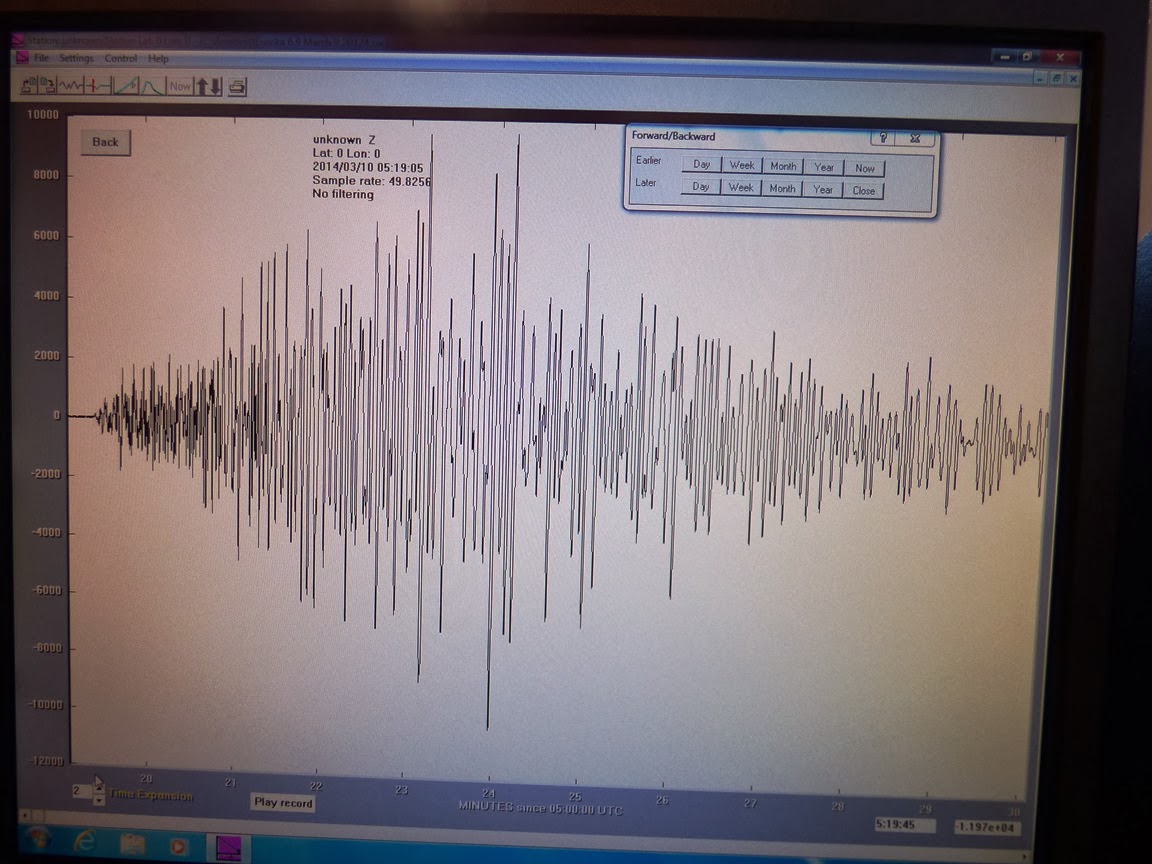
Here is California's 6.9 magnitude earthquake from last Sunday as recorded on our rather simple seismometer situated on the West Campus of Modesto Junior College. The unit is up on the third floor of the new Science Community Center, which is not ideal from a recording standpoint (the building is subject to all kinds of vibrations), but it's wonderful as an educational tool. We have one of the monitors up against a window where students can check for earthquake activity (and of course jump up and down to make their own earthquakes). The activity across the bottom of the record is the vibration of students walking by on Monday morning. This is the first major seismic event that we've recorded since installing the unit.
The horizontal lines on the monitor represent one hour increments, so the whole screen covers about 24 hours. The quake happened at 10:18 PM local time, and the shaking lasted for a good fifteen minutes. This doesn't mean that people were being shaken the whole time, because the actual humanly perceived shaking lasted only about 15 seconds. Instead, the ground continued to reverberate more slowly, so the movement was imperceptible. The waves would have continued all over the world and through the planet as well. They would have been detectable on a seismometer in India or Africa.
Here is the isolated and expanded version of the event. It covers about eleven minutes of the shaking:
Science in the 5th Dirtiest Town in the Nation: I'm Proud of my Community and Its Support for Education
![]() |
| Source: http://www.forbes.com/pictures/mef45ilmk/5-modesto-calif/ |
I know that journalism has to work this way, so Forbes picked the picture above to show just how lousy our town is. To hell with them...I have a different image of Modesto, and it has to do with the spirit of our community...and science.
You may have seen my last post about science in our community, our recent Science Olympiad, and the incredible Science Community Center on our campus that OUR community decided to build, without state or federal support. They wouldn't have given it anyway, so we did it ourselves. And our community is responding to the wonderful opportunities it offers. Two more events crystallized my opinion towards Forbes this weekend. Take a look at the photos below:
You are looking at the Mother Lode Mineral Society's Gem and Mineral Show, conducted last weekend in Turlock, our fellow city to the south. Mineral shows can be held in some disdain by geoscientists, as they usually are composed of nothing but a bunch of booths offering merchandise for sale. It's all about sales and capitalism. But not ours. Widely recognized as one of the best mineral shows in California, it stands apart because of the emphasis on education. Yes, rock and mineral businesses are there offering their wares, but fully a third (I'm guessing) of the floor space is taken up by displays, and by booths offering information about earth science issues and concerns.
Our campus geology club participated for the first time this year, and we had a great time giving away fossils to children (those are Cretaceous-aged oysters from Utah). It's amazing to watch a child's eyes light up when they realize they get to have a genuine fossil of their own. We also had dinosaur bones set out, and some fossil skull replicas of the interesting creatures that used to live in our own valley: a Sabertooth Cat , and a Short-faced Bear. The cat is certainly interesting, but the bear is awesome. It may have been the largest land mammal carnivore of all time, standing eleven feet tall. Kids left the show today knowing something very cool about the land they live on!
Other exhibits showed some of the other past denizens of our valley including the Carcharodon megalodon, the largest carnivorous shark of all time, and a plesiosaur. And there were dozens of display cases showing wondrous mineral and rock samples that weren't actually for sale. They were there to educate.
Of course, who would want to show up for an educational thing? In our town? Oh, about 7,000-10,000 people or so. This is one of the largest community events that happens in our town. The local mineral society can be proud of this incredible event!
Really, who else would have a coelacanth is the main display item in the foyer?
Later in the day we headed over to Modesto's State Theatre for the other scientific event of the afternoon. I've been involved for the last two years with the Science on Screen program, which pairs popular theatrical films with speakers and displays amplifying and discussing the scientific issues raised by the film. In the past year and a half, we've shown Jurassic Park, The Day After Tomorrow, Another Earth, Spiderman, and this last weekend, Blue Butterfly.
Once again I was surprised by the crowd waiting outside. Around 150 people came out to see a relatively obscure film from ten years ago about a terminally ill boy who travels to the Central American rainforest, seeking an elusive Blue Morpho Butterfly.
The State is a wonderful 1930s-vintage Art Deco movie theater that survives and thrives on community support. It offers up shows and movies that don't get exposure in the multiplexes at the malls. The Science on Screen Initiative is supported in part by a grant from the Dorothy Sloan Foundation, but it happens because of a group of hard-working volunteers who plan and conduct the programs.
Visitors last Sunday were treated to marvelous displays of tropical butterflies and the equipment used in rainforest research. Prior to the film, one of our local experts, Dr. Derek Madden of Modesto Junior College, talked about his research with monkeys and their relative lack of arthritis when living in the wild.
So, yeah, Modesto is a "dirty" town in the eyes of Forbes. Others call us the worst place in the nation to live. But they could have chosen hundreds of different pictures to represent the spirit of a town. One of the areas where we shine is science education. We are working hard to make our community better, and education is one of the most important tools we have. And our community is clearly responding.
A final (added) thought about those "places rated" that continually put the cities of the San Joaquin Valley at the top of the lists of the worst places to live. The Great Valley of California produces something like 25% of all the food grown in the nation, and that food is kept cheap by exploiting the people who work the fields. We don't have an economic model in our nation that offers employment year-round for such people (we used to simply deport them back to Mexico), so our unemployment is continually high. The plowing of the fields keeps particulate matter in the air, thus our lousy pollution levels. To the Forbes people and others like them who enjoy poking fun at our lousy environment should realize that the cheap food that they eat and the wonderful California wines that they drink come at the expense of the living conditions of those who live in the valley.
Subscribe to:
Posts (Atom)