 It may seem paradoxical to speak of drought in California right now. The snowpack in the Sierra Nevada is running nearly 200% of normal, and farms are receiving the most irrigation water they've seen in years. Yosemite waterfalls are thundering. Yet that is what is happening this week, just as it does every year. The great drying has begun; the subtropical belt of high pressure, which maintains the aridity of places like the Sahara and Australian Outback, is making its presence known here in California. Despite the overwhelming amount of precipitation this last winter, we'll see hardly a drop of rain anytime between now and next October.
Even though the high country is still encased in a mantle of snow, the grass is dying here on the floor of the Central Valley. The low foothills are turning brown, so we headed a little higher, where spring is still happening. Marshes Flat Road climbs out of the Don Pedro Reservoir area onto a resistant ridge of metamorphic rock called the Penon Blanco Volcanics. These rocks formed as volcanic islands in the Pacific Ocean in Jurassic time, and were pushed into the western edge of the North American continent in Cretaceous time and scraped off to become part of what is called the Foothills Terranes. The road reaches elevations of 1,800 feet or so before crossing the ridge into the Mother Lode region at Moccasin.
 The rocks are mostly greenstones, and are shot through with occasional quartz veins, as can be seen in the picture above. Oh wait, is that a flower of some sort? We've discovered spring again! It's moving uphill right now, and will take all summer to reach the alpine peaks at 12,000-13,000 feet. That is certainly the fun of living in this state. Even as the valleys dry out and bake in the dusty heat of summer, the mountains still get a certain amount of orographic (rain shadow) precipitation and remain green through September.
 As I've mentioned before, I have no qualms about making my students learn the names of a couple of dozen minerals, but I have never learned more than a few flower names during my travels. In my own perception, then, I might see flowers every year, but without learning their names, they seem like a new discovery. That's fun in a way, but it is also an appalling form of ignorance, so I'm undertaking a personal project to learn the names and nature of some of the flowers I am seeing this year. So, the hardy succulent in the picture above that survives in the cracks and fractures of solid rock where almost nothing else can grow is a Live-Forever(Dudleya cymosa, corrected with Neil's help). I've seen them before and wondered how they survived, but it seems clear that they store the moisture in their leaves, rather than drawing moisture from the ground.
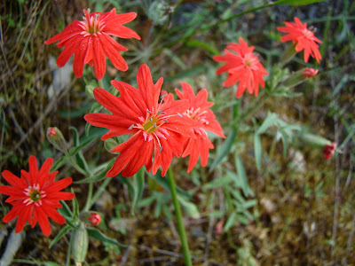
 I'm pretty sure I've never closely observed these striking scarlet colored flowers up close. I suspect that I mistook them for Indian Paintbrush in the past, but a close look this week made it clear that they are something entirely different. These showy flowers are called Indian Pink (Silene californica), or Catchfly, or Campion. None of my internet sites seem clear on why they are called Pinks when they clearly are not. It may refer to the pink at the center of the flower, or that they are part of a family of flowers that include pink varieties. The "Catchfly" name refers to sticky parts of the flower that sometimes traps insects.
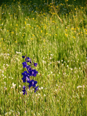
 In a meadow near the summit of Marshes Flat Road, we found a beautiful purple flower that seems to be a Larkspur (Delphinium species). Besides being very obvious, it is also highly poisonous to cattle.
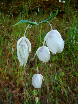
 Another flower that did not seem at all familiar was the White Fairy Lantern (Calochortus albus), which is a member of the lily family. The flowers never really completely open up (gotta make those bugs earn their nectar?).

 I've seen Clover (Trifolium sp) many times in springtime meadows, but I've never really gotten down on the ground to have a closer look.
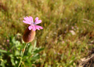
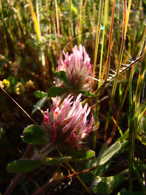 I've also noticed this beautiful small pink flower in the past (below), but never identified it. I was surprised to find it is called Wild Carnation (Petrorhagia dubia). The genus name translates to rock fissure, referring to where some of the species grow. It is actually native to Europe.
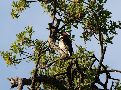
 Of course, flowers aren't the only things we see. The oak trees were bright green, and quite a few Acorn Woodpeckers were flitting about. They didn't pose very nicely for me, but I got one shot that allowed me to identify this shy one.
 As always, being the non-expert botanist, I am open to corrections for any misidentifications! More spring updates as I find excuses to hit the road!
 I'm pretty sure I've never closely observed these striking scarlet colored flowers up close. I suspect that I mistook them for Indian Paintbrush in the past, but a close look this week made it clear that they are something entirely different. These showy flowers are called Indian Pink (Silene californica), or Catchfly, or Campion. None of my internet sites seem clear on why they are called Pinks when they clearly are not. It may refer to the pink at the center of the flower, or that they are part of a family of flowers that include pink varieties. The "Catchfly" name refers to sticky parts of the flower that sometimes traps insects.
 In a meadow near the summit of Marshes Flat Road, we found a beautiful purple flower that seems to be a Larkspur (Delphinium species). Besides being very obvious, it is also highly poisonous to cattle.
 Another flower that did not seem at all familiar was the White Fairy Lantern (Calochortus albus), which is a member of the lily family. The flowers never really completely open up (gotta make those bugs earn their nectar?).
 I've seen Clover (Trifolium sp) many times in springtime meadows, but I've never really gotten down on the ground to have a closer look.
 I've also noticed this beautiful small pink flower in the past (below), but never identified it. I was surprised to find it is called Wild Carnation (Petrorhagia dubia). The genus name translates to rock fissure, referring to where some of the species grow. It is actually native to Europe.
 Of course, flowers aren't the only things we see. The oak trees were bright green, and quite a few Acorn Woodpeckers were flitting about. They didn't pose very nicely for me, but I got one shot that allowed me to identify this shy one.
 As always, being the non-expert botanist, I am open to corrections for any misidentifications! More spring updates as I find excuses to hit the road!


