Showing posts with label Marshes Flat Road. Show all posts

Tuesday, March 25, 2014

Finding Gold in the Mother Lode (but not that kind): A bit of color in drought-stricken California

Our search for gold in the Mother Lode of the Sierra Nevada foothills was successful, but we weren't looking for that kind of gold. Yes, these gentle hills once hosted one of the greatest gold rushes in history, but the mines have been silent for many decades. Today, the Mother Lode is a tourist destination, and one of the attractions is the spring wildflower show. In the last post, we saw how a few endemics are showing up this week on the serpentine soils in the Red Hills Area of Critical Environmental Concern. Serpentine occurs in bands associated with the Melones Fault Zone which divides two major terranes, the Calaveras Complex and the Foothills Terranes. The Mother Lode gold-bearing quartz veins occur along this same boundary.
Highway 49 winds for 150 miles or so along the Mother Lode, and as we saw in the last post, the early flower shows are patchy, and are helped in places by runoff from the asphalt. The hills are green for the moment, but the green will not last long. In most normal years, 90% of the rain has fallen by now, and we have received maybe 25% of the rain we usually expect. It's the worst drought ever recorded. The green grass in these pictures will start turning brown in a few short weeks, and we can look forward to a hot, dry and fiery summer season.
So the early wildflowers are out, and if the expected storm arrives tomorrow, they might receive enough water to last a few more weeks. One thing I know from years of exploring southwest deserts, flowers in a dry place are precious to behold. So enjoy some of the color we discovered last weekend.
 There were occasional patches of Foothills Poppies.
The Redbuds were in bloom, adding bright splotches of purple or pink to the hillsides.
 Lupines seem to do well in lots of environments along the Mother Lode.
These pleasing-looking leaves are not good for touching or picking; this is the ever-present Poison Oak. The leaves are colorful and eye-catching throughout much of the summer season and into the fall.
We reached the Moccasin Creek area and saw where the Marshes Flat Road diverges from Highway 49 and heads west through the metavolcanics and metasedimentary rocks of the Foothills Terranes. These Jurassic rocks were deposited on the sea floor and scraped off into the vast subduction zone complex that once extended from Canada to Mexico and beyond. Today the rocks are tilted to an almost vertical attitude. On the meadowlands around Marshes Flat the rocks are rarely seen, as they are covered with fairly deep soils.
The road is a pleasant backcountry avenue that serves as access for several ranches. It's usually an uncrowded drive.
The metavolcanic rocks show up when the road starts down the steep slopes towards Don Pedro Reservoir. Although there was almost no water in the creeks, some of the slopes had pockets of blooming flowers, including these Shooting Stars.
 If these are Shooting Stars, are the two flowers below star-crossed lovers?
 Near a creek we found some wild onion blooming.
 And a moving rock. Seriously, why is there a track here, and what moved the rock?

We saw that the sun was getting low in the sky, and I had a lot of grading to attend to, so we headed home. I hope the blooms last long enough for another trip before summer sets in!

Thursday, May 5, 2011

The Great Drying Has Begun: Springtime in the Sierra Nevada

It may seem paradoxical to speak of drought in California right now. The snowpack in the Sierra Nevada is running nearly 200% of normal, and farms are receiving the most irrigation water they've seen in years. Yosemite waterfalls are thundering. Yet that is what is happening this week, just as it does every year. The great drying has begun; the subtropical belt of high pressure, which maintains the aridity of places like the Sahara and Australian Outback, is making its presence known here in California. Despite the overwhelming amount of precipitation this last winter, we'll see hardly a drop of rain anytime between now and next October.

Even though the high country is still encased in a mantle of snow, the grass is dying here on the floor of the Central Valley. The low foothills are turning brown, so we headed a little higher, where spring is still happening. Marshes Flat Road climbs out of the Don Pedro Reservoir area onto a resistant ridge of metamorphic rock called the Penon Blanco Volcanics. These rocks formed as volcanic islands in the Pacific Ocean in Jurassic time, and were pushed into the western edge of the North American continent in Cretaceous time and scraped off to become part of what is called the Foothills Terranes. The road reaches elevations of 1,800 feet or so before crossing the ridge into the Mother Lode region at Moccasin.

The rocks are mostly greenstones, and are shot through with occasional quartz veins, as can be seen in the picture above. Oh wait, is that a flower of some sort? We've discovered spring again! It's moving uphill right now, and will take all summer to reach the alpine peaks at 12,000-13,000 feet. That is certainly the fun of living in this state. Even as the valleys dry out and bake in the dusty heat of summer, the mountains still get a certain amount of orographic (rain shadow) precipitation and remain green through September.

As I've mentioned before, I have no qualms about making my students learn the names of a couple of dozen minerals, but I have never learned more than a few flower names during my travels. In my own perception, then, I might see flowers every year, but without learning their names, they seem like a new discovery. That's fun in a way, but it is also an appalling form of ignorance, so I'm undertaking a personal project to learn the names and nature of some of the flowers I am seeing this year. So, the hardy succulent in the picture above that survives in the cracks and fractures of solid rock where almost nothing else can grow is a Live-Forever(Dudleya cymosa, corrected with Neil's help). I've seen them before and wondered how they survived, but it seems clear that they store the moisture in their leaves, rather than drawing moisture from the ground.
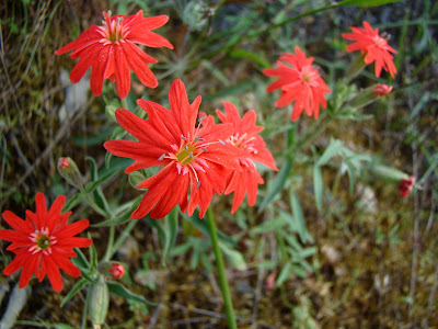
I'm pretty sure I've never closely observed these striking scarlet colored flowers up close. I suspect that I mistook them for Indian Paintbrush in the past, but a close look this week made it clear that they are something entirely different. These showy flowers are called Indian Pink (Silene californica), or Catchfly, or Campion. None of my internet sites seem clear on why they are called Pinks when they clearly are not. It may refer to the pink at the center of the flower, or that they are part of a family of flowers that include pink varieties. The "Catchfly" name refers to sticky parts of the flower that sometimes traps insects.
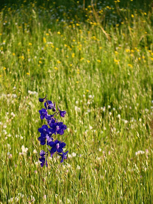
In a meadow near the summit of Marshes Flat Road, we found a beautiful purple flower that seems to be a Larkspur (Delphinium species). Besides being very obvious, it is also highly poisonous to cattle.
Another flower that did not seem at all familiar was the White Fairy Lantern (Calochortus albus), which is a member of the lily family. The flowers never really completely open up (gotta make those bugs earn their nectar?).


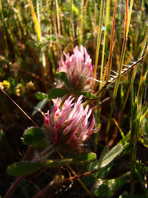
I've seen Clover (Trifolium sp) many times in springtime meadows, but I've never really gotten down on the ground to have a closer look.
I've also noticed this beautiful small pink flower in the past (below), but never identified it. I was surprised to find it is called Wild Carnation (Petrorhagia dubia). The genus name translates to rock fissure, referring to where some of the species grow. It is actually native to Europe.
Of course, flowers aren't the only things we see. The oak trees were bright green, and quite a few Acorn Woodpeckers were flitting about. They didn't pose very nicely for me, but I got one shot that allowed me to identify this shy one.
As always, being the non-expert botanist, I am open to corrections for any misidentifications! More spring updates as I find excuses to hit the road!

Monday, October 25, 2010

Liken' Lichens a Lot Lately...Fall Report from the Sierra Foothills

It was a beautiful sparkling clear day following yesterday's storm that dumped 3-4 inches of rain on many parts of Central and Northern California, so we decided to do our first fall reconnaissance in the Sierra Nevada foothills. We drove up Marshes Flat Road between LaGrange and Moccasin and found that fall really hasn't arrived yet at the lower elevations, just a bit of yellowing among the sycamores.
We did stop for a few moments to look over a rejuvenated brook, and I took a closer look at the rock surfaces, which consisted mostly of metamorphic greenstone and ultramafic serpentinite. My attention was drawn to the lichens on the rock surface, and I took some macro images. The lichens occupy a strange world we don't see all that often. They live on a different scale at the interface between rock and atmosphere. The acids they produce are one of the elements in the weathering and chemical breakdown of exposed bedrock.

Lichens are a complex symbiosis of algae and fungi. There are probably 500 different species in nearby Yosemite National Park, though only 100 have been so far cataloged. I have really only just begun to study these fascinating life forms closely.

Marshes Flat Road is a nice quiet avenue that crosses the high ridge east of Highway 49 between Coulterville and Chineses Camp. Paved, but mostly 1 1/2 lanes, it offers some nice views and excellent wildflower displays in the springtime.

It's an entirely different region, but I am also offering my favorite shot of a lichen, a display from a basalt boulder in the Mojave Desert Scenic Preserve in southern California. The colors are stunning to me. Lichens survive in a lot of tough environments!

Saturday, March 20, 2010

The Other California: The Day of the Fiddlenecks (a trip in the Mother Lode)

The Other California is my continuing exploration of the places in our state that don't tend to show up on the postcards, and are missed by most of the visitors. It's the first day of spring and we headed up into the Sierra Nevada foothills to seek out the Golden Poppy, which should be blooming explosively on the grassy slopes by now. We traveled east on Highway 132 out of Waterford towards the Gold-Rush-era town of La Grange. The poppies hadn't popped out in the lower foothill areas, but the slopes were alive with one of my favorite flowers, the Fiddleneck (Amsinckia). The shape of the flower is reminiscent of the head of a violin.

Amsinckia was utilized as a medicine and a food source by Native Americans, but the seeds and foliage are toxic to cattle. Today, for us, it was a beautiful splash of color along the slopes of the Tuolumne River, which were following out of the Central Valley.

Upstream, the first bedrock outcrops we encountered were low cliffs of rhyolitic ash of the Valley Springs formation. This gentle, quiet landscape was the scene of great violence between 22 and 28 million years ago, as huge calderas to the east exploded out vast amounts of pulverized rock and sent clouds rolling down the slopes of what would one day be the western Sierra Nevada. The rock is solid enough to form cliffs, but is easily shaped, so it was ideal for use as a building stone in the towns of the Mother Lode.

We passed through the quiet village of La Grange, looking at the 1875-vintage schoolhouse and cemetery, and a short distance east we encountered some of the evidence of gold mining (below). The sediments covering the surface were washed away to get at gold particles trapped in the small fissures and cracks in the bedrock below. Sometimes hoses were used. Downstream, where the sediments were deeper, giant dredges were used (these methods will be discussed in later posts). One of the dredges used in the area sits abandoned in a meadow just south of La Grange.

A bit east of the hydraulic pits, the old metamorphic rock of the Foothills Terrane start peeking through the soil cover. These so-called "tombstone rocks" are slate and phyllite that originated as mud and silt on the ocean floor which were accreted to the western edge of the North American continent in Mesozoic time.

Some of the rocks include metavolcanic rocks and an occasional metaconglomerate (picture below, very small penny for scale). These rocks are far more resistant to erosion, and form long high north-trending ridges in the western Mother Lode. We found a delightful new pathway over the metavolcanic ridges from Don Pedro Reservoir to the village of Moccasin along Marshes Flat Road. On this spring day, greenery was everywhere, and most of the gullies had streams flowing.

Did we find poppies? They aren't widespread just yet, but a few beautiful patches showed up along Marshes Flat road. There will be a great many more in the coming weeks. If you are in the area, make time to check it out!

For an excellent road guide to some of the areas covered in this post, and for a discussion of remediation efforts along the Tuolumne River region, check out this guide from the National Association of Geoscience Teachers and Columbia College.