Re-posting from 1/10/20. Our organizational meeting is on Thursday, January 30, at 5:30 PM in Science Community Center Room 326 (the Geology Lab). If you can't make the meeting but wish to join the class, contact me.
Some lands are harsh and lie at the limits of human survival...visiting or inhabiting these lands without preparation would be deadly, and if you are dying of thirst or exposure, you're hardly going to care about the rugged beauty around you.
People have lived in this place in small numbers for at least 10,000 years. Four distinct cultures are known, including the Timbisha Shoshone who still live in the region. They were able to live and thrive within the limits imposed by this extreme desert environment. The first Europeans to arrive during the Gold Rush era were not prepared for the conditions, and it was they who conferred the present-day name of the park: Death Valley.
We are privileged to live in a time and place where technology allows us to visit these lands with our basic needs fulfilled, allowing us to appreciate the landscape and story behind the scenery. This is not to minimize the risks involved when the technology (or basic intelligence) fails us. Death Valley continues to be a dangerous place for the unprepared and people get into serious predicaments every year.
But what a place it is! Death Valley National Park is the largest park in the lower 48 states, and it preserves upwards of 2 billion years of earth history. The story in the rocks is more complete than any other park in the country, including even the Grand Canyon. The Paleozoic sediments alone are 20,000 feet thick, and the late Proterozoic rocks add 15,000 feet more. There are metamorphic rocks that are among the oldest in the American west, and volcanic rocks that are among the youngest (perhaps only a few hundred years).
The landscape is spectacular as well. The floor of Death Valley is the lowest and driest place in North America, and the hottest place in the world. Elevations range from -286 feet to more than 11,000 feet. There are times when one can stand in the broiling sun at Badwater and look at snowbanks on Telescope Peak. There are faults and badlands, alluvial fans and barren salt flats. There are hundreds of plant and animal species, including four species of fish (seriously).
Does this sound intriguing, a kind of place that you might like to visit? You could be there in a few weeks, and learn the details of the geologic story of this unique and precious place. I'll be teaching a 2-unit course on the geology Death Valley through Modesto Junior College on Feb. 13-17, 2020. We'll be camping out and spending our days hiking and exploring this fascinating place. If this all sounds interesting, join us! If you live in the Modesto area, we'll have an informational meeting on Thursday, January 30 at 5:30 PM in Science Community Center Room 326. If you can't make the meeting, all the trip information is available at the class website at: http://hayesg.faculty.mjc.edu/Death_Valley_Field_Studies.html. Information on registration for classes at Modesto Junior College can be found at https://www.mjc.edu/.
Come and join us!
Showing posts with label earth science education. Show all posts
Monday, January 27, 2020
Friday, January 10, 2020
To the Unprepared, it is the Place of Death; For Scholars of Earth History, it's a Wonderland. Join us, February 13-17, in Death Valley!
Some lands are harsh and lie at the limits of human survival...visiting or inhabiting these lands without preparation would be deadly, and if you are dying of thirst or exposure, you're hardly going to care about the rugged beauty around you.
People have lived in this place in small numbers for at least 10,000 years. Four distinct cultures are known, including the Timbisha Shoshone who still live in the region. They were able to live and thrive within the limits imposed by this extreme desert environment. The first Europeans to arrive during the Gold Rush era were not prepared for the conditions, and it was they who conferred the present-day name of the park: Death Valley.
We are privileged to live in a time and place where technology allows us to visit these lands with our basic needs fulfilled, allowing us to appreciate the landscape and story behind the scenery. This is not to minimize the risks involved when the technology (or basic intelligence) fails us. Death Valley continues to be a dangerous place for the unprepared and people get into serious predicaments every year.
But what a place it is! Death Valley National Park is the largest park in the lower 48 states, and it preserves upwards of 2 billion years of earth history. The story in the rocks is more complete than any other park in the country, including even the Grand Canyon. The Paleozoic sediments alone are 20,000 feet thick, and the late Proterozoic rocks add 15,000 feet more. There are metamorphic rocks that are among the oldest in the American west, and volcanic rocks that are among the youngest (perhaps only a few hundred years).
The landscape is spectacular as well. The floor of Death Valley is the lowest and driest place in North America, and the hottest place in the world. Elevations range from -286 feet to more than 11,000 feet. There are times when one can stand in the broiling sun at Badwater and look at snowbanks on Telescope Peak. There are faults and badlands, alluvial fans and barren salt flats. There are hundreds of plant and animal species, including four species of fish (seriously).
Does this sound intriguing, a kind of place that you might like to visit? You could be there in a few weeks, and learn the details of the geologic story of this unique and precious place. I'll be teaching a 2-unit course on the geology Death Valley through Modesto Junior College on Feb. 13-17, 2020. We'll be camping out and spending our days hiking and exploring this fascinating place. If this all sounds interesting, join us! If you live in the Modesto area, we'll have an informational meeting on Thursday, January 30 at 5:30 PM in Science Community Center Room 326. If you can't make the meeting, all the trip information is available at the class website at: http://hayesg.faculty.mjc.edu/Death_Valley_Field_Studies.html. Information on registration for classes at Modesto Junior College can be found at https://www.mjc.edu/.
Come and join us!
Tuesday, October 15, 2019
Its Really Been That Long? 30th Anniversary of the Loma Prieta Earthquake on Thursday
It's Earth Science Week, and "Geoscience is for Everyone" is the theme for this year. Geoscience IS for everyone, because geology dominates the lives of everyone. No one can escape it, for better or worse. Better, when we find inspiration in the awesome forces that have made our planet, and worse for the geologic hazards that exist everywhere on the planet in one form or another. Here in California, one of the premier hazards are the earthquakes that occur here with disturbing irregularity (it would be so much nicer if they followed schedules so we could prepare). I'm writing about the anniversary of the Loma Prieta earthquake a few days early, but we had two moderate earthquakes in less than 24 hours in Northern California (magnitude 4.5 and 4.7), so seismic things are on my mind.
We can only share our stories to keep that knowledge at the forefront that will allow us to survive and recover from the major earthquakes to come. Here's my story from 1989, when my teaching career was just beginning.
On October 17th, 1989 at 5:04 PM, my physical geology laboratory had just finished and almost everyone had gone home to watch the World Series. A couple of students were helping me (it was Maureen and Sonny; funny how I remember the names of the first students I had better than the ones I had last semester). We were 100 kilometers from the epicenter, so when the seismic waves started to shake our building, the movement was a strong rolling motion instead of sharp vibrations. We looked at swaying TV monitors, and commented that it was an earthquake. It was a most scholarly discussion, actually. We realized the shaking was not stopping, and we thought we could sense the direction of the quake as well. We started to guess where it might be happening, but when the shaking reached the 40 second mark (the energy was spreading out, it lasted only 10 seconds or so near the epicenter), we realized it was a major event, and that fatalities were probably occurring (and unfortunately we were right). The deodar trees out the window were whipping back and forth as if they were in a high wind. The strangest part for me was the unconscious decision I was making as the shaking progressed. Despite having a quiet scholarly discussion, my body was moving from the front of the podium to the back, where there was a nice solid space to hide under. I would have dived under if the quake had lasted any longer.
In hindsight, I should have been a bit more aggressive about taking shelter under the desk. An analysis of our building a year or two later revealed an architectural weakness that suggested the building could collapse if the seismic waves hit it from a particular direction. A seismic retrofit a decade later included some massive shear walls in the lab I taught in.
![]() |
Two good-sized earthquakes as recorded at Modesto Junior College |
![]() |
No, this isn't what happens (credit: A. June) |
![]() |
Well, this can happen, but most people survive, even in the worst of quakes (credit: A. June) |
Meanwhile, at the city library, my children were making me proud. At the time of the quake, there were huge sailing ship models on display, in some cases right on top of the book stacks. The stacks were not reinforced or braced, so there was a real potential for injuries if the quake was strong enough to knock those stacks over. I was told that most people were just standing there watching the bookstacks swaying, but my kids, my well-trained and intelligent kids were the only people in the room to take shelter under the sturdy study tables. Luckily, as I said before, we were on the fringes of the effects of the earthquake and no one was hurt.
The Loma Prieta earthquake, a magnitude 6.9 event at a depth of 11 miles, was a tragedy: 63 people died, and 3,700 were injured. If the World Series game between the A's and the Giants hadn't been about to start, the death toll would have been much higher. Traffic was stunningly light that afternoon. Despite this, the Bay Area was in chaos for days, and months passed before life got back to normal. We were on the fringes, so instead of pain and suffering, we had a profound learning experience that was remembered by my students for the next decade and a half. But it has been 30 years now, and many of my students weren't born when the quake happened. Few of them have felt a quake at all. The large quakes like Loma Prieta and Northridge are ancient history, and there is less of that innate knowledge of what they should do when one hits. Few admit to having any kind of emergency kits at home, and they have no plan for what to do when the next big one hits.
Fault studies across California make it clear that more big tremors are coming, almost surely within the next decade or two. We educators must keep these past events alive in the minds of our students so they will be ready for these events when they come.
This is an abridged version of a blogpost from 2009.
Tuesday, June 18, 2019
Our Newest Department Acquisition Has Arrived! Paleontologist Barbie!
21st Century Paleontologist Barbie |
There's a story from the history annals of the geology department where I teach. In 1996, Mattel came out with a Paleontologist Barbie. Someone brought one by the lab one day, and a fascinating discussion followed. The women were just a bit brutal and offered a long list of "improvements" that would add to the authenticity of the doll. These included bruises, scrapes, and bandages for the legs, and suggestions of either deeply tangled and ratted hair from the desert wind, or hair cut very short. There should be the geologist's tan, the one caused by knee socks and short pants. The blouse most certainly did not garner kind reviews. I sort of wish that I had picked one up for the lab back then. Boxed versions of the doll are bringing in offers of $80-90 these days from resellers.
![]() |
Paleontologist Barbie, 1996 |
So we fast-forward to the present day...much about the world is changed, but Barbie lives on. I had not been following the line of Barbie dolls for at least two decades, and I was surprised to find that there is an entire line of careers for Barbie dolls and that ethnicities beyond blonde white woman are part of the line-up. It's a welcome change, but because of a Facebook discussion, I was looking for images of the ancient Barbie Doll online...and found that Paleontologist Barbie has been resurrected!
I wasn't going to make a mistake again and ordered one right away ($12.95 plus tax). It arrived this week, and I welcome your observations and suggestions about how future Paleontologist Barbie in 2050 can be improved.
My first impression about 2019 Barbie is that she is rolling her eyes in exasperation (see the first photo). This no doubt is because some supervisor is mansplaining something to her on a subject in which she is an expert. The utility vest over a blue shirt is a good change, much more efficient than a dinosaur blouse. I'm not so sure about the hardhat. I guess some fossil excavations take place in quarries, but most of my personal experiences have been in desert or prairie in the hot sun where a broad-rimmed hat makes a lot more sense. The original 1996 Barbie had a hat and a canteen.
The fossil sample was a revelation. I wasn't sure at first what to make of the fossil assemblage. As best I could tell, it's an ammonite fossil (a marine creature), along with a fern (terrestrial), and the tracks of...something. It makes no sense...except for this fact: recent news of the discovery of a dinosaur extinction/tsunami assemblage in North Dakota that included ammonite fragments along with terrestrial vegetation fossils and fragments of terrestrial animals! This specimen is amazingly prescient!
The boots seem serviceable enough, but there ought to be some thick socks. Blisters are a real problem out there in the field. I couldn't find any images of the footwear of 1996 Paleontologist Barbie.
I'm old enough and far-enough removed from the days of having a young daughter in the house that I still think of Barbie as a helpless princess, so I'm glad to find that the toy line has displayed some sensitivity to the career opportunities available for young girls of all ethnicities to dream about. I am actually going to put the doll in the lab along with Gumby and Pokey, and a host of toy dinosaurs and other prehistoric creatures. I do in fact have children visiting in the lab on occasion, and I would like for them to be able to see themselves as geologists and paleontologists.
Monday, January 28, 2019
Exploring our Precious (and Abused) Places: Death Valley - February 14-18, 2019
Now that the much-lamented government shutdown is over (for the time being), some of our attention can turn to our much abused national parks and monuments. It was a crime that they were left exposed to abuse, and it is a shame that some people saw the closure of the government as a ticket to vandalize our precious places.
And they are precious beyond words. Death Valley National Park is the largest park in the lower 48 states, and it preserves upwards of 2 billion years of earth history. The story in the rocks is more complete than any other park in the country, including even the Grand Canyon. The Paleozoic sediments alone are 20,000 feet thick, and the late Proterozoic rocks add 15,000 feet more. There are metamorphic rocks that are among the oldest in the American west, and volcanic rocks that are among the youngest (perhaps only a few hundred years).
The landscape is spectacular as well. The floor of Death Valley is the lowest and driest place in North America, and the hottest place in the world. Elevations range from -286 feet to more than 11,000 feet. There are times when one can stand in the broiling sun at Badwater and look at snowbanks on Telescope Peak. There are faults and badlands, alluvial fans and barren salt flats. There are hundreds of plant and animal species, including four species of fish (seriously).
Does this sound intriguing, a kind of place that you might like to visit? You could be there in a few weeks, and learn the details of the geologic story of this unique and precious place. I'll be teaching a 2-unit course on the geology Death Valley through Modesto Junior College on Feb. 14-18. We'll be camping out and spending our days hiking and exploring this fascinating place. If this all sounds interesting, join us! If you live in the Modesto area, we'll have an informational meeting on Thursday, January 31 at 5:30 PM in Science Community Center Room 326. If you can't make the meeting, all the trip information is available at the class website at: http://hayesg.faculty.mjc.edu/Death_Valley_Field_Studies.html. Information on registration for classes at Modesto Junior College can be found at https://www.mjc.edu/.
Come and join us!
Thursday, October 18, 2018
Earth as Inspiration: It's Coyote and Roadrunner! (Except that it's not a Coyote, and the bird wasn't a Roadrunner)
It's Earth Science Week, and the theme this year is Earth as Inspiration. It may seem strange that I would open this blog with a picture of cute furry creature when we should be discussing the Earth, but bear with me. I find the inspiration wherever I can!
I live in the midst of California's Great Valley, but to many people it isn't all that "great". Modesto regularly ends up as 48th or 49th on the lists of the "best places to live" in the U.S. We are in a perpetual depression, with unemployment levels that are around twice the national average, and the median household income lags badly behind the national average. Pretty dismal, many things considered, but not all. There are some real treasures to be found among the dusty fields. And those treasures are related to the earth sciences.
The Great Valley originated as a forearc basin between the vast subduction zone that once existed offshore of California during the age of the dinosaurs (the Mesozoic Era), and the chain of volcanoes that erupted miles above the magma chambers that would one day cool to become the granitic rocks of the Sierra Nevada. For most of its history the valley was a shallow sea, home to huge swimming reptiles during the age of dinosaurs, and gigantic sharks and a variety of whales, dolphins and seals during the Cenozoic Era that followed. It was only a few million years ago that the valley floor rose above sea level to become the grassy savanna that it was prior to the arrival of European settlers and farmers. The valley was populated by a bewildering array of strange mammals like mammoths, mastodons, giant ground sloths, gigantic Short-faced Bears, Saber-tooth Cats, Dire Wolves, horses, and camels. Many of these animals went extinct around 12,000 years ago, but even 300 years ago there were herds of Tule Elk, deer, Pronghorn, Grizzly Bears, Wolves, and Mountain Lions. And there were birds. Millions and millions of migratory birds who made the valley wetlands their winter home.
Eventually 95% of the valley was co-opted by agricultural development, and most of the natural primeval landscape was lost. But fragments remain here and there. There are still prairies around the margins of the valley that were simply grazed and not plowed. There were river floodplains that flooded too often to be developed as farmlands. And some animals adapted to the new state of affairs and have thrived in human landscapes.
That is where my inspiration came from this evening. I was out taking my normal walk for exercise and bird-searching when I came across a wild chicken. Well, not really a wild chicken, but apparently an escapee from the campus chicken coop (we have a big agriculture unit at our school). And it looked nervous. A moment later I saw why: it was being stalked by a Gray Fox (Urocyon cinereoargenteus). I've seen Red Foxes on the campus before; they're an introduced species. But this was the first time I got a clear view of the native Gray Fox (I saw one in the dark a few weeks ago).
The fox was very intent on its quarry and didn't notice me at first. I was able to get a few shots of it before it retreated into the bushes behind the farm machinery. The chicken also headed into the bushes, relieved that the chase was at least temporarily put on hold. But the whole episode reminded me of a great thing happening on our campus.
We are building a small version of our valley's native ecosystem on the vacant space north of our Great Valley Museum. It will be called the Great Valley Outdoor Nature Lab, and it will include several acres of native vegetation, a vernal pool, and some of the rocks characteristic of the margins of our valley. It might not be large enough to serve as a home base for the fox, but it will attract the native birds, and maybe some of the native amphibians and reptiles. The work is well underway, and by January we should have a mostly operational outdoor lab. Local school children, many of whom almost never have a chance to leave the city limits, will have an opportunity to see the natural history museum exhibits, and then step outside to see the native trees and vegetation, and perhaps even some native birds, ground squirrels or lizards, and if they are really lucky, a Gray Fox.
Wednesday, October 17, 2018
Earth as Inspiration: Memories on the 29th Anniversary of the Loma Prieta Earthquake
It's Earth Science Week, and "Earth as Inspiration" is the theme for this year. Inspiration can take many forms. Sometimes it is awe-inspiring beauty, something our planet has in great bounty. But the earth can kill, and inspiration can be related to preparation for disasters.
On October 17th at 5:04 PM, my physical geology laboratory had just finished and almost everyone had gone home to watch the World Series. A couple of students were helping me (it was Maureen and Sonny; funny how I remember the names of the first students I had better than the ones I had last semester). We were 100 kilometers from the epicenter, so when the seismic waves started to shake our building, the movement was a strong rolling motion instead of sharp vibrations. We looked at swaying TV monitors, and commented that it was an earthquake. It was a most scholarly discussion, actually. We realized the shaking was not stopping, and we thought we could sense the direction of the quake as well. We started to guess where it might be happening, but when the shaking reached the 40 second mark (the energy was spreading out, it lasted only 10 seconds or so near the epicenter), we realized it was a major event, and that fatalities were probably occurring (and unfortunately we were right). The deodar trees out the window were whipping back and forth as if they were in a high wind. The strangest part for me was the unconscious decision I was making as the shaking progressed. Despite having a quiet scholarly discussion, my body was moving from the front of the podium to the back, where there was a nice solid space to hide under. I would have dived under if the quake had lasted any longer.
In hindsight, I should have been a bit more aggressive about taking shelter under the desk. An analysis of our building a year or two later revealed an architectural weakness that suggested the building could collapse if the seismic waves hit it from a particular direction. A seismic retrofit a decade later included some massive shear walls in the lab I taught in.
![]() |
No, this isn't what happens (credit: A. June) |
![]() |
Well, this can happen, but most people survive, even in the worst of quakes (credit: A. June) |
Meanwhile, at the city library, my children were making me proud. At the time of the quake, there were huge sailing ship models on display, in some cases right on top of the book stacks. The stacks were not reinforced or braced, so there was a real potential for injuries if the quake was strong enough to knock those stacks over. I was told that most people were just standing there watching the bookstacks swaying, but my kids, my well-trained and intelligent kids were the only people in the room to take shelter under the sturdy study tables. Luckily, as I said before, we were on the fringes of the effects of the earthquake and no one was hurt.
The Loma Prieta earthquake, a magnitude 6.9 event at a depth of 11 miles, was a tragedy: 63 people died, and 3,700 were injured. If the World Series game between the A's and the Giants hadn't been about to start, the death toll would have been much higher. Traffic was stunningly light that afternoon. Despite this, the Bay Area was in chaos for days and months passed before life got back to normal. We were on the fringes, so instead of pain and suffering, we had a profound learning experience that was remembered by my students for the next decade and a half. But it has been 29 years now, and many of my students weren't born when the quake happened. Few of them have felt a quake at all. The large quakes like Loma Prieta and Northridge are ancient history, and there is less of that innate knowledge of what they should do when one hits. Few admit to having any kind of emergency kits at home, and they have no plan for what to do when the next big one hits.
Fault studies across California make it clear that more big tremors are coming, almost surely within the next decade or two. We educators must keep these past events alive in the minds of our students so they will be ready for these events when they come.
This is an abridged version of a blogpost from 2009.
Tuesday, October 16, 2018
Earth as Inspiration: Mt. Shasta for Earth Science Week, October 14-20
Mt. Shasta and Shastina from the north |
I usually don't need an inspiration to write about Mt. Shasta, but I realized (two days in) that October 14-20 is national Earth Science week, and the theme of the celebration this year is "Earth as Inspiration". In case you have not yet realized this yet, but I am in fact inspired by the Earth. It started early on in my life with family vacations to some stunning places in California and the American Southwest, continued with scouting experiences nearly every weekend in my teens that included extensive work with topographic maps, and right into my college major and subsequent career as a geology professor. And then I found the form of story-telling called blogging in 2008.
Panther Meadows at the 8,000 foot level on Mt. Shasta |
Mt. Shasta is an earthly inspiration. We visited two weeks ago as part of our field course on California's volcanoes. The stops included a drive to the end of the highway at Panther Meadows at 8,000 feet on the side of the 14,179 foot high volcano, and another stop on the north flank where we could see the glaciers and one other astounding feature of the volcano (mentioned below). Shasta is the second tallest volcano (behind Mt. Rainier) but is the most voluminous composite cone (stratovolcano) in the range (I'm parsing words here; there is a larger volcano, but it is of a different kind and will be discussed in a future blog). As a classic composite cone, it is composed of the remains of at least four previous incarnations, capped by the current active vent, Hotlum Cone. The oldest lava and ash dates back to around 600,000 years ago, but the youngest is a mere couple of hundred years. It likely erupted in 1786.
As the highest mountain in Northern California, it supports seven glaciers. Whitney Glacier, with a length of two miles, is the longest in the state (below). The glaciers are responsible for one of Shasta's unique hazards: jokulhlaups! These are floods caused when meltwater is sealed underneath the glacial ice which then breaks out in a catastrophic manner. Although caused by eruptions under the glacial ice in places like Iceland, those that occur on Shasta can happen almost any time. They are generally more of a nuisance, messing up roads and bridges, rather than a killer.
The biggest dangers of a volcano like Shasta are volcanic mudflows (lahars), and hot ash flow eruptions. Lava flows, unless they interact with the ice, are of a lesser concern. Andesite lava has a pasty consistency and is not likely to flow overly far from vents on the mountain. Lahars are of the greater concern, as they are capable of producing massive casualties and structural damage. The towns of Mt. Shasta, Weed, and McCloud are constructed on old lahar deposits. Major events could cause the closure of Interstate 5. Hot Pompeii-style ash eruptions are somewhat less likely, based on the previous history of the volcano.
Whitney Glacier, the largest in California |
The St. Helens eruption was initiated when an earthquake caused the entire north flank of the volcano to collapse in a gigantic debris avalanche that traveled for twelve miles down the Toutle River valley. Humans had never witnessed a landslide so large. It uncapped the volcano, leading to the very explosive ash eruption that followed.
To the geologists studying the region around Shasta, it was a revelation. The avalanche at St. Helens formed hundreds of hummocks similar to those found at Shasta. It quickly became clear that the deposit on the north flank of Shasta was the remains of a gigantic debris avalanche. The St. Helens avalanche involved less than a cubic mile of material (0.67 cubic miles), but the now-apparent debris avalanche at Shasta was ten times larger (about 6.5 cubic miles), and it traveled twice as far. It seems to have happened between 360,000 and 300,000 years ago. It's stunning just to image seeing something like this happen.
What aspects of the Earth do you find inspiring?
Monday, December 11, 2017
Every Victory is Fragile, Every Loss is Catastrophic: Bear's Ears National Monument and the Valley of the Gods
Bear's Ears National Monument is a magical place. It is a place of mystery and vast vistas, a place of sacredness to many people. It is one of our country's most precious treasures. When President Obama accepted years of negotiation and work by "stakeholders" in the region and established the monument in 2016, I rejoiced. But I knew that the victory would be fleeting because of the election of rapacious vile people who only understand dollar signs. Bear's Ears National Monument is under an existential threat by Secretary of the Interior Zinke, Trump, and certain local officials. Trump recently exceeded his authority and tried to shrink the monument by 85%, and the matter is now in court. New documents suggest that Zinke used recommendations by Canadian uranium mining companies to redraw the boundaries, which just happened to remove monument protection from potential uranium ore-bearing formations. It is a "land grab" of breath-taking proportions, and not in a good way.
![]() |
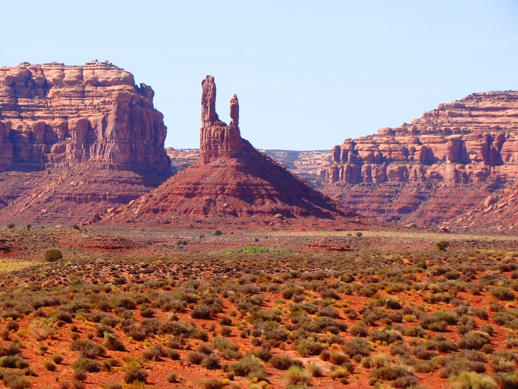
Monument Valley from the edge of Cedar Mesa at Muley Point |
Pareidolia is a very human tendency to perceive faces and significant forms in unlikely places, like on oddly shaped potatoes and burnt tortillas. It is what allows us to see the "Man in the Moon". It's hardwired into our brains, and I wouldn't be surprised if it arose out of a need to recognize the eyes and faces of creatures that in a past era would have eaten us.
We journeyed to the region in 2013, and we were headed into one of the more isolated corners of the Colorado Plateau. After traveling through Monument Valley, we turned north into Mexican Hat, Utah, and headed up a gravel road into Valley of the Gods. This was new for me; in a quarter of a century, I somehow had never found the time to explore the 17 mile loop through a series of amphitheaters along the eastern margin of Cedar Mesa. It was a magical place, and in 2016 it was included within the boundaries of Bear's Ears National Monument. In 2017 it was removed from protection.
![]() |
The Sitting Hen at Valley of the Gods, from the back |
I find myself speculating about the connections between magic and science when I am in a place like Valley of the Gods. Science has given us a "creation myth" about how these rock pedestals formed. The cliff-forming unit is the Cedar Mesa Sandstone, which formed in coastal dunes and beaches in Permian time perhaps 270 million years ago. The underlying ledge-forming rock is the Halgaito Shale, which formed in coastal deltas and shallow marine conditions somewhat earlier in the Permian Period. The spires formed from cliff retreat as the softer Halgaito rock undercut the sandstone cliffs (I described the process in an earlier post). Tricks and variations in the erosional process formed the hollows and shadows that give the pedestals their eyes and faces.
![]() |
The Sitting Hen, or as I like to call it, the Rubber Ducky at Valley of the Gods. |
![]() |
The Battleship, right out of Monopoly! |
Does science deny the possibility of aliens carving these exquisite sculptures, or that gods turned miscreant humans into stone? Actually, science doesn't. It does in fact state that these other explanations could be true but that the probability is extremely low, based on the absolute paucity of supporting evidence. The scientific explanation is supported by extensive and overwhelming evidence. Scientists would acknowledge that the presently accepted explanation could be supplanted were new evidence were to emerge. Indeed they expect such changes in the fullness of time.
Compare this attitude to that of someone who has decided on an explanation, truly believes it, and chooses to ignore any contrary evidence. There is no growth, no increase in knowledge in such an person. Belief doesn't make it real, but evidence makes an explanation more likely.
Some might say that science removes the excitement and mystery of a good creation story. I would respectfully disagree. I would say that an understanding of geologic processes leads to more mystery and wonder. Consider the rocks; once one realizes that these rocks were part of a coastal complex, the question arises: where was the ocean and why was it in this place? Today the oceans are a thousand miles away. These rocks were eroded from a mountain range somewhere. Could we find where that mountain range was? Why did those mountains rise? What forces were acting on the crust to cause them to develop? What kinds of creatures lived on these floodplains and deltas? Where did they come from? What happened to them? As it turns out, the world was only a few million years from the worst extinction event ever to take place on planet Earth. Some 95% of all species on the planet vanished 252 million years ago. All these questions invite further study and further growth. Each effort to answer these questions adds to the body of human knowledge. It is a creation story that grows and changes with the addition of new data.
On the other hand, it's fun to play games with these fascinating forms of nature. What do you think they are?
I know this: they are beautiful to gaze upon, even if beauty is a subjective judgement. Did the humans who first saw these desert monuments see them as beautiful? Or were they simply part of a rugged harsh landscape that may or may not be hiding a resource that could extend human life in this tough land?
![]() |
I definitely see a huge mechanical hand rising out of the ground. |
We passed the base of Lady in a Bathtub (picture below) and drove back down to Mexican Hat for one last stop in civilization. We were headed onto Cedar Mesa, another special place that was protected under the monument status of Bear's Ears, and which illegally lost protection under the new directives from the administration.
![]() |
The Lady in the Bathtub. |
The loop road through Valley of the Gods is accessed from US 163 out of Mexican Hat, Utah, while the west entrance is on US 261 near the base of the Moki Dugway. There are no facilities along the loop, which is managed and maintained by the Bureau of Land Management. There is a small campsite at nearby Goosenecks of the San Juan State Park, but no water is available. If you go, bring a camera or sketchpad. Even if you never go, fight for the protection of these lands by contacting your representatives in Congress, and support the organizations who are suing the administration over its illegal actions.
Sunday, September 24, 2017
Say Hello to California's New State Dinosaur: Augustynolophus morrisi
This one really got past me. I have to admit that the whole business of establishing a California State Dinosaur flew way under my radar. But it happened, Jerry Brown signed the bill, and Augustynolophus morrisi is our newest state emblem (along with our state fabric, denim). Although much of the attention on this Saurolophus species is directed towards two specimens found in the Panoche Hills of Fresno County in 1939-40, few people are aware of the story of California's first dinosaur discovery. It happened in 1936, and it was found in our own county of Stanislaus. I've written about this story before, so what follows is an abridged version.
OMG! Somebody caught Jar Jar Binks! Okay, not really. But what the heck is this thing?
Say hello (sort of, since my skull is a closely related species) to Augustynolophus morrisi, our newly designated official state dinosaur!
We have half a million people in our county, and I'm willing to bet that 99% of them don't know what it is or why it's important to them. Only one person got to be the first to find a dinosaur bone in California, and that was 17-year-old Al Bennison in 1936. He was exploring Del Puerto Canyon in the Coast Ranges along the western part of Stanislaus County looking for shell fossils when he found bones scattered on a slope. He showed them to his science teacher who reported them to the paleontologists at U.C. Berkeley. A year later Bennison discovered the most complete mosasaur skull ever found in California (see below). The mosasaur species even bears his name. It may not be much of a surprise that he went on to become a paleontologist. I had the privilege of meeting him in 1996, when he took us to his original discovery site, shown above.
The Saurolophus was one of the last dinosaurs that ever lived on our planet, one the last groups in existence when the gigantic asteroid hit the planet (or when the volcanoes blew, or whatever else did them in). They lived in the latest part of the Cretaceous Period, which is well represented by sedimentary rocks in our region. The rocks are marine in origin, which tend not to be good places to search for dinosaurs, but sometimes a carcass would float out to sea.
The creatures were gigantic, on the order of thirty to forty feet long, weighing several tons. They were plant-eaters, with teeth well-adapted to grinding twigs and leaves. Whether they swam or not has been a topic of discussion and debate. Some argue that they had few other defenses from predators, so that swimming was necessary to escape from being eaten. Others suggest that they lived in herds that provided protection.
Our skull collection is now a powerful tool for teaching the students in our region about the heritage of the land that they live on. In the picture above, one can compare the Cretaceous plant-eater with the skull of a Short-faced Bear, which lived in our area during the Ice Ages during the last two million years. It may have been the single largest mammalian land predator that ever lived, with a standing height of 11 feet. It would have made a grizzly bear look small in comparison.
The picture above shows our other recent arrival, the Mosasaur, similar to the one found by Al Bennison during the 1950s in the Coast Ranges just south of our county. It was not a dinosaur but was instead a seagoing reptile from the Cretaceous Period that may have snacked on sharks. It was around thirty feet long. It is probably the most formidable predator ever to inhabit our region.
To give a sense of scale, we have the Mosasaur nosing an Ice Age Sabertooth Cat skull (the cats weighed 700 pounds), and one of those wimps of the early Cretaceous, Velociraptor (which came out of Mongolia, not the Americas).
Dinosaurs certainly capture the imagination of our children (and not a few of our adults), and it is a good thing for our students to know that our county played an important part in the paleontological discoveries in our state. When students realize that one of their own (however long ago) made an important find, they also can visualize themselves as a paleontologist or geologist making important contributions to science.
Augustynolophus has its own Twitter handle, so check out developments at https://twitter.com/augustynolophus/. The Wikipedia page has been updated as well. For the best source of information on dinosaurs and other Mesozoic reptiles of California, check out this book by Richard Hilton of Sierra College.
OMG! Somebody caught Jar Jar Binks! Okay, not really. But what the heck is this thing?
![]() |
This is a skull replica of Saurolophus angustirostris, a closely related species from Mongolia |
We have half a million people in our county, and I'm willing to bet that 99% of them don't know what it is or why it's important to them. Only one person got to be the first to find a dinosaur bone in California, and that was 17-year-old Al Bennison in 1936. He was exploring Del Puerto Canyon in the Coast Ranges along the western part of Stanislaus County looking for shell fossils when he found bones scattered on a slope. He showed them to his science teacher who reported them to the paleontologists at U.C. Berkeley. A year later Bennison discovered the most complete mosasaur skull ever found in California (see below). The mosasaur species even bears his name. It may not be much of a surprise that he went on to become a paleontologist. I had the privilege of meeting him in 1996, when he took us to his original discovery site, shown above.
The Saurolophus was one of the last dinosaurs that ever lived on our planet, one the last groups in existence when the gigantic asteroid hit the planet (or when the volcanoes blew, or whatever else did them in). They lived in the latest part of the Cretaceous Period, which is well represented by sedimentary rocks in our region. The rocks are marine in origin, which tend not to be good places to search for dinosaurs, but sometimes a carcass would float out to sea.
![]() |
Source: http://en.wikipedia.org/wiki/Saurolophus |
The creatures were gigantic, on the order of thirty to forty feet long, weighing several tons. They were plant-eaters, with teeth well-adapted to grinding twigs and leaves. Whether they swam or not has been a topic of discussion and debate. Some argue that they had few other defenses from predators, so that swimming was necessary to escape from being eaten. Others suggest that they lived in herds that provided protection.
Our skull collection is now a powerful tool for teaching the students in our region about the heritage of the land that they live on. In the picture above, one can compare the Cretaceous plant-eater with the skull of a Short-faced Bear, which lived in our area during the Ice Ages during the last two million years. It may have been the single largest mammalian land predator that ever lived, with a standing height of 11 feet. It would have made a grizzly bear look small in comparison.
The picture above shows our other recent arrival, the Mosasaur, similar to the one found by Al Bennison during the 1950s in the Coast Ranges just south of our county. It was not a dinosaur but was instead a seagoing reptile from the Cretaceous Period that may have snacked on sharks. It was around thirty feet long. It is probably the most formidable predator ever to inhabit our region.
To give a sense of scale, we have the Mosasaur nosing an Ice Age Sabertooth Cat skull (the cats weighed 700 pounds), and one of those wimps of the early Cretaceous, Velociraptor (which came out of Mongolia, not the Americas).
Dinosaurs certainly capture the imagination of our children (and not a few of our adults), and it is a good thing for our students to know that our county played an important part in the paleontological discoveries in our state. When students realize that one of their own (however long ago) made an important find, they also can visualize themselves as a paleontologist or geologist making important contributions to science.
![]() |
Source: http://upload.wikimedia.org/wikipedia/commons/4/4b/Saurolophus_scalation.png |
Augustynolophus has its own Twitter handle, so check out developments at https://twitter.com/augustynolophus/. The Wikipedia page has been updated as well. For the best source of information on dinosaurs and other Mesozoic reptiles of California, check out this book by Richard Hilton of Sierra College.
Subscribe to:
Posts (Atom)