Tuesday, March 15, 2016

A Far Too Rare Scene in These Parts in Recent Years: Flooding on Dry Creek

The latest storm to pass through Central California dropped 1.28 inches of rain in my backyard gauge, giving us 4.26 inches for the month of March, and about a third of a normal year's precipitation in the space of just ten days or so. By the time this last storm arrived, the watershed was saturated, and so Dry Creek...was not dry. It reached a peak flow of about 3,000 cubic feet per second yesterday.
 Unlike the Tuolumne River, there are no reservoirs like Don Pedro Dam to catch the runoff from the storms, so Dry Creek rises and falls quickly with the storms. The runoff shows two peaks, as there were a pair of storms over the weekend and Monday. The blue bars on the top show the amounts and timing of precipitation in the watershed, and the dotted line records the runoff. Notice the lag between the timing of the storms. This is the delay between the water falling from the sky, and the peak flow miles downstream. By analyzing the pattern and amounts of precipitation, predictions can be made as to the amount of runoff (the pink dotted line). If the storm is immense, graphs like this can be used to warn downstream residents to prepare for flooding, in terms of both the timing, and the discharge (water flow/height) of the river.

The rainy season is drawing to a close, although a few more storms will no doubt blow through. The drought is not over, but it is nice that all the precipitation arriving for the rest of the year is adding to the above-normal yearly rainfall total. If it could only be true of the snowpack too!

Sunday, March 13, 2016

Invitation to a Drive-by Shooting (of a Superbloom) in Death Valley

Telescope Peak (11,043 feet) and the Death Valley graben and salt pan
Death Valley is one of the greatest geological national parks in the world. The largest U.S national park outside of Alaska, it exposes 1.7 billion years of earth history, with incomparable exposures of igneous, sedimentary and metamorphic rocks covering every geological era from the Proterozoic to the Cenozoic. Grand Canyon National Park has the reputation as a geological encyclopedia, but the exposures at Death Valley are more than twice as thick!  
Scarp of the Furnace Creek fault zone north of Furnace Creek Resort
My students and I make a trek to Death Valley every February on the President's holiday weekend. Our focus of course is on the geology, but this year involved some biology. Although Death Valley is one of the driest places in North America, when rain does come, seeds in the desert soils are waiting. When conditions are just right, maybe once a decade, there is a "superbloom" of desert wildflowers. There were the El Nino years 1998 and 2005, and there is now the El Nino year of 2016.
Panamint Mountains on the west side of Death Valley, with the gulch of Salt Creek on the valley floor.
The weather events have been extreme at times. A flash flood at the north end of park laid waste to the grounds at Scotty's Castle and eradicated a major highway. The usually dry desert wash had a flow estimated at 9,000 cubic feet per second. For comparison, the Tuolumne River back home is considered at flood stage with a flow of that magnitude. Imagine unleashing such a flow on a dry wash, add tons of mud and boulders, and you get the idea. Another flood wiped out the highway from Shoshone over Jubilee Pass into Death Valley. We had to change our normal itinerary in a big way.
North end of the Black Mountains in the vicinity of Furnace Creek
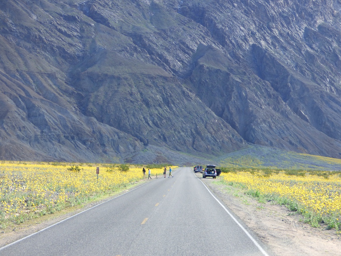
So it was that we found ourselves driving the entire length of the southern half of Death Valley so we could then make our leisurely geological explorations one after another on the way back. This plan gave us an overview of the geology of the valley, but it also gave us a dramatic view of the opening stanzas of the "superbloom". It was running weeks earlier than normal. Most years we see few, if any flowers at all. If this had been a trip with just Mrs. Geotripper and I, we probably wouldn't have even made it to the south end of the valley before sunset. We would have stopped too much! But we had geology to do, so these are drive-by shots of the flower show.
Headed south from Furnace Creek towards Badwater Basin
The graben (fault basin) of Death Valley has 11,000 feet of relief, exposing two vertical miles of the Earth's crust. Although the valley is very youthful in the geologic sense (only a few million years), erosion of the surrounding mountains has filled the fault basin with as much as 9,000 of silt, clay and salt (the basin is closed, not able to drain to the sea; much of it is below sea level).
It is so very strange to see the alluvial fans that are usually so barren turning green and yellow with life. The flowers increased in number as we moved south, I assume due to better exposures to sunlight. It seems to happen that way the few times I've seen plentiful shows of color.
It's a wondrous show, and park visitors were in sort of a trance. The kind of trance that causes them to wander aimlessly across busy highways without looking around for oncoming traffic (like heavily loaded college vans).
As we approached Shoreline Butte and the offset cinder cone, flowers covered much of the valley floor, and climbed far up the alluvial fans. Maybe flowers cover these surfaces more often in the main flower months of March and April, but I can't remember seeing them in February when we are usually there.
Shoreline Butte itself was covered with flowers. The butte is a cinder cone that has been shaped by the waves of Lake Manly, the ice age freshwater lake that once filled Death Valley 600 feet deep. The lake was present most recently about 20,000 years ago.

So, you are wondering, did we stop AT ALL where we could see some flowers up close? Why yes, yes we did. I made sure that some of our geology stops would require walking through the fields of Desert Gold, Five-Spot and Phacelia. Pictures will be coming soon!

Friday, March 11, 2016

Rainfall milestone this week in my corner of California

We reached a milestone this week in my backyard (backyard in both the literal and figurative sense). We reached "normal". I've been tracking rainfall totals in my backyard since 1991, and up until 2011, the average yearly rainfall has been 14.67 inches per year. The last four years of drought brought the average down to 13.92 inches, but the last nine days have brought us 2.98 inches of rain, and the year's total now stands at 14.51. It's the first time we've reached "normal" in five horrible dry years. Another storm will barrel through the area on Sunday.
There were great hopes that the El Nino event, the strongest ever recorded, would have brought us far more than normal rainfall, but that is seeming more and more unlikely. I'll take normal any day, though, and the region around is reaping a bounty of moisture. It will be a banner year for wildflowers in the canyons and foothills of the Sierra Nevada, and the prairies around my home are already colorful in places. Death Valley has experienced a rare "superbloom", which I was privileged to witness (pictures coming soon).

A very dry (and very warm) February raised the specter of an early melting of the snowpack in the high country, with only one significant storm. A similar situation last year left us with 5% of normal snow in April. We had dropped from a surplus of 110-plus percent to something like 80 % of normal. The March storms dropped five feet or more of snow in many parts of the High Sierra and Cascades, so there's good news in the high mountains too.

Is the drought over? Not by a long shot. The rain and snow are significant, but the groundwater and soil conditions will take a long time (if ever) to recover. The reservoirs of California, with just one exception, are still well below normal. Some reservoirs have a decent chance of filling this year, but there is a long way to go before we can make up the deficit of the last five years. One of the problems is that a reasonably wet year can cause consumers to relax their efforts to conserve, and one of the real problems of our state is that even a normal year no longer provides enough water to meet all the demands. A political conversation needs to happen about our way forward. With global warming, droughts may very well become more frequent, and a return of "megadroughts" lasting decades are a possibility (two megadroughts in the last 2,000 years lasted upwards of a century each).
http://cdec.water.ca.gov/cgi-progs/iodir/B120UP

Arizona is Going to Get Another Meteor Crater, Only Bigger. And We Know Where and Why (repost)

This is a repeat of a post I wrote in August of last year because the issue is still in the news, and represents a piece of political larceny that should disqualify Senator John McCain from ever being re-elected. Democrat Representative Anne Kirkpatrick shares blame here as well. When I see a representative insisting that a law must be followed ("Rep. Gosar is pressuring the Forest Service to enforce its rules that limit camping at Oak Flat to 14 consecutive days") when he helped subvert law to bring this situation about, I feel sick about our political system. The August post follows:
This is NOT a killer asteroid entering the Earth's atmosphere. It is a sun dog over Oak Flat Campground near Superior, Arizona. Oak Flat is going to become a gigantic crater.
Because it won't be a meteor that causes it. It won't be an atomic bomb test. And it won't be because of aliens like those stupid ones in Indiana Jones and the Kingdom of the Crystal Skull. The giant crater will be entirely the work of human beings, and gravity. And it will destroy a place that is sacred to many, and was given protection by a Republican president 60 years ago.
Meteor Crater, Arizona is probably the most famous impact crater on the planet, and is about three-quarters of a mile across, and about 550 feet deep. The coming crater is expected to be about a mile across, and as much as 1,000 feet deep. How in the world is such a thing going to happen?
The town of Superior, Arizona is like many old mining towns of the west. It's depressed, it's poor, and few inhabitants really have a reason to stay. People made a good living out here at one time, mining and smelting copper from huge open pits nearby. But the mines closed decades ago.

But the copper wasn't all gone. With prices up, there is renewed interest, and Resolution Mining Company has outlined a huge ore body, one of the largest in the world. But there's a problem.
It's 7,000 feet beneath the surface.

The normal approach, open-pit mining, won't work. It's far too deep. Normal tunnel mining won't cut it either, because although the ore body is huge, it is low-grade, averaging around 1.5% copper, instead of the 5% or so that is required for profitable tunnel mining. So the company proposes to go after the ore using a process called panel caving (a type of block caving). They propose to start underneath the ore body, design a system of collection tunnels, and then fracture the rock above, allowing it to fall into the collection areas where the ore will be removed.
The process will allow the mining of vast amounts of ore, but what they will be doing will amount to removing an entire mountain from beneath the surface. Holes of such size cannot be maintained as open space underground, so the mine will collapse in a supposedly controlled manner. At the end of the mine's usable "life", the crater is expected to be about a mile wide and as much as 1,000 feet deep. Bigger than Meteor Crater.
There are huge social and political issues. Many people are fully supportive because money, but it's never entirely clear who will truly benefit, and who will actually get the jobs, and which political entities will get the tax revenue to support the regional infrastructure. And there is no guarantee that the mining company itself will maintain economic viability for the next sixty years. Such things are hard to predict, and the American West is littered with abandoned and depressed towns that were promised much and ultimately received little.
And then there is the matter of honor and history. Soldiers chose to die here, defending their homeland and families. When all was lost, more than four dozen of them chose to jump off the cliffs rather than be taken by the enemy. It was around 1870, and the deaths occurred only 1,500 feet from the edge of the proposed crater.

If the soldiers were U.S. military, I suspect there would be a cacophony of voices raised in righteous anger about the desecration of hallowed ground, and historical heritage and all that. But no, the warriors were Apache. The copper mining company insists that they respect the Native American heritage, and they make all kinds of public relations noise, but a great many local tribes and nations are deeply opposed to the operation.
I'm okay with weighing the pros and cons of a project like this, assuming that all parties are heard, and their concerns dealt with. But there has to be a willingness to say no, that some places should not be destroyed for the sake of profits over all other factors. I'm disturbed when those with the money are the only ones heard in the discussion and that there is an assumption that it will go forward no matter what. But ultimately politics requires a fair and open vote in Congress. And that's where the problem lies. The project will require a land swap that gives up federal land for "ecologically sensitive" lands elsewhere. And Congress has turned it down a number of times.
So in a bit of bipartisan corruption, the land swap was placed in a piece of legislation, the National Defense Authorization Act (NDAA) that had to be passed in 2014. It was a betrayal of trust on the part of people like Senators John McCain and Jeff Flake (speaking of corruption, Rep.Rick Renzi is in prison over crimes related to the land swap; and Senator Flake was once a lobbyist for Rio Tinto, one of the mine's corporate partners). This is the kind of political shenanigans that tells me that these plans need to be tabled for awhile. This isn't the way things should be done in our society.
How badly do we need this copper, really? And at what true cost?

For an excellent summary of the issues involved, please read this excellent article by Ray Sterns for Phoenix News-Times: http://www.phoenixnewtimes.com/news/a-copper-mine-near-superior-is-set-to-destroy-a-unique-sacred-recreation-area-for-fleeting-benefits-7287269

Saturday, March 5, 2016

Ego-systems and the Great Valley: No, that's not a misspelling, it's poetry

I've been meaning to get to this for awhile. I had the privilege a few weeks ago of attending the 2016 Gala fundraiser for our local treasure, the Great Valley Museum of Natural History at Modesto Junior College in California's Central Valley. The museum building is new, having opened only two years ago, but the museum has existed for more than thirty years in less than favorable quarters. The museum today is five times larger and includes a Science on a Sphere, a planetarium, a pendulum, and great exhibits displaying the natural history of our valley. It is a marvelous community resource that is a great place to visit. It will continue to grow with the opening in a year or two of a large outdoor education laboratory rising from the barren lot north of the present museum.

We further had the privilege of hearing a reading by Sam Pierstorff, past Poet Laureate for the City of Modesto, Professor of English at MJC, and recent American Ninja Warrior. His poem on "Ego-systems" was a treat.

EGOLOGY: THE STUDY OF EGO-SYSTEMS
—A poem for the Great Valley Museum, February 20, 2016
by Sam Pierstorff

If you have never laid on the sandy shore
near Long Lake in the Emigrant Wilderness
and looked up at the black expanse of sky
dotted with stars like crystal tears, then you may
still believe that you are the center of the universe.


If you’ve never crossed the African Savanna
in a rickety jeep, binoculars bouncing around
your neck as you spy a pride of lions as they rip
bone and flesh from a zebra, then you might believe
that you are at the top of the food chain.


Newsflash: The Butterfly Effect is not about you.
No tsunami ravishes Japan just because you winked
at a cute barista at Starbucks. Neither is an earthquake
in Nepal the result of the fit you threw when she forgot
your whipped cream and extra shot of espresso.
 

But if you still can’t believe that the world
does not revolve around you, then come here.
Let the Great Valley Museum reveal the eco-system
that keeps you alive, and let it extinguish the flames
of your ego-system that consumes you with lies.


You are not one-celled algae, but you are certainly
not a blue whale, not an acorn nor a valley oak,
not a feral kitten eating tuna from an old sandwich
nor an African lion with a mane like spun gold.


You, like all of us, are part of an interdependent
web of life. We need each other like the soil
needs the sun, like a book needs a reader, like a student
needs a teacher, like this valley needs a museum
to shine a spotlight on the wonders of the world
like the way it holds us up even when we let it down.


Here—in the heart of the Central Valley
where education and potential pulse
through the veins of every person
who walks through the doors
of this Great Valley Museum—
you will finally learn to love
something greater than yourself.


The Great Valley Museum is a marvelous resource for our community, built by our community, and staffed by employees and a dedicated group of volunteers from our community. It's the best of Modesto! If you ever come by on your way to Yosemite or Tahoe, the museum is a short distance from Highway 99 and is worth a visit, and it will soon be even better.


Thursday, March 3, 2016

Volcanic Violence and California's Most Endangered Habitat: The Vernal Pool Prairie

The green hills of California's prairie barely conceal a horrific violent past. Around 20-23 million years ago, huge volcanic eruptions shook the western part of North America. Ash (pulverized volcanic rock) blasted into the atmosphere in unimaginable volumes, 100 cubic miles or more. Some of the ash was driven into the upper atmosphere, to be spread around the world with the wind currents, but much of it settled in layers that covered tens of thousands of square miles. Living things would have been buried at best, incinerated at worst. Any one of these events would have been a catastrophe. But there were many of them.
Some of the ash clouds rolled off of highlands that once existed in central Nevada and flowed west into California and down the western slopes of the slowly rising Sierra Nevada. These ash deposits are called the Valley Springs formation, and this rock still influences life in the present day.
The ash eruptions subsided, but new volcanoes developed at closer quarters, near or just east of the present-day crest of the Sierra Nevada. An occasional lava flow reached the lower foothills of the Sierra, but more often, it was a volcanic mudflow, or lahar, that came to inundate the landscape. The rocks today are called the Mehrten formation. Numerous animals lived on the resulting river floodplains and lakes, include tremendous six-foot long salmon (with "tusks"), and tortoises the size of their Galapagos cousins. Mastodons, horses and camels wandered the plains, chased by fearful carnivores, including the ancestors to the Sabertooth cat.
The geologic violence subsided, and erosion has subsequently smoothed off the hard edges of the volcanic rocks. In the semiarid climate, it is mostly grass and annuals that grow here, although the occasional oak survives in the barren landscape. The volcanic rocks contributed to the unique habitat that exists here today, providing through the weathering process copious amounts of clay.

Most of the minerals in ash will decay over time into one of the clay minerals. Soils that develop at the surface tend to be clay-rich, or clay may be present just below the surface, forming an impermeable barrier that prevents water from percolating into the ground. Because wind can blow out hollows, and because clay-rich layers can differentially settle, small pools of water may remain after major winter rainstorms. Because the water can't percolate, it doesn't disappear until it evaporates. The resulting ponds are called vernal pools. The pools are one of our more unique and unusual habitats in California.
A large number of species of plants and animals have evolved to survive in this environment that swings wildly from wet to dry within a period of weeks, and many of the species are endemic to the state. Colorful wildflowers bloom quickly in the drying rings of the "shores" of the little ponds, growing and setting seed before the water has completely dried up. The seeds can repose in the soil for years at time when drought dominates the landscape. Frogs and other amphibians may burrow into the soil and estivate (remain inert) for months on end, waiting for the rains to return.
We spent a delightful afternoon out on the prairie last weekend. It's not too hard because our village lies on the edge of the grasslands. We traveled Willms Road south of Knights Ferry near Highway 108. The spring flowers were just beginning to make an appearance following a warm dry February. There had been fears that this was the end of our rainy season, but a number of vigorous storms are on tap for the next two weeks, so the pools may be filling again for awhile.
Many birds call the prairie home. We felt especially lucky to see a pair of Great Horned Owls in a hollow along an ephemeral creek. The Valley Springs formation is soft and easy to excavate, but the holes are architecturally sound.
A Savannah Sparrow favored me with a pose on a fence next to the road. It was the first time I've had a chance to photograph one.
It was also the first time that I captured a Horned Lark. I thought at first that it was a Western Meadowlark, but I realized the markings were all wrong.
The Meadowlarks were certainly out and about, though. We could hear them all along our drive. At this time of year, they're looking for mates, and aren't at all bashful.

It was a beautiful afternoon in a serene "wilderness" (these are really private ranchlands), but we were also chastened by the sight of thousands of acres of new almond orchards that have been planted just to the west. The water for the trees is coming from irreplaceable groundwater aquifers, and when they have been sucked dry, the almonds will die away. In the meantime, hundreds if vernal pools will have been destroyed.

Monday, February 29, 2016

The Age of a Mountain versus the Age of (the rocks of) a Mountain: Arriving in Death Valley National Park

Death Valley is the largest national park in the lower 48 states, and in fact is bigger than several states. It preserves some of the most spectacular corners of the Basin and Range province, a region that extends from eastern California, all of Nevada, and half of Utah. The park includes the lowest place in North America, the hottest place in the world, some of the greatest relief in North America (the difference between the highest and lowest points, over 11,000 feet), and some of the rarest and most endangered animals (the pupfish and others). And awe-inspiring scenery!

We entered Death Valley from the west, driving over the Darwin Plateau at the south end of the Inyo Mountains. Just beyond the summit we stopped briefly at the Father Crowley Vista Point, which overlooks a deep desert valley that isn't Death Valley. It's Panamint Valley, another faulted basin only a bit less deep than Death Valley itself. The setting sun highlighted the rocks exposed across the valley in the Panamint Mountains. Thousands of feet of limestone and sandstone were visible, exposing evidence of more than 100 million years of quiet deposition of mud and sand on the western margin of the North American continent during the Paleozoic Era
It was a good moment to draw a contrast between the age of a mountain range and the age of the rocks exposed within the mountain range. These are two different things. The rocks of the Panamint Mountains formed over a  period of many hundreds of millions of years, but the mountains themselves are very young (geologically). Lava flows on top of the now separated mountain ranges show that they were once connected, and that the valleys could only have formed in the last few million years. The Panamint Mountains are one of the youngest mountain ranges on the planet! By comparison, the Rocky Mountains are around 50 million years old (with some recent rejuvenation), and the Appalachians are 300 million years old (with a complex story that played out over tens of millions of years). India began slamming into Asia 40 million years ago, forming the Himalayas. The earliest Hominids, had they cared to, could have seen Death Valley before it became an actual valley.

As the shadows lengthened, we crossed Towne Pass at 4,956 feet (1,511 meters), and descended the long grade to our our sea level camp at Stovepipe Wells. We had reached the actual Death Valley. Would there be geology? Would there be flowers? Stay tuned!