Showing posts with label Badwater Basin. Show all posts

Thursday, February 22, 2024

Echoes of a Watery Paradise in a Forsaken Hellscape - The Brief Return of Death Valley's Lake Manly

Imagine a lake that's six miles across flanked by dramatic mountain peaks reaching heights greater than 10,000 feet. We're in California, so it's got to be Lake Tahoe, right? But it's not. It is the lowest and driest place in North America, and the hottest place in the world. It's Death Valley. And big lakes are not a normal part of the scenery here. Badwater Basin is normally a dry salt flat. What has happened here?
In a word, it's rain. An extraordinary amount of rain has fallen in and around Death Valley this year, around 300% of what is normal. That sounds more dramatic than saying that 4.8 inches has occurred so far. A "normal" year to this point would see about 1.5 inches. And the rain did not fall in Death Valley alone. Death Valley is the lowest basin in a very large drainage system, and the surrounding landscape received even more. It was primarily the result of two events: the remnants of Hurricane Hilary in late August 2023 provided the floodwaters that resulted in the first iteration of the lake. In the hot months that followed, much of the accumulated water evaporated, but then the first week of February brought an atmospheric river storm to California that rejuvenated the shrinking lake. We were lucky to arrive a week later.

This kind of thing doesn't happen often. Some water was present on the valley floor in 2010, and earlier in 2005. But both of those years, floods had damaged the road to Dante's View so I haven't had a birds-eye view of the lake in at least three decades. It was fantastic.

When I and my students travel to Death Valley they get a packing list, but I tend not to put 'kayak' or 'raft' on that list. But we knew the lake would be there, so our long-term friend and trip volunteer Ryan actually packed one, so we had the spectacle of the Hollister family rafting Death Valley. 

The lake has been in the news, so we weren't surprised to see a multitude of tourists gathered in the parking lot at Badwater. I didn't think they'd all opt to go walking in the slimy muddy salty water, but you can see that they did. I was much happier to have stopped along the lake a mile to the south where there was no one but ourselves.

It was along that quiet shoreline that I was able to hear the echoes of a distant past when Death Valley was a watery paradise rather than the hellscape it is today (albeit a very beautiful and dramatic hellscape). That is what is revealed by the geological evidence scattered along the normally parched lake margins. 


At the south end of Death Valley there is an old basalt cinder cone with a strange name: Shoreline Butte. In the picture above, the shoreline terraces are highlighted by the "Superbloom" of 2016 (with all the rain this year, there is at least a possibility of another superbloom in a few weeks). Each of those horizontal terraces was carved by wave action. This and other clues scattered around the margins of the basin are evidence of a lake that existed here for thousands of years. It was as much as 600 feet deep, and more than 100 miles long. 

Where did all that water come from?

Along Beatty Cutoff Road, there is a beach berm covered by rounded flattened pebbles. This was along the northern shoreline of Lake Manly when it was 450 feet deep.
Evidence suggests that Lake Manly existed during a period from 186,000–120,000 years before present, dried up, and then returned again between about 35,000 to 10,000 years ago. It can't be a coincidence that these dates are identical to the dates established for the Tahoe and Tioga stage glaciations that took place in the Sierra Nevada. No glacier ever reached Death Valley, but the Sierra glaciers contributed vast amounts of meltwater to the dry basins east of the mountains. These waters filled present-day Mono Lake to overflowing. It spilled over and flowed in the Owens River to Owens Lake, which actually persisted into the modern era when LA water diversions caused it to dry up in the 1920s.

Pluvial lakes of Eastern California. Source: Philip Stoffer of the U.S. Geological Survey

Ice-age Owens Lake reached a depth of 300 feet and spilled over into China Lake, then Searles Lake, Panamint Lake, and finally Lake Manly in Death Valley. These ice-age bodies of water are called pluvial lakes. The cooler wetter conditions allowed two other river systems to contribute water, the Amargosa River out of Nevada, and the Mojave River out of the San Bernardino Mountains in Southern California. There may have even been a temporary connection with the Colorado River, which resulted in one of the most surprising aspects of Death Valley biology: fish!

Salt Creek Pupfish from the middle of Death Valley

Yes, there are fish in Death Valley! In fact, there are several species. They survive in widely scattered springs and short stretches of perennial streams that exist in the desert. The pupfish (cyprinodon) are of particular interest because they probably once were a single widespread species, but when isolated in springs that were either hot or cold, or salty or fresh, they were forced to evolve or perish. Today there are four species in the confines of the park and several others in outlying areas, especially the Owens Valley and Ash Meadows in Nevada. I've found their story to be intriguing and I've written about them a number of times. These diminutive fish survive in the saltiest and hottest water of any known fish species.

Mammoth bones on display at the Shoshone Museum, east of Death Valley

Imagining this vast ice-age lake meant led to another vision of past worlds. In the early 1980s, some students on a geology field trip were hanging out near their camp in the Shoshone area when they discovered bones sticking out of a gully wall. These bones proved to be specimens of Columbian Mammoths and other ice age mammal species (the specimens are currently on display in the Shoshone Museum east of the park). The Death Valley region was a much cooler and more verdant environment during the ice ages, and the shoreline of Lake Manly was populated by grazing animals including the aforementioned mammoths, camels, horses, bison, and the carnivores that would have preyed upon them, including the large cats and perhaps relatives to today's wolves and coyotes.

Looking at the shore of Lake Manly at Badwater from a vertical mile above from Dante's View
To see a lake that only comes into existence every decade or so is a spectacle (in the best sense). But to understand the deeper implications suggested by these lakes that speak of past worlds is the magic of geology. See it if you can. It won't last much longer!

Friday, March 25, 2016

A Sight That Overwhelms: Dante's View and a Sense of Scale

It's one of the most astonishing viewpoints in all of North America. The Black Mountains form the eastern edge of Death Valley, and they are one of the most rugged mountain fronts in existence. In places the mountains are so steep that one cannot see the slopes at the base from the summit. Looking up from the lowest point in North America, Badwater, one can barely contemplate walking or driving to the summit across the barren cliffs.
And yet a road does just that. Taking advantage of the asymmetrical nature of the range, a paved road winds up the eastern flanks, and only the last few hundred yards of the drive are a vertiginous nightmare. And then there is a view like no other.
Death Valley is the largest national park in the lower forty-eight states, and Dante's View takes in much of the park, offering on clear days a view that extends across more than a hundred miles of desert ranges and salt flats. The view is so unlike any other place on the planet that George Lucas used it as setting for his alien planet in some movie about wars across the stars ("Mos Eisley spaceport. You will never find a more wretched hive of scum and villainy.").
Even though the summits reach nearly 6,000 feet above sea level, the slopes are barren and dry. The range lies in the rain shadow of the Sierra Nevada and two other high mountain ranges, including the Panamints that rise to 11,000 feet on the other side of Death Valley. In any other mountain range, 6,000 feet would support a thick forest. Here in the Black Mountains, only sage and seasonal wildflowers can grow.

The lack of vegetation is a boon to the geologist, of course. The exposures of bedrock are unparalleled, revealing a great deal about the geologic history of this part of the world. And it is a strange story. Much of the mountain range is composed of the Black Mountain Metamorphic Complex, a selection of gneiss and schist sequences that reveal evidence of a titanic series of plate collisions 1.7 billion years ago. At that time, North America was hit by a series of terranes, island systems maybe the size of New Zealand or California. The collisons produced a mountain range hundreds of miles long that would recall the coastal ranges of southern Alaska, minus the rainforests (terrestrial life didn't arise for at least another 1.2 billion years). These rocks are related to those found in the depths of the Grand Canyon and farther south in Arizona and New Mexico.

In the ensuing years, the vast range would be eroded to a nearly flat plain, and the surface would eventually subside below sea level. Tens of thousands of feet of Paleozoic sediments covered the rocks so they lay hidden deep in the continental crust. In the last few tens of millions of years, the regional crust was stretched and extended, and the overlying rocks slid away, causing the Black Mountains to "pop up" in the geologically short stretch of two or three million years. The exposure of the deep crust was accompanied by violent caldera eruptions, and parts of the mountain range are covered by colorful ash deposits (the rocks along Artists Drive Loop are particularly memorable).
Some places are so overwhelming that one can lose a sense of scale while staring into the abyss. Take a look at the picture below: we are looking at the vast salt pan of the Badwater Basin, the lowest place in North America at minus 282 feet. The salt flats cover 110 square miles. How big an area is this?
To find out, take a look at the thin channel of salt marked with the arrow in the picture above. We'll zoom in a bit, and find that we are looking at a spot next to the Badwater parking lot, which is just out of sight at the bottom of the picture. One can make out the Badwater Road on the left side of the photo. What are those dots on the salt channel? Let's zoom in a bit more (120x by now).
They're tourists! Badwater is a main destination for visitors to Death Valley. The stop lies 5,700 feet beneath Dante's View, and only two miles west. These mountains are about as steep as any can be.
The view from Dante's View on this afternoon in February was unique for me. Flash floods in October had destroyed some roads in the park, and I found it necessary to alter our usual itinerary. We usually see the viewpoint in the early morning. Until this day I had never seen the sun set over desert like this. It was an astounding sight. Even overwhelming...

Sunday, March 13, 2016

Invitation to a Drive-by Shooting (of a Superbloom) in Death Valley

Telescope Peak (11,043 feet) and the Death Valley graben and salt pan
Death Valley is one of the greatest geological national parks in the world. The largest U.S national park outside of Alaska, it exposes 1.7 billion years of earth history, with incomparable exposures of igneous, sedimentary and metamorphic rocks covering every geological era from the Proterozoic to the Cenozoic. Grand Canyon National Park has the reputation as a geological encyclopedia, but the exposures at Death Valley are more than twice as thick!  
Scarp of the Furnace Creek fault zone north of Furnace Creek Resort
My students and I make a trek to Death Valley every February on the President's holiday weekend. Our focus of course is on the geology, but this year involved some biology. Although Death Valley is one of the driest places in North America, when rain does come, seeds in the desert soils are waiting. When conditions are just right, maybe once a decade, there is a "superbloom" of desert wildflowers. There were the El Nino years 1998 and 2005, and there is now the El Nino year of 2016.
Panamint Mountains on the west side of Death Valley, with the gulch of Salt Creek on the valley floor.
The weather events have been extreme at times. A flash flood at the north end of park laid waste to the grounds at Scotty's Castle and eradicated a major highway. The usually dry desert wash had a flow estimated at 9,000 cubic feet per second. For comparison, the Tuolumne River back home is considered at flood stage with a flow of that magnitude. Imagine unleashing such a flow on a dry wash, add tons of mud and boulders, and you get the idea. Another flood wiped out the highway from Shoshone over Jubilee Pass into Death Valley. We had to change our normal itinerary in a big way.
North end of the Black Mountains in the vicinity of Furnace Creek
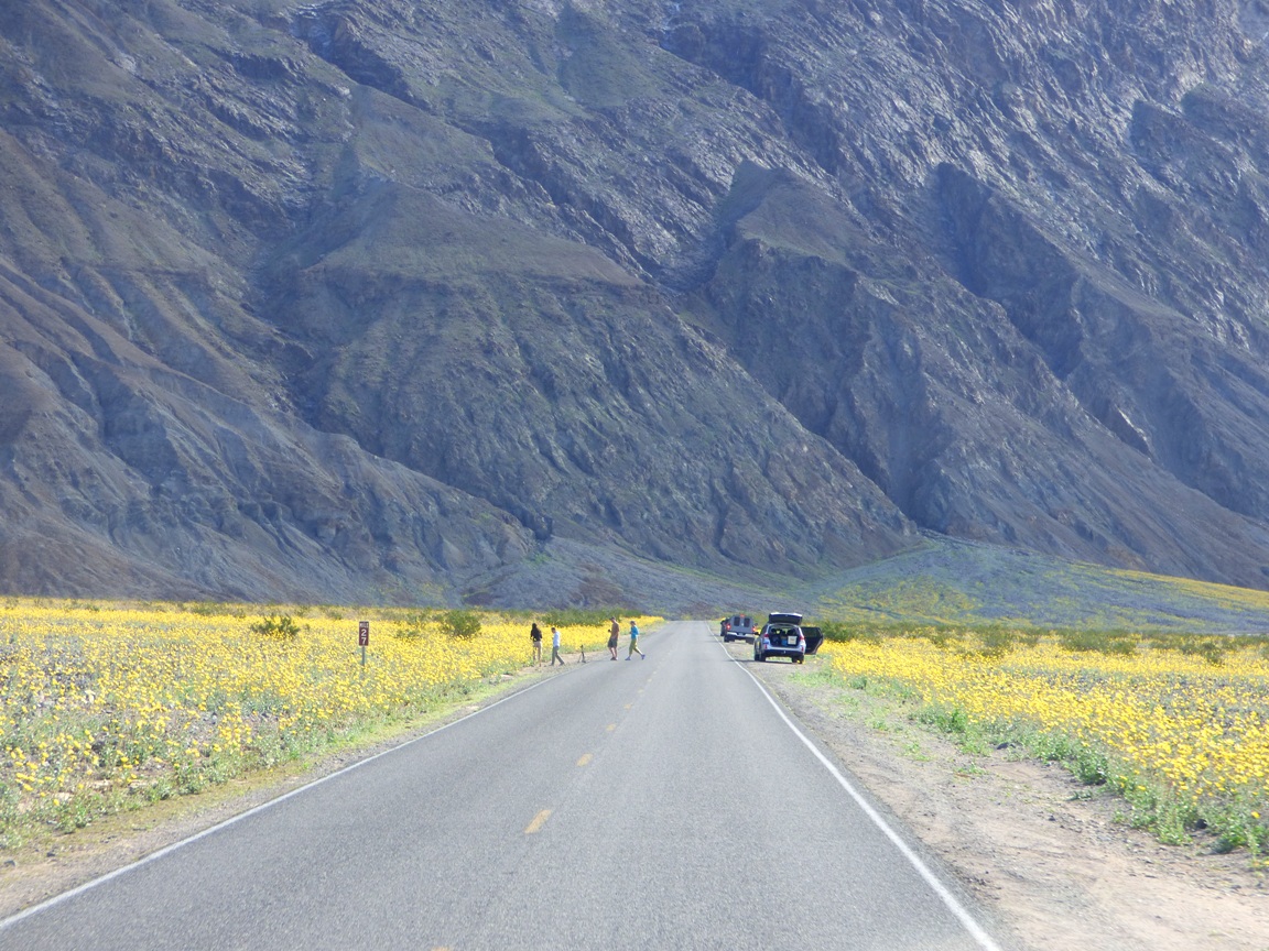
So it was that we found ourselves driving the entire length of the southern half of Death Valley so we could then make our leisurely geological explorations one after another on the way back. This plan gave us an overview of the geology of the valley, but it also gave us a dramatic view of the opening stanzas of the "superbloom". It was running weeks earlier than normal. Most years we see few, if any flowers at all. If this had been a trip with just Mrs. Geotripper and I, we probably wouldn't have even made it to the south end of the valley before sunset. We would have stopped too much! But we had geology to do, so these are drive-by shots of the flower show.
Headed south from Furnace Creek towards Badwater Basin
The graben (fault basin) of Death Valley has 11,000 feet of relief, exposing two vertical miles of the Earth's crust. Although the valley is very youthful in the geologic sense (only a few million years), erosion of the surrounding mountains has filled the fault basin with as much as 9,000 of silt, clay and salt (the basin is closed, not able to drain to the sea; much of it is below sea level).
It is so very strange to see the alluvial fans that are usually so barren turning green and yellow with life. The flowers increased in number as we moved south, I assume due to better exposures to sunlight. It seems to happen that way the few times I've seen plentiful shows of color.
It's a wondrous show, and park visitors were in sort of a trance. The kind of trance that causes them to wander aimlessly across busy highways without looking around for oncoming traffic (like heavily loaded college vans).
As we approached Shoreline Butte and the offset cinder cone, flowers covered much of the valley floor, and climbed far up the alluvial fans. Maybe flowers cover these surfaces more often in the main flower months of March and April, but I can't remember seeing them in February when we are usually there.
Shoreline Butte itself was covered with flowers. The butte is a cinder cone that has been shaped by the waves of Lake Manly, the ice age freshwater lake that once filled Death Valley 600 feet deep. The lake was present most recently about 20,000 years ago.

So, you are wondering, did we stop AT ALL where we could see some flowers up close? Why yes, yes we did. I made sure that some of our geology stops would require walking through the fields of Desert Gold, Five-Spot and Phacelia. Pictures will be coming soon!

Tuesday, June 2, 2015

Weather a Bit Less Strange? Death Valley in the Last Two Days: Hot!


There is, of course, hardly such a thing as "average" weather, just like there is no "average" precipitation. I'm pretty sure that the number of days in a given year that actually match the average temperature is  limited. I've been to Death Valley twice in the last two weeks; for Memorial Day weekend, when the temperatures were very cool, like twenty degrees below average, and rainy. I was back there during the last two days, and conditions had taken a thirty degree swing in the other direction, hitting as high as 118°f on Sunday afternoon. It cooled to only 87°f overnight. Average for this time of year? 105°f for the high, and 77°f for the low.
I like to think of myself as a desert rat since I'm out there seemingly all the time, but it's not exactly true. I visit deserts most often when they are a great deal more amenable to human existence. Like Death Valley in winter. I live in a place that gets plenty hot sometimes in summer, but the term "hot" is defined by temperatures topping 100°f maybe a dozen days over the summer. The hottest temperature we've ever had at home was 113°f. So spending an afternoon at 118°f was a new experience. It wasn't fun. I don't like thinking about having a vehicle breakdown in weather like this, especially since cell phone coverage is very sparse in the park.
It's funny how pictures don't really communicate how hot it is. I stepped out of the car for just a few moments, and the heat hit me like a hammer. I know one can get used to conditions like this, but it takes time, and there are limits. A former student of mine worked as part of a public safety team in Death Valley in summer and described the delightful experience of answering emergency calls in full emergency gear. When it was 124 degrees...
The sun had sunk behind the Cottonwood Mountains, but the temperature barely budged. Despite the heat, a few people were out on the dunes, but they didn't venture far from the parking area. For the first time in twenty-five years of visiting Death Valley I noticed there were no footprints on the highest dune. It was just too darn hot to go that far.
It begs the question then: what the heck was I doing visiting Death Valley in almost-summer? The first visit is easier to explain. I had scored reservations for two nights camping on the North Rim of Grand Canyon National Park (a late cancellation no doubt; the next available dates are in August). That was for Memorial Day and the Tuesday after. But we had to get there somehow with no reservations for any place between my Great Valley in California and Grand Canyon. We looked at the weather report for Death Valley and saw that temperatures would be far below normal, so we decided to give camping a try at Furnace Creek. It worked out nicely although it spritzed rain and was windy on the second night. We were comfortable enough.
The second visit was for a more unusual reason. The BBC is working on a documentary on the science of color, and they wanted to use the salt pan at Death Valley National Park as a natural setting for the color white. The crew was already headed to the states when they decided they wanted a geologist to explain why the salt is present in Death Valley. Their staff member contacted the folks at AGI (American Geological Institute), and someone there contacted the former director of the NAGT (National Association of Geoscience Teachers), and he remembered something about me visiting Death Valley all the time. The BBC folks were delighted to find out that I was traveling that general direction and asked if I could meet them Sunday at Badwater.
We met up, but there was a problem. The Badwater salt pan wasn't white! It was mostly a dirty brown color. It seems that California's four year drought has even had an effect in Death Valley, a place that is already the driest spot in North America. In wet years, the Amargosa River (a usually dry water course that drains much of western Nevada) may flow enough to fill the Badwater Basin with a foot or so of water. The clay settles, the water evaporates, and salt forms a white crust. But there hasn't been a flooding event since 2010 or so, and dust has blown across the surface of the playa (dry lake bed) in most places.
It turns out there were a few fairly wide expanses of white salt to the south of Badwater. There haven't been the flooding events, but there are still springs along the base of the Black Mountains that flow onto the floor of the valley and keep the clay wet. Salty water rises through the clay by capillary action, and the moment the water reaches the surface it evaporates, causing the salt to precipitate on the surface of the clay, forming a thin crust. It's not quite like the inches or feet of salt seen at Badwater or the Devil's Golf Course, but it was white and covered several acres, so with a bit of forced perspective, the white surface could be made to seem cover a vast area. We headed out there.
If you look carefully, you can see our cars in the distance, a bit right of center.
It was a bit cooler in the morning, the high 80s, and the temperature was expected to top out at only 110 degrees. That could be a complication, because the film crew was accompanied by a park ranger who was ordered to shut down filming if temperatures exceeded 110 degrees. No exceptions.
The host of the documentary and I headed out to the salt pan. The sediments of the alluvial fan were cemented with salt and the footing was firm, but as soon as we reached the salt itself, we were actually walking in mud with a thin crust of salt. Any concerns about the temperature were eased, sort of, by the fact that the wind was howling at 20-30 mph or more, and that kept the temperature from soaring. Of course it also made a discussion of the geology difficult to record on the sound equipment.
I have my dependable desert hat that has never been blown off my head, but I lost it repeatedly out there. I eventually gave up and did the interview without it. I was discussing geology in the middle of a desert windstorm with the temperature wavering around 110 degrees on a salt flat with a relative humidity approaching zero percent. I went through three water bottles in the two hours we were out there and still got a bit dehydrated.
Still, the crew knew what they wanted to accomplish and worked very efficiently. I even got to walk in a circle next to the sound boom so they could have the sound of my boots crunching on the ground. It was mostly unscripted, but the host, a physicist, knew how to draw the information out of me. She asked good questions. We did three takes, and then spent a fair amount of time walking across the hot surface for atmosphere scenes. They finished my part and let me go on my way, but they stayed out there for another couple of hours. They work hard on this kind of thing!
Mrs. Geotripper spent all this time sitting with the vehicles and taking most of these pictures from a quarter mile away. Both she and I were quite hot and dehydrated, so we retreated to the cafe at Furnace Creek and drank lots of liquids, and then "got out of Dodge". We headed up Townes Pass, watching the temperature drop 25 degrees as we climbed nearly 4,500 feet up the highway (perfect confirmation of the environmental temperature lapse rate of 5.5 degrees per thousand feet of elevation). For some reason or another we ended the day at Mammoth Lakes at close to 8,000 feet. I think we just wanted to feel cold for awhile...