Wednesday, June 5, 2013

Where They Almost Damned the Grand Canyon...

 Is there a limit to the destruction that humans can do? Yesterday's post concerned our desire to control the natural world around us, which in the case of the Colorado River meant the building of mega-dams, giant piles of concrete that pretend to hold back the floods, and dole out the riches of gravitationally produced electricity. Unfortunately such mega-dams were built with a priority of utility over beauty.
Of course, hardly anyone can profit from beauty, and if only a few people know of a place or have ever seen it, it can be easy to subvert a place to the profit of a few. After visiting one of the mega-dams, we explored a little-known road that actually reaches the bottom of the Grand Canyon. It follows Peach Springs Canyon and Diamond Creek to the Colorado River in about 20 bumpy dirt road miles. It is well known to river-runners, as the road serves as a take out point for river trips.
As we cooled our feet in the water, we had to contemplate that sixty years ago, this place was slated to become the next big dam on the river. The reservoir would have inundated miles of national park land upstream. It was unthinkable, and in the fashion of the thinking of the time, the dam was built instead in a place that only a few hundred people had ever seen: Glen Canyon.

It's hard to contemplate what was lost.  And only slightly a relief to know that at least one place was saved.

Monday, June 3, 2013

A Dam Big Dam and a Dam Big Bridge...And a Dam Frightening Problem

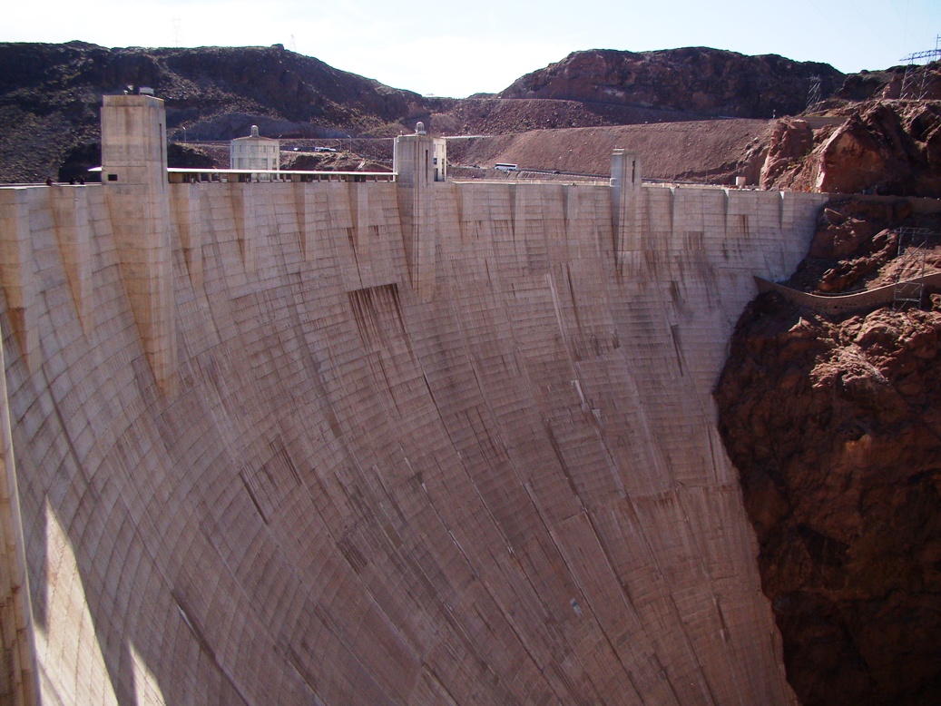
Oh, how mighty are the works of man...and how arrogant we sometimes get when contemplating our great works. Our first stop on our tour of the western Colorado Plateau was a visit  to Hoover Dam and Lake Mead, the gigantic tower of concrete that blocks the Colorado River, and holds back 30 million acre-feet of water. It's the biggest dam reservoir in the United States. How much is 30 million acre feet? More than two years of "average" Colorado River flows for one. The largest dam in our region back home, Don Pedro on the Tuolumne, holds a paltry 2 million acre-feet.

The dam was built during the height of the Great Depression between 1930 and 1935, and just two years after the catastrophic failure of St. Francis Dam in California that killed around 600 people. Lessons learned from the failure of St. Francis led to modifications of Hoover Dam which presumably make it more or less indestructable.

Just the same, it is amazing how many faults are exposed in the canyon walls adjacent to the dam. The rocks forming the abutments are Miocene volcanic tuff, which doesn't dissolve or crumble in water (a major factor in the St. Francis event). But the rock is highly faulted, and it is a great place to explain slickensides, the scratch marks that occur when blocks of rock slide past each other. The rock is literally polished.
The visitor center is guarded by giant copper art-deco angels that made me feel like I was entering the walls of Minas Tirith in Lord of the Rings.
The thing is dam big. It's more than 700 feet high, which was the highest in the world when it was built (now it is 18th). One can drive or walk across the dam thing, but it is no longer the main highway between Kingman and Las Vegas.
In 2010, work was completed on the O'Callaghan-Tillman Bridge just downstream. It towers 880 feet above the river, and more than 200 feet above the level of the dam. Walking across the top allows the incredible perspective of the dam and lake in the top photo of this post.
 Looking down the dam face is disorienting, but it looks like a great slide (although one's pants would surely catch fire from the friction...). The white thing is part of the power generating complex.
The bridge really is a stunning piece of work, although it is a bit disconcerting to feel it vibrate as the big trucks pass by...
Looking down the other face of the dam is disconcerting too. It's been a long time since the dam was full (1983 to be exact). The water level looks to be only a hundred or so feet low, but that represents perhaps half the storage capacity of the reservoir. A decade long drought has brought down the reservoir to perilous levels (13 million acre-feet), and some forecasts suggest it may never fill again. 30 million people in Los Angeles, Las Vegas, Phoenix and in many agricultural areas depend on the supply of water, but it just isn't there.

And that's dam frightening.


Sunday, June 2, 2013

Picture of Peach Springs Tuff (with Big Bird Bonus)


The Internet connection at our hinterlands location is slow and undependable, so tonight is just a picture of the Peach Springs Tuff, an 18.5 million year old rhyolite tuff that covered a vast area between Peach Springs Arizona and the Mojave Desert near Barstow. It is nicely exposed along the old Route 66 in Kingman Arizona, which was one of our stops today. There also seems to be a large fledgling bird sitting on the rock and partly blocking the view, but I found it interesting. I am assuming it is a Red Tailed Hawk fledgling. Is there anyone who can confirm or correct?

Saturday, June 1, 2013

Seeing Things Upside Down in the Red Rocks: What To Do When You Get Bored With Las Vegas

Bored in Las Vegas? Really? Okay, the town is such an aberration in the desert that one can hardly get bored, but my attention was really elsewhere as we tried to get ready to meet the people traveling with us through the western Colorado Plateau. It took only three hours to get our rental vehicles, and it took some wrangling to get the last person to the hotel from the airport, but by 4:30 we had everyone, and most of them were ready and willing to check out some geological sights west of town. We headed to Red Rock Canyon National Conservation Area.

I made an appropriate first impression by missing the turnoff to the park, and taking the crew on an impromptu crossing of the Spring Mountains. But good ole Captain Eagle-Eye Wrong-Way eventually got us back to the road we wanted, and we headed towards one of the more stunning sights in the Basin and Range Province.
The Keystone Thrust was a Cretaceous structure that developed during the Sevier Orogeny, involving a section of the Earth's crust being compressed and pushed over the adjoining rocks. Rocks brought up from the depths are often older, so at Red Rock Canyon NCA, 500+ million year old Cambrian Bonanza King Limestone got pushed up and over the younger Jurassic sediments called the Aztec Sandstone. The site pretty much defines the term "contrast". Dark limestone forms the high Wilson Cliffs, while bright colored sandstone livens up the Calico Hills
There was also a lot of green. For some reason lots of flowers were evident (despite the desert environment, we were at well over 4,000 feet in elevation). The plants had attracted all manner of bugs and beautiful hummingbirds (top picture).
From the high point on the park loop, we were treated to an awesome view of the imposing cliffs of the Spring Mountains and the Keystone Thrust.
 The rocks maybe weren't really upside down so much as out of order. But the lizard climbing on the big boulder of sandstone was definitely upside down. I wish I could climb rocks that way!

I also wish for an eventful trip this week (in a good way) as we make our way tomorrow to Peach Springs and a drive to the bottom of the Grand Canyon. More later!

Friday, May 31, 2013

From a Land of Riches to the Barrens: The Basin and Range

We set off early today on our journey of exploration on the Colorado Plateau, but to get to the plateau we needed to travel nearly 500 miles from California's Great Valley to Las Vegas, passing through some of the loneliest landscapes to be found in the United States. I couldn't help but notice how we also passed from a land flowing literally with milk and honey (dairy farms and beekeepers among the thousands of farms) to a barren landscape where life must be grasped and fought for. We crossed Tioga Pass, which despite the frighteningly dry year was still mantled with some snowfields, and into the Basin and Range Province east of the Sierra Nevada. The difference was striking.
The Basin and Range Province happened because a high plateau-like region with rivers extending from at least central Nevada to the Pacific was stretched to the breaking point. About 29 million years ago, the subduction zone that had dominated the tectonic history of the Western United States for nearly 180 million years was destroyed by a process that resulted in the formation of the San Andreas fault. The crusted extended and broke into numerous fault block mountains (horsts) and deep fault valleys (grabens). The Sierra Nevada was the largest and highest of these fault blocks and as a consequence, the mountains prevent most of the rain and snow from ever reaching the lands to the east.

The Sierra Nevada is the realm of the cool dark forests and the high glaciated peaks. The Basin and Range is a place where sagebrush reigns, and practically the only trees are dumpy little pinyon pines and juniper. It's a hard dry land. We crossed Montgomery Pass into Nevada and had a close look at Boundary Peak, which at 13,147 feet (4,007 m), is the highest point in Nevada. Ironically it is not the highest peak in the mountain range in which it is situated. Adjacent Montgomery Peak is 13,441 feet (4,097 m) tall, but as the name suggests, the state boundary falls between the two. A bit farther south, White Mountain Peak soars to 14,252 ft (4,344 m), the third highest peak in California.
It's a hard land, but that doesn't mean that life doesn't thrive. We were lucky to see some members of the Montgomery Pass herd of wild horses right next to the highway. Horses came to America with the Spaniards in the 1500s and escapees over the centuries formed naturalized herds across the west. In a sense though, these horses are returnees to a long-lost homeland. The horses evolved in North America, and migrated to Asia over the Bering Land Strait, but about 12,000 years ago they became extinct in the land of their origin.
I took a new road today, the highway through Dyer and Fish Lake Valley. It is a beautiful place, and few hundred ranchers and farmers make a living off the small streams that flow off the White Mountains and from the copious amounts of Pleistocene groundwater that lies hidden beneath the valley floor (a nonrenewable resource though; they're using up the water that arrived there during the Ice Ages).
Others tried to wrest life from the land, but in a different way. When the California Gold Rush petered out in the 1850s, hungry miners scoured the lands to the east for the next great Mother Lode. Their searches were most often futile, but a few rich mines were discovered (such as the Comstock Lode), and other towns were built on dreams of avarice, but not much more. Such was the fate of Palmetto in western Nevada. There are only a few structures remaining, carved out of the rhyolite tuff that covers much of the region. For a time, several hundred miners pitched camp here, looking for plays of valuable minerals in the rocks, but they found little and quickly abandoned the site.
The desert has reclaimed much of the old town, except a few buildings which stand only because...well, I don't know how the wall below is still standing.
The miners could look out a window and see the sometimes snow-capped summit of White Mountain Peak in the distance, dreaming of water and riches, but having neither. A barren land, yes, but rich in other ways. The geology exposed in these barren mountains is fascinating, and volcanoes and earthquakes show that the crust here is still very active.

This is one of my favorite regions on the planet...

On the Road Again, To the Mysterious Realm of the Colorado River!

This summer is all about the Colorado River, one of the most geologically mysterious rivers on planet Earth. Most rivers start in some mountains, flow onto a coastal plain, and hence into the sea. The Colorado can only be said to do the first. It starts in the Rocky Mountains, but then it follows all sorts of strange pathways, cutting through mountain ranges here, abandoning channels there, forming entrenched meanders that make the river look tens of millions of years old (which it is, in places), but then historically ending in a sea that has existed for only four million years. But it doesn't end there anymore, because humans have grabbed onto every last drop of the river, using it over and over until it dies in the desert sands, many miles from the original delta.

I have a lot to learn about this river and the landscape it flows through. I leave in about five hours on the first of three journeys this summer to explore and learn about the canyons and gorges of the river. I'm joining geologists and their families on a week long trip from Las Vegas to Grand Canyon, Bryce Canyon, Zion, and all of the fascinating places in between. If there aren't too many mistakes to correct, I'll have the guidebook available in a month or two for anyone interested in the journey.
I'll be home for a week, and in the last half of June, it will be the turn of my students at MJC to see this incredible landscape. More on that later. Then, in July and August, the fulfillment of a lifelong dream of floating down the Colorado River from Lees Ferry to Diamond Creek through almost all the Grand Canyon. My incredible brother won a slot in the private trips lottery, and is letting me come along. I can barely wait.

So the adventures start in the morning. I'll try to put up a post now and then to share in the sights.

Wednesday, May 29, 2013

Time Beyond Imagining Becomes a "Book" (or: "Where I've Been Hiding These Last Few Weeks)!

A best-seller if there ever was one! In fact, I think the first run will sell out (15 copies in the first printing, so not really a surprise). If you've been following Geotripper for very long, you will maybe have seen that one of my first blog series was called Time Beyond Imagining (link is here), and that it was a series that introduced the history of the Colorado Plateau over the course of around 70 posts. I always felt that all that writing should be rounded up into a single narrative some day, and that day kind of arrived when I decided to lead a trip through the plateau country with some geologists and their families from the American Association of Petroleum Geologists. I started on the project 18 months ago and made a lot of progress, but the first trip in 2012 was cancelled, and I so let the project simmer for awhile.
We scheduled the course again this year, and by May we realized we had enough participants to run the trip, which meant I had a strict deadline...which unfortunately coincided with the end of the semester, AND the big move into our new Science Community Center. So I disappeared more or less for the last few weeks furiously writing and rewriting a narrative and field guide for the trip. It felt a lot like finishing my thesis way back when, but back then I was taking care of an infant. This time I had a son who is an expert anthropologist who wrote an extensive section for the book on the cultural history of the region. The book and guide went to the printer this evening, and we leave for Las Vegas on Friday.
The guidebook is imaginatively called "The Geology and Cultural History of the Western Colorado Plateau, with a geological road guide to Grand Canyon, Zion and Bryce Canyon National Parks". It currently includes a section outlining the chronology of geological events and descriptions of the rock units on the Plateau, another on the cultural history of the different people groups in the western part of the plateau, and road guide for a six-day trip looping out of Las Vegas through the three national parks, and a lot of places in-between.

And there are some truly fascinating places in between! Our trip includes a journey to the bottom of the Grand Canyon on the Diamond Creek Road out of Peach Springs on the Hualapai Reservation. It will also include a visit at Antelope Canyon, a surreal labyrinth on the Navajo Reservation near Page, Arizona (picture below).
We will also explore a portion of Grand Staircase-Escalante National Monument by following the forty-plus mile long Cottonwood Wash Road along the Cockscomb Monocline, a truly spectacular drive through some really distorted rocks.
The monument also includes the beautiful Grosvenor Arches in one of the most isolated corners of the country. As recently as 1949, the National Geographic Society called their visit to the region an "expedition" (which probably elicited a laugh from the local ranchers...).
Our trip will include a visit to one of the gems of the Utah State Parks system, Kodachrome Basin State Park. It contains extensive exposures of Entrada Sandstone with dozens of strange clastic pipes that tower over the trails and campground. The trip wraps up with a tour of Bryce Canyon and Zion National Park, though with a twist. We intend to take the road to Lava Point, which gets missed by the vast majority of Zion National Park visitors. When Zion Canyon proper is sizzling hot and dry, there are cool meadows and pine forests among the sandstone cliffs, and a lot of fairly recent lava flows and cinder cones.
In general, I've written the narrative portions at a fairly basic level (I included a "geology basics" at the beginning), and the road guides as to be understood by anyone with a geology class or two under their belt.

I would hope that there would be some interest in the book and road guide, but I know I'll need to do some serious fact-checking and mileage confirmations (the numbers never quite add up right, which has been true for every guide I've written) while on the trip next week. And I also need to find a cheap way to print it, because the 160 page guide ran $30 apiece at Kinkos (I know they call it something else now, but I can't remember what!). I would love any ideas you might have!

Despite the long nights and all, I've been having a lot of fun revisiting one of my favorite corners of the planet, and I'm thrilled to be hitting the road in a couple of days (one week with AAPG, and then two weeks with my students). I'll try to post some pics from the road, and not be quite as invisible as I have been the last few weeks.