Monday, February 1, 2010

NSF Geophysicists Blogging from Haiti


I'm channeling Lee at Arizona Geology, but not all of our readers overlap, I'm sure. A team of NSF geophysicists is on the ground in Port-au-Prince, Haiti, doing some research on ground movements related to the horrific earthquake a few weeks ago. They are also blogging about their experience, and a quick look shows they are describing life on the ground for the Haiti community in the aftermath of the quake as much as they describe the GPS work they are doing. The pictures are both hopeful and heartbreaking. Check it out! And give; we can't forget Haiti just because it isn't in the headlines anymore.

UPDATE: Well worth a read; an American survivor of the earthquake writes about the country she grew to love, and the acts of bravery and kindness she witnessed after being trapped in the rubble. Haiti should not be forgotten; help them, not just by giving food for a day, but by helping them rebuild their country.

Sunday, January 31, 2010

The Other California: Lassen Peak, A Volcanic Afterthought...

Getting back to our exploration of the "Other California", those places in our wonderful state that don't always show up on the postcards, and aren't the usual tourist destinations. I break my own rules every so often, and end up visiting a popular or well-known place, but only to emphasize things that a weekend tourist might miss on a quick run-through. Such is the case today, with a visit to Lassen Volcanic National Park.

The park's centerpiece, Lassen Peak, was perhaps more famous among geologists prior to 1980, when it reigned as the site of the most recent volcanic eruption in the lower 48 states. The eruption, from 1914 to 1917 (with a little puff in 1921) included lahars (volcanic mudflows), pyroclastic surges (explosions of hot ash), and a lava flow; in short, all the things a textbook writer would want to describe. One added benefit: it didn't kill anyone (although there were a few close calls). Those of us who had our first geology class before the St. Helens eruption in 1980 learned our volcanoes from the example of Lassen Peak.

Truth be told, Lassen Peak doesn't look much like a volcano. It is a miniscule peak compared to Mt. Shasta (1/2 cubic mile compared to 108 cubic miles). Although it tops out at nearly 10,500 feet, it rises off a plateau at 8,000 feet and thus is only a little more than 2,000 feet tall (Mt. Shasta rises more like 10,000 feet from its base). Visitors looking for a classic-looking symmetrical cone surrounded by lava flows will be disappointed. Lassen is a plug dome, composed of extremely viscous dacite-rhyolite lava. It erupted about 27,000 years ago by squeezing out of the ground in a manner not unlike toothpaste. Although it is a small volcano, for a plug dome it is huge; by most reports it is the largest of its kind in the world.

Lassen Volcanic National Park has a number of famous attractions, including the peak itself, Bumpass Hell and the Sulphur Works, two geothermally active areas, and a number of beautiful lakes including Manzanita and Summit Lakes. The Devastated Area records the result of the lahar and the pyroclastic surge in the main 1915 eruption. Our next few explorations will include several cones that are among the youngest mountains in the state, and a major volcano that has gone missing.

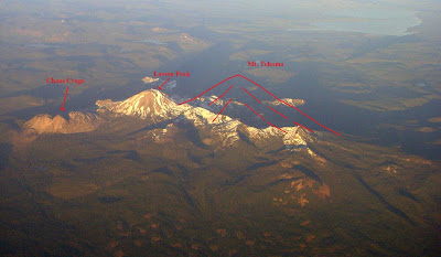
So why am I calling Lassen Peak an 'afterthought'? I'm kind of giving away the whole answer in the photo below, taken during a flight home from British Columbia a few years ago. At one time, Lassen would have been neither the tallest nor largest volcano in the park area. From about 600,000 to 400,000 years ago, that honor would have belonged to Mt. Tehama, a stratovolcano typical of the Cascades Range, similar to such peaks as Mt. Hood or Mt. Baker in Oregon and Washington. It may have reached heights of 11,000-12,000 feet. Following the last of its eruptions, the summit collapsed into a caldera*, or was simply eroded away, leaving behind a jagged ridge of peaks forming the rugged southwest corner of the national park. The Sulphur Works mark the approximate center of the extinct volcano. As can be seen in the photo below, Tehama would have dwarfed Lassen Peak.
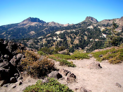
The trail to Bumpass Hell provides one of the best ground-level views of the ancient volcano. Brokeoff Mountain on the left and Mt. Diller on the right mark the remaining flanks of the Tehama volcano. The lava flows exposed on each peak slope upwards towards the former summit above the center of the picture.

If any of my California Geology students have made it this far in the post, here is a free question from our Cascades quiz in a few weeks: Mt. Tehama is the most difficult mountain to climb in California, in fact no one has ever stood on its summit. True or False?

*How's this for a volcanic afterthought? As Donald Rumsfeld famously once said, "There are known knowns. These are things we know that we know. There are known unknowns. That is to say, there are things that we know we don't know. But there are also unknown unknowns." Forrest reminds of something that I knew, but didn't have ingrained enough in my brain pathways to recall as I was writing this post. There is no evidence that Brokeoff Mountain ended in a catastrophic caldera eruption, according to the latest research. Instead, the ash tuff (the Rockland Tephra) that was thought to derive from the destruction of Brokeoff actually predates Brokeoff. The volcano didn't form a caldera, but it did grew on top of an older caldera.

Saturday, January 30, 2010

NPS Web Page Chronicles Yosemite Valley Rock Falls


Via Yosemite.blog.com, here is a link to a new web page on the rockfall history of Yosemite Valley. Besides a report on rockfalls in 2009 (there were 52), the page includes a wealth of links to other resources about mass wasting phenomena in the region. The map above chronicles the location of all the major rockfalls from 1857 to 2009.

It was a big year in the valley for this sort of thing. The Ahwiyah Rockfall actually changed the appearance of Yosemite as seen from the Wawona Tunnel and Glacier Point forever, and was the largest rockfall in 22 years. Luckily no one was hurt or injured.

Friday, January 29, 2010

The Geologist was Crying Inside....

First, a big shout-out to all the geoblogs out there who provided such first-rate coverage of the Haiti Earthquake over the last few weeks. I appreciate Chris at Highly Allochthonous and Stratigraphy.net for the feeds that got all the information in one place. I was participating in a community symposium tonight about the earthquake in Haiti and needed a powerpoint presentation in a hurry on the geology of the quake, and I found all the info I needed in a few minutes.

The presentation went pretty well. 150 people came out on a rainy Friday night and most stayed for the whole two hours. We had a historian who spoke about Haiti's difficult birth and the difficult conditions that have held Haiti back over the centuries. I was speaking on the geology of the quake, and the implications for a place like California, so towards the ending I tossed up the graphic shown above to see the relative scale of plate boundary relationships in the Caribbean and California. There is no direct correlation, with California part of the American mainland and Haiti an island on oceanic crust, but the idea of a complicated boundary of multiple strike-slip faults leading into a convergent boundary is valid.

It was the last part of the evening that got to me. On the one hand, I was talking to a bunch of Californians and Americans who were interested and upset about what happened in Haiti when the earthquake struck, but despite anything we could say, the country is still pretty much remote from our everyday concerns. On the other hand, three young women sat in the front row listening to our academic discourse. They are MJC students, attending under the auspices of the Cooperative Association of States for Scholarships, the goal of which is to prepare foreign students to return home with personal, academic, and technical skills which will enable them to continue growing professionally, share the benefits of their training with others, and make positive contributions to the development of their countries. Needless to say, these three young ladies were from Haiti. They had lost friends and relatives in the quake, and had to live in fear for days before finding out the fates of their own parents and siblings.

They spoke briefly to the crowd, telling of their pride in being Haitian, and showing pictures of the best of their country, the places of beauty and magnificence, many of which have been lost. I can't imagine what it was like for them; in this country for only a little over a year, learning English almost from scratch, and hearing of the devastation of their home country from afar. And then trying to describe their feelings to an audience of strangers. Sympathetic strangers, but strangers just the same. I tried hard to understand what it was like for them, but the best I could do was to try and imagine what it would be like if the if the situation was reversed. And I felt the tears...

Not to be cynical, but Haiti is going to be gone from the news headlines soon. Some Hollywood star is going to divorce another Hollywood star, or some pro athlete is going to do something stupid, or some politician is going to make some colossally hypocritical assertion. And our collective short attention span will wander to other places. Please don't let it happen. A donation that feeds a few people for a few days is wonderful, but we need to look to the future of the country, and the efforts to help Haitians rebuild an infrastructure that can support the people in the long run. Please consider donating to Habitat for Humanity or other groups that will be participating in the rebuilding of the country.

Friday Field Foto: A Field

A geology professor I much respected was famous for saying "I wouldn't just take you ANYwhere!", no matter how plain and uninteresting the site looked. Invariably, the story told in the drab rocks was far more interesting than the original view suggested, a phenomenon familiar to many of my geologist friends. So today, for all the places I take you on Geotripper, here is a plain and uninteresting...field.

It's not just any field, though. In three years, if the stars align correctly, this will be the Modesto Junior College Community Science Center, and it will be a wonderful facility for advancing the sciences in our educationally-challenged Central Valley of California. Besides housing the Chemistry, Biology, Physics, and Earth Sciences departments, it will also include an observatory, a planetarium, and the Great Valley Natural History Museum.

The project is being funded by our own community through a bond issue that was passed several years ago, and much of the credit for the design and impetus for the project belongs to some very talented and tenacious people in our division. It's going to be a great facility! Construction bids are coming in at the end of the next month, and construction should begin soon after. Expect to see some updates as the building grows.

Wednesday, January 27, 2010

The Other California: A Mystery Solved, and One of the State's Prettiest Little Waterfalls

Monday's post was a bit of mystery, in that a dry channel turned into a rushing stream in less than a half mile. The answer is sort of mundane, but quickly leads into the story of one of the finest, most attractive waterfalls that I know of. It's on a lot of postcards, but I don't think many visitors from outside of the state know much of it. Welcome to McArthur Burney Falls State Park, the second oldest state park in California.

At the hard to define boundary between the Modoc Plateau and the Cascades provinces, basaltic lava flows are interspersed with lake sediments, and a series of fault lines cross the region. Basalt lava contracts as it cools, forming numerous fractures and joints that provide an avenue for surface water to sink into the ground. Consequently, streams and rivers can disappear and reappear in unusual places, sometimes in spectacular manner. Some of the largest springs in the country are found nearby (At Fall River Mills, a group of springs have flows of around 1,400 cubic feet per second, an instant river). Another spring rises on the Burney River (below), forming the river of our little mystery. It's what happens just a short distance downstream that makes this place special.

The water spills over a 129 foot edifice, which in a state that has dozens of high waterfalls might seem insignificant.

From farther back, we see that the water splits into two channels, but we also see that something is going on below the rim. Some of the water is coming is flowing out of the cliff face itself. In fact, a lot of it, perhaps more than is spilling over the edge.

The lip of the fall is a basaltic lava flow. The rock beneath the cliff is much softer, consisting of clay-like diatomite and volcanic breccia. The groundwater can't sink through the underlying layers, and is forced to the surface just under the basalt rim. It makes for a unique sight.

A short trail descends to a deep pool at the base of the falls, and provides another perspective. The amount of water is stunning. The flow of groundwater at the falls is far less affected by seasonal differences in precipitation, so the discharge remains fairly constant all year. If you are visiting California in the late summer, McArthur Burney is a dependable place to see flowing water.

My only (mild) complaint about the falls is that the basin opens to the north, so the sun doesn't shine on the falls much, except maybe mid-day (when I never seem to be present). Photographers do pretty well catching rainbows in the spray rising over the falls, but at the base, pretty much everything is in the shadows. It's a cool place to be on a hot day, but difficult to photograph (at least for amateurs like myself)!

The park offers a nice campground, incredible fishing, and a nice network of hiking trails (the Pacific Crest Trail passes through the park). Information can be found in the park brochure. The California state budget crisis threatens the park's future. For info on how you can help out, check out the California State Parks Foundation. The parks don't deserve to be constant budget footballs; please get involved!

Monday, January 25, 2010

The Other California: A Monday Mystery (and a gratuitous cute deer picture)

Today's entry into the Other California series lies in the Modoc Plateau/Cascade Provinces, and presents itself as a bit of a mystery...

How is it that this dry creekbed...

Becomes this river, less than 1/2 mile downstream?

There are no tributary streams. There aren't any storms in the area. The elevation is about 3,000 above sea level. An inadvertent clue of sorts is buried in an earlier post, found here.

This river is related to one of the prettiest sights in California that is not part of the National Park System, although a visiting president once called it one of the natural wonders of the world.

Oh, and here is your gratuitous furry creature picture for the day. I saw them along the upper dry creek while trying to avoid stepping into the prevalent poison oak.