Showing posts with label scorpion. Show all posts

Sunday, May 17, 2015

Driving Through the Most Dangerous Plate Boundary in the World: Exploring the Oceanic Crust Without Unobtainium

One of the movies I most love to hate is "The Core". There are plenty of ridiculous parts, there are several earnest geologist characters, there are the many gory deaths while the heroes save planet Earth from being severely microwaved or something like that, and there is of course unobtainium, the magical element that makes everything else possible, including "Avatar". But mostly I scream at the end when the heroes make it though the oceanic crust at the "plate boundary" near Hawaii. Just like physicists yelling "you can't hear explosions in space", I yell "there's no plate boundary at Hawaii". But there is oceanic crust, and it is very hard to explore. In fact most oceanic crust is pretty much inaccessible except by the use of expensive drilling rigs at sea, and they haven't penetrated the deepest parts of the crust yet. Oh, and unobtainium doesn't really exist...
But many flowers do exist in Del Puerto, at the right time of year.
The thing is, we can explore the oceanic crust, and for us in Central California, it involves simply driving up Del Puerto Canyon in the portion of the Coast Ranges called the Diablo Range. We began our exploration in the last post of our series about driving through the most dangerous plate boundary in the world. We were journeying through the depths of hell as represented by the peridotite and serpentine of the Earth's mantle. That portion is in the uppermost parts of the canyon. As we descend towards the Great Valley, we make our way through a section of oceanic crust called the Coast Range Ophiolite.
We saw some elements of an ophiolite sequence while we explored the Marin Headlands in this post a few weeks ago. The big difference is that the rocks of the Marin formed a few thousand miles from the California coast as much as 200 million years ago. The Coast Range Ophiolite is thought to have originated much closer to the margin of the continent around 140 million years ago.
The upper canyon has some nice exposures of highly contorted deep-sea chert similar to those of the Marin Headlands (above), but pillow basalts are a bit harder to find in Del Puerto Canyon. Other parts of the oceanic crust are well-represented however. Pillow basalts form during eruptions onto the sea floor. The rocks of Del Puerto formed much deeper in the crust. The eruptions of basalt on the sea floor were fed by numerous sheet dikes in the mid-levels of the crust, which were in turn supplied by plutons of basaltic magma that later cooled slowly to form gabbro plutons. Gabbro looks like no other rock in the coast ranges (below).
The blocky exposures reveal a rock full of mafic (dark iron-rich) minerals. The "black granite" of many stone countertops is not granite at all, but gabbro. The gabbro of Del Puerto is somewhat finer grained than most rock used in countertops, but under a microscope it is very pretty. It often contains small crystals of green olivine (the gemstone peridot).

The gabbro exposed in the middle part of Del Puerto has been split by a quartz-rich dike that captures the attention of most canyon travelers. It is probably related to hydrothermal fluids (hot water solutions) developed during faulting and uplift of the range.
The quartz vein is very resistant to erosion and forms a wall of rock running up the cliff. It has caught the attention of gold seekers, although I am unaware of any economical ores in the region. This hasn't stopped the speculators. The vein was recently staked for mining, even though no one has found anything there in 90 years of easy access to the outcrop.
This stretch of the canyon gets a fair amount of precipitation and reasonably good soils develop on the slopes. Some water is usually present on the valley floor all year. The vegetation is some of the most diverse to be found anywhere in Coast Ranges, and several hundred bird species have been sighted in the canyon at one time or another.
The sediments of the Great Valley Group were deposited on the Coast Range Ophiolite. The boundary between the ophiolite and sedimentary rocks along Del Puerto Canyon road is a fault, the Tesla-Ortigalita. It's a little hard to see in the photo below, but note the color change in the rocks from lower right to upper left. Some years ago, about 1996, I stood here with Al Bennison, who as a child discovered the first dinosaur ever found in California. He went on to a career in paleontology, and mapped much of the region. He mentioned that the shale on the right side of the fault sometimes yielded up ammonite fossils. He walked over, looked at the rock a moment, then pulled out an ammonite specimen. I have gone back to that exposure a dozen times or more, staring for hours at the rocks, hammering away, and I have never found one.
A final note about exploring Del Puerto Canyon. It is a marvelous habitat for many wonderful creatures, but there are some that one may enjoy better from a distance. In 2008 we saw this rattlesnake.
And in 2012 a flipped rock revealed this small arachnid. Explore carefully!
This post is part of a continuing series about the ancient subduction zone complex exposed in Central California. It is no longer active as such, but once was a zone of earthquakes, tsunamis, volcanoes and many dinosaurs must have perished when it was active in Mesozoic time. For a preview of the series, check out this original post for the series.

Monday, August 26, 2013

Into the Great Unknown: Living in a Thomas Moran Painting, and Through a Canyon Storm

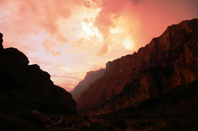
Others may have differing opinions, but this may be my favorite picture from the entire trip.
There are, of course, many Grand Canyons. The one you will see depends on the time of day, the location of the sun and clouds, the presence or absence of storms, and your location, whether deep in the canyon, or somewhere on the rim. It also depends on the rocks you are passing through. I saw a different canyon every day, and almost every hour. It was never boring, not once. Pete, whose raft I traveled in, would probably agree that I spent every moment on the river gazing up at the canyon walls (or transfixed in horror at the lip of big rapids!).
Our fifth day ended at Carbon Creek under gathering clouds. We hadn't experienced any rain since the first day, but storms had always been lurking in the distance. We set up camp and I decided to explore a little bit. I grabbed the camera and a canteen and headed up the gorge behind the camp. The personality of the canyon had changed into one of brooding and gloom. It was partly the clouds, but it was the rocks too. We had reached the Dox Formation, part of the Grand Canyon Supergroup, the billion year old rocks that lay exposed beneath the Tapeats Sandstone.
The Dox is composed of layers of silt, shale and sandstone deposited in a variety of environments, including river floodplains, coast complexes, and deltas. In some places the formation is brightly colored, but here in Carbon Creek on this day, brown and gray seemed to predominate.
I had hoped to go far enough up the canyon to see the Great Unconformity between the Dox and the overlying Tapeats Sandstone, but I found the way to be choked with gigantic boulders that had rolled down the adjacent slopes.
Some of them displayed cavernous weathering, with deep pits and hollows that brought to mind certain horror movies...
 One boulder of Tapeats Sandstone really stood out...it was 15 or 20 feet tall.
People have hiked some distance up the canyon, and have added slabs of rock to produce a makeshift stairway up the layered shale. I worked my way upward.
I would have explored farther up the canyon, but a sudden flash of light and peal of thunder told me that the storm had arrived. I had no rain gear, but I was not overly concerned since I was no more than 200-300 yards from camp. The giant boulders that impeded my progress up the canyon now provided handy shelter from the storm.

The rain came, not in torrents like the first day of our trip, but certainly enough to get wet. I gave some thought to the possibility of a flash flood, and from where I hunkered down, I made sure I had a direct line of escape onto the slopes above.
The thunder crashed and echoed through the canyons. I didn't worry; I had no place I needed to be, so I settled in and enjoyed the experience of a desert rainstorm for the next hour or so. It was even exhilarating, as I recalled the writings of John Muir when he climbed to the top of a pine tree to better observe a wild thunderstorm (I guess we're lucky he survived the experience!).
I had the sense that I wasn't alone. I looked around and realized that two of us were enjoying this storm. The lizard was enjoying it in a different way. He/she was luxuriating in the moisture, just laying there getting wet from head to toe. You can see a little droplet hanging off its tail.
Thomas Moran (1837-1926) was a painter who did much to bring about the existence of our national park system. His dreamlike images of Yellowstone and Grand Canyon popularized both regions, especially two gigantic paintings of the parks that hang in the halls of the Smithsonian. I've always enjoyed his work, even as I recognized the somewhat romanticized views of the scenes that he set on canvas. Such vistas couldn't exist in the real world, of course.
Except that they do. As the storm briefly cleared I realized I was living in a world that had previously existed only in the imagination of the long deceased painter. The clouds opened up holes that briefly let sunlight flash across the cliffs, and in other moments there was only the indirect glow of sunlight reflected off the clouds.
 I took advantage of the lull in the storm and wandered back to camp.
As we ate our dinner the storm returned, and the cliffs across the canyon changed color by the moment, and appeared and disappeared as the squalls moved across our line of sight. The storms continued until the setting sun removed the energy in the air masses, and a few stars began to twinkle in the sky above us. For only the third time in the entire trip I set up my tent, but no more rain fell that night.
Looking at the picture below, the joker in me wants to say "this campsite was just plain rocky", but in reality we were simply drying off the base of the tent prior to packing it up for the day.
 A stream had indeed flowed through Carbon Creek in the night, but it was no flashflood. The water did carve a small channel in the sand near the confluence with the river.
In the morning we saw the one and only scorpion of the trip. I was astounded at the small size. I've seen many of them in my travels, but never one that was barely bigger than a red ant. It was nice of the ant to wander by and provide scale for the picture. They say the smaller ones pack the biggest wallop, but according to the records no one has died in Grand Canyon from getting stung. I wasn't in any mood to experience such a thing, so we let the little guy scurry off under a rock. I shook my shoes every morning after that!