Showing posts with label Marble. Show all posts

Monday, January 15, 2018

A Look Back at Ten Years of Geotripping: I toured a marble quarry on Vancouver Island; It's almost as if they didn't want us to see the rocks.

I've been digging through the archives of Geotripper on the occasion of my tenth anniversary of geoblogging, looking for some of my favorites. In 2015 I spent a lot of time in the Pacific Northwest, resulting in several blog series, but a favorite moment was my tour of this "quarry" which some of you may recognize as something else. This blog appeared on July 13, 2015...

So, I'm out on Vancouver Island, British Columbia, enjoying my vacation with Mrs. Geotripper, and we're casting about trying to figure out what to do on this 300-mile long island. I'm doing some reading and find out that there is this place called the Saanich Peninsula Marble Quarry that offers tours. That sounds great to the geologist in me, so I talk Mrs. Geotripper into checking it out. It turns out that when you are touring an island that is mainly rainforest, rock exposures are in short supply.
I figure that a rock quarry isn't going to have a whole lot of visitors on a given day, so imagine my surprise when we reach the end of the road, and find out that the place has a parking lot, and charges admission! It was pretty steep, too, about $30 Canadian for each of us. But hey, it's rocks, and I haven't seen a lot of rocks on this trip. We pay and go on in. I'm astounded by how many people are here for the tour of the quarry.

I did some research on the rocks. The marble of the Saanich Peninsula is part of the Wrangellia terrane, rocks that formed far out in the Pacific Ocean during the Triassic Period. Around 100 million years ago during the Cretaceous Period the rocks plowed into the west coast of North America and became part of the continent. The rocks were originally limestone that formed in coral reefs and along tropical island beaches. The heat and pressure of the collision with North America caused the rock to recrystallize into marble. Today it is called the Quatsino formation.
So I follow the map, my anticipation rising as we reach the edge of the quarry, and I looked in. I was kind of shocked. There was vegetation everywhere! There was barely any rock to be seen at all! I did notice the smokestack from the smelter almost hidden in the forest beyond the quarry. How could they let this happen? Didn't they care enough to keep the rock exposed for us geologists? 
The hundreds of people around me didn't seem to mind all the vegetation. As far as I could tell, they were actually paying more attention to the flowers and stuff and pretty much ignoring the rock. I was a little confused. But at least the people that run the place have a sense of history. They put up some interpretive signs that showed the raw beauty of the rock before all the vegetation was allowed to grow over it.
The quarry was active from the late 1800s to around 1905 or so. I guess in this temperate rainforest environment the plants can take over pretty quickly. I was kind of surprised by how colorful the flowers and other plants were. I thought that at this latitude, the species diversity was on the low side. I guess not.
I finally found some rock exposures at the lower end of the quarry. The flowers hadn't yet covered everything. Water had filled the lowest part of the quarry, and I guess they were using a fountain to aerate the water or something.
It's almost as if they were ashamed of the rocks. Look at the picture above to see how the plants covered almost every part of the marble. I just didn't get it. In any case, we finished up our tour and found some gelato being sold at a stand in what looked like an old mansion of some sort, so we had a bit of dessert before heading back to Victoria.
So what did I think about the marble quarry tour? I was surprised by how popular and expensive it was, and how easily the visitors were distracted by the vegetation covering all the rocks. The pathways were well done, and there were lots of interpretive signs showing the glory of years past when plants didn't cover every rock, so one got a sense of history, and of loss. On the whole, it wasn't too bad, especially if you like plants and stuff like that. I don't recommend bringing a rock hammer. They got pretty upset when I starting taking rock samples.

If you want to check it out, don't go by the old name of Saanich Peninsula Quarry. They changed it, I guess when it got all overgrown. Nowadays the place is called Butchart Gardens.
The glories of the old days before plants covered everything.

Monday, November 9, 2015

The Karst Topography...of California? California has Natural Bridges, and not Just in Santa Cruz

I've been reviewing some of the stops on our recent field studies course through the karst country of California. This landscape is the portion of the Sierra Nevada Mother Lode that is underlain by the marble of the Calaveras Complex. The marble originally formed as limestone on the floor of the Pacific Ocean, and was mashed into the western edge of North America as the ocean floor was thrust beneath the continent along a subduction zone several hundred million years ago.

The marble was eventually uplifted and exposed at the earth's surface by erosion. The term "karst" refers to the tendency of such landscapes to develop sinkholes as underground caves collapse. Rivers have a tendency to disappear in such places. In today's post, we look at a creek that disappears, and reappears. Twice.
There is a place called "Natural Bridges" that is familiar to many Californians. It along the coast at Santa Cruz, and is actually a sea arch eroded by wave action. Less familiar are the Natural Bridges that span Coyote Creek between Columbia State Historical Park and Vallecitos on Parrot's Ferry Road in the Mother Lode.
In geologic terms, a natural bridge is usually taken to be an arch that has formed as a result of stream erosion. The epitome of such arches are found in Utah at Natural Bridges National Monument in the state of Utah. The bridge at Santa Cruz is more properly termed a "sea arch". Karst processes can also produce bridges, as an erosional remnant left behind as caves collapse, leaving openings through which water is flowing.
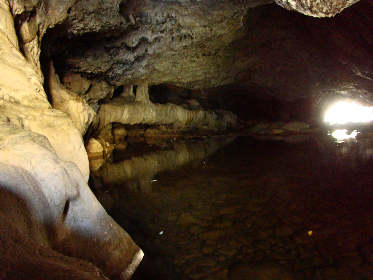
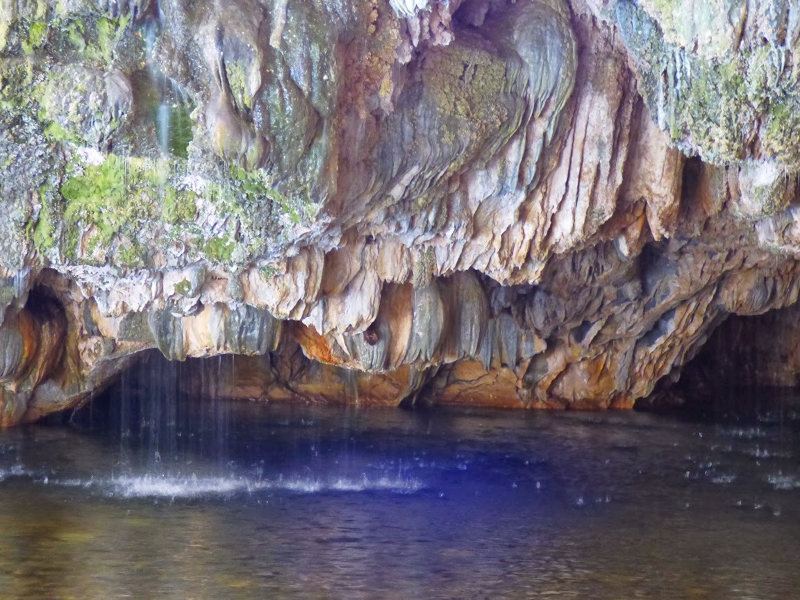
The Natural Bridges of the Mother Lode are certainly karst related, but in a slightly different manner. At Coyote Creek, springs of carbonate-laden water emerged from the hillside above the river, and calcium carbonate, the mineral that makes up limestone and marble, was precipitated into large masses called flowstone (a great deal like Mammoth Springs at Yellowstone National Park). They blocked the creek, but eventually water worked through the base of the spring deposits. Eventually the creek carved a course under limestone dam. The cavern has since been decorated with all manner of speleothems, stalactites, stalagmites, columns, curtains, and others. As can be seen in the pictures above and below, the springs are still active. There is a constant music of dripping water at the entrance to the upper bridge.
You can get a sense of the falling water in the shaky low resolution video below.

There are two bridges on Coyote Creek. Most hikers visit the upper cave, which is at the end of a relatively gentle one mile trail. It takes a bit of scrambling to get to the upper entrance to the cave, but it's apparently a fun float or swim through the several hundred foot long cave. I haven't had the privilege, as I've visted most often during the late fall season when the water has been cold.
It is possible to walk well into the entrances without getting too wet.
The bridges have suffered quite a bit of damage over the years. Tourists have been visiting the site for more than century. A hotel even was constructed on top of the upper bridge for a time. Many of the cave decorations have been broken off. Luckily, floods flush out the cave every so often, and it is high enough that some decorations are out of reach of vandals.
The lower cave lies several hundred yards downstream. Far fewer people know about it, and it is a bit of a challenge to get there. One can follow the creek for the most part, but the way is blocked by brush here and there, so trails of use climb the canyon walls in a few illogical-seeming spots. It's worth the effort, if just to get away from the occasional crowds at the upstream caves.
It's a bit shorter and the downstream exit is visible from the upper entrance (which makes some a challenge of some picture angles).
The bridges are on public lands administered by the Bureau of Reclamation (New Melones Reservoir lies just downstream), so the caves are nominally protected by ranger patrols, though I've never seen one. Mostly those of us who enjoy the caves need to be vigilant for vandals. Check this link for directions and maps to the caves: http://www.usbr.gov/mp/ccao/newmelones/planning_visit.html.
One of the nice things about the walk to the lower cave is the smooth exposures of marble along the creek between the two. It is white marble streaked with gray, and has been polished by numerous floods. The Calaveras marble originated as coral reefs or carbonate muds in tropical environments in the tropical latitudes of the Pacific Ocean. Strangely enough, the marble was featured on the front page of our local newspaper this week. It's about a marble quarry just a few miles away from the bridges. Check it out: http://www.modbee.com/news/article43637292.html.

These rocks have been on an incredible journey.

Friday, November 6, 2015

The Karst Topography...of California? An Exploration of Chaw'se

California can mean a lot of things to people: sunny beaches, snowy ski slopes, glacial canyons like Yosemite, or Redwood forests. But few people ever connect karst landscapes with our fair state. Karst topography? That's a unique terrain that develops when the underlying rock is composed of limestone or marble. It's the kind of landscape one expects to find in Florida, or Kentucky, or Ohio. But not so much in California.

Karst landscapes are influenced mostly the solution of the rock by acidic water, forming underground caverns. Often the caverns are hidden (kind of by definition if you think about it), but sometimes the roof of the cavern will collapse, forming sinkholes. Further erosion of the landscape can produce natural bridges and blind valleys (where rivers and streams disappear underground). Most of California has been too chopped up by faulting to have extensive areas of exposed limestone; it's just not all that common around the state, but it is present in a few places. Death Valley and the Mojave Desert have large exposures of limestone, but the dry climate precludes the formation of many karst features.

On the other hand, marble is found in the western part of the Sierra Nevada, where ancient marine sediments were compressed against the edge of the continent 200 to 300 million years ago. These rocks extend from the Gold Rush town of Columbia in the Mother Lode north past Jackson and Sutter Creek. There are also outliers in Sequoia and Kings Canyon National Parks. And in these rocks, there are caves. Lots and lots of caves! More than 1,000 have been discovered over the years. A few have been developed for tours. Kids in our region often have their first underground experience at Moaning Caverns outside of Columbia, and others have toured Mercer, California, or Black Chasm caves. Crystal Cave has been an important visitor destination at Sequoia National Park for many decades, along with Boyden Cave on the Kings River.
As strange as the rocks look in today's pictures, they are not actually karst features. They're human artifacts, grinding holes used by the Miwok people to crush acorns, one of their most important food sources. Most of the grinding pits in the Sierra are cut into granitic rock, but marble is a bit softer. An unusually large number of them are found in the huge slabs of marble exposed at Chaw'se State Park near the town of Volcano and Pine Grove (the park is sometimes called "Indian Grinding Stone State Park"; I prefer "Chaw'se, which means the same thing).
The holes preserve another unique feature found almost nowhere else: petroglyphs. Petroglyphs are a form of art or communication carved into rock surfaces.There were hundreds of them decorating the grinding holes. They've faded over the years, but some can still be seen. That they are disappearing is a sad consequence of the softness of the rock, and the susceptibility of the rocks to solution by acidic water.
It's not surprising that Chaw'se should be an important cultural center for the Miwok people and other indigenous peoples in the region. There are bark houses and a large roundhouse at the site, and they are occasionally used for ceremonies and celebrations.
The acorns have fed more than just people. A number of animals depend on the oak seed as well, including the comical looking Acorn Woodpeckers, one of which can be seen above.

These pictures are from our field trip last week for our class on the karst topography of the Sierra Nevada. The other highlight of our trip was an exploration of one of the most spectacular caves in the American west. That visit is coming up in a future post.

For more information about the park, check out http://www.chawseassociation.org/index.html and http://www.parks.ca.gov/?page_id=553

Monday, July 13, 2015

I Toured a Marble Quarry on Vancouver Island: It's almost as if they didn't want us to see the rocks

So, I'm out on Vancouver Island, British Columbia, enjoying my vacation with Mrs. Geotripper, and we're casting about trying to figure out what to do on this 300-mile long island. I'm doing some reading and find out that there is this place called the Saanich Peninsula Marble Quarry that offers tours. That sounds great to the geologist in me, so I talk Mrs. Geotripper into checking it out. It turns out that when you are touring an island that is mainly rainforest, rock exposures are in short supply.
I figure that a rock quarry isn't going to have a whole lot of visitors on a given day, so imagine my surprise when we reach the end of the road, and find out that the place has a parking lot, and charges admission! It was pretty steep, too, about $30 Canadian for each of us. But hey, it's rocks, and I haven't seen a lot of rocks on this trip. We pay and go on in. I'm astounded by how many people are here for the tour of the quarry.

I did some research on the rocks. The marble of the Saanich Peninsula is part of the Wrangellia terrane, rocks that formed far out in the Pacific Ocean during the Triassic Period. Around 100 million years ago during the Cretaceous Period the rocks plowed into the west coast of North America and became part of the continent. The rocks were originally limestone that formed in coral reefs and along tropical island beaches. The heat and pressure of the collision with North America caused the rock to recrystallize into marble. Today it is called the Quatsino formation.
So I follow the map, my anticipation rising as we reach the edge of the quarry, and I looked in. I was kind of shocked. There was vegetation everywhere! There was barely any rock to be seen at all! I did notice the smokestack from the smelter almost hidden in the forest beyond the quarry. How could they let this happen? Didn't they care enough to keep the rock exposed for us geologists? 
The hundreds of people around me didn't seem to mind all the vegetation. As far as I could tell, they were actually paying more attention to the flowers and stuff and pretty much ignoring the rock. I was a little confused. But at least the people that run the place have a sense of history. They put up some interpretive signs that showed the raw beauty of the rock before all the vegetation was allowed to grow over it.
The quarry was active from the late 1800s to around 1905 or so. I guess in this temperate rainforest environment the plants can take over pretty quickly. I was kind of surprised by how colorful the flowers and other plants were. I thought that at this latitude, the species diversity was on the low side. I guess not.
I finally found some rock exposures at the lower end of the quarry. The flowers hadn't yet covered everything. Water had filled the lowest part of the quarry, and I guess they were using a fountain to aerate the water or something.
It's almost as if they were ashamed of the rocks. Look at the picture above to see how the plants covered almost every part of the marble. I just didn't get it. In any case, we finished up our tour and found some gelato being sold at a stand in what looked like an old mansion of some sort, so we had a bit of dessert before heading back to Victoria.
So what did I think about the marble quarry tour? I was surprised by how popular and expensive it was, and how easily the visitors were distracted by the vegetation covering all the rocks. The pathways were well done, and there were lots of interpretive signs showing the glory of years past when plants didn't cover every rock, so one got a sense of history, and of loss. On the whole, it wasn't too bad, especially if you like plants and stuff like that. I don't recommend bringing a rock hammer. They got pretty upset when I starting taking rock samples.

If you want to check it out, don't go by the old name of Saanich Peninsula Quarry. They changed it, I guess when it got all overgrown. Nowadays the place is called Butchart Gardens.
The glories of the old days before plants covered everything.

Sunday, October 19, 2014

The Sierra Nevada Underground: How does a newly discovered pristine cave look? Finding out at Black Chasm

There are caves and there are caves. Many of them were discovered long ago, and the easily accessible ones suffered grievous damage. In earlier days, cave decorations (speleothems) were broken off as souvenirs in the sadly mistaken belief that they would grow back quickly. Today's cave vandals have no such excuse. They break and destroy for sheer maliciousness. It's sad either way because caves don't recover, not in any kind of human time-frame. Their special kind of beauty is lost to us.
That's what makes a few caves extra precious. A few weeks ago, I explored Crystal Cave in Sequoia, which by virtue of being in a national park and being discovered by park personnel, was protected before catastrophic damage was done. It was developed for tourism, and millions of people have walked its passageways and yet it was protected by and large from the worst abuses.
The tour I was on yesterday was a different circumstance. Black Chasm cave near the Gold Rush town of Volcano in the Sierra Nevada Mother Lode is a privately owned cavern. It was discovered in the 1800s but the "chasm", a ninety foot deep crevice, prevented the miners from ever getting into the remote reaches of the cave. Access required technical climbing skills, and people who go through that much trouble rarely have vandalism in mind.
A decision was reached in the 1990s to develop the cave for tourism, making a total of six such caves in the Sierra Nevada: Crystal Cave, Boyden Cavern, Mercer Caverns, Moaning Cavern, California Cavern, and Black Chasm. A stairwell and boardwalk were pinned to the edge of the chasm, allowing for access to the nicely decorated room beyond. A room never despoiled by vandals, or dirtied by sooty lanterns and torches.
For those who have only seen the usual soiled yellow-brown stalactites and stalagmites, the pearly white formations are a revelation about what a cave can look like. Beautiful examples festoon the walls. But Black Chasm has an additional feature that is astounding. Stalactites on LSD!
Growing out of the walls at odd angles, and growing in totally random orientations, helictites are strange and rare cave formations. They are easily broken off, and are undoubtedly one of the first formations to disappear from caves. They are present in Black Chasm in, shall we say, large numbers. Really large numbers, enough that the cavern was granted National Natural Landmark status, a federal designation that recognizes the value of natural features on private lands, including agreements to protect the resource.
The exact process by which helictites form is not clearly known. They are most likely related to capillary action of water squeezing out of microscopic openings in small stalactites and precipitating small amounts of calcite. Because water under pressure can be squeezed upwards, the development of the helictites is not governed by gravity.
The number and variety of helictites in the Landmark Room of Black Chasm is simply stunning. I haven't been to every cave in the world, but I would not be surprised if these are some of finest examples in existence (although I am always open to correction on such issues).
Black Chasm Cave, as noted before, is a privately owned business. They are there to make a profit, but they have done a good job of protecting their cave, and I recommend a visit. They offer discounts for educational groups (they can accommodate up to 22 people at a time, so large classes would need to split into two tours). More information about the cave can be found here. Tell them Geotripper sent you!

Monday, December 16, 2013

The Sierra Nevada Underground: Natural Bridges of Gold Rush Country

In our last post we had a look at one of the showcase caves of the Sierra Nevada, Moaning Caverns. They are well-known, if for no reason other than the billboards along Highway 99, and the leaflets in restaurants all over the region. And the cave is spectacular. Far less known are some cavern features just a few miles away as the crow flies: Natural Bridges.

Most people hearing the name will think of Natural Bridges State Park on the beach in Santa Cruz. The caves we visited are a long distance from the coast. They are located on the upper reaches of Coyote Creek, a tributary of the Stanislaus River that drains into New Melones Reservoir near Columbia State Historical Park. It's in the middle of the Mother Lode Gold Rush country.
The bridges are at the end of a hike of about a mile on a good trail, although we were surprised by a bit of mud and snow on the trail last Saturday. It was slippery in a few spots, but we got down the hill okay.
There are two bridges that span Coyote Creek. I thought for a long time that the creek had breached a cavern below the river bed, and that erosion had carved the openings below the bridges. The facts are a bit more complicated. There was a canyon first (no caverns), and a set of springs that emerged from the sides of the canyon. The springs were full of dissolved calcium carbonate, and as the water evaporated, calcite deposits, called travertine, were left behind. They perhaps would have resembled Mammoth Hot Springs in Yellowstone National Park. The springs grew larger and larger, and eventually spanned the creek. Somewhere along the way, the water breached the base of the springs and flowed through, and even eroded into the underlying marble.
The creek usually has a modest flow, although I've read of flash floods that backed up and flowed over the top of the upper bridge. The water has pooled under the bridges, in some places 7-8 feet deep. In warmer weather, visitors will swim or float inner tubes through the caves. Last Saturday, we looked at the snow, and most of us chose to stay dry. It is possible though to explore several yards into the caves on dry rock.
The lower entrance to the main bridge/cave is wide with a large clear pool of water. In the afternoon, the sun reflects off the surface and shimmers on the roof of the cave.
Some of the springs that formed the travertine are still active, and pour into the pool from the ceiling of the cave entrance. There is a constant chorus of dripping and pouring water.
After exploring the upper cave, we made the somewhat more complicated trip downstream to see the lower bridge. There is a trail, but it climbs the south slope in a few seemingly illogical spots (although trying to bushwhack through the "shortcut" soon convinced us otherwise).
Around a third of a mile downstream, the lower bridge comes into view. Like the upper bridge, the water has ponded inside, requiring a swim or float to get through. There are rock ledges that provide dry access for some distance into the upper entrance.
Both of the caves show the effects of decades of visitation and occasional examples of wanton vandalism, but plenty of features remain, especially those that are out of reach in the darkness above. Since the construction of New Melones Reservoir, the caves fall under the jurisdiction of the Bureau of Reclamation, so the caves have some degree of protection, and the area was free of trash and garbage when we visited.
Maps and description of the trail can be found at http://www.usbr.gov/mp/ccao/newmelones/planning_visit.html#hiking. Parking is provided along an older route of Parrots Ferry Road a few miles north of the Gold Rush town of Columbia. It can also be accessed from Vallecito on Highway 4. There is a vault toilet at the trailhead, but not along the creek. The trail is particularly beautiful in the spring when the wildflowers bloom.