Showing posts with label Columbia State Historical Park. Show all posts

Monday, November 9, 2015

The Karst Topography...of California? California has Natural Bridges, and not Just in Santa Cruz

I've been reviewing some of the stops on our recent field studies course through the karst country of California. This landscape is the portion of the Sierra Nevada Mother Lode that is underlain by the marble of the Calaveras Complex. The marble originally formed as limestone on the floor of the Pacific Ocean, and was mashed into the western edge of North America as the ocean floor was thrust beneath the continent along a subduction zone several hundred million years ago.

The marble was eventually uplifted and exposed at the earth's surface by erosion. The term "karst" refers to the tendency of such landscapes to develop sinkholes as underground caves collapse. Rivers have a tendency to disappear in such places. In today's post, we look at a creek that disappears, and reappears. Twice.
There is a place called "Natural Bridges" that is familiar to many Californians. It along the coast at Santa Cruz, and is actually a sea arch eroded by wave action. Less familiar are the Natural Bridges that span Coyote Creek between Columbia State Historical Park and Vallecitos on Parrot's Ferry Road in the Mother Lode.
In geologic terms, a natural bridge is usually taken to be an arch that has formed as a result of stream erosion. The epitome of such arches are found in Utah at Natural Bridges National Monument in the state of Utah. The bridge at Santa Cruz is more properly termed a "sea arch". Karst processes can also produce bridges, as an erosional remnant left behind as caves collapse, leaving openings through which water is flowing.
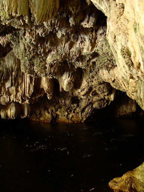
The Natural Bridges of the Mother Lode are certainly karst related, but in a slightly different manner. At Coyote Creek, springs of carbonate-laden water emerged from the hillside above the river, and calcium carbonate, the mineral that makes up limestone and marble, was precipitated into large masses called flowstone (a great deal like Mammoth Springs at Yellowstone National Park). They blocked the creek, but eventually water worked through the base of the spring deposits. Eventually the creek carved a course under limestone dam. The cavern has since been decorated with all manner of speleothems, stalactites, stalagmites, columns, curtains, and others. As can be seen in the pictures above and below, the springs are still active. There is a constant music of dripping water at the entrance to the upper bridge.
You can get a sense of the falling water in the shaky low resolution video below.

There are two bridges on Coyote Creek. Most hikers visit the upper cave, which is at the end of a relatively gentle one mile trail. It takes a bit of scrambling to get to the upper entrance to the cave, but it's apparently a fun float or swim through the several hundred foot long cave. I haven't had the privilege, as I've visted most often during the late fall season when the water has been cold.
It is possible to walk well into the entrances without getting too wet.
The bridges have suffered quite a bit of damage over the years. Tourists have been visiting the site for more than century. A hotel even was constructed on top of the upper bridge for a time. Many of the cave decorations have been broken off. Luckily, floods flush out the cave every so often, and it is high enough that some decorations are out of reach of vandals.
The lower cave lies several hundred yards downstream. Far fewer people know about it, and it is a bit of a challenge to get there. One can follow the creek for the most part, but the way is blocked by brush here and there, so trails of use climb the canyon walls in a few illogical-seeming spots. It's worth the effort, if just to get away from the occasional crowds at the upstream caves.
It's a bit shorter and the downstream exit is visible from the upper entrance (which makes some a challenge of some picture angles).
The bridges are on public lands administered by the Bureau of Reclamation (New Melones Reservoir lies just downstream), so the caves are nominally protected by ranger patrols, though I've never seen one. Mostly those of us who enjoy the caves need to be vigilant for vandals. Check this link for directions and maps to the caves: http://www.usbr.gov/mp/ccao/newmelones/planning_visit.html.
One of the nice things about the walk to the lower cave is the smooth exposures of marble along the creek between the two. It is white marble streaked with gray, and has been polished by numerous floods. The Calaveras marble originated as coral reefs or carbonate muds in tropical environments in the tropical latitudes of the Pacific Ocean. Strangely enough, the marble was featured on the front page of our local newspaper this week. It's about a marble quarry just a few miles away from the bridges. Check it out: http://www.modbee.com/news/article43637292.html.

These rocks have been on an incredible journey.

Saturday, November 7, 2015

The Karst Topography...of California? Getting Filthy Rich from Karst in Columbia

The Fricot Nugget at the State Mineral Museum in Mariposa, California
As I noted in the last post, California has some unique landscapes that are unfamiliar to most visitors, specifically karst topography. Karst results when a region is underlain by limestone or marble. The formation of caves is sometimes revealed at the surface when the roof of a cavern collapses, forming sinkholes and related features. At Chaw'se in the last post, we saw how karst topography was utilized by the Miwok people. Today we look at how another culture used karst, and in the process nearly brought about the end of the Miwok and other native peoples in California. It was all about gold.
The southern Mother Lode in the vicinity of Columbia and Sonora.

The western part of the Sierra Nevada is composed not of granite, but of metamorphic rock like slate, marble and metavolcanic greenstone. The metamorphic rocks contained widely disseminated bits of gold, but hydrothermal activity related to the intrusion of granite in Mesozoic time concentrated the gold into veins of quartz and other minerals. The veins came to be known as the Mother Lode, and they were the source of riches and misery. In most cases the miners were after gold-bearing river gravels along rivers that flowed through the Mother Lode, or they developed mines that cut directly into the quartz veins. When the easy gold was gone from the rivers, they expanded their search into unexpected areas. One of those places was the ancient riverbeds of another era, long before the present day Sierra Nevada existed.
Fifty million years ago, the Sierra Nevada didn't not exist as a mountain range. There were the eroded remnants of an ancestral Sierra Nevada that developed during the late Paleozoic and early Mesozoic eras when masses of land slowly mashed into the western edge of North America, and when subduction zones produced magma that eventually became the granite of the high Sierra. Those mountains were gone, and instead there were slow-flowing rivers that had their origin in what is today central Nevada, with hints of headwaters much farther away, perhaps even Canada. The rivers flowed into a coastal complex that was characterized by swamps, jungles, and sandy beaches. These ancient rivers were ultimately diverted here and there by lava flows, which forced the water into new channels that became today's rivers, like the Stanislaus and Tuolumne. The ancient river gravels that remained were perched on high flat ground between today's river canyons. The gravels often contained gold, but something very odd happened at the site of Columbia State Historical Park. It involved karst topography.
The rocks near Columbia form a landscape unlike those found anywhere else in the Mother Lode, or anywhere in California for that matter. The limestone that formed in Paleozoic oceans 300 million years ago was recrystallized by heat and pressure into marble. Groundwater moved through cracks and fissures in the marble, widening the fissures, and in some cases forming caverns. A channel of the ancient rivers flowed over the roughened surface, and the fissures captured stunning amounts of gold. Eventually the rocks lay covered by two or three meters of soil and gravel. Until the miners found the gold...
The gold deposits at Columbia were unbelievably rich. According to some estimates by geologists of the California Geological Survey, some 4 million ounces of gold, worth about four billion dollars at today's prices was mined here. The entire production of gold in California over the last 150 years amounted to about 110 million ounces, so this one mining area produced a significant percentage of all the gold mined in California.
This gives us an explanation for the strange landscape around Columbia. The miners had very little water from local sources, so flumes and penstocks were constructed to bring water from higher parts of the Sierra Nevada. Instead of using sluice boxes or pans, the miners shot water cannons at the soils, moving vast amounts of sediment and quickly exposing the gold (this was called hydraulic mining). Parts of the town were built on gold-bearing soils, and there was the occasional suspicious fire that destroyed buildings, allowing the miners to blast away a bit more ground. What they left behind was a kid's wonderland of boulders, fissures, and small caves that is every bit as fun as Tom Sawyer Island at Disneyland (I'm disappointed that I didn't grow up as a kid around here. I had to settle for Tom Sawyer Island at Disneyland...).

It's probably no surprise to realize that the Gold Rush was a disaster for the native cultures in California. The indigenous people already been decimated by European diseases and unfortunately some of them lived in gold country. They never had a chance against the influx of tens of thousands of miners from all over the world. Some tribes disappeared entirely, and others barely hung on to their lives and culture.
Columbia hung on as a town after the gold deposits gave out, although the downtown area fell into disuse. In the 1930s, efforts began to make the area a state park, and in 1945 the town center was established as Columbia State Historical Park. The stores and restaurants were refurbished and visitors are treated to park employees and business owners in period dress. And a dandy candy store that is often the only business still open when our students arrive in town at the end of our field trip.

Wednesday, November 4, 2009

Getting hosed in the Mother Lode: Columbia


A recent post included a description of the hydraulic mining that took place in the Sierra Nevada Mother Lode here in California. We visited some of these sites on our recent field studies exploration of the gold mining region. The last stop of the day was at Columbia Historical State Park, where in the last rays of the setting sun we took in one of the more unusual "ghost" towns of the Mother Lode.

First off, it is not really a ghost town, as several thousand people live in the area, and the region supports a community college that is part of our district. It is, on the other hand, one of the best preserved towns of the Gold Rush era. After it burned down a few times early on, the inhabitants caught on that brick might be a better construction material than wood, and so a rather large selection of 1800's vintage buildings survive. Museums, stores, and restaurants, even an old-time theatre are available for tourists.

For we geologists, and for children (is there a difference?), the town has a special treat: big rocks! What's the story here?

In Paleogene time (I still like saying "Tertiary time"), the Sierra Nevada was a vastly different place. The mountains were lower, and large rivers traversed the landscape in shallow valleys. Flowing across the Mother Lode quartz veins, the rivers picked large amounts of gold, and carried it downstream. A particular channel, the Tertiary Calaveras River, flowed across an exposure of marble, part of a metamorphic exotic terrane called the Calaveras Complex.

Marble, like limestone, is composed of calcium carbonate and is easily dissolved by slightly acidic water. Over the millennia, caves developed underground, and the surface was punctuated by sinkholes and blind valleys, features typical of karst topography. The surface rocks were extremely uneven with deep crevasses and cracks. The rough surfaces acted like riffles where the river passed over, trapping vast amounts of placer gold.

Much of the surface around Columbia and nearby Rawhide Flat is composed of these unusual looking rocks, pictured above. But Columbia itself sits atop a flat shelf around 15 to 20 feet higher than the bouldery surface. Why?

It turns out that the town sits on a section of the original soil surface that existed before the hydraulic miners attacked the rocks in the area. Before the miners arrived, the boulder outcrops were not visible, as they were buried in clays, soil and river deposits. Once the miners figured out that huge amounts of placer gold occupied the cracks and fissures, they pursued the riches with wild abandon, spraying away the soil and sediment, ultimately recovering between 3 and 4 million ounces of gold (think $3 to $4 billion at today's gold prices!). It has been called one of the richest single placer deposits in the entire world.

The miners worked their way right up to the very edge of town, and I have heard that occasionally buildings would burn down under suspicious circumstances. Instead of rebuilding, the site was mined instead.

The town is a pleasant place to visit, and the Candy Shop comes highly recommended. Be aware that because of the California state budget mess, parts of the park are shut down to save some piddling amount of money for the state. For instance, a number of the park bathrooms are locked up. I don't know the present status of the museum.