Showing posts with label Lehman Caves. Show all posts

Monday, January 21, 2013

Leaving the Abandoned Lands for Greener Pastures: Wrapping up a Tour of the Colorado Plateau

We'd been on the road for a while, back in June of 2012. Our tour of the Abandoned Lands had taken us on a grand loop that included Grand Canyon, Petrified Forest, the pueblos of New Mexico, the Jemez Caldera, Chaco Canyon, Mesa Verde, Arches, Canyonlands, and Bryce Canyon National Park. 35 of us had been living as a slightly dysfunctional family for the last 15 days, with all the excitement and frustration that such expeditions entail. We were now leaving the Colorado Plateau and making a three day journey home through a part of the country that has been, if anything, even more abandoned than the Plateau: the Basin and Range Province.

After our day of exploring Bryce Canyon, we moved down the highway to Zion National Park for our last evening in Utah. In the morning, we learned about some of the spectacular geology of the wonderful park, and our students were given several hours of free time to hike in the upper canyon. I'd like to show you an entire album of beautiful pictures of one of our most beautiful national parks, but to tell the unvarnished truth...I was tired and worn out! I had explored Zion four weeks earlier, and on this particular morning, I really wanted a...normal breakfast. Mrs. Geotripper and I went down to Springdale, and while the others were struggling up Angel's Landing, or slogging up the river in the Virgin Narrows, we sat sipping mocha and luxuriating our way through a couple of delicious breaksfast burritos at the Cafe Soleil. We were also doing something that had been well nigh impossible for most of the last two weeks: we went online. I even managed a short post that day.
Things were going well enough, and we were just a bit behind schedule after visiting the very cool Dinosaur Trackway museum in St. George. Then things kind of fell apart...

2012 had been a horrific drought year, and for much of our trip, brushfires had been a companion, either in plain sight on the distant hills, or far beyond the horizon. On this day, the fires were a lot closer. It was burning next to I-15 between St. George and Cedar City. And it brought traffic to a dead standstill in the 105 degree heat. Ultimately one of our vans stalled (the food van!), and one of our party ended up in the emergency room with smoke inhalation problems. We were three hours away from our destination and the sun was setting. Ultimately, we left the van and several of our party in Cedar City for the night, and the rest of us headed to Great Basin National Park, arriving at our campsite around midnight.
A new sunrise is a wonderful thing, bringing as it does the promise of a different day. We were in Great Basin National Park, a park with no basin, but with lots of other neat things. The park was established in 1986 to preserve a representative part of the Basin and Range province. It includes Nevada's highest entire mountain (sure, Boundary Peak is a bit higher, but it's mostly in California), a forest that included the oldest living thing on the planet (a bristlecone pine), Nevada's only glacier, and a marvelous limestone cavern: Lehman Cave.
We took the tour of the cavern, which is in good shape for a cave that has been known and explored for more than a century. Some areas were damaged by the early visitors, but most rooms are decorated with a fine variety of speleothems (an overall term for stalactites, stalagmites, columns and all the other features found in caverns).
Those who vandalize caverns usually concentrate on stalactites and soda straws, the speleothems which hang from the ceiling of the cave. Stalagmites, which grow from the floor upwards are sometimes passed over in the less visited caves by souvenir hunters. There are some fine ones in the depths of Lehman (below).
Columns are harder to break apart, and don't look as "cool" in a cave vandal's collection. Some fantastic columns remain in pristine condition at Lehman Cave. Don't get me wrong...people who vandalize and steal from caves are criminals, plain and simple. It's just that in the earlier days, tourists were encouraged to collect a souvenir of their trip. There were so many stalactites in newly discovered caves that it hardly seemed to hurt anything to break off a few. Until they were gone, that is, and a great many holes exist today that were once beautiful caverns in the past.
Lehman Cave is especially noted for the number (300+) of shields. The origin of these disc-shaped speleothems is somewhat enigmatic, and they are not present in most caves. Shields actually usually include two shields with a flat open surface between them (kind of like cymbals).
After our tour, we set out across the Great Basin, on America's so-called "Loneliest Highway". We detoured briefly to look for garnets at the imaginatively named Garnet Hill near Ely, Nevada. We spent a night at Berlin-Ichthyosaur State Park outside of Gabbs, Nevada, and the next day we were home, via Mono Lake and Tioga Pass in Yosemite National Park (see here for a description of the sights along that highway; we passed this way in 2011 and I wrote all about it).
And so it was that we too abandoned the Abandoned Lands, but not without developing an understanding of the why the land drew people, and why they left it. There are plenty of lessons for us today in this country, both in the 2 billion year geological history, and in the 12,000 year human history. People inhabit this landscape today, but most can only do so because of the importation of food and energy from elsewhere. What happens when the fuel runs short?  What happens when the years-long drought becomes a decades-long drought? What happens when the water, especially in the Colorado River, is down to a relative trickle? It's beyond ironic that the most precious resource in this arid land is the most important export, slaking the thirst of cities like Las Vegas and Los Angeles and the farms of the Imperial Valley of California. So many questions...

I hope you've enjoyed this blog series! I'll be trying to get all the posts compiled in one place if you are at all interested in catching the flow of the journey.

Thursday, August 18, 2011

Vagabonding across the 39th Parallel: A Park without its Namesake, and an "Oh, s**t" moment in Science

What is it that this park is missing?
Our next destination, as we went vagabonding across the 39th parallel, was one of our country's more unusual national parks. Unusual? We have lots of unusual national parks; they preserve unique natural and historical landmarks all over the place. But what about a park that doesn't preserve what it is named after? A park that sort of won a lottery to get chosen as a park in the first place? Great Basin National Park has an unusual history. Click on the picture above, and the one below (click a second time to magnify the panorama) to get a sweeping view of one of our newer national parks.
The answer is in this picture somewhere...
My first paragraph is not meant to disparage the park; it is actually one of my favorites, and the park and I go back pretty far in time. I visited the area in 1984, two years before the national park designation was passed by Congress and affirmed by Ronald Reagan (that by itself is a surprise). I've been back 15 or 20 times since then. It has some things that many other national parks lack: solitude and crystal-clear skies. The number of visitors at Yosemite Valley during just three days this last June equals the number of visitors in an entire year at Great Basin. At the beginning, there were more cows in the park on a daily basis than people (that aspect has thankfully changed, however). The park has some intense geology, too.

The centerpiece of the park, and the destination for the vast majority of visitors is Lehman Cave. I discussed Lehman a few weeks back, and the self-imposed rules of our trip required us to do different things than normal. One choice would have been to explore one of the other 25 caves in the park but we definitely were not prepared for such an undertaking. There is also a spectacular limestone arch in the southern part of the park, but we just didn't have the time this trip. We headed up to the end of the road beneath the cliffs of Wheeler Peak.

On the way up, we had a marvelous view of the northern part of the Snake Range and Mt. Moriah (12,072 feet). An impressive detachment fault system is exposed on the flanks of the mountain, and is the destination for numerous geology field camp mapping expeditions.
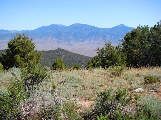
Mt. Moriah and the Northern Snake Range
There were numerous prickly pear cacti growing along the roadside. The ecosystem of Great Basin National Park is changing. For more than a century, cattle grazing took place within the area that would become the park. The political compromise that led to the formation of the park included a provision that grazing would continue unimpeded, but eventually an agreement was reached with the grazing leaseholders that removed cows from the park (and gave the ranchers allotments elsewhere). This was a nice change. The first few years, camping was smelly, and one had watch where one stepped.

The removal of cows from the park has meant that riparian habitats have begun to recover, and the vegetation cover on the mountain slopes has been changing. Eventually, the deer, and perhaps bighorn and elk, will become the dominant grazers. I don't know how the cacti will do; they usually thrive in cow landscapes, but I don't know if they compete well in other situations. They sure are pretty when they are blooming!
Prickly Pear Cactus
Great Basin has a diverse collection of trees, including spruce, fir and ponderosa that indicate connections with the Rocky Mountains. The Great Basin has other trees that are more characteristic, such as Pinyon Pine, Utah Juniper, and a personal favorite, Mountain Mahogany. Mahogany is barely a tree, really, more like a very woody and tall shrub. But when I am high on a mountainside in the Great Basin, the odor of the mahogany is distinctive, and invariably brings back pleasant memories.
Mountain Mahogany
The road ends at a small campground and trailhead at about 10,000 feet. We wandered along the nature trail beneath the high glaciated limestone cliffs and enjoyed the late spring. Snowbanks were still melting and little rivulets were flowing everywhere.
Wheeler Peak (13,063 feet) is the second highest peak in Nevada. Unlike Boundary Peak, which I discussed in the last post, Wheeler is entirely within Nevada, and it is a dominating presence in the region. I think Nevada should just trade Boundary Peak to California for another casino somewhere and celebrate Wheeler as their distinctive mountain. It has a lot of geological personality.
Wheeler Peak
There was a beautiful collection of Shooting Stars in the meadow along the trail...
Shooting Star
We started back down the road, and stopped for a moment at Mather Overlook, at just over 9,000 feet. Mather provides a wonderful perspective of the cirque containing Nevada's only glacier/rock glacier/permanent ice field, depending on how you want to define such things.
Wheeler Peak from Mather Overlook
The glacier, the cave, the prominent peak, the arch, they all add up to a unique park that nicely represents Nevada's Basin and Range Province. The only thing it seems to lack one thing: a basin. Why call it Great Basin National Park, if it doesn't have a basin? The answer is mildly convoluted, so bear with me.

First of all, the "Great Basin" refers to the hydrologic province that covers practically all of Nevada, in which no water flows into the Pacific Ocean. The water from the three hundred or so mountain ranges in the state flows into the adjacent basins and either sinks into the ground or evaporates. There is no "great basin" as such; Nevada is probably the most mountainous state in the union. The Basin and Range Province covers some of the same territory, but is a much larger landscape that spills over into Utah and Arizona.

There was a movement decades ago to designate a park that could represent Nevada's unique landscape. Death Valley National Monument (a monument at the time; today it is a national park) preserved the driest and lowest parts of the province, but Death Valley is in California, and one could not mistake the barren peaks and valleys as being similar to the typical mountains of Nevada. At first, they couldn't quite decide which mountain range should be preserved. As I understand it, three ranges were finalists: the Toiyabe Range near Austin, the Ruby-East Humbold Range near Wells, and the Snake Range, which was eventually chosen. I think any of these would have been a great choice, and I would even ask: Why not all three?

The Ruby-East Humboldt is a high glaciated range with some lakes, and a wildlife refuge on the adjacent lake on the valley floor. The Toiyabes are more typical of the Basin and Range, in that while very high, there was little in the way of glaciation, and little connection with the Rocky Mountains or Sierra; the forests are primarily pinyon, juniper and mahogany. Both of these mountains are rugged and beautiful. But the Snake Range won out in the end, perhaps because the National Park Service already had a presence with Lehman Cave National Monument.

But the new park ended up not having a 'basin' in it. An appropriate park designation would have included the adjacent valley floors and even another mountain range (the Schell Creek range, perhaps) to preserve a complete example of the province. The central focus of Death Valley, for instance, is the valley floor. The original boundaries were much larger, in fact. Because of political realities (an anti-environment president was in office, and the "Sagebrush Rebellion" was in full swing), the proposed boundaries shrank until they were palatable to the Republican legislators (the compromise included the grazing exception as well). Wouldn't it have been nice to see what at least one major valley in Nevada looked like without cattle grazing? Imagine, for instance, what other animals visitors could enjoy. The valley floor would also preserve more cultural features. The remains of the westernmost known Fremont Culture village is found close to Great Basin National Park (the Baker Archaeological Site).
Why isn't this valley part of Great Basin National Park?
We were done with our exploration of Great Basin, and we set out on Utah 21 to Milford. In a matter of minutes, we could see a herd of non-cow animals in the distance. We stopped and pulled out the zoom lens. They were pronghorns!
It would be so nice if this were part of Great Basin National Park. There is value in the barren arid landscape, too. It's part of the complete ecosystem that makes up the Basin and Range Province, and a portion should be preserved.
Picture by Mrs. Geotripper
Oh yeah...my title alluded to an "Oh s**t moment in science (I'm still striving, hard, to keep my blog family friendly, but the word is so appropriate here). Another wonderful and distinctive aspect to Great Basin National Park are the Bristlecone Pines. These trees cling to life on the highest slopes of Wheeler Peak and other mountains in Basin and Range. They are small trees, and live up here because they can't compete well in lower, warmer climates. But if you want to talk about persistence and tenacity, these trees stand alone. They can live for thousands of years, and a tree in the White Mountains of California has survived for 4,700 years, the oldest non-clonal life form on the planet.

The bad moment? Back in the 1960's Donald Curry (a graduate student who went on to a very distinguished academic career) was working on efforts at tree-ring dating and determining the timing of the "Little Ice Age". He was coring bristlecones in what would later become Great Basin National Park. His coring tool broke, and he asked permission to cut down the tree to retrieve the data from the tree rings. The forest service decided the tree was not significant and gave him permission to do so. They cut down the tree, and analyzed the rings. To their abject horror, they discovered they had just killed the oldest living organism on the planet, perhaps several hundred years older than the Methuselah Tree in the White Mountains.

What a thing to be remembered for. To his credit, Curry advocated for the establishment of Great Basin National Park.
A bristlecone snag in the White Mountains. Even after death, the wood may resist decay for thousands of years.
Another geoblogger who spends time at Great Basin National Park is Silver Fox over at Looking for Detachment. Check out some of her posts; there's some excellent writing there...

Sunday, August 7, 2011

A Convergence of Wonders, Day 15: We Head Underground in the Great Basin

It was Day 15 of our Convergence of Wonders journey in the Pacific Northwest and Northern Rocky Mountains (June 29th). Being only a day from home, we had actually left the PNW and Rockies far behind, and we would be traveling upwards of 500 miles on this day to get as close to home as was practical. We were crossing the vast, mostly barren expanse of the Basin and Range Province in western Utah and eastern Nevada on America's "Loneliest Highway".

People may be forgiven for thinking that "lonely" equates to "uninteresting". I know differently, having gone to college in Reno, and doing some extensive geo-touring across the region. Silver Fox, over at Looking For Detachment, understands this as well, and is a great resource for understanding some of the incredible geology to be found in this unique landscape. Unfortunately, it had been two weeks of hard traveling, and it was getting harder to rouse the troops! But two stops caught everyone's attention.
We drove the two hours from Topaz Mountain to Great Basin National Park near Ely, Nevada. We found a nice spot under a huge cottonwood tree at the visitor center to talk about the park's geology. It's rich, and I will have more to say about it in the future. But the park's centerpiece is Lehman Cave, and we were going on a tour.
Of course, we needed a guide, and we heard the usual thing one always hears: "Don't Touch Anything!" Of course, such admonitions are necessary, as caverns are one of the most fragile environments to be found anywhere. A single broken stalactite will take centuries to grow back, if ever (many caverns are not active...few parts of Lehman Cave have any water at all). In the earliest days, cavern explorers took a stalactite as a souvenir. More than a million people have now toured the cave...how would the cave look if even a fraction of that many people broke something off and absconded with it?
Luckily many of the cavern's decorations, called speleothems, are still intact. There are rich examples of dripstone speleothems, like the familiar stalactites, stalagmites, and columns. Photographing caves and cave features is always a challenge for me. Flash can be used, but such pictures are often washed out and have little depth. I try to use the provided light when I can (I almost wrote "natural light", but that would be silly to say). Tripods aren't allowed on the tours, so I braced the camera on the railing for the pathway, and used a 2 second delay on the shutter so the pushing of the shutter release wouldn't shake the camera.
 Here are lots of the familiar dripstone features...
Lehman Cave is unique for the 300 or so cave shields that are found within. They are only found in about 80 other caves around the country (out of thousands). The shields can be thought of as two fossilized cymbals, two large disks separated by a thin crack. Their origin is not well understood.
 There's another shield in the little alcove below...
 And a pair of shields in a solution tube...
The cave is well worth the long journey. And there are many other features that make Great Basin a unique destination. Unfortunately, the tour ended, and we were in a hurry to get across the desert.
We made a brief stop at the Baker Archaeological Site, a village on the desert floor that is the westernmost Fremont Culture site so far discovered. The site itself is unremarkable to see (it was excavated years ago and no artifacts are displayed), but the view of the Snake Range and Great Basin National Park is spectacular.
We made a gasoline stop in Ely, the metropolis of eastern Nevada (around 4,000 people), and headed up the hill near Ruth, Nevada to search for some more gemstones. This time our target was the garnet crystals of Garnet Hill. Most geologists probably associate garnet with metamorphic rocks, but on Garnet Hill, the gems are found in a rhyolite intrusion/caldera complex that is very similar to the rocks that hosted the topaz crystals that we found in Utah the previous day. The federal Bureau of Land Management set aside the site from mineral claims to keep it accessible to casual collectors like ourselves. It's at the end of a three mile dirt road which is usually passable for passenger cars.

There were different strategies for finding deep red garnet crystals...one could pound rocks open with a rock hammer, and use a lot of calories and sweat, or one could let the car traffic do the work for us. There are enough crystals that car tires break the gems out and they can be discovered by simply walking along the road watching for dark spots.
The crystals display very nice faces. They look black, but if you look closely (click on the photos), you can make out the rich deep red color (this variety is called almandine garnet).
These specimens are pretty small, less than a quarter of an inch, but I have seen some found here nearly an inch across.
It was getting on towards 3 o'clock, and we still had something like 250 miles to go, and it was going to be sundown when we arrived at camp, if everything went right. Everything didn't...

It wasn't our accident, but some motorcyclists lost control in the heavy winds that were buffeting the highway and crashed, and we had to wait for ambulances to come and clear the scene. Apparently no one was dead, but the traffic was blocked in both directions for well over an hour, so we were suddenly grievously behind schedule
Instead of waiting until late in the evening for dinner, we stopped in Eureka and invaded their few restaurants. 180 miles to go, and the sun was hitting the horizon. There were storms all around us, and the skies were glorious. The sunset was one of the more beautiful ones we saw this trip, but we couldn't stop for pictures.
We rolled into camp at Berlin-Ichthyosaur State Park just before 11 o'clock and set up camp for the last time. Tomorrow we were going home. And yet still more treasures lay ahead on the road. That will be the subject of the next and final post of this series!
The sunset and storm pictures are courtesy of Mrs. Geotripper.