Showing posts with label Coast Ranges. Show all posts

Tuesday, January 16, 2018

A Look Back at Ten Years of Geotripping: Driving Through the Most Dangerous Plate Boundary in the World

Driving through the most dangerous (kind of) plate boundary in the world is actually not very easy to do. Subduction zones, with the exception of the volcanoes, are mostly deep under the sea. But Central California is a unique case, being an ancient subduction zone that has been uplifted and exposed by erosion, so that interested parties can literally drive through what once was miles underground or at the bottom of the deepest oceans. I got the idea for this blog series when I spent an afternoon driving the winding road that travels over the Coast Ranges at Lick Observatory, and down through Del Puerto Canyon into the Great Valley. It's the equivalent of driving twenty or thirty miles into the Earth's crust. Looking back over the titles, I'm worried that I am using up my lifetime supply of bad jokes...

I've been reviewing the archives this week to find some of my favorite posts from ten years of geoblogging. This compilation appeared on July 4, 2015.

Without a doubt, subduction zones are the most dangerous plate boundaries on the planet. Divergent plate boundaries produce earthquakes and occasional volcanoes, but nothing on the fearsome scale of the calderas and stratovolcanoes and magnitude 9 earthquakes experienced at convergent boundaries. Transform boundaries produce earthquakes, but they are magnitudes smaller than those produced at convergent boundaries (despite what certain Hollywood movies have asserted recently). Hot spots, while not a plate boundary, can produce huge caldera complexes like Yellowstone, but such monsters have not had much of an effect on human history of the last few thousand years. It is the subduction zones of our planet that have caused the most human misery, in the form of massive earthquakes, tsunamis, and violent volcanic eruptions.
We have been driving through an example of one of the most dangerous plate boundaries in the world, but our particular example has been inactive for a very long time. Central California was a subduction zone complex for more than 150 million years, primarily during the Mesozoic era, but it changed into a transform boundary only a few tens of millions of years ago. The San Andreas fault is the resulting feature, and it is capable producing damaging earthquakes, but even the most destructive quakes, like 1906 in San Francisco (death toll 3,000), is but 1/30 of the energy of a magnitude 9 quake like that of Indonesia in 2004 (where the resulting tsunami killed 200,000 people).

It's taken a couple of months to work through our journey, so I've compiled all of the posts here so one can catch the continuity of the story. Here goes...

A New Blog Series
The introduction to the new series, a geological transect from the California Coast to Yosemite Valley, crossing an ancestral subduction zone that once caused geological havoc in a zone from Mexico to Canada (and still is in a few places).

Reconnaissance

An overview (in the most literal sense) of the lands we will traverse on our journey. We have a look at central California from above.

These Rocks are All Wrong!
Granite is exposed in the rocks of the Point Reyes Peninsula. But the arrangement of rock and sediment in subduction zones suggests that granite shouldn't be anywhere near here. It's the San Andreas fault. In California, it's always the San Andreas' fault.

Looking for the Big One
The peace and serenity of Tomales Bay belies a violent past. The San Andreas fault slices right through the bay, and produces large earthquakes with disturbing irregularity. The epicenter of the San Francisco quake in 1906 was not far from here.

Welcome to Geology's Junk Drawer
The Marin Headlands began as a giant collector of geological flotsam and jetsam from the crust of the Pacific Ocean. The jumble of rocks accumulated in an accretionary wedge, and were later lifted up into the mountains of the Marin Peninsula.

Geology's Junk Drawer on the Marin Headlands
Exploring the hidden corners of the Marin Headlands, we find Redwood forests, beautiful views of San Francisco, and disturbing reminders of World War II.

Terra Fatale on the Marin Headlands
Although the subduction zone that formed the rocks of the Marin has been extinct for a long time, there are still plenty of hazards remaining in the region, both geological and nautical. The Point Bonita Lighthouse has been present in one form or another for 160 years. It hasn't always worked, as there are upwards of 300 shipwrecks in the area. There are other hazards too.

The Alien Bursts Forth in the Diablo Range!
We head across San Francisco Bay and start an arduous journey through the Diablo Range. The range formed as an exotic (read "alien") terrane pushed upwards through the sediments of the Great Valley Group, piercing the surface and rising into the sky. John Hurt would no doubt approve...

Exploring the Belly of the Beast in the Diablo Range
We make the first part of a long drive through a rugged portion of the Diablo Range, one of the largest sub-ranges in the Coast Ranges of California. Along the way we cross through two exotic terranes of rocks that had been carried miles deep into the crust in the accretionary wedge of the subduction zone.

At the Portal of Hell in Diablo Range
Making our way down Del Puerto Canyon in the Diablo Range, we do the equivalent of traveling through the crust of the Earth all the way into the mantle, finding outcrops of peridotite and dunite, rocks containing the mineral olivine among others. For the mercury miners, this truly was a portal to Hell.

Exploring the Ocean Crust without Unobtanium
Del Puerto Canyon cuts a swath through the Coast Range Ophiolite, the remnants of the ocean crust that once lay at the bottom of the Pacific Ocean. Though mostly in private ownership, the canyon is one of the most scenic in the Coast Ranges, and a pair of county parks in the upper reaches invite exploration.

Into the Realm of the Drowning Dinosaurs
Sediments accumulated in a deep trough along the west coast of North America called a forearc basin for upwards of 100 million years. The layers reached a depth of 5 miles! In those waters swam mosasaurs (yes, like in the recent Jurassic World movie, but they forty feet long, not a hundred), plesiosaurs, ammonites, and occasionally a drowning dinosaur. The first discovery of a dinosaur in California happened here in 1936.

The Sea Floor that became the Greatest Agricultural Region on Earth
The American Serengeti is a vast plain 400 miles long and 50 miles or so wide that once was the sea floor. The grasslands of the Great Valley once supported millions of migratory birds and grazing animals. It still supports millions of organisms, but these days, those organisms are humans. 95% of the original prairie has been developed for agriculture and the region produces a quarter of the nation's produce. And all of the almonds and walnuts.

In the Pleistocene, a Different Kind of Danger
The Great Valley would have been a most dangerous region for a different reason in the Pleistocene. Among the great herds of grazing animals there were predators, and they were adapted to bringing down giant prey, not the small game we find today. Gigantic Short-faced Bears, Saber-tooth cats, American Lions, Jaguars, and Dire Wolves.

The Dr. Who of Mountain Ranges
At least three Sierra Nevada ranges have existed throughout time. They might have even once been higher than today. The distorted deformed metamorphic rocks tell the story of the earlier ranges.

A Gentle Landscape Belies a Fiery Past
The Valley Springs formation, exposed throughout much of the Sierra Nevada foothills region, forms gentle grass and oak covered slopes, but the rock is made of volcanic ash that originated in monumental explosions millions of years ago. The ash came from gigantic calderas, some of which were hundreds of miles away in central Nevada.


A Landscape Buried in Hot Mud, and a 6-foot Long Saber-tooth Salmon

A lot of volcanoes in the world are made of mud. Lots and lots of mud. But this mud formed in violence. The Mehrten formation of the Sierra Nevada has other surprises too: gigantic tortoises, and six-foot long salmon...with fangs...

A Tale of Two Subduction Zones
There have actually been at least two subduction zones in California. Remains of the older one still make up the rocks of the Sierra Nevada Mother Lode, and those rocks were the source of gold in the Gold Rush.

Exploring the Underside of the Volcano

We wrap up the series in the heart of the ancient magmatic arc: Yosemite Valley. Walking among the towering cliffs, we are reminded that the rocks were actually formed within the magma chambers of volcanic systems, perhaps similar to Lassen Peak, Mt. Shasta, or even at times, Yellowstone.

Thursday, January 4, 2018

A Look Back at Ten Years of Geotripping: The Story Told by a Single Rock

I'm commemorating a decade of blogging by dredging the archives for some of my favorite posts. 2010 was a turbulent year. We were still in the depths of the Great Recession (at least in our area), my summer trip was cancelled for the only time in the last 29 years, we broke ground on our new Community Science Center (affordable only because of the recession and the drop in construction bids), and I posted 298 blog entries, my most productive year on Geotripper. A great many posts continued the Other California series, and a really strange political controversy over the California state rock serpentine accounted for many more(more on this in the next post). It was hard to choose, but my favorite post of the year was the story of a single rock...
From November 20, 2010:

Meet my new deskcrop! I was out on the last field trip of the year, a journey through the Diablo Range to the San Andreas fault and Pinnacles National Monument. We had a wonderful day, which we didn't exactly deserve or expect. It poured all night, and somehow the rain stopped at daybreak. We had a few showers during the day, but a big storm was brewing in northern California (four feet of snow expected in Lake Tahoe, for instance). Happily, the deluge didn't start until we arrived back in town, and it has been pouring ever since.

In between we were treated to a beautiful display of clouds and rainbows, and we had a full day learning about California's most famous fault, and a few others as well. I picked up one rock, though, which captured my imagination, and reminded me of why I fell in love with the science of geology so long ago. It's a porphyritic andesite that I picked up on the shoreline of San Luis Reservoir near Pacheco Pass in the Diablo Range. The mountains form the western boundary of the Great Valley of California for a distance of about 125 miles.

It's not a remarkable rock in and of itself. Andesite is one of the most common of volcanic rocks, found pretty much all over the Pacific Rim in places like the Cascades, the Japanese islands, Indonesia, and by incredible coincidence, the Andes! The story of this rock could be very straightforward; it could be as simple as: it erupted...the rock weathered a bit...and I picked it up.

But that isn't the whole story. Context is so important; I picked the rock up from a layer, seen below, that was exposed on the eastern flank of the Coast Ranges. It is a sedimentary conglomerate. Again the story could be fairly simple; conglomerate is a fairly common rock too. We could hypothesize that the rock journeyed a bit further from the volcano, down a river and the river flowed from the mountains onto an alluvial fan. Along the way, it was rounded off by bouncing against other rocks...then I picked it up.

It turns out that story doesn't quite work as a hypothesis either. This conglomerate has some odd features that tell us that it didn't form in a river. It is topped by a gray sandstone that is in turn covered by siltstone and shale. Above it is another layer of conglomerate that is covered by sandstone, siltstone and shale. This pattern is repeated over and over, until we have a sedimentary formation more than 20,000 feet thick (four miles)! The layers contain marine fossils; some are shells of snails and clams, but sometimes the rocks include shark teeth and the remains of giant marine reptiles like ichthyosaurs, plesiosaurs, and mosasaurs.

OK, but what in the world could be moving boulders and cobbles around on the sea floor? Isn't that one of those places where the water is calm all the time? Sometimes that is the case, but not here. These rocks accumulated in large river deltas extending into a shallow sea that lay off the coast of California in late Cretaceous time, the final period of the dinosaurs. Because of constant large earthquakes, the edges of the river deltas were unstable and were often shaken loose. The mass of rocks turned into turbulent chaotic masses flowing along the sea floor at 30 or 40 miles per hour. These violent events are called turbidity currents. The turbidity currents can carry rocks for many miles. As the flow slows down, the larger particles settle first, followed by the finer particles, and so on. The sedimentary beds become graded by grain size (graded beds).

But why earthquakes? And where did the lavas and magma come from? It turns out these things are related too. This story seems to grow more complicated by the moment! In Cretaceous time, there was no San Andreas fault, and there was a lot less of California, at least a California that could be seen from above sea level. A vast subduction zone lay offshore, a place where the Pacific Ocean crust was being pushed under the North American Continent. As the ocean crust was pushed deeper and deeper into the underlying mantle, it heated up, and assisted by the presence of water, melted into magmas that rose upwards through the crust. Some of the magma exploded and flowed out the surface forming andesitic volcanoes, but other magma chambers cooled slowly three or four miles down in the crust, forming crystalline igneous rocks like diorite, granodiorite, and granite. Those are the characteristic rocks of the Sierra Nevada batholith, exposed in places like Yosemite Valley, Tuolumne Meadows, and Sequoia/Kings Canyon National Park.

I've often stood on the edge of Yosemite Valley and looked at the vast exposures of granitic rock, and imagined the volcanoes that once stood above, miles higher. I even wrote an extensive web series about being under the volcano. In my mind I could stand on the flanks of the Mesozoic volcanoes, watching out for predatory dinosaurs and gazing at pterodactyls flying overhead. It took a lot of imagination, but today the feeling was a little more tangible. I was holding a piece of the volcano in my hand.

I love where my geologic journeys lead; there are lots of pretty spectacular places to see in our present world, but so many more incredible landscapes of the past. It was a good day in the Coast Ranges!

Saturday, July 4, 2015

Driving Through the Most Dangerous Plate Boundary in the World: A Compilation of Fear(somely cool geology)

Without a doubt, subduction zones are the most dangerous plate boundaries on the planet. Divergent plate boundaries produce earthquakes and occasional volcanoes, but nothing on the fearsome scale of the calderas and stratovolcanoes and magnitude 9 earthquakes experienced at convergent boundaries. Transform boundaries produce earthquakes, but they are magnitudes smaller than those produced at convergent boundaries (despite what certain Hollywood movies have asserted recently). Hot spots, while not a plate boundary, can produce huge caldera complexes like Yellowstone, but such monsters have not had much of an effect on human history of the last few thousand years. It is the subduction zones of our planet that have caused the most human misery, in the form of massive earthquakes, tsunamis, and violent volcanic eruptions.
We have been driving through an example of one of the most dangerous plate boundaries in the world, but our particular example has been inactive for a very long time. Central California was a subduction zone complex for more than 150 million years, primarily during the Mesozoic era, but it changed into a transform boundary only a few tens of millions of years ago. The San Andreas fault is the resulting feature, and it is capable producing damaging earthquakes, but even the most destructive quakes, like 1906 in San Francisco (death toll 3,000), is but 1/30 of the energy of a magnitude 9 quake like that of Indonesia in 2004 (where the resulting tsunami killed 200,000 people).

It's taken a couple of months to work through our journey, so I've compiled all of the posts here so one can catch the continuity of the story. Here goes...

A New Blog Series
The introduction to the new series, a geological transect from the California Coast to Yosemite Valley, crossing an ancestral subduction zone that once caused geological havoc in a zone from Mexico to Canada (and still is in a few places).

Reconnaissance

An overview (in the most literal sense) of the lands we will traverse on our journey. We have a look at central California from above.

These Rocks are All Wrong!
Granite is exposed in the rocks of the Point Reyes Peninsula. But the arrangement of rock and sediment in subduction zones suggests that granite shouldn't be anywhere near here. It's the San Andreas fault. In California, it's always the San Andreas' fault.

Looking for the Big One
The peace and serenity of Tomales Bay belies a violent past. The San Andreas fault slices right through the bay, and produces large earthquakes with disturbing irregularity. The epicenter of the San Francisco quake in 1906 was not far from here.

Welcome to Geology's Junk Drawer
The Marin Headlands began as a giant collector of geological flotsam and jetsam from the crust of the Pacific Ocean. The jumble of rocks accumulated in an accretionary wedge, and were later lifted up into the mountains of the Marin Peninsula.

Geology's Junk Drawer on the Marin Headlands
Exploring the hidden corners of the Marin Headlands, we find Redwood forests, beautiful views of San Francisco, and disturbing reminders of World War II.

Terra Fatale on the Marin Headlands
Although the subduction zone that formed the rocks of the Marin has been extinct for a long time, there are still plenty of hazards remaining in the region, both geological and nautical. The Point Bonita Lighthouse has been present in one form or another for 160 years. It hasn't always worked, as there are upwards of 300 shipwrecks in the area. There are other hazards too.

The Alien Bursts Forth in the Diablo Range!
We head across San Francisco Bay and start an arduous journey through the Diablo Range. The range formed as an exotic (read "alien") terrane pushed upwards through the sediments of the Great Valley Group, piercing the surface and rising into the sky. John Hurt would no doubt approve...

Exploring the Belly of the Beast in the Diablo Range
We make the first part of a long drive through a rugged portion of the Diablo Range, one of the largest sub-ranges in the Coast Ranges of California. Along the way we cross through two exotic terranes of rocks that had been carried miles deep into the crust in the accretionary wedge of the subduction zone.

At the Portal of Hell in Diablo Range
Making our way down Del Puerto Canyon in the Diablo Range, we do the equivalent of traveling through the crust of the Earth all the way into the mantle, finding outcrops of peridotite and dunite, rocks containing the mineral olivine among others. For the mercury miners, this truly was a portal to Hell.

Exploring the Ocean Crust without Unobtanium
Del Puerto Canyon cuts a swath through the Coast Range Ophiolite, the remnants of the ocean crust that once lay at the bottom of the Pacific Ocean. Though mostly in private ownership, the canyon is one of the most scenic in the Coast Ranges, and a pair of county parks in the upper reaches invite exploration.

Into the Realm of the Drowning Dinosaurs
Sediments accumulated in a deep trough along the west coast of North America called a forearc basin for upwards of 100 million years. The layers reached a depth of 5 miles! In those waters swam mosasaurs (yes, like in the recent Jurassic World movie, but they forty feet long, not a hundred), plesiosaurs, ammonites, and occasionally a drowning dinosaur. The first discovery of a dinosaur in California happened here in 1936.

The Sea Floor that became the Greatest Agricultural Region on Earth
The American Serengeti is a vast plain 400 miles long and 50 miles or so wide that once was the sea floor. The grasslands of the Great Valley once supported millions of migratory birds and grazing animals. It still supports millions of organisms, but these days, those organisms are humans. 95% of the original prairie has been developed for agriculture and the region produces a quarter of the nation's produce. And all of the almonds and walnuts.

In the Pleistocene, a Different Kind of Danger
The Great Valley would have been a most dangerous region for a different reason in the Pleistocene. Among the great herds of grazing animals there were predators, and they were adapted to bringing down giant prey, not the small game we find today. Gigantic Short-faced Bears, Saber-tooth cats, American Lions, Jaguars, and Dire Wolves.

The Dr. Who of Mountain Ranges
At least three Sierra Nevada ranges have existed throughout time. They might have even once been higher than today. The distorted deformed metamorphic rocks tell the story of the earlier ranges.

A Gentle Landscape Belies a Fiery Past
The Valley Springs formation, exposed throughout much of the Sierra Nevada foothills region, forms gentle grass and oak covered slopes, but the rock is made of volcanic ash that originated in monumental explosions millions of years ago. The ash came from gigantic calderas, some of which were hundreds of miles away in central Nevada.


A Landscape Buried in Hot Mud, and a 6-foot Long Saber-tooth Salmon

A lot of volcanoes in the world are made of mud. Lots and lots of mud. But this mud formed in violence. The Mehrten formation of the Sierra Nevada has other surprises too: gigantic tortoises, and six-foot long salmon...with fangs...

A Tale of Two Subduction Zones
There have actually been at least two subduction zones in California. Remains of the older one still make up the rocks of the Sierra Nevada Mother Lode, and those rocks were the source of gold in the Gold Rush.

Exploring the Underside of the Volcano

We wrap up the series in the heart of the ancient magmatic arc: Yosemite Valley. Walking among the towering cliffs, we are reminded that the rocks were actually formed within the magma chambers of volcanic systems, perhaps similar to Lassen Peak, Mt. Shasta, or even at times, Yellowstone.

Monday, May 18, 2015

Driving Through the Most Dangerous Plate Boundary in the World: Into the Realm of the Drowning Dinosaurs

The sediments of the Great Valley Group form the parallel ridges trending diagonally across the photograph.
California has a lot of potential for geological mayhem, with the San Andreas and many other faults, mountain-building, and volcanoes of many kinds. But it once was worse. During the Mesozoic era and the early part of the Cenozoic, the entire California coast was rimmed by a massive subduction zone. The huge earthquakes produced as the plate sank beneath the western edge of the continent would have produced horrific tsunamis. The sinking plate eventually produced bodies of molten rock that found their way to the surface, producing huge volcanoes, much like those found in the Andes Mountains today.

We've been making our way on a blog journey through this most dangerous plate boundary. The remains of the subduction zone have been lifted and exposed by erosion in the Coast Ranges. So far we have been observing the rocks of the accretionary wedge, the intensely deformed material that has been churned up within the trench of the subduction zone (see this post for an example). In our last post, we crossed through the oceanic crust of the Coast Range Ophiolite in Del Puerto Canyon in the Diablo Range. At the end of that post we crossed the Tesla-Ortigalita fault and entered into the exposures of the sediments of the Great Valley Group. We are now in the rain shadow of the Coast Ranges, and the slopes are barren of trees.
This large slump in the lower part of Del Puerto Canyon is the location of the discovery of the first dinosaur fossil ever found in California, in 1937.
The rocks of the Great Valley Group were deposited in a sea that lay between the trench and the western shoreline of the North American continent. The shallow ocean environment is called a forearc basin. The sediments consist of primarily of sandstone, siltstone, and shale that cascaded off the submerged edge of river deltas along the shoreline. The underwater landslides were called turbidity currents. The sediments pushed on the crust, and subsidence allowed vast thicknesses of sediment to accumulate. In the region around Del Puerto Canyon east of the Bay area, the layers total as much 25,000 feet. At the south end of the valley near Bakersfield, the rocks are around twice that.
All in all it doesn't sound like a good place to search for dinosaur fossils. The rocks are the right age, Cretaceous, but the dinosaurs were terrestrial creatures. They no doubt roamed the slopes of the the volcanoes and coastal plains of the continent, but few are known to have spent much time in the oceans. Finding a dinosaur fossil here seems about as likely as finding a cow or coyote skeleton at the bottom of the sea in the modern day. 
So, a hypothetical question: what if you did find a cow or a coyote skeleton on the sea floor? Could you explain it? It might take a moment, but one could imagine an intense flash flood along one of the rivers that flow off the Sierra Nevada and through the Great Valley, trapping and drowning a few cows or other creatures along the way. Their carcasses would have floated downstream, and eventually the bones could have sunk to the sea floor. I bring up this point because the sediments of the Great Valley Group have in fact yielded a few dinosaur fossils, and they probably did originate in a river flood.
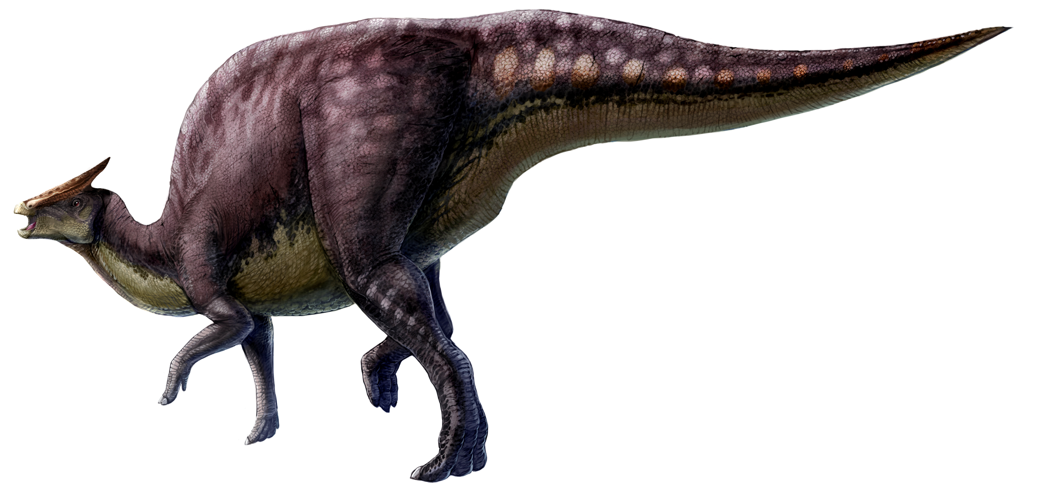
Source: http://upload.wikimedia.org/wikipedia/commons/4/4b/Saurolophus_scalation.png
The first dinosaur ever found in the state was found in 1936 in our own county, Stanislaus, by a 17 year old boy named Al Bennison. He was searching for shell fossils in Del Puerto Canyon near the landslide seen in the photo above when he found some bone fragments on the hillside. They proved to be the remains of a duck-billed dinosaur (or hadrosaur), possibly a creature called a Saurolophus.
These were big creatures, as much as 30 or 35 feet long. They were plant-eaters, and were among the last of the dinosaurs, along with Triceratops and the tyrannosaurs. Bennison's discovery made news at the time, but few people in our county are aware of the awesome paleontological heritage of our region today. I'm hoping that will be changing soon as we prepare a display for the new Great Valley Museum of Natural History at Modesto Junior College.
Source: http://en.wikipedia.org/wiki/Saurolophus
But Bennison wasn't done yet. A year later in another canyon nearby he found the remains of a fearsome marine reptile called a mosasaur. Mosasaurs were probably the top predators of the Late Cretaceous seas, possibly even consuming sharks (yeah, that's a mosasaur you are seeing in the Jurassic World movie trailers, acting like a Sea World Orca). They are descended from ancient terrestrial lizards similar to the Komodo Dragon.
Bennison's mosasaur was a new species and now bears his name: Plotosaurus bennisoni. Like the hadrosaur, few people are aware that they once lived in this region. We have a four-foot long skull of a mosasaur on display in the museum, and a more extensive display is in the planning stages.
Another species of mosasaur, Plotosaurus Tuckeri, was found a few years later a bit further to the south. As can be seen in the diagram below, these creatures approached the size of whales, and would be a terror if they lived in today's oceans.

There have been many other discoveries of Mesozoic dinosaurs and other reptiles like plesiosaurs and ichthyosaurs. The best resource for learning about these fascinating creatures is the book Dinosaurs and Other Mesozoic Reptiles of California by Richard Hilton of Sierra College. Check it out!
From Dinosaurs and other Mesozoic Reptiles of California, by Richard Hilton
I reached the mouth of Del Puerto Canyon and was met with a disturbing sight that was emblematic of the conflict between humans and the natural landscape that we inhabit. More on that in the next post.